Golden Triangle Area

High Temperature
| Location |
Normal |
Warmest Years |
Coldest Years |
| Columbus* |
54.8°F |
81°F (2015)
78°F (1987)
76°F (1987)
71°F (1982)
67°F (1997) |
17°F (1983)
28°F (1985)
30°F (1990)
41°F (1989)
42°F (2010) |
| Starkville* |
54.0°F |
78°F (2015)
78°F (1964)
77°F (2016)
76°F (1955)
76°F (1942) |
17°F (1983)
29°F (1990)
32°F (1989)
34°F (1963)
34°F (1924) |
Low Temperature
| Location |
Normal |
Warmest Years |
Coldest Years |
| Columbus* |
33.9°F |
68°F (1987)
66°F (2015)
66°F (1982)
59°F (2016)
53°F (2008) |
1°F (1983)
14°F (1985)
19°F (1990)
22°F (2013)
23°F (2004) |
| Starkville* |
31.9°F |
63°F (2015)
59°F (1982)
59°F (1955)
58°F (1987)
57°F (2016)
57°F (1944) |
2°F (1983)
3°F (1989)
14°F (1985)
16°F (2004)
16°F (1990) |

| Location |
Wettest Years |
Years With Measurable
Precipitation/Total Years |
| Columbus* |
1.87" (2012)
1.76" (2005)
1.50" (2015)
1.09" (2009)
0.71" (2002) |
16/36
(44%) |
| Starkville* |
3.86" (1926)
1.92" (1973)
1.50" (1914)
1.22" (1969)
1.20" (1913/1897) |
43/120
(36%) |

- 1983 - Extreme cold gripped the Deep South. Four people died in the state of Mississippi as a result of exposure.
- 1989 - A cold wave affected the Deep South, with the coldest air occurring during the days leading up to Christmas. The low temperatures caused water lines to freeze and break across the area.
- 1990 - Significant flooding was reported across the area. 500 homes, 100 businesses, and 44 roads flooded along Luxapallila Creek in Lowndes County and in the city of Columbus. Tibbee Creek flooded 20 homes east of West Point in Clay County. Both creeks crested at major flood stage on Christmas Eve, as did the Tennessee-Tombigbee Waterway at Stennis Lock and Dam.
- 2012 - Strong thunderstorms downed some trees around Lowndes County. More widespread severe weather was reported south of the Golden Triangle.
- 2015 - Afternoon thunderstorms produced isolated pockets of damaging winds, downing power lines on the north side of Columbus and downing a couple of trees near Louisville.

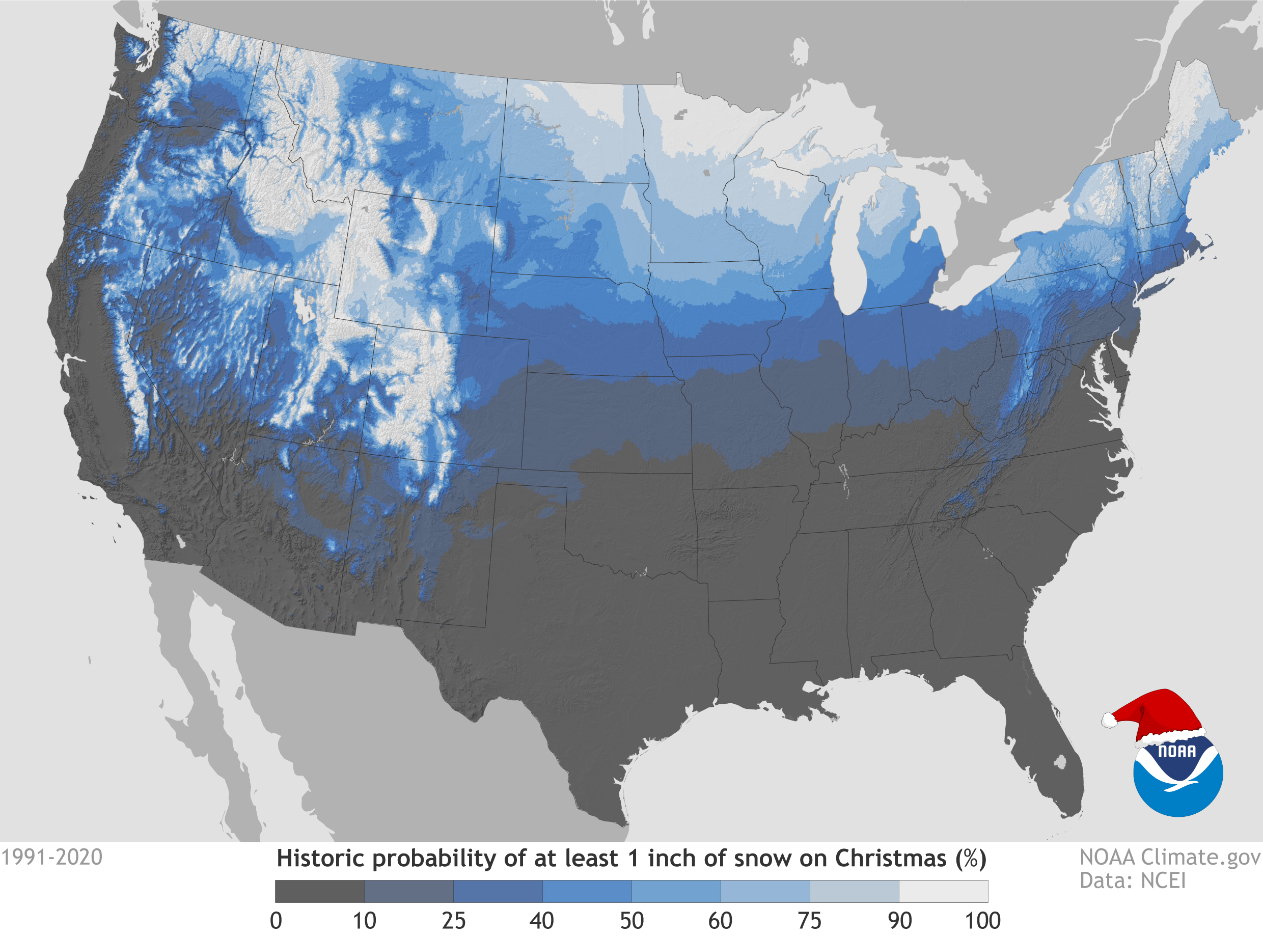
It goes without saying, the probability of experiencing a White Christmas in central Mississippi is very, very low. However, locales in the Golden Triangle area have seen at least one White Christmas over the last century, and a few areas have seen two or three. The map below from the National Climatic Data Center shows the probability of seeing a White Christmas based on past Christmas weather conditions. To qualify as an official White Christmas the snow depth must be at least one inch on Christmas Day. The snowfall does not necessarily need to occur on Christmas Day.
Below is a listing of past White Christmases and a few close calls.
- 1913 - Rain on Christmas Eve night changed over to snow on Christmas morning. A few areas in the Golden Triangle experienced accumulating snowfall with 2" being observed in Starkville on the evening of Christmas day. Elsewhere, only trace amounts were observed at Columbus, Macon, and Louisville. The Louisville COOP observer remarked "On the 25th, snow fell from 4 a.m. to 9 a.m., but...was preceded by rain and melted as fast as it fell..."
- 1929 - Between December 21st and 23rd, a significant winter storm dropped 7 to 11 inches of snow across the area, with 11" reported at Louisville, 10" at Starkville, 9" at Eupora, 8" at Macon, and 7" at Columbus. Very cold temperatures over the following days (including lows in the single digits) allowed snow to stay on the ground for several days. Columbus was the only station that reported daily snow depths in the days following the actual snowfall, and there was still 2" on the ground there on Christmas Day. So it is likely there was still a solid blanket of snow across the entire Golden Triangle area making this an official White Christmas.
- 1935 - On the night of December 21st into the morning of December 22nd, 2 to 5 inches of snow fell across the area. During the following days, high temperatures in the 40s and 50s melted this snow fairly quickly. Though a few locations still noted a trace of snow on the ground Christmas Eve, the snow was gone by Christmas Day.
- 1962 - A light wintry mix fell on Christmas Eve. That night, the precipitation changed to all rain.
- 1963 - A significant winter storm impacted parts of the area on December 22nd and 23rd. While mostly snow fell farther north and west of the Golden Triangle, bringing significant accumulations to those areas, mostly freezing rain and sleet fell in this area, with only some snow mixed in. As a result, accumulations were smaller, with up to two inches reported at area observing sites. Limited snow and ice depth information exists from the following days, but based on observations from surrounding areas, it seems likely that some portions of Webster and Choctaw counties had up to an inch of snow on the ground Christmas morning. Other parts of the area may have still been dealing with lingering ice as temperatures remained mostly in the teens and 20s over the following days. Travel was significantly impacted across the region.
- 1998 - Though it wasn't a White Christmas in the classical sense, it probably looked like one in most areas. A significant ice storm impacted the region from the evening of December 22nd through early Christmas morning. Up to an inch of ice and sleet accumulated in the Golden Triangle area. Power outages were widespread across the area, and holiday travel was severely hampered.
- 2010 - Off and on rain showers became sleet and snow showers on Christmas morning. Though it didn't snow enough for significant accumulations, some locations received between a dusting and an inch of snow, making it a White Christmas for some in the Golden Triangle area. Eupora was one of the sites that reported an inch of snow. Isolated snow showers continued through the morning of December 26th.
|