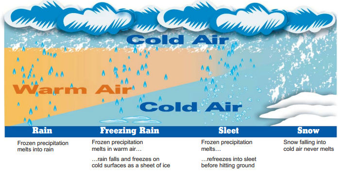
What types of winter precipitation occur in Mississippi?
Mississippi sees a variety of winter precipitation, especially northern Mississippi. Even southern Mississippi has seen winter precipitation in the last several years. Determining the type of precipitation that occurs is tricky and may depend on just a few degrees in temperature, not only at the surface but up higher in the atmosphere. Here is a diagram of how winter precipitation occurs within the atmosphere, keeping in mind that what comes right out of a cloud is already frozen.
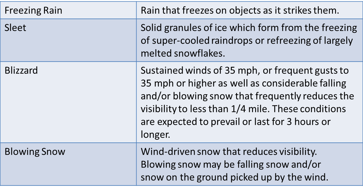
Winter Precipitation Terms to Know

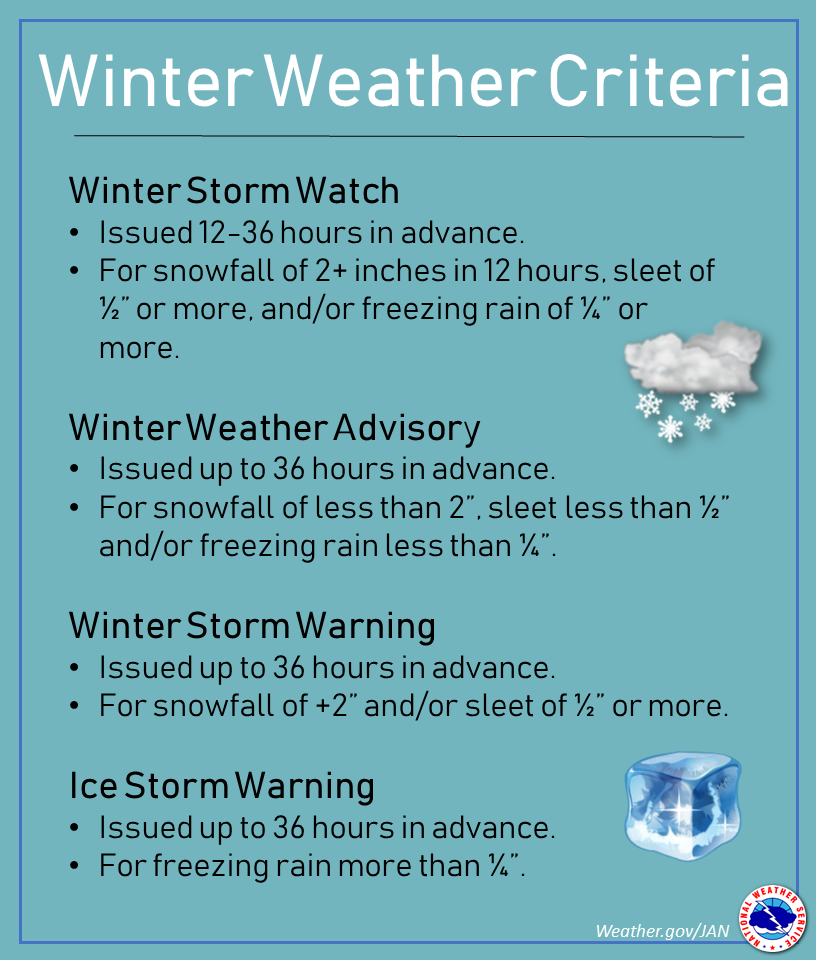
Winter precipitation can vary wildly from the coast to northern Mississippi, and because Mississippi is covered by four different National Weather Service offices, there may be some confusion as to what criteria is used for a winter storm or an ice storm. Here are links to winter weather watch, warnings and statement criteria from Memphis, Jackson, and New Orleans.
Winter Weather Safety Tips
Click for larger images.
Past Winter Precipitation Events
- January 29-February 3, 1951 - A significant ice event took place across much of north and central Mississippi. An estimated 2-3 inches likely occurred around the Jackson area. At least 18 people were injured from falling trees weighed down from the ice. Widespread power outages occurred. Severe damage occurred to the state's timber crop.
- February 9-10, 1994 - The worst ice storm since January 1951 hit north Mississippi. Ice accumulation of 3-6 inches were common across the affected area.
- January 1-2, 2002 -One to three inches of snow fell in southeast Mississippi.
- February 8-9, 2010 -North Mississippi saw snow amounts ranging from a dusting to eight inches.
- February 11-12, 2010 - Heavy snow affected central and south Mississippi. Locations north of Highway 84 generally saw an inch or less, while locations further south received four to six inches. This was the 2nd largest February snowfall event and the 10th overall largest snowfall event on record. Heavy snow spanned a large portion of the South with a substantial swath of 3 to 6 inches which fell from north-central Texas through north and central Louisiana, central and southern Mississippi, Alabama and Georgia.
- January 9-10, 2011 - Four to ten inches of snow fell across north Mississippi, where colder air at the surface and aloft allowed for significant snow totals. Further south across central Mississippi, a critical 1-2 degrees made the difference in seeing snow, ice, or nothing.
- February 9, 2011 - A second round of winter weather hit north and central Mississippi within a week. North Mississippi saw two to six inches of snow, while central areas saw about four to six inches.
- January 28, 2014 - Snow and sleet affected the southern half of Mississippi, leaving the northern half precipitation-free. Significant icing occurred on roadways, and a hard freeze occurred after that left the winter precipitation on the ground for longer than usual.
- February 11-12, 2014 - Cold air was in place when a series of disturbances moved across the region, bringing freezing rain and snow with it. Locations in the Delta region of Mississippi were most affected with ice accumulations of one to two tenths of an inch.
- February 25, 2015 - A series of disturbances moved across the region and with cold air in place, freezing rain and snow developed across the area. Some light icing occurred on February 23 before a stronger disturbance brought in rain and freezing rain, before changing to all snow. Locations in the Delta region of Mississippi saw some four to six inches while six to 8 inches occurred in the Highway 82 corridor in north and northeast Mississippi. This led to snapping trees and numerous power outages.
- January 6, 2017 - Cold air was in place when an upper level disturbance moved through Central Mississippi. It resulted in significant sleet accumulation, followed by a rather long cold snap for the area.
- December 8, 2017 - Cold air moved into the region behind several arctic fronts, and an upper disturbance moved across. This brought a decent snowfall event for portions of Central and South Mississippi.
- January 16-17, 2018 - A second winter weather event occurred during the 2017-2018 winter season. This one brought a rather dry snow to portions of Central and South Mississippi. This event had more of a mixture of precipitation type which limited how much snow fell compared to the December 2017 event.