Louisville, KY
Weather Forecast Office
Begin Time: 4:12 PM EST
End Time: 4:13 PM EST
EF Scale: EF-1
Wind Speed: 90 mph
Begin Point: 1.4 miles WNW of Port Royal, KY
End Point: 1.2 miles WNW of Port Royal, KY
Path Length: 0.25 miles
Path Width: 40 yards
Injuries: 0
Fatalities: 0
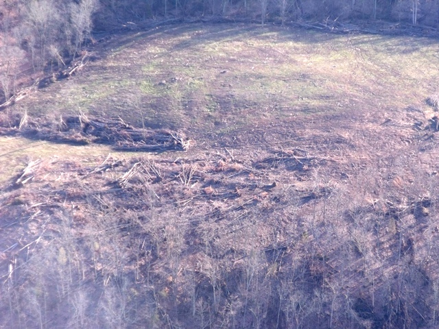
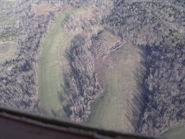
The National Weather Service in conjunction with an aerial damage survey performed by pilots David Katz and Gary Katz and photographer Tom Boucher from the Kentuckiana Volunteer Aviators determined that an EF-1 tornado touched down in northern Henry county on Friday, March 2nd. A thin path of downed trees coincident with a circulation observed on radar was surveyed by the pilots. Numerous trees were uprooted near a pasture east of Port Royal-English Road.
 |
 |
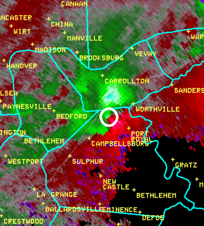
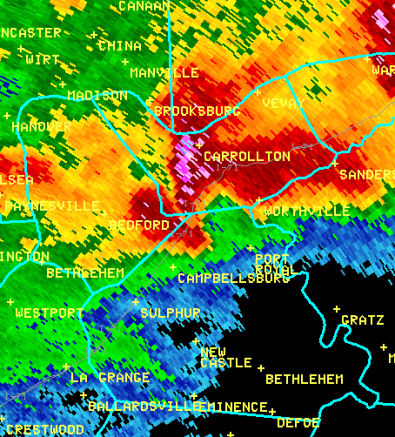
Below are radar pictures from when the tornado was on the ground. On the left we see wind currents in the storm. Green and red colors right next to each other indicate strong winds flowing in opposite directions, implying a circulation between them. The tornado is located within the white circle we have superimposed on the image. On the right is how the storm looked in reflectivity, with a clasic hook shape displayed.
 |
 |
Current Hazards
Hazardous Weather Outlook
Storm Prediction Center
Submit a Storm Report
Advisory/Warning Criteria
Radar
Fort Knox
Evansville
Fort Campbell
Nashville
Jackson
Wilmington
Latest Forecasts
El Nino and La Nina
Climate Prediction
Central U.S. Weather Stories
1-Stop Winter Forecast
Aviation
IDSS Forecast Points
Air Quality
Fire Weather
Recreation Forecasts
1-Stop Drought
Event Ready
1-Stop Severe Forecast
Past Weather
Climate Graphs
1-Stop Climate
CoCoRaHS
Local Climate Pages
Tornado History
Past Derby/Oaks/Thunder Weather
Football Weather
Local Information
About the NWS
Forecast Discussion
Items of Interest
Spotter Training
Regional Weather Map
Decision Support Page
Text Products
Science and Technology
Outreach
LMK Warning Area
About Our Office
Station History
Hazardous Weather Outlook
Local Climate Page
Tornado Machine Plans
Weather Enterprise Resources
US Dept of Commerce
National Oceanic and Atmospheric Administration
National Weather Service
Louisville, KY
6201 Theiler Lane
Louisville, KY 40229-1476
502-969-8842
Comments? Questions? Please Contact Us.


 Weather Story
 Weather Map
 Local Radar