Louisville, KY
Weather Forecast Office
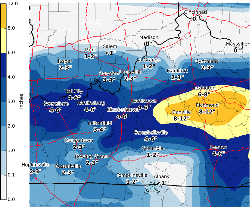
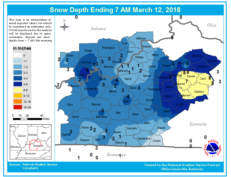
Below is a map of snowfall that occurred across the region March 11-12, 2018. This data was gathered from various reporting sources including trained spotters, trained observers, emergency management, law enforcement, media, department of highways, and the general public. It should be noted that the highest snowfall report received was 10", but the range goes up to 12" on the legend. Please keep in mind that snowfall was hit or miss in some spots and this is and interpolated map. It could be slightly off in your area. You'll also find a second map that shows snow depth observed at 7 AM. Some snow was lost to compaction and melting by this time, and it may differ slightly from the snowfall totals.
Snow on the ground around sunrise today. Some areas may have lost some snow cover between the time snowfall ended and sunrise.
Current Hazards
Hazardous Weather Outlook
Storm Prediction Center
Submit a Storm Report
Advisory/Warning Criteria
Radar
Fort Knox
Evansville
Fort Campbell
Nashville
Jackson
Wilmington
Latest Forecasts
El Nino and La Nina
Climate Prediction
Central U.S. Weather Stories
1-Stop Winter Forecast
Aviation
IDSS Forecast Points
Air Quality
Fire Weather
Recreation Forecasts
1-Stop Drought
Event Ready
1-Stop Severe Forecast
Past Weather
Climate Graphs
1-Stop Climate
CoCoRaHS
Local Climate Pages
Tornado History
Past Derby/Oaks/Thunder Weather
Football Weather
Local Information
About the NWS
Forecast Discussion
Items of Interest
Spotter Training
Regional Weather Map
Decision Support Page
Text Products
Science and Technology
Outreach
LMK Warning Area
About Our Office
Station History
Hazardous Weather Outlook
Local Climate Page
Tornado Machine Plans
Weather Enterprise Resources
US Dept of Commerce
National Oceanic and Atmospheric Administration
National Weather Service
Louisville, KY
6201 Theiler Lane
Louisville, KY 40229-1476
502-969-8842
Comments? Questions? Please Contact Us.


 Weather Story
 Weather Map
 Local Radar