Overview
|
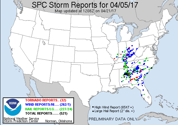
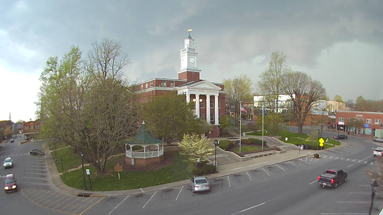
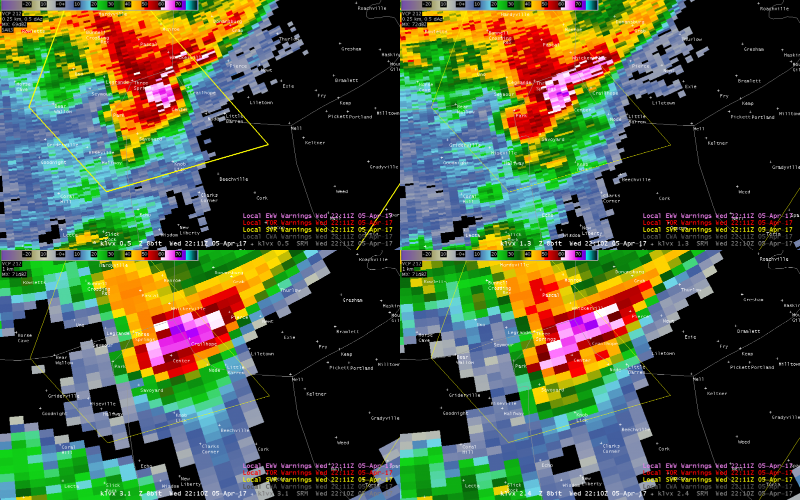
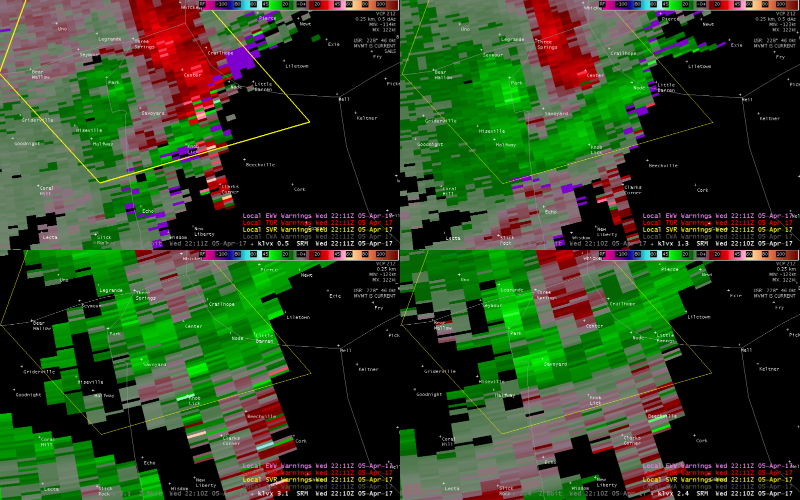
A strong low pressure system moved across the Ohio Valley on Wednesday, April 5. Discrete cells and line segments produced numerous reports of large hail as well as damaging winds and four tornadoes. |
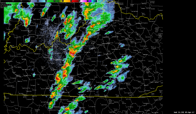 Storms across central KY and southern IN |
 |
 |
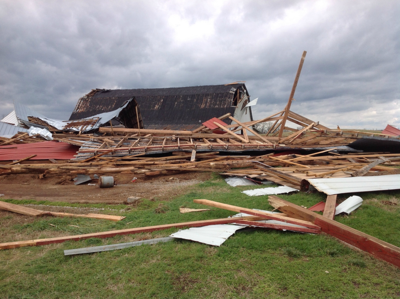 |
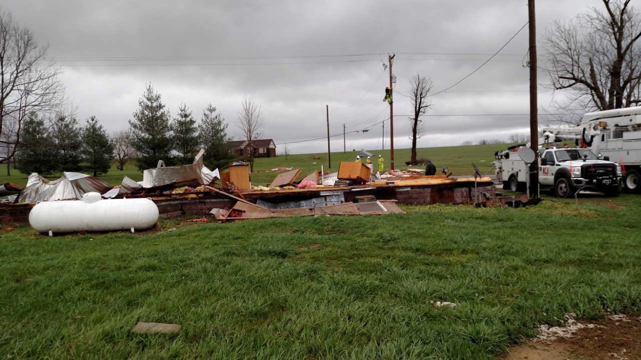
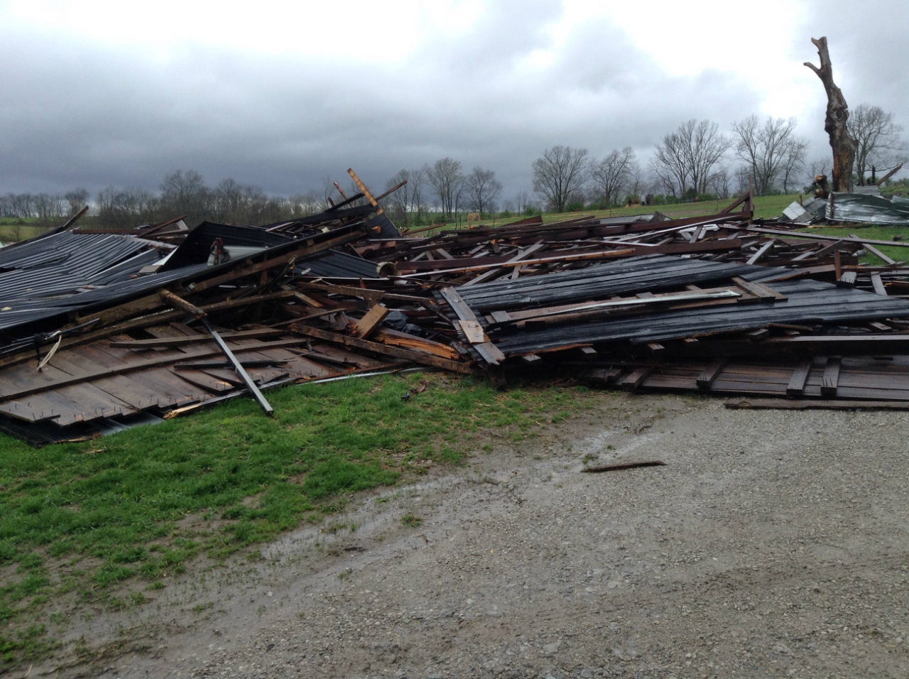
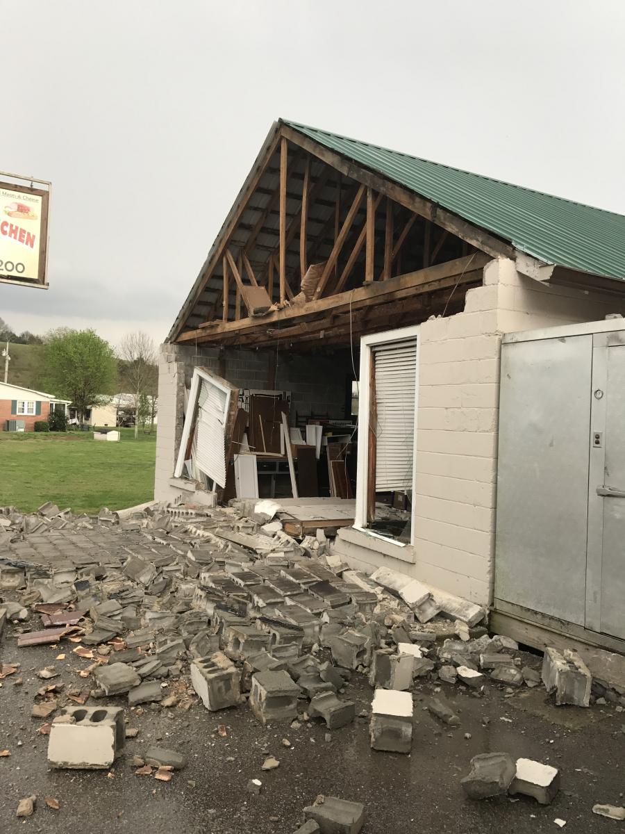
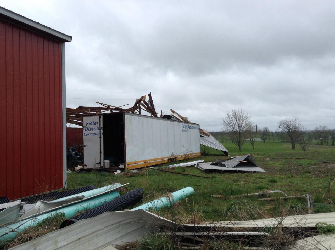
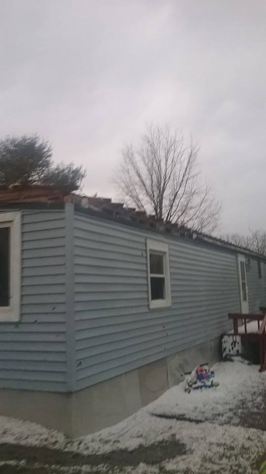
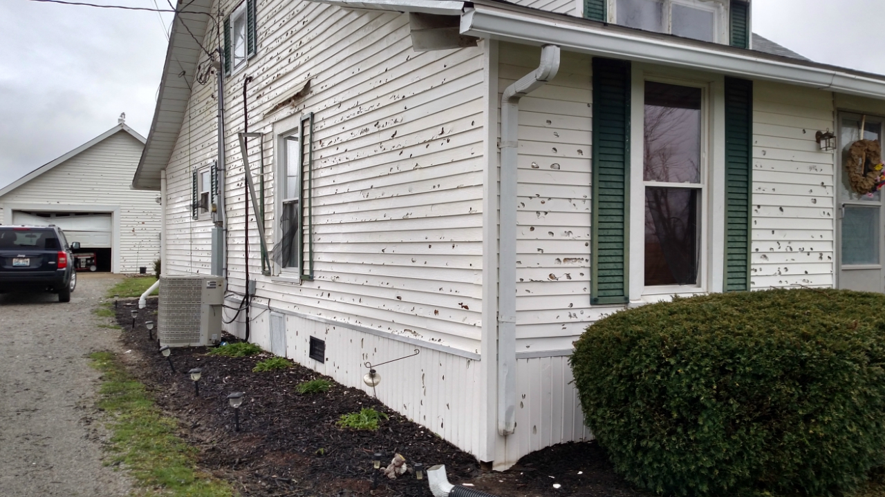
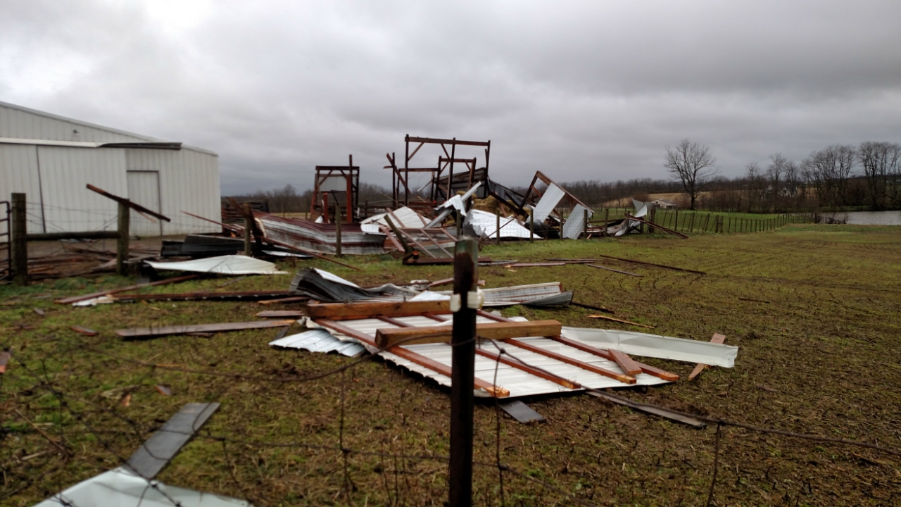
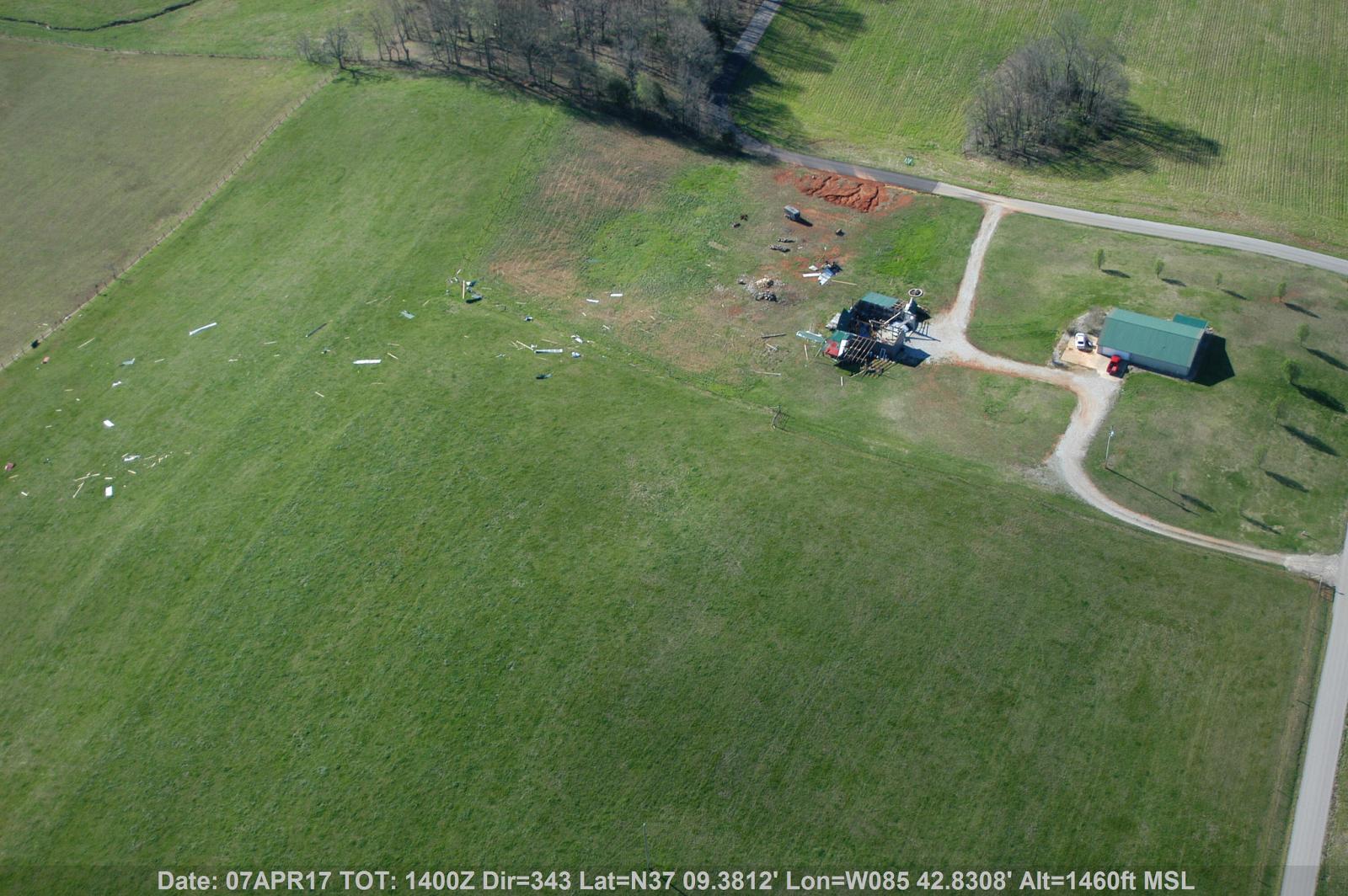
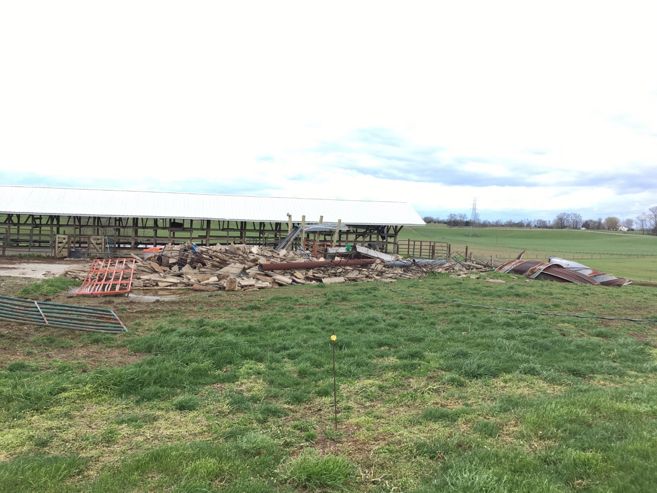
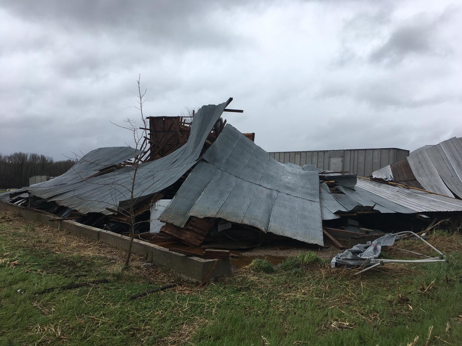
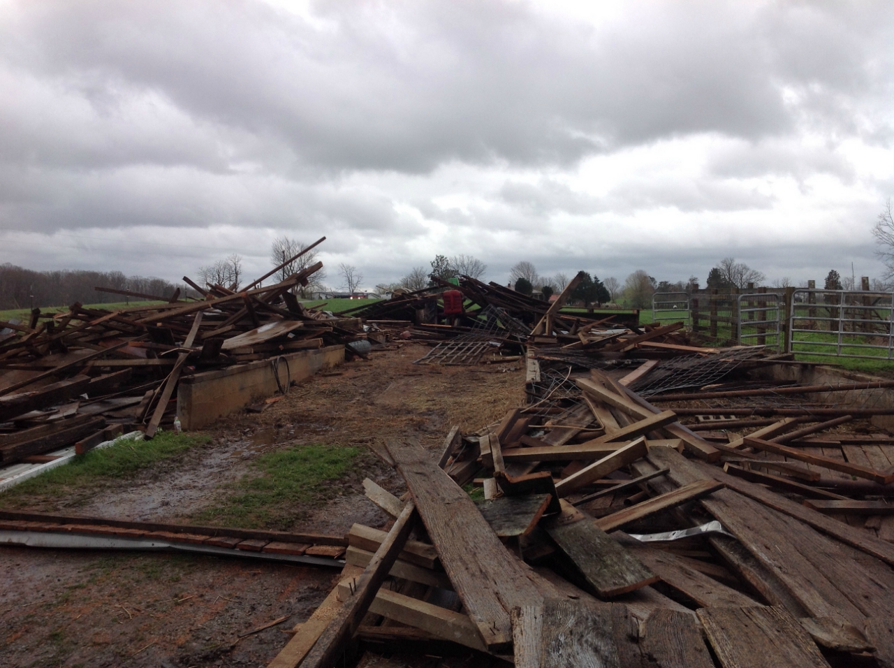
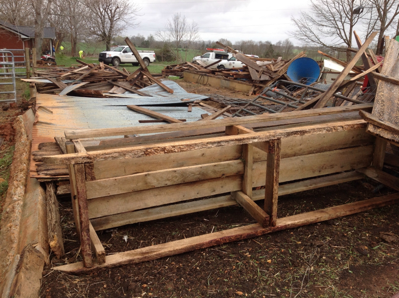
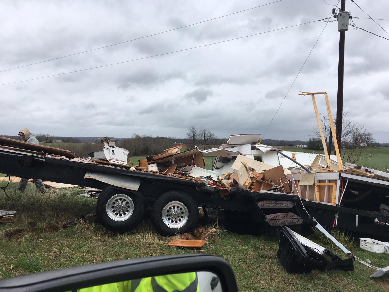
| SPC storm reports | Mobile home destroyed near Eminence, KY | Barn destroyed near Center, KY |
Tornadoes:
|
|
||||||||||
|
||||||||||
|
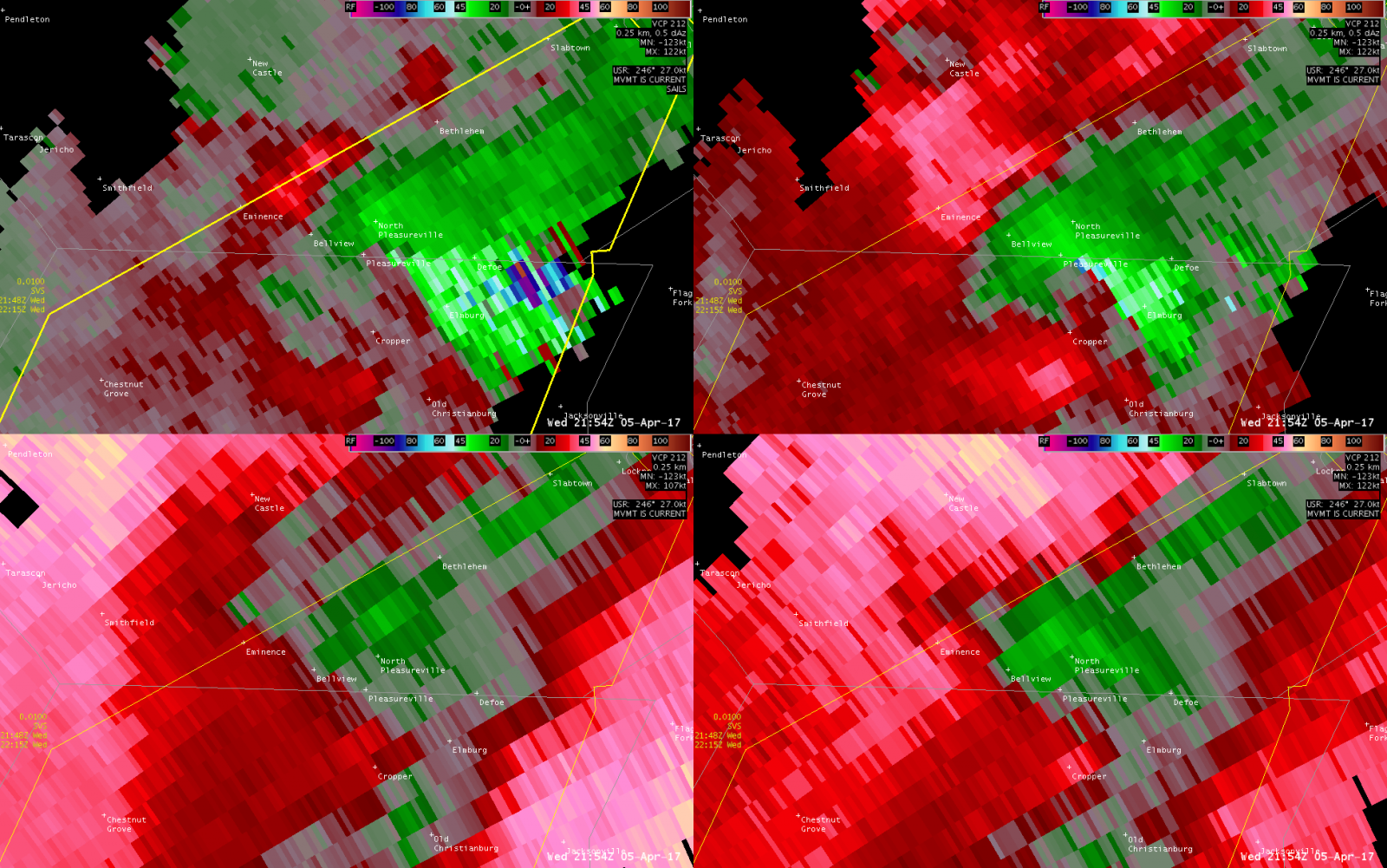
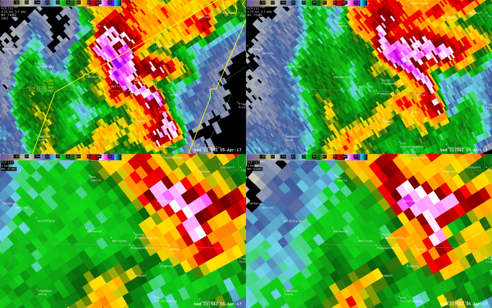
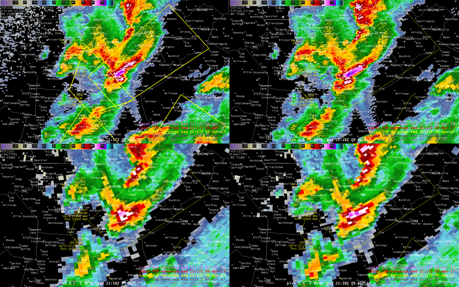
Tornado #1 - EMINENCE/PLEASUREVILLE
Track Map 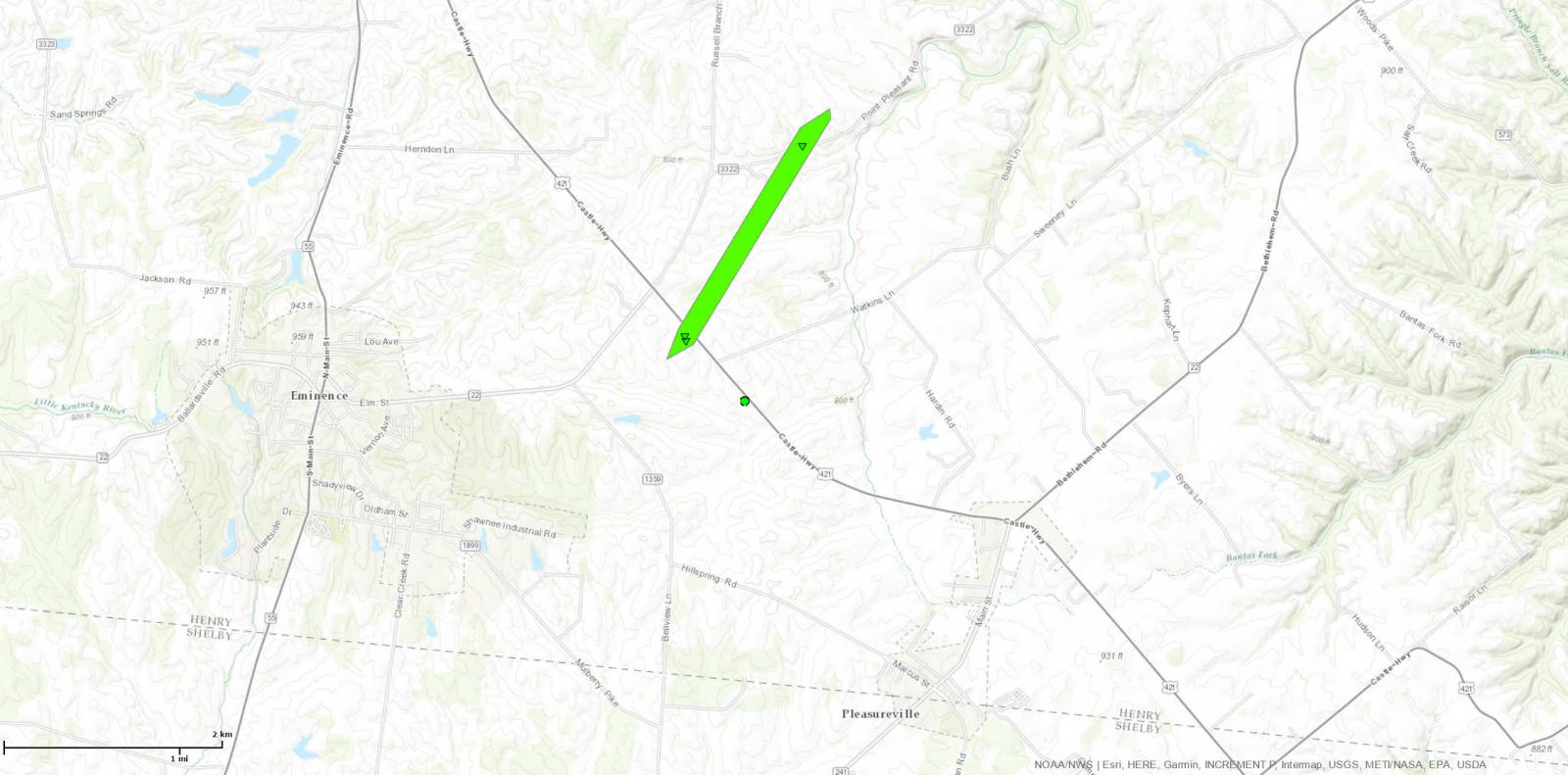 
Downloadable KMZ File |
||||||||||||||||
|
||||||||||||||||
|
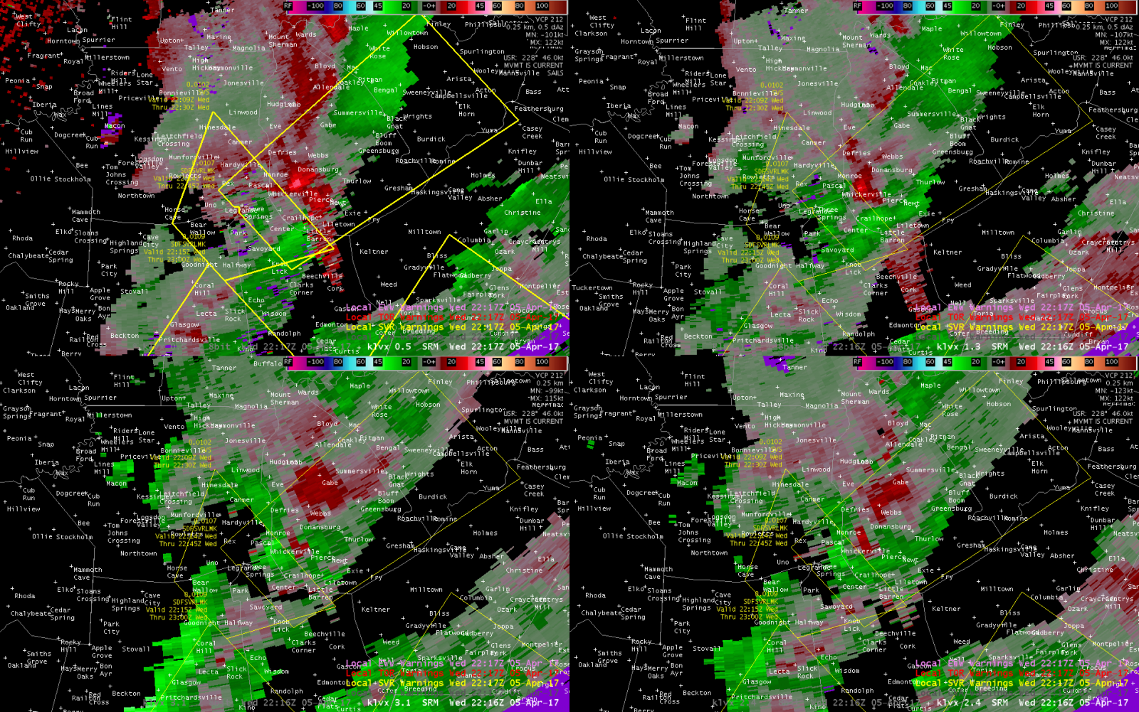
Tornado #2 - NW of CENTER, KY
Track Map 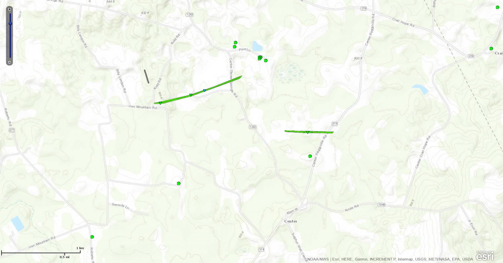
Downloadable KMZ File |
||||||||||||||||
|
||||||||||||||||
|
Tornado #3 - N of CENTER, KY
Track Map
Downloadable KMZ File |
||||||||||||||||
|
||||||||||||||||
|
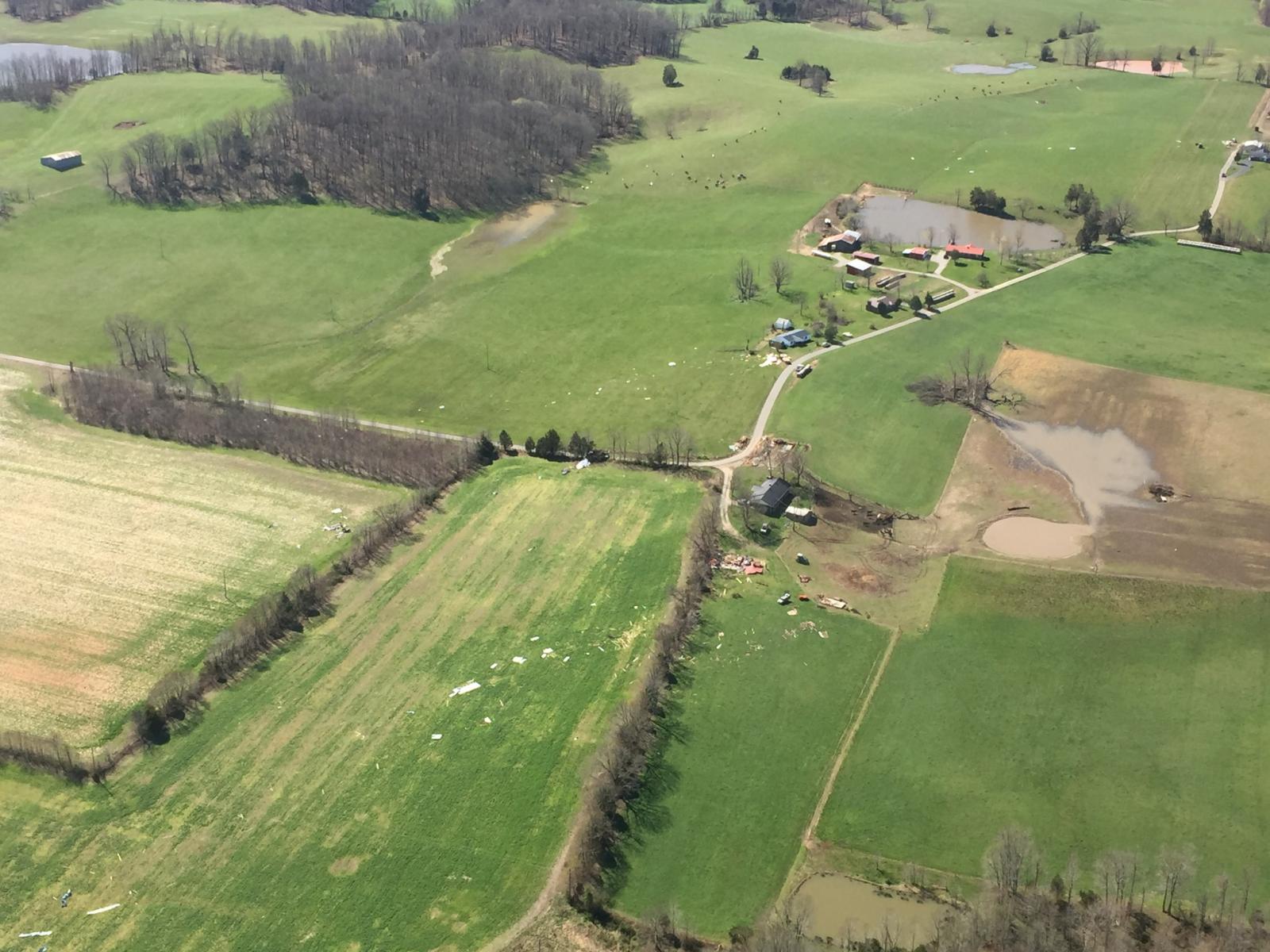
Tornado #4 - PIERCE, KY
Track Map 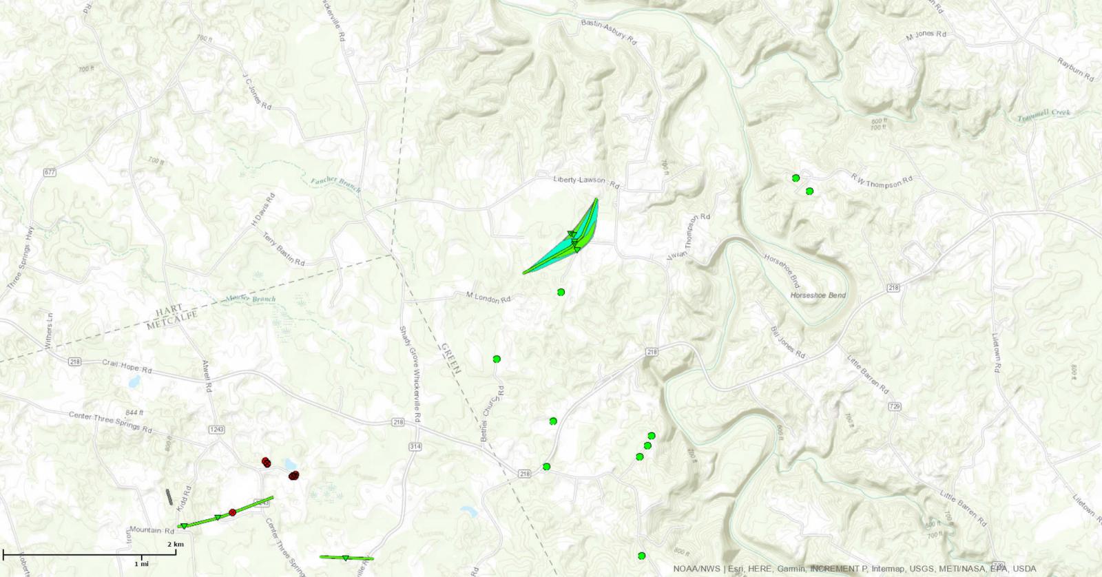
Downloadable KMZ File |
|||||||||||||||||
|
|||||||||||||||||
The Enhanced Fujita (EF) Scale classifies tornadoes into the following categories:
| EF0 Weak 65-85 mph |
EF1 Moderate 86-110 mph |
EF2 Significant 111-135 mph |
EF3 Severe 136-165 mph |
EF4 Extreme 166-200 mph |
EF5 Catastrophic 200+ mph |
 |
|||||
Wind & Hail:
Wind
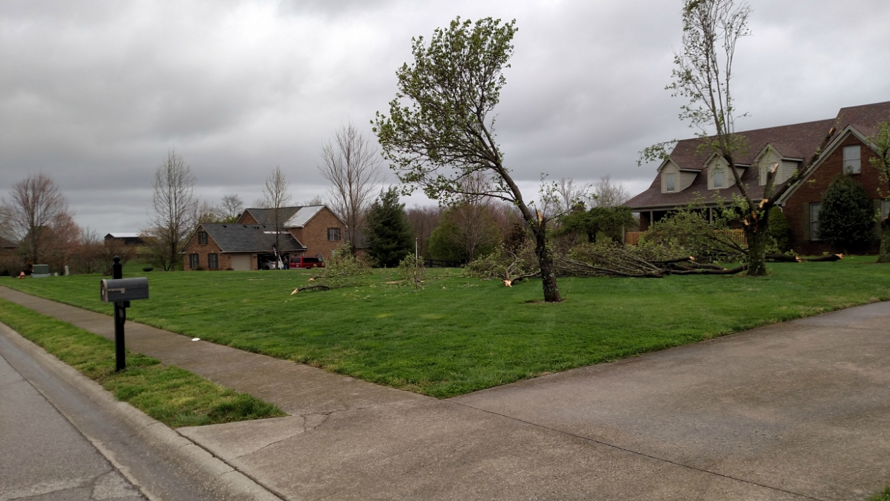
High winds resulted in multiple reports of damage to barns and buildings as well as trees, mainly across central KY. The highest recorded wind gust was 72 mph by a trained spotter near Frankfort, KY.
 |
 |
 |
 |
| Wind damage near Stamping Ground, KY. Photo from NWS storm survey. | Building damaged in Marrowbone, KY. Photo credit: Greg Cary | Tree damage northeast of Richmond, KY. Photo from NWS storm survey. | Barn damaged near Cynthiana, KY. Photo from NWS storm survey. |
Hail
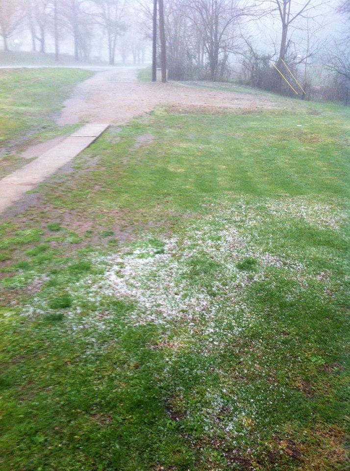
Many reports of hail were received from the storms across the region. There were multiple reports of golf ball size hail across southern IN and central KY. In addition, some storms produced enough hail to cover the ground up to a few inches deep.
 |
 |
 |
 |
| Hail north of Richmond, KY. Photo credit: Billy England | Hail covering the ground and wind damage near Eminence, KY. Photo credit: Martin Washburn | Hail near Middleburg, KY. Photo credit: Patrick Jones | Golf ball size hail near Lockport, KY. |
Photos & Video:
 |
| Supercell near Glasgow, KY (AAA Systems and WBKO) |
Storm Reports
PRELIMINARY LOCAL STORM REPORT...SUMMARY
NATIONAL WEATHER SERVICE LOUISVILLE KY
750 AM EDT FRI APR 7 2017

..TIME...   ...EVENT...      ...CITY LOCATION...     ...LAT.LON...
..DATE...   ....MAG....      ..COUNTY LOCATION..ST.. ...SOURCE....
            ..REMARKS..

0338 PM     HAIL             1 ENE DUNBAR            37.19N 86.75W
04/05/2017  E0.75 INCH       BUTLER             KY   PUBLIC

            DIME SIZE HAIL IN DUNBAR.

0345 PM     HAIL             5 SSE LEWISPORT         37.86N 86.88W
04/05/2017  E0.75 INCH       HANCOCK            KY   CO-OP OBSERVER

            DIME SIZE HAIL.

0355 PM     HAIL             HARDINSBURG             37.78N 86.46W
04/05/2017  E0.88 INCH       BRECKINRIDGE       KY   PUBLIC


0358 PM     HAIL             HARNED                  37.75N 86.41W
04/05/2017  E1.50 INCH       BRECKINRIDGE       KY   LAW ENFORCEMENT


0404 PM     HAIL             IRVINGTON               37.88N 86.29W
04/05/2017  E0.88 INCH       BRECKINRIDGE       KY   PUBLIC


0414 PM     HAIL             3 SSE DUNBAR            37.14N 86.74W
04/05/2017  E0.75 INCH       BUTLER             KY   PUBLIC


0418 PM     HAIL             CROMWELL                37.33N 86.80W
04/05/2017  E1.00 INCH       BUTLER             KY   BROADCAST MEDIA

            TWITTER REPORT RELAYED FROM VIEWER OF
            QUARTER-SIZED HAIL AND SMALLER IN CROMWELL.
            TIME ESTIMATED BASED ON RADAR.

0428 PM     HAIL             4 E ROSINE              37.46N 86.68W
04/05/2017  E1.75 INCH       OHIO               KY   PUBLIC

            NEAR HORSE BRANCH.

0435 PM     HAIL             RAMSEY                  38.32N 86.15W
04/05/2017  E0.75 INCH       HARRISON           IN   PUBLIC

            DIME SIZE HAIL.

0439 PM     HAIL             GEORGETOWN              38.30N 85.97W
04/05/2017  E0.88 INCH       FLOYD              IN   BROADCAST MEDIA


0440 PM     HAIL             LANESVILLE              38.24N 85.99W
04/05/2017  E0.88 INCH       HARRISON           IN   BROADCAST MEDIA

            DIME TO NICKEL HAIL.

0442 PM     HAIL             GEORGETOWN              38.29N 85.97W
04/05/2017  E1.75 INCH       FLOYD              IN   BROADCAST MEDIA


0446 PM     HAIL             1 WNW EDWARDSVILLE      38.29N 85.92W
04/05/2017  E1.00 INCH       FLOYD              IN   BROADCAST MEDIA


0450 PM     HAIL             1 NE FLOYDS KNOBS       38.32N 85.86W
04/05/2017  E0.88 INCH       FLOYD              IN   TRAINED SPOTTER

            DIME TO NICKEL HAIL.

0451 PM     HAIL             EDWARDSVILLE            38.28N 85.90W
04/05/2017  E1.00 INCH       FLOYD              IN   BROADCAST MEDIA


0452 PM     HAIL             1 NNE FLOYDS KNOBS      38.32N 85.86W
04/05/2017  E1.75 INCH       FLOYD              IN   BROADCAST MEDIA


0455 PM     HAIL             1 WNW MEMPHIS           38.49N 85.79W
04/05/2017  E0.75 INCH       CLARK              IN   PUBLIC

            DIME-SIZED HAIL REPORTED ON MCCLELLAN RD.

0456 PM     HAIL             2 WNW HARDINSBURG       37.79N 86.49W
04/05/2017  E0.75 INCH       BRECKINRIDGE       KY   BROADCAST MEDIA

            PEA TO DIME HAIL.

0502 PM     HAIL             1 SE BOWLING GREEN      36.96N 86.42W
04/05/2017  E0.75 INCH       WARREN             KY   OTHER FEDERAL

            DIME SIZE HAIL AT WARREN COUNTY AIRPORT
            REPORTED BY CIVIL AIR PATROL.

0504 PM     HAIL             6 NE WOLF CREEK         38.15N 86.31W
04/05/2017  E0.88 INCH       MEADE              KY   TRAINED SPOTTER


0505 PM     TSTM WND GST     2 SSE EMINENCE          38.34N 85.16W
04/05/2017  M56 MPH          SHELBY             KY   MESONET


0507 PM     HAIL             RAMSEY                  38.32N 86.15W
04/05/2017  E1.00 INCH       HARRISON           IN   PUBLIC


0510 PM     TSTM WND GST     1 SE PLUM SPRINGS       37.01N 86.37W
04/05/2017  M62 MPH          WARREN             KY   MESONET


0510 PM     TSTM WND DMG     2 ENE PLUM SPRINGS      37.03N 86.36W
04/05/2017                   WARREN             KY   TRAINED SPOTTER

            SHINGLES OFF A HOME NEAR WARREN EAST HIGH
            SCHOOL.

0511 PM     TSTM WND GST     3 NE RICH POND          36.93N 86.47W
04/05/2017  M50 MPH          WARREN             KY   MESONET


0511 PM     HAIL             1 W PALMYRA             38.41N 86.13W
04/05/2017  M1.25 INCH       HARRISON           IN   PUBLIC


0517 PM     HAIL             PALMYRA                 38.41N 86.11W
04/05/2017  E1.75 INCH       HARRISON           IN   TRAINED SPOTTER


0517 PM     HAIL             3 WSW WINDYVILLE        37.21N 86.38W
04/05/2017  E1.00 INCH       EDMONSON           KY   PUBLIC


0517 PM     TSTM WND DMG     2 ENE SWEEDEN           37.26N 86.26W
04/05/2017                   EDMONSON           KY   PUBLIC

            POWER LINES DOWN.

0518 PM     TSTM WND DMG     2 NNE RICH POND         36.92N 86.49W
04/05/2017                   WARREN             KY   PUBLIC

            TREES DAMAGED. REPORT VIA MPING. TIME
            ESTIMATED BASED ON RADAR, WHICH HAD TWO
            CELLS GO OVER THAT AREA. USED THE STRONGER
            SECOND CELL.

0521 PM     TSTM WND DMG     1 NNE IRVINGTON         37.90N 86.28W
04/05/2017                   BRECKINRIDGE       KY   BROADCAST MEDIA

            POWER LINES DOWN ON KY 79.

0522 PM     HAIL             2 W BOWLING GREEN       36.97N 86.48W
04/05/2017  E1.00 INCH       WARREN             KY   TRAINED SPOTTER


0523 PM     HAIL             3 WNW BOWLING GREEN     36.99N 86.49W
04/05/2017  E1.75 INCH       WARREN             KY   TRAINED SPOTTER

            VETERANS MEMORIAL PARKWAY AND MORGANTOWN
            ROAD.

0523 PM     HAIL             1 NNW BOWLING GREEN     36.99N 86.45W
04/05/2017  E1.75 INCH       WARREN             KY   BROADCAST MEDIA


0525 PM     HAIL             2 SW ELIZABETHTOWN      37.68N 85.91W
04/05/2017  E0.88 INCH       HARDIN             KY   PUBLIC


0525 PM     TSTM WND DMG     1 SSW PLUM SPRINGS      37.00N 86.39W
04/05/2017                   WARREN             KY   PUBLIC

            ROOF SUSTAINED A FAIR AMOUNT OF DAMAGE ON
            HOME. TIME ESTIMATED BASED ON RADAR AND
            APPROXIMATE TIME OF REPORT FROM OBSERVER.

0525 PM     HAIL             ELIZABETHTOWN           37.70N 85.87W
04/05/2017  E1.00 INCH       HARDIN             KY   AMATEUR RADIO


0527 PM     TSTM WND DMG     1 NNW ELIZABETHTOWN     37.72N 85.88W
04/05/2017                   HARDIN             KY   NWS STORM SURVEY

            UPROOTED TREE FELL ON ROOF OF MOBILE HOME.
            WIND SPEED ESTIMATED 70-75 MPH.

0529 PM     TSTM WND DMG     2 NW OAKLAND            37.06N 86.27W
04/05/2017                   WARREN             KY   PUBLIC

            BARN DAMAGED.

0530 PM     TSTM WND GST     4 SSW SIMPSONVILLE      38.17N 85.38W
04/05/2017  M58 MPH          SHELBY             KY   MESONET


0530 PM     TSTM WND DMG     1 ENE ELIZABETHTOWN     37.71N 85.85W
04/05/2017                   HARDIN             KY   TRAINED SPOTTER

            MOBILE HOME BLOWN OVER.

0534 PM     TSTM WND DMG     4 ENE RICHARDSVILLE     37.11N 86.42W
04/05/2017                   WARREN             KY   TRAINED SPOTTER

            POWER LINES DOWN.

0534 PM     HAIL             4 ENE RICHARDSVILLE     37.11N 86.42W
04/05/2017  E1.75 INCH       WARREN             KY   TRAINED SPOTTER


0545 PM     HAIL             BOSTON                  37.78N 85.67W
04/05/2017  E1.75 INCH       NELSON             KY   EMERGENCY MNGR


0546 PM     HAIL             ALVATON                 36.87N 86.35W
04/05/2017  E1.75 INCH       WARREN             KY   PUBLIC


0547 PM     HAIL             BOSTON                  37.78N 85.67W
04/05/2017  E1.00 INCH       NELSON             KY   EMERGENCY MNGR


0550 PM     TSTM WND DMG     CENTER                  37.13N 85.68W
04/05/2017                   METCALFE           KY   EMERGENCY MNGR

            TREES DOWN, BUILDING DAMAGE, POWER LINES
            DOWN.

0553 PM     TSTM WND DMG     2 ENE EMINENCE          38.38N 85.15W
04/05/2017                   HENRY              KY   BROADCAST MEDIA

            A ROOF WAS BLOWN OFF A MODULAR HOME. FOUR TO
            5 BARNS WERE DESTROYED. A MOBILE HOME WAS
            DESTROYED NEAR WATKINS LANE. TREES WERE
            DOWNED. BOARDS WERE PEELED OFF A FENCE.

0554 PM     TORNADO          2 ENE EMINENCE          38.38N 85.14W
04/05/2017                   HENRY              KY   NWS STORM SURVEY

            BARNS DAMAGED, GARAGE DOOR BLOWN IN.
            ANTICYCLONIC TORNADO. ALSO HAIL DAMAGE TO
            SIDING ON HOMES.

0555 PM     TSTM WND DMG     3 W BETHLEHEM           38.40N 85.12W
04/05/2017                   HENRY              KY   AMATEUR RADIO

            BARNS DOWN ALONG POINT PLEASANT ROAD.

0555 PM     HAIL             1 ENE BETHLEHEM         38.40N 85.06W
04/05/2017  E1.00 INCH       HENRY              KY   EMERGENCY MNGR


0557 PM     HAIL             2 SSE MUNFORDVILLE      37.26N 85.89W
04/05/2017  E0.88 INCH       HART               KY   PUBLIC


0600 PM     HAIL             BARDSTOWN               37.81N 85.46W
04/05/2017  E0.25 INCH       NELSON             KY   PUBLIC

            HAIL COVERED THE GROUND WITH SEVERAL INCHES
            OF DEPTH.

0600 PM     HAIL             FAIRFIELD               37.93N 85.38W
04/05/2017  E1.00 INCH       NELSON             KY   PUBLIC


0603 PM     HAIL             2 W LOCKPORT            38.43N 85.02W
04/05/2017  E1.75 INCH       HENRY              KY   TRAINED SPOTTER


0603 PM     TSTM WND DMG     3 SW HISEVILLE          37.07N 85.86W
04/05/2017                   BARREN             KY   EMERGENCY MNGR

            BARNS FLATTENED BETWEEN GLASGOW AND
            HISEVILLE.

0606 PM     HAIL             LOCKPORT                38.43N 84.98W
04/05/2017  E1.75 INCH       HENRY              KY   PUBLIC


0606 PM     HAIL             CROPPER                 38.32N 85.12W
04/05/2017  E1.00 INCH       SHELBY             KY   BROADCAST MEDIA
0611 PM     TORNADO          2 NW CENTER             37.15N 85.71W
04/05/2017                   METCALFE           KY   NWS STORM SURVEY

            BARNS DAMAGED...60 FT SILO COLLAPSED...TREE
            DAMAGE.
0612 PM     TORNADO          1 NNW CENTER            37.15N 85.70W
04/05/2017                   METCALFE           KY   NWS STORM SURVEY

            TREE DAMAGE. WELL BUILT BARN DESTROYED AND
            DEBRIS THROWN ONE QUARTER MILE. THE DURATION
            OF THE TORNADO EVENT WAS 1 MINUTE.
0612 PM     TSTM WND DMG     3 N CENTER              37.18N 85.68W
04/05/2017                   GREEN              KY   EMERGENCY MNGR

            BARN DESTROYED.

0613 PM     HAIL             BLOOMFIELD              37.91N 85.32W
04/05/2017  E0.88 INCH       NELSON             KY   BROADCAST MEDIA


0615 PM     HAIL             FAIRFIELD               37.93N 85.38W
04/05/2017  E1.00 INCH       NELSON             KY   PUBLIC
0616 PM     TORNADO          3 W PIERCE              37.18N 85.67W
04/05/2017                   GREEN              KY   NWS STORM SURVEY

            LARGE WELL BUILT BARN DESTROYED. TWO SMALL
            OUTBUILDINGS AND A FIFTH WHEELER DESTROYED.
            DEBRIS BLOWN 1/4 MILE TO THE NORTHEAST
            EXHIBITED CONVERGENCE AND ROTATION.


0617 PM     TSTM WND DMG     PIERCE                  37.18N 85.62W
04/05/2017                   GREEN              KY   BROADCAST MEDIA

            RELAYED VIEWER IMAGE OF A TREE UPROOTED.
            TIME ESTIMATED BASED ON RADAR.

0618 PM     TSTM WND DMG     MARROWBONE              36.82N 85.50W
04/05/2017                   CUMBERLAND         KY   EMERGENCY MNGR

            BUILDING WALL BLOWN DOWN.

0620 PM     TSTM WND DMG     1 NE HOLLAND            36.70N 86.06W
04/05/2017                   ALLEN              KY   PUBLIC

            TORE PART OF ROOF OFF BARN. TOSSED INTO
            ROAD. TIME ESTIMATED BASED ON RADAR.

0625 PM     HAIL             GREENSBURG              37.26N 85.50W
04/05/2017  E1.75 INCH       GREEN              KY   PUBLIC


0625 PM     TSTM WND DMG     GREENSBURG              37.26N 85.50W
04/05/2017                   GREEN              KY   EMERGENCY MNGR

            TREES DOWN.

0634 PM     TSTM WND GST     2 NE ALTON              38.11N 84.91W
04/05/2017  M72 MPH          FRANKLIN           KY   TRAINED SPOTTER


0640 PM     TSTM WND DMG     LEBANON                 37.57N 85.26W
04/05/2017                   MARION             KY   911 CALL CENTER

            TREE DOWN ON DAUGHERTY AVE AND MILLER PIKE.

0640 PM     TSTM WND GST     4 WSW MILLVILLE         38.12N 84.88W
04/05/2017  M57 MPH          FRANKLIN           KY   MESONET


0643 PM     HAIL             1 S CAMPBELLSVILLE      37.33N 85.35W
04/05/2017  E1.25 INCH       TAYLOR             KY   TRAINED SPOTTER


0645 PM     TSTM WND DMG     3 W FRANKFORT           38.19N 84.93W
04/05/2017                   FRANKLIN           KY   911 CALL CENTER

            TREES DOWN REPORTED AT PEARIDGE RD,
            FRANKFORT, KY.

0647 PM     TSTM WND DMG     1 S MANNSVILLE          37.35N 85.20W
04/05/2017                   TAYLOR             KY   PUBLIC

            FACEBOOK REPORT OF TREE'S DOWNED AT GADDIS
            RIDGE ROAD AND A BARN DAMAGED. TIME
            ESTIMATED BASED ON RADAR.

0654 PM     TSTM WND GST     3 WSW GEORGETOWN        38.18N 84.60W
04/05/2017  M62 MPH          SCOTT              KY   PUBLIC

            MEASURED AT PRIVATE WEATHER STATION.

0655 PM     TSTM WND DMG     2 ENE GEORGETOWN        38.22N 84.52W
04/05/2017                   SCOTT              KY   911 CALL CENTER

            SMALL TREE LIMBS DOWN.

0655 PM     TSTM WND GST     2 E STAMPING GROUND     38.27N 84.65W
04/05/2017  E65 MPH          SCOTT              KY   NWS STORM SURVEY

            DAMAGE TO BARNS AND OUTBUILDINGS, LARGE
            LIMBS DOWN ALONG DUVALL STATION ROAD.

0700 PM     TSTM WND DMG     1 SSW NEW ZION          38.18N 84.49W
04/05/2017                   SCOTT              KY   EMERGENCY MNGR

            TREES DOWN.

0703 PM     HAIL             3 W PERRYVILLE          37.65N 85.01W
04/05/2017  E0.75 INCH       BOYLE              KY   TRAINED SPOTTER

            DIME SIZE HAIL.

0704 PM     TSTM WND GST     2 WNW OXFORD            38.28N 84.57W
04/05/2017  M57 MPH          SCOTT              KY   AMATEUR RADIO

            911 CENTER IS ON BACKUP POWER. POWER IS OUT
            IN PARTS OF GEORGETOWN.

0704 PM     TSTM WND DMG     3 E OXFORD              38.27N 84.47W
04/05/2017                   SCOTT              KY   NWS STORM SURVEY

            BARN AND TREE DAMAGE. SHEETING THROWN 400
            YARDS. ESTIMATED 70 MPH WINDS.

0705 PM     TSTM WND DMG     2 NNW GEORGETOWN        38.23N 84.57W
04/05/2017                   SCOTT              KY   EMERGENCY MNGR

            DAMAGE TO ROOF REPORTED AT SCOTT COUNTY HIGH
            SCHOOL.

0705 PM     HAIL             GEORGETOWN              38.21N 84.55W
04/05/2017  E1.00 INCH       SCOTT              KY   PUBLIC

            TWITTER REPORT OF QUARTER-SIZED HAIL IN
            GEORGETOWN. TIME ESTIMATED BASED ON RADAR
            AND TIME OF REPORT.

0714 PM     TSTM WND DMG     3 WSW CYNTHIANA         38.38N 84.35W
04/05/2017                   HARRISON           KY   NWS STORM SURVEY

            DAMAGE DONE TO OLD BARN. SHEETING THROWN 400
            YARDS. MINOR DAMAGE TO ROHS OPERA HOUSE IN
            CYNTHIANA.

0715 PM     TSTM WND DMG     2 WNW CYNTHIANA         38.39N 84.33W
04/05/2017                   HARRISON           KY   911 CALL CENTER

            REPORT OF A ROOF OFF A HOUSE ON SPRUCE DRIVE
            AND KY STATE HWY 365.

0720 PM     TSTM WND DMG     3 NE DANVILLE           37.67N 84.73W
04/05/2017                   BOYLE              KY   EMERGENCY MNGR

            TREES AND POWER LINES DOWN AT HWY 34 AND
            TAYLOR RD.

0729 PM     TSTM WND GST     1 SE NICHOLASVILLE      37.87N 84.57W
04/05/2017  M58 MPH          JESSAMINE          KY   PUBLIC

            REPORTED AT PRIVATE WEATHER STATION.

0735 PM     TSTM WND DMG     1 SW BRYANTSVILLE       37.71N 84.66W
04/05/2017                   GARRARD            KY   PUBLIC

            SHINGLES TORN OFF THE ROOF OF A HOUSE.

0735 PM     TSTM WND DMG     5 NNW SPEARS            37.93N 84.50W
04/05/2017                   JESSAMINE          KY   EMERGENCY MNGR

            TREES DOWN ON POWER LINES. 300 TO 400
            CUSTOMERS IN JESSAMINE COUNTY WITHOUT POWER.

0750 PM     TSTM WND DMG     5 S LEXINGTON           37.97N 84.47W
04/05/2017                   FAYETTE            KY   PUBLIC

            SHINGLES BLOWN OFF A HOME. ONE INCH TREE
            LIMBS SNAPPED.

0804 PM     HAIL             2 ESE VALLEY VIEW       37.82N 84.40W
04/05/2017  E2.00 INCH       MADISON            KY   EMERGENCY MNGR


0805 PM     HAIL             5 W FORD                37.88N 84.33W
04/05/2017  E1.00 INCH       MADISON            KY   PUBLIC

            TWITTER REPORT AT EXIT 97 ON I-75 NORTH OF
            RICHMOND.

0805 PM     HAIL             7 SE LEXINGTON          37.96N 84.39W
04/05/2017  E1.00 INCH       FAYETTE            KY   PUBLIC

            REPORTED THROUGH MPING. TIME ESTIMATED BASED
            ON RADAR.

0805 PM     HAIL             6 WNW FORD              37.90N 84.35W
04/05/2017  E1.75 INCH       FAYETTE            KY   PUBLIC

            ALSO HAD A WINDOW PANE BLOWN OUT AND SOME
            SHINGLES DAMAGED.

0807 PM     HAIL             3 WNW REDHOUSE          37.85N 84.32W
04/05/2017  M1.00 INCH       MADISON            KY   EMERGENCY MNGR

            HAIL HALF INCH TO QUARTER SIZE.

0817 PM     TSTM WND DMG     WINCHESTER              38.00N 84.19W
04/05/2017                   CLARK              KY   EMERGENCY MNGR

            POWER LINES DOWN. TREE ON A HOUSE.

0820 PM     HAIL             WINCHESTER              38.00N 84.19W
04/05/2017  E1.00 INCH       CLARK              KY   PUBLIC

            TWITTER REPORT (WITH PICTURE) OF DIME,
            NICKLE, AND QUARTER SIZED HAIL. TIME
            APPROXIMATED FROM RADAR AND OBSERVER'S
            ESTIMATE.

0822 PM     TSTM WND GST     4 SE REDHOUSE           37.79N 84.21W
04/05/2017  E80 MPH          MADISON            KY   NWS STORM SURVEY

            MANY SHINGLES OFF A ROOF AND GARAGE DOOR
            CAVED IN ON DIAMOND BROOK DRIVE.

0822 PM     HAIL             2 SSW WINCHESTER        37.97N 84.21W
04/05/2017  E0.75 INCH       CLARK              KY   PUBLIC

            DIME TO PENNY SIZE HAIL.

0838 PM     HAIL             WINCHESTER              38.00N 84.19W
04/05/2017  E0.75 INCH       CLARK              KY   PUBLIC


0845 PM     HAIL             2 NW COLUMBIA           37.12N 85.33W
04/05/2017  E0.75 INCH       ADAIR              KY   EMERGENCY MNGR


0907 PM     TSTM WND GST     2 SE BEREA              37.56N 84.28W
04/05/2017  M60 MPH          MADISON            KY   PUBLIC

            MEASURED AT A PRIVATE WEATHER STATION EAST
            OF BEREA.
Rain Reports
 |
 |
 |
| 24 Hour Rainfall | 24 Hour Kentucky Rainfall | 24 Hour Louisville Metro Rainfall |
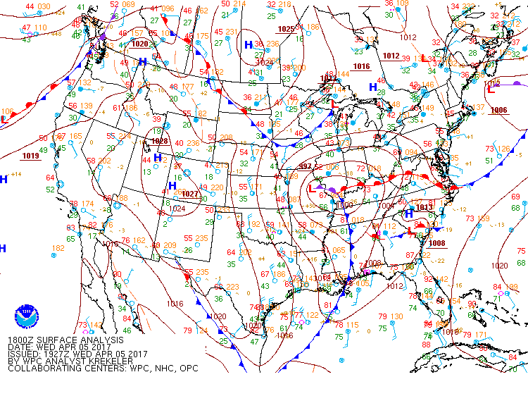
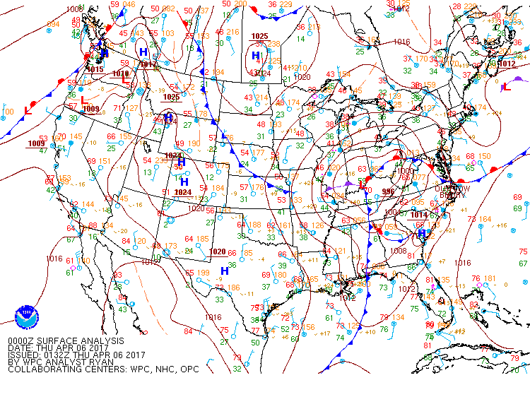
Environment
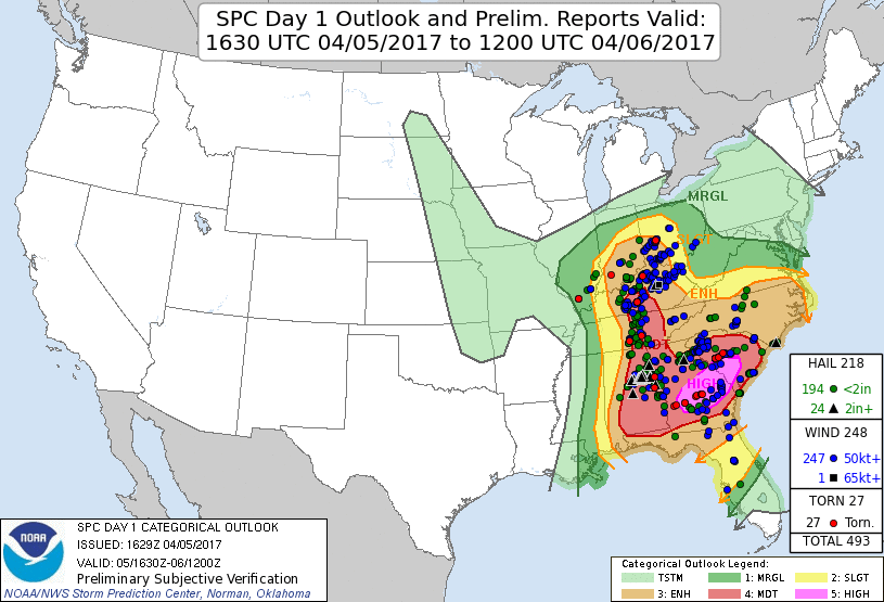
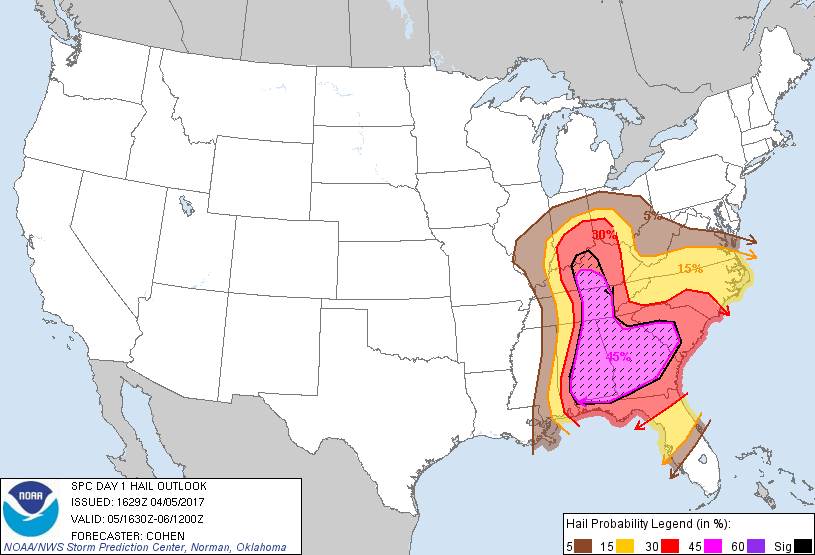
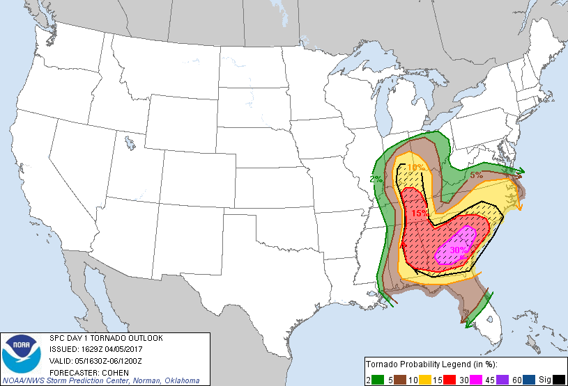
A strong low pressure system tracked from the Missouri Valley into the lower Ohio Valley. The region became moderately unstable by afternoon as dewpoints rose into the mid 50s and temperatures warmed into the upper 70s to lower 80s. The Day 1 Outlook from the Storm Prediction Center (SPC) had south central Kentucky in a Moderate Risk for severe weather and the rest of central KY and southern IN in an Enhanced Risk.
 |
 |
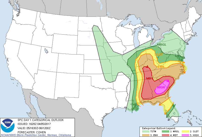 |
| 18Z Surface analysis from WPC | 00Z Surface Analysis from WPC | SPC Day 1 Outlook - 1630Z Update |
 |
 |
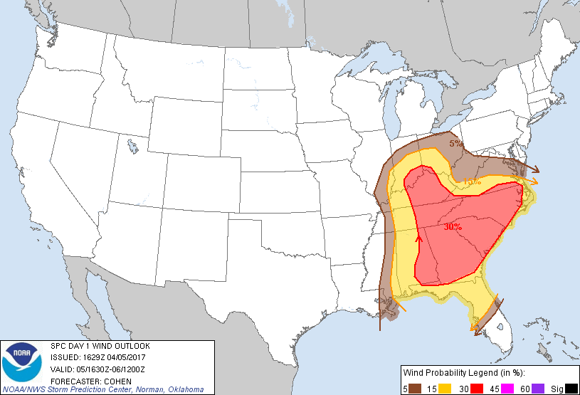 |
| SPC Day 1 Hail probability outlook - 1630Z Update | SPC Day 1 Tornado probability outlook - 1630Z Update | SPC Day 1 Wind probability outlook - 1630Z Update |
 |
Media use of NWS Web News Stories is encouraged! Please acknowledge the NWS as the source of any news information accessed from this site. |
|


 Weather Story
 Weather Map
 Local Radar