Overview
|
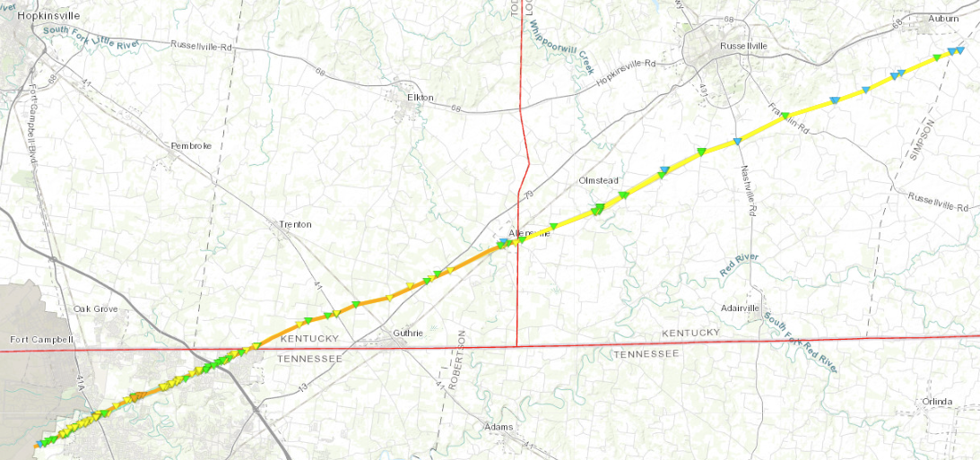
**IMPORTANT: The data in this page is preliminary and may change with storm survey results. ** A strong storm system moved through the eastern half of the United States from December 9th-11th, 2023. The storm system was supported by a broad upper level trough which deepened and amplified over the central and eastern CONUS on December 9th. At the surface, a cold front over the Mississippi Valley on the morning of the 9th gradually moved eastward across Kentucky and Tennessee through the afternoon and evening hours. Ahead of the cold front, low level warm and humid air from the Gulf of America was lifted northward into Middle Tennessee and South Central Kentucky, which when combined with approaching cold air in the mid-levels of the atmosphere, provided enough instability to develop showers and thunderstorms in the pre-frontal environment during the afternoon and evening hours on December 9th. Although instability was an important ingredient for the development of thunderstorms, the amount of vertical wind shear in the atmosphere was the key factor that gave storms the potential to become strong and severe. While winds near the ground ranged from 10 to 15 mph out of the south and southeast, winds 4000-5000 feet off the ground were 45 to 55 mph out of the southwest. This combination of changing wind direction and increasing wind speed allowed for the development of supercell thunderstorms, which began to form across west and northwest Tennessee just after noon. Storms continued to increase in intensity during the early afternoon hours, with one particular supercell west of Clarksville, Tennessee becoming the primary storm of concern for our area. A tornado formed near the perimeter of Fort Campbell before moving northeast, producing up to EF-3 damage in northern Montgomery County, TN. The cell then crossed into Kentucky in southern Todd County, where it was on the ground for over 13 miles, producing up to EF-2 damage. The tornado continued into the NWS Louisville County Warning Area near the community of Allensville on the Todd/Logan County line. In Logan County, the tornado remained on the ground for over 22 miles, producing up to EF-2 damage with maximum estimated winds of 115 mph. The tornado barely crossed into far northwestern Simpson County before lifting about 2 miles southeast of Auburn. However, rotation just off the ground within the mesocyclone remained strong, with funnel clouds being observed as the storm passed through extreme northwestern Simpson County and into southwestern Warren County. Ultimately, a second tornado from the same storm touched down on the south side of Bowling Green, producing up to EF-1 damage with maximum estimated winds of 90 mph over a path of around two and a quarter miles. Later in the evening, a third tornado also touched down in far northern Clay county Tennessee and then moved across the state line into Monroe county Kentucky. This brief EF-1 tornado did most of its damage near the Harlan Crossroads community before lifting.
|
Tornadoes:
Interactive Damage Survey Map - Zoom in and click the points to see damage information and pictures. All damage points are preliminary at this time. Performance of this map may be slow due to heavy internet traffic. **Zoom in to see very small, brief tornadoes.**

|
Tornado - 7 miles NW of Clarksville, TN to 2 miles SE of Auburn, KY
|
||||||||||||||||
|
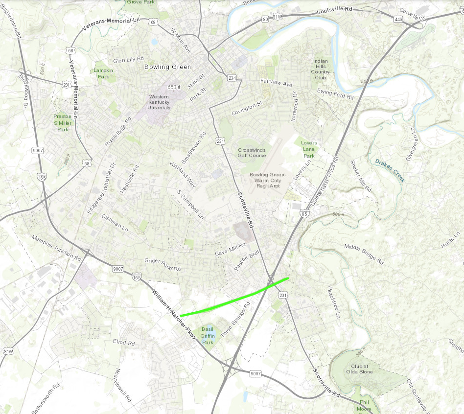
Tornado - Southern Bowling Green
|
||||||||||||||||
|
Tornado - Harlan Crossroads, KY
|
||||||||||||||||
The Enhanced Fujita (EF) Scale classifies tornadoes into the following categories:
| EF0 Weak 65-85 mph |
EF1 Moderate 86-110 mph |
EF2 Significant 111-135 mph |
EF3 Severe 136-165 mph |
EF4 Extreme 166-200 mph |
EF5 Catastrophic 200+ mph |
 |
|||||
Photos & Video
Photos
 |
 |
 |
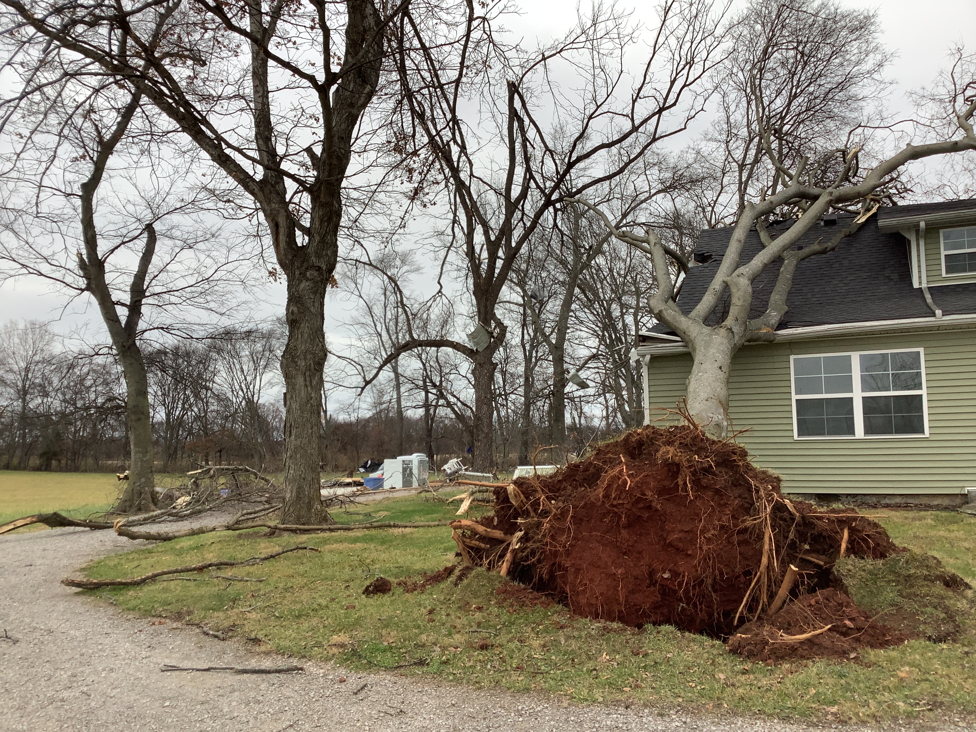 |
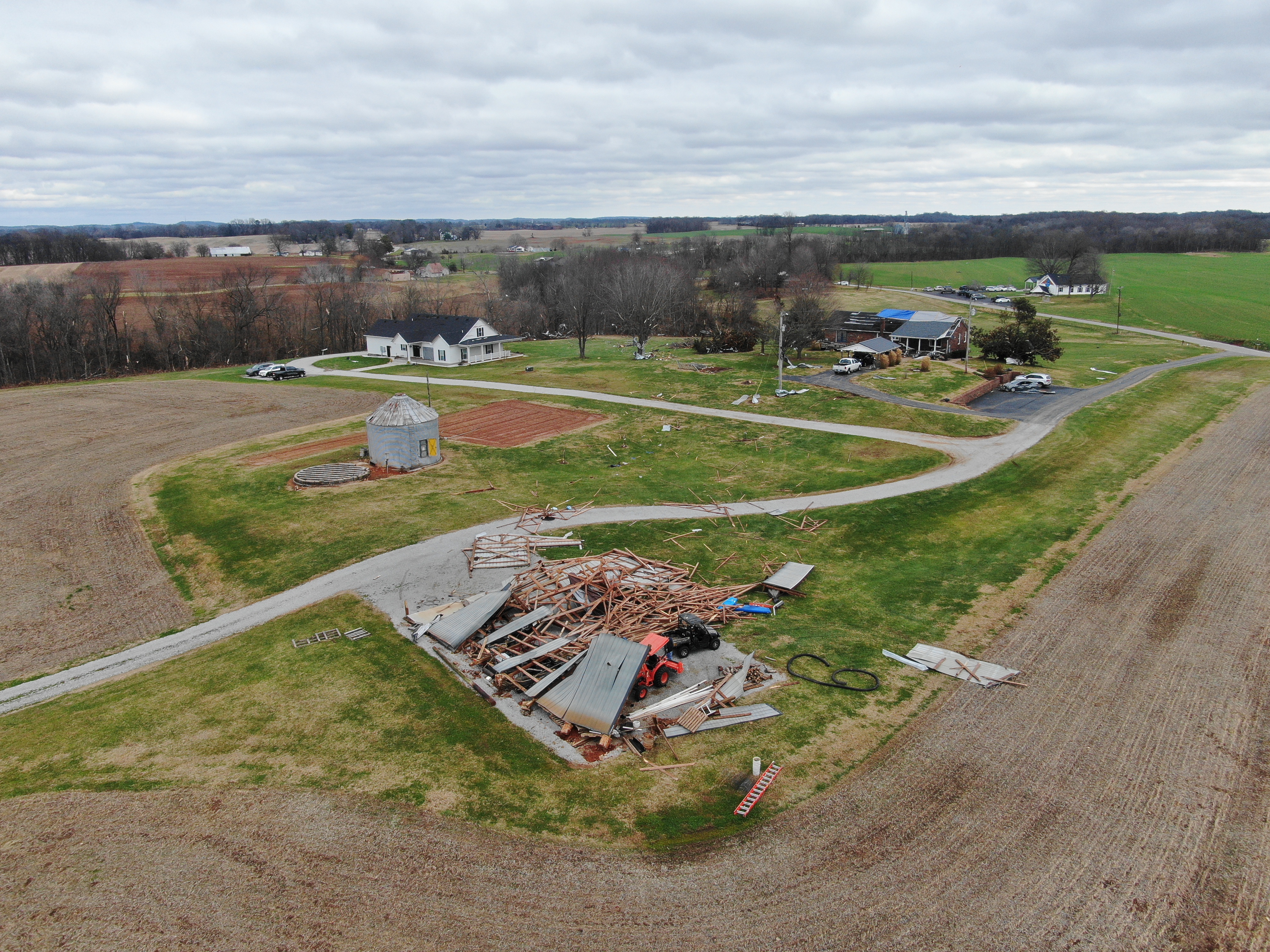
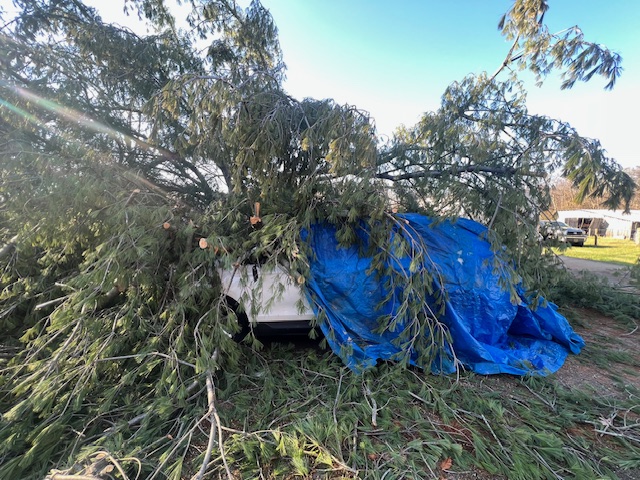
| Aerial photo of a collapsed barn in the Lickskillet community in Logan County | Aerial photo of a house with partial roof loss southwest of Russellville | Tree blown onto a vehicle south of Bowling Green | Tree blown onto a house south of Bowling Green |
Video
| NWS Louisville Aerial Video of Tornado Damage south of Russellville, KY. |
Radar
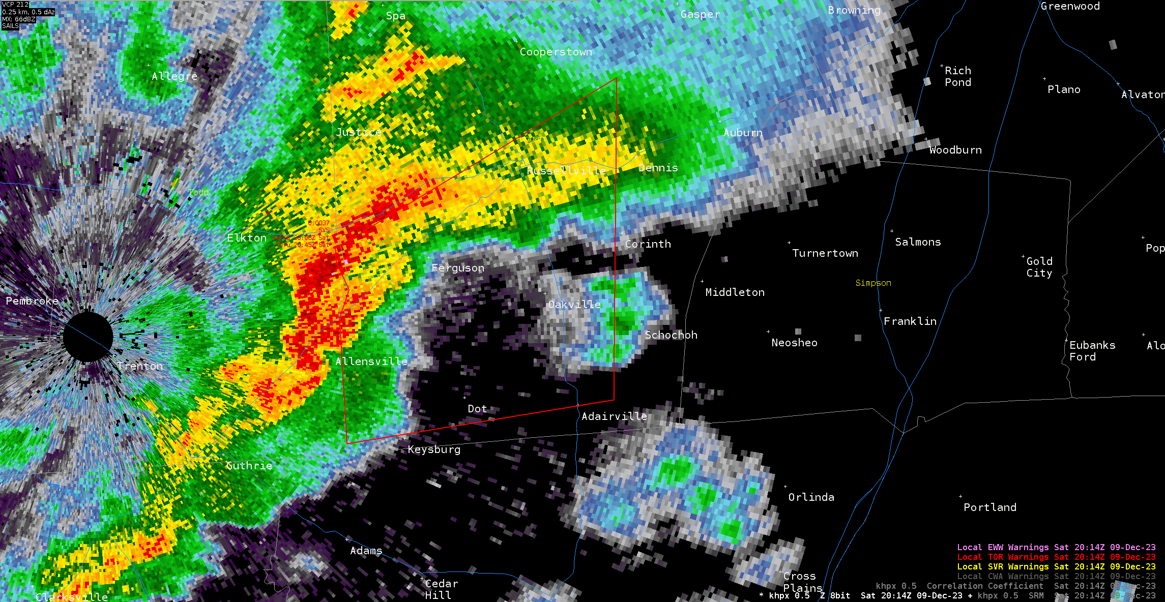
Logan County EF-2
 |
 |
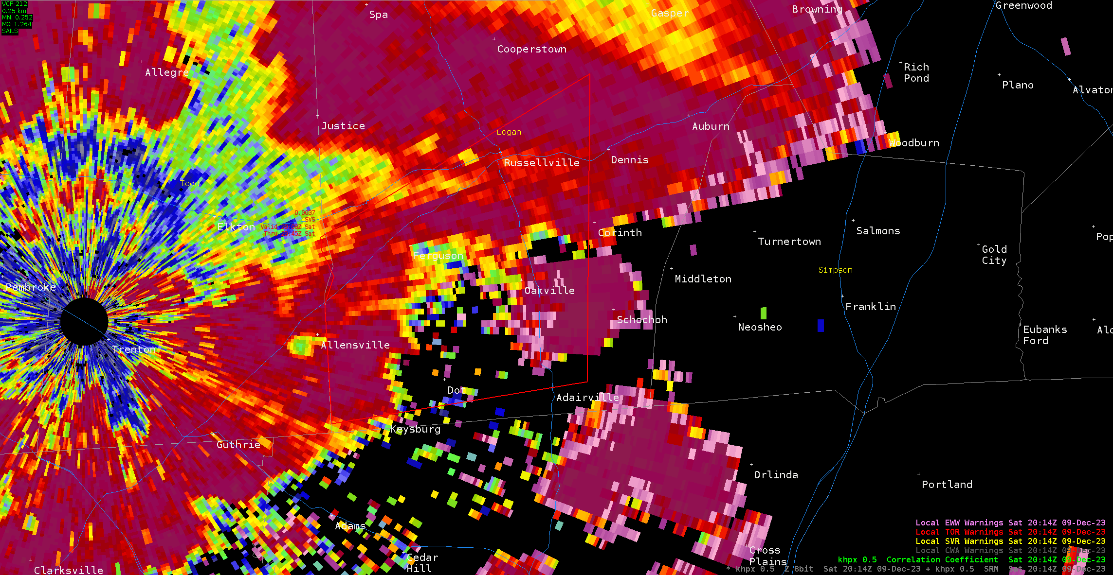 |
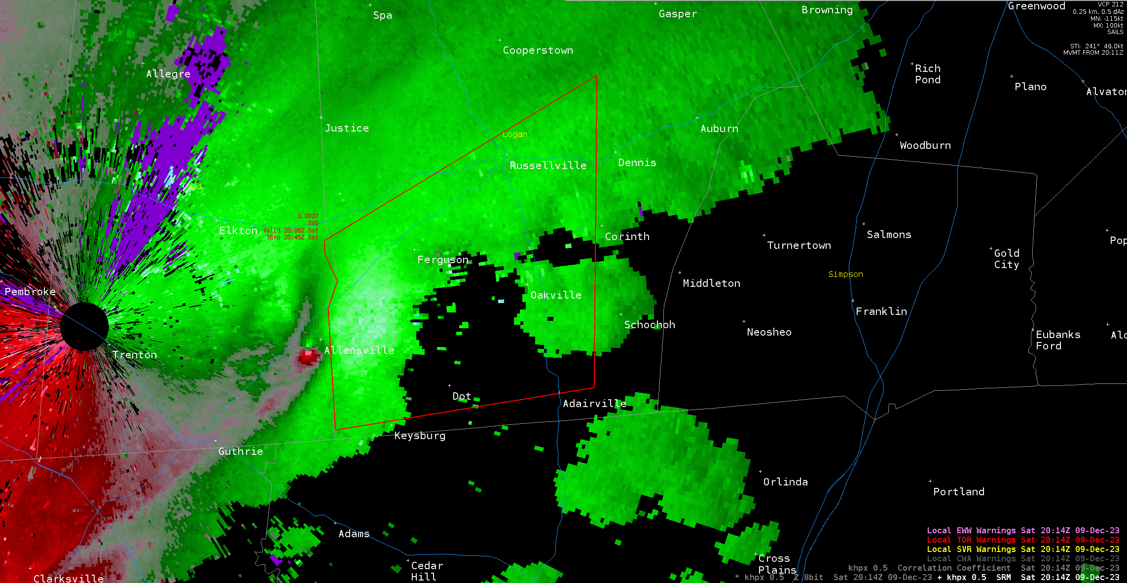
| KHPX Reflectivity at 2:14 pm CST, 12/09/2023. At this time, the tornado is located on top of the Allensville community and is about to enter Logan County. | KHPX Storm Relative Velocity at 2:14 pm CST, 12/09/2023. | KHPX Correlation Coefficient at 2:14 pm CST, 12/09/2023. |
 |
 |
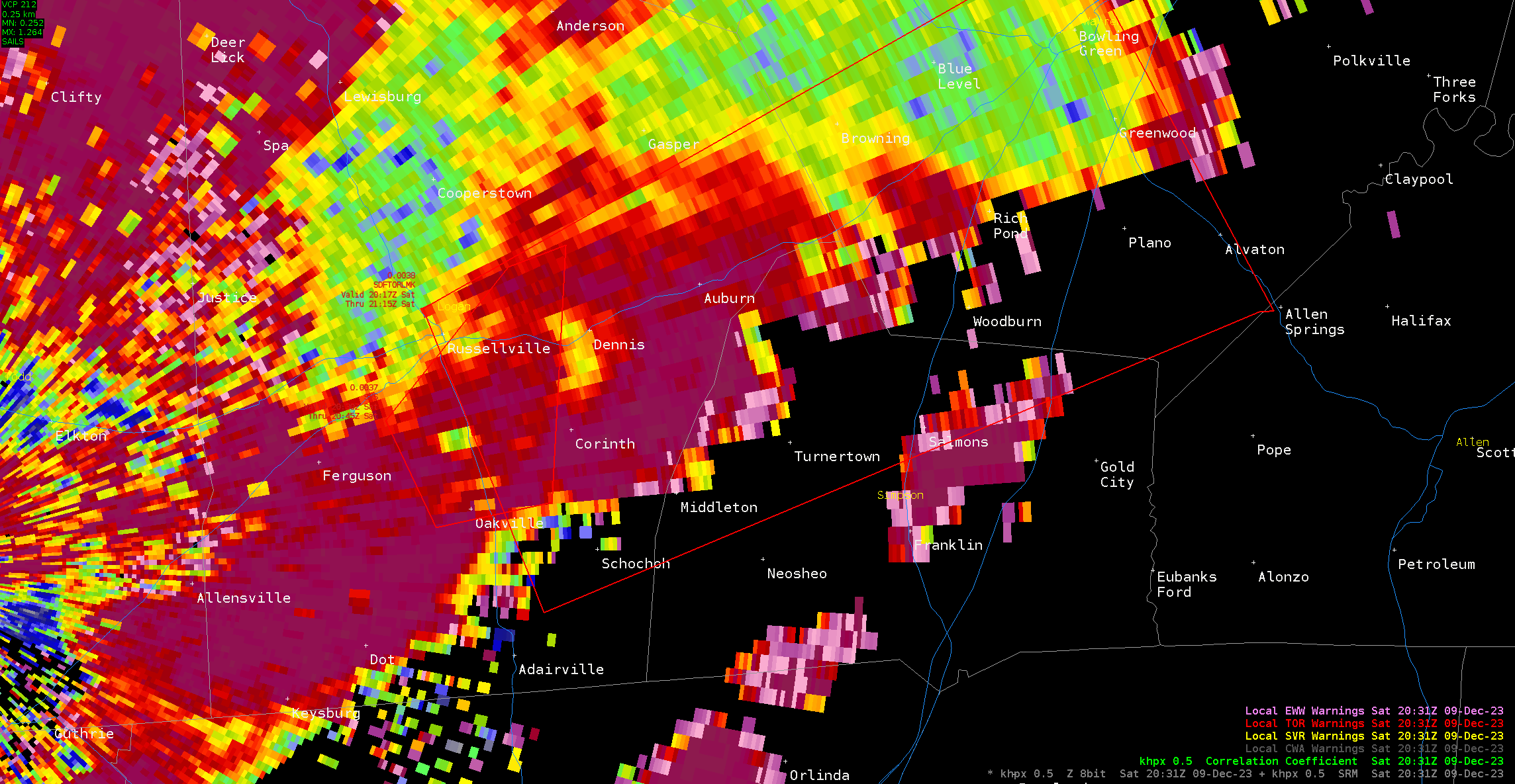 |
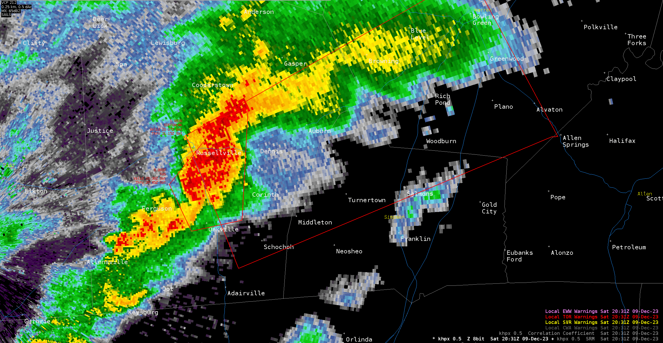
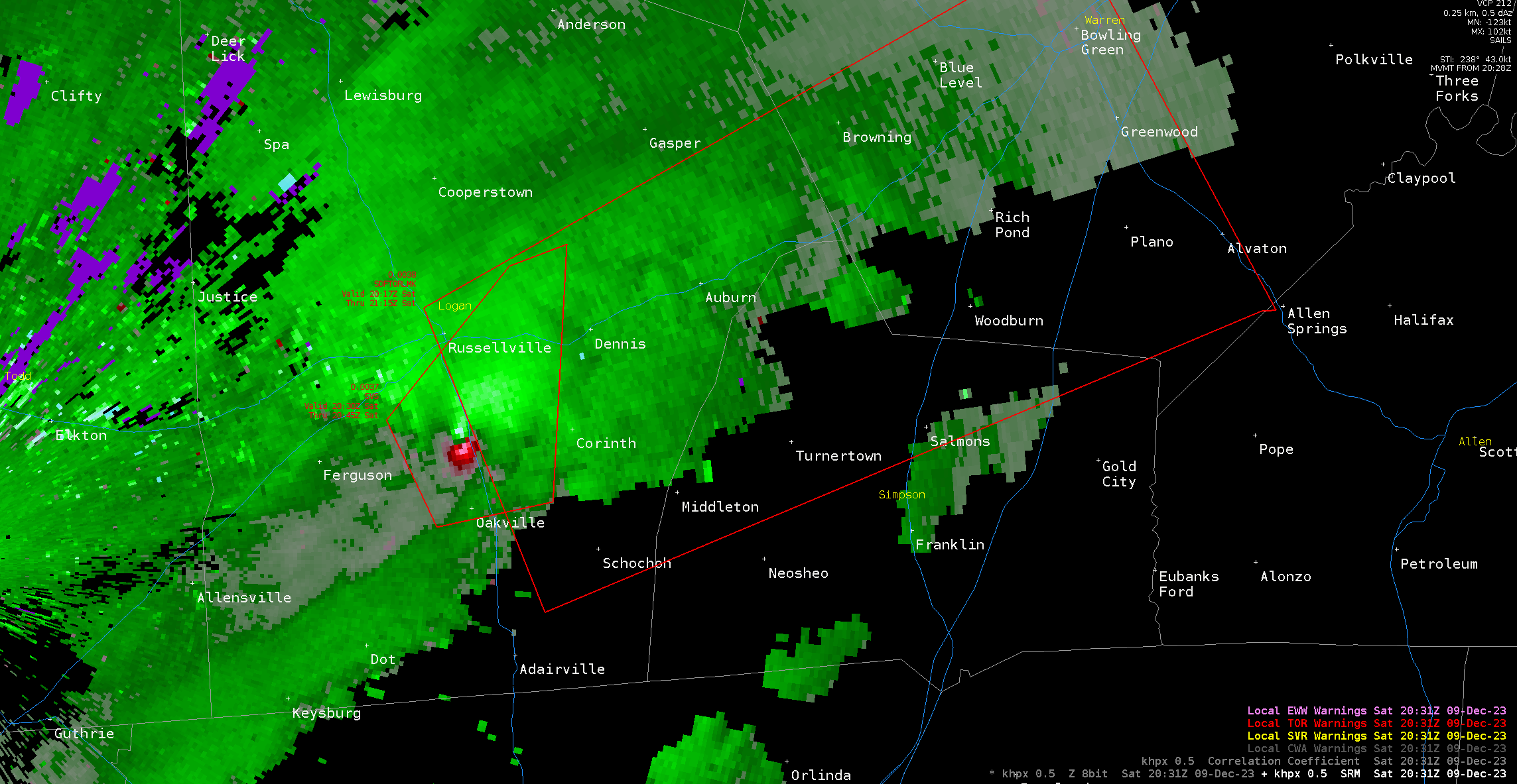
| KHPX Reflectivity at 2:31 pm CST, 12/09/2023. At this time, the tornado is about to cross US Route 431 (Nashville Road) a few miles south of Russellville. | KHPX Storm Relative Velocity at 2:31 pm CST, 12/09/2023. | KHPX Correlation Coefficient at 2:31 pm CST, 12/09/2023. |
Warren County EF-1
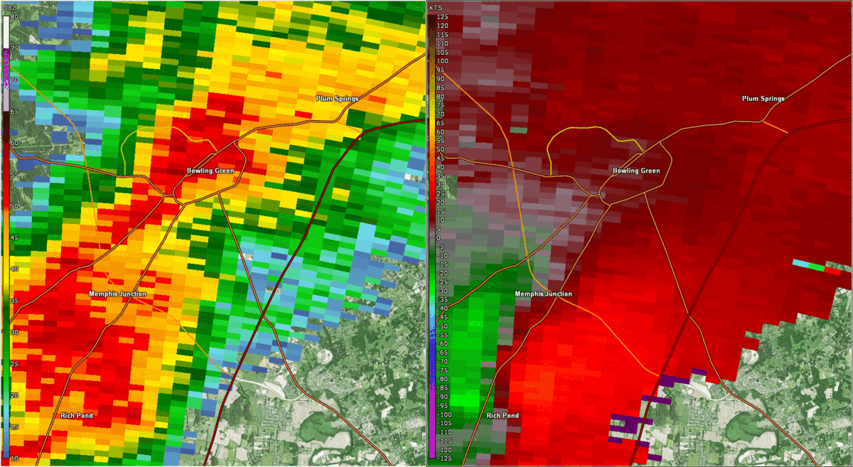 |
| KOHX Reflectivity (left) and Storm Relative Velocity (right) looped from 3:03 p.m. CST until 3:16 p.m. CST, 12/09/2023. An EF-1 tornado touched down on the south side of Bowling Green around 3:07 p.m. CST, remaining on the ground intermittently until lifting at 3:13 p.m. CST. |
Monroe County EF-1
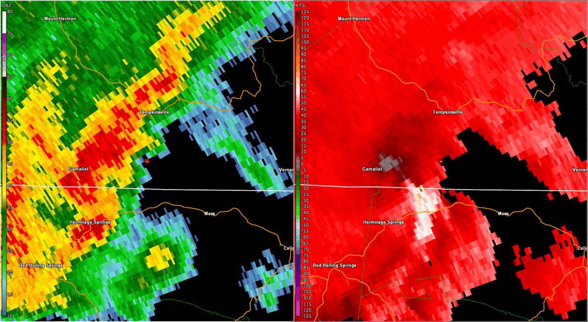 |
| KOHX Reflectivity (left) and Storm Relative Velocity (right) looped from 6:04 p.m. CST until 6:17 p.m. CST, 12/09/2023. An EF-1 tornado touched down near the KY/TN border and moved NE toward the Harlan Crossroads area east of Gamaliel, KY and south of Tompkinsville, KY. The most significant damage with winds around 90 mph was done around Harlan Crossroads. |
Storm Reports
NWUS53 KLMK 201810
LSRLMK

Preliminary Local Storm Report...Summary
National Weather Service Louisville KY
110 PM EST Wed Dec 20 2023

..TIME...   ...EVENT...      ...CITY LOCATION...     ...LAT.LON...
..DATE...   ....MAG....      ..COUNTY LOCATION..ST.. ...SOURCE....
            ..REMARKS..

0405 PM     Tstm Wnd Dmg     1 ENE Rich Pond         36.91N 86.48W
12/09/2023                   Warren             KY   Law Enforcement

            Warren County Law Enforcement found isolated
            tree damage near the intersection of Dillard
            Rd and Spindletop Ct as well as a garage
            door with an inward dent in it. Another tree
            was down along Crimson Lane. Straight line
            wind estimates are 75-85 mph based on
            imagery for these points. Timing based on
            OHX radar.

0407 PM     Tornado          3 ENE Rich Pond         36.92N 86.45W
12/09/2023                   Warren             KY   NWS Storm Survey

            NWS storm damage assessment survey in Warren
            County on the south side of Bowling Green
            found an EF-1 tornado with a path length of
            2.24 miles, max width of 125 yards, and
            estimated peak winds of 90 mph. The tornado
            touched down at 3:07 pm CST and lifted at
            3:13 pm CST. Please see the associated PNS
            for the full details.

0410 PM     Funnel Cloud     2 NNW Plano             36.91N 86.43W
12/09/2023                   Warren             KY   Public

            Photo posted on social media of a funnel
            cloud at the Interstate 65 and Interstate
            165 interchange south of Bowling Green.

0413 PM     Tstm Wnd Dmg     3 SSE Bowling Green     36.94N 86.41W
12/09/2023                   Warren             KY   Emergency Mngr

            Roof damage to hotel.

0349 PM     Tornado          2 SSE Auburn            36.84N 86.68W
12/09/2023                   Simpson            KY   Law Enforcement

            Final extension to the long-track tornado
            affecting north central Tennessee southern
            Todd, Logan and ending in far NW Simpson
            county. The last point had some roof damage
            to a large barn along J Wilson Rd. The
            Simpson County portion of the tornado had
            EF-0 damage, with peak winds estimated at
            80-85 mph. Thanks to the Auburn Police and
            to citizens along the path who sent us
            imagery to help with the extension.

0354 PM     Tstm Wnd Dmg     3 SE South Union        36.86N 86.61W
12/09/2023                   Simpson            KY   Law Enforcement

            Simpson County law enforcement found barn
            with minor roof damage near the border of
            Warren and Simpson counties, along Harvey
            Robertson Rd, near Hardison Rd.
            Straight-lined winds estimated at 80 mph
            with this damage. Timing based on OHX radar.

0707 PM     Tornado          4 ESE Gamaliel          36.62N 85.72W
12/09/2023                   Monroe             KY   NWS Storm Survey

            NWS Nashville surveyed a brief EF-1 tornado
            that touched down just south of the Kentucky
            border in Clay County where it blew down a
            few trees on Barber Shop Road (EF-0). The
            tornado intensified to EF-1 as it moved
            northeast into Kentucky and caused
            significant roof and siding damage to
            several chicken barns on Harlans Crossroads.
            A home also lost its porch and part of its
            roof on Red Hill-Beech Grove Road. A few
            more trees were blown down west of Beech
            Groves-Boles Road before the tornado lifted.

0315 PM     Tornado          3 SW Olmstead           36.71N 87.06W
12/09/2023                   Logan              KY   NWS Storm Survey

            The National Weather Service in Louisville
            conducted a storm damage assessment survey
            in Logan County Kentucky. This survey
            covered the final portion of a long track
            EF3 tornado that touched down in Montgomery
            County Tennessee. Storm damage was
            consistent with EF2 tornado damage and
            estimated peak wind speeds of 115 mph in
            Logan County. The tornado tracked 18.23
            miles across Logan County before
            dissipating. The maximum path width was 250
            yards. Please see the associated Public
            Information Statement for additional
            information.

0318 PM     Tstm Wnd Dmg     1 ENE Olmstead          36.75N 87.00W
12/09/2023                   Logan              KY   911 Call Center

            Dispatch reports several houses and barns
            damaged, mainly near Olmstead, Kentucky.

0648 PM     Tstm Wnd Dmg     1 SE Munfordville       37.27N 85.89W
12/09/2023                   Hart               KY   Emergency Mngr

            Tree down on a power line.

0729 PM     Tstm Wnd Dmg     6 NW Peytonsburg        36.69N 85.46W
12/09/2023                   Cumberland         KY   Emergency Mngr

            Delayed report. Equipment shed flipped over
            from thunderstorm winds. Time estimated by
            radar.


&&

$$
Environment
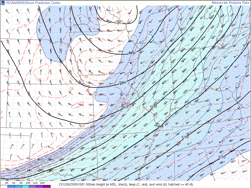
A strong storm system moved through the eastern half of the United States from December 9th-11th, 2023. The storm system was supported by a broad upper level trough which deepened and amplified over the central and eastern CONUS on December 9th. At the surface, a cold front over the Mississippi Valley on the morning of the 9th gradually moved eastward across Kentucky and Tennessee through the afternoon and evening hours. Ahead of the cold front, low level warm and humid air from the Gulf of America was lifted northward into Middle Tennessee and South Central Kentucky, which when combined with approaching cold air in the mid-levels of the atmosphere, provided enough instability to develop showers and thunderstorms in the pre-frontal environment during the afternoon and evening hours on December 9th.
 |
 |
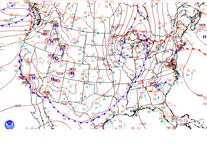 |
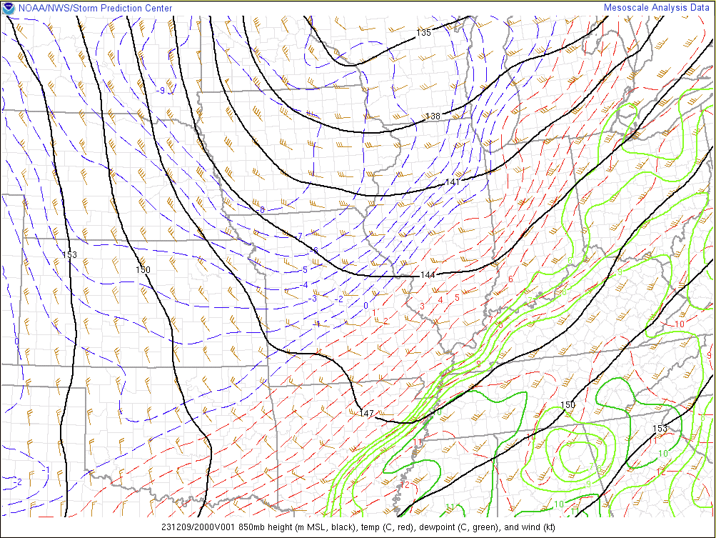
| Figure 1: 20z 500mb Analysis | Figure 2: 20z 850mb Analysis | Figure 3: 21z WPC Surface Analysis |
Although instability was an important ingredient for the development of thunderstorms, the amount of vertical wind shear in the atmosphere was the key factor that gave storms the potential to become strong and severe. While winds near the ground ranged from 10 to 15 mph out of the south and southeast, winds 4000-5000 feet off the ground were 45 to 55 mph out of the southwest. This combination of changing wind direction and increasing wind speed allowed for the development of supercell thunderstorms, which began to form across west and northwest Tennessee just after noon. Storms continued to increase in intensity during the early afternoon hours, with one particular supercell west of Clarksville, Tennessee becoming the primary storm of concern for our area. A tornado formed near the perimeter of Fort Campbell before moving northeast, producing up to EF-3 damage in northern Montgomery County, TN. The cell then crossed into Kentucky in southern Todd County, where it was on the ground for over 13 miles, producing up to EF-2 damage.
 |
 |
 |
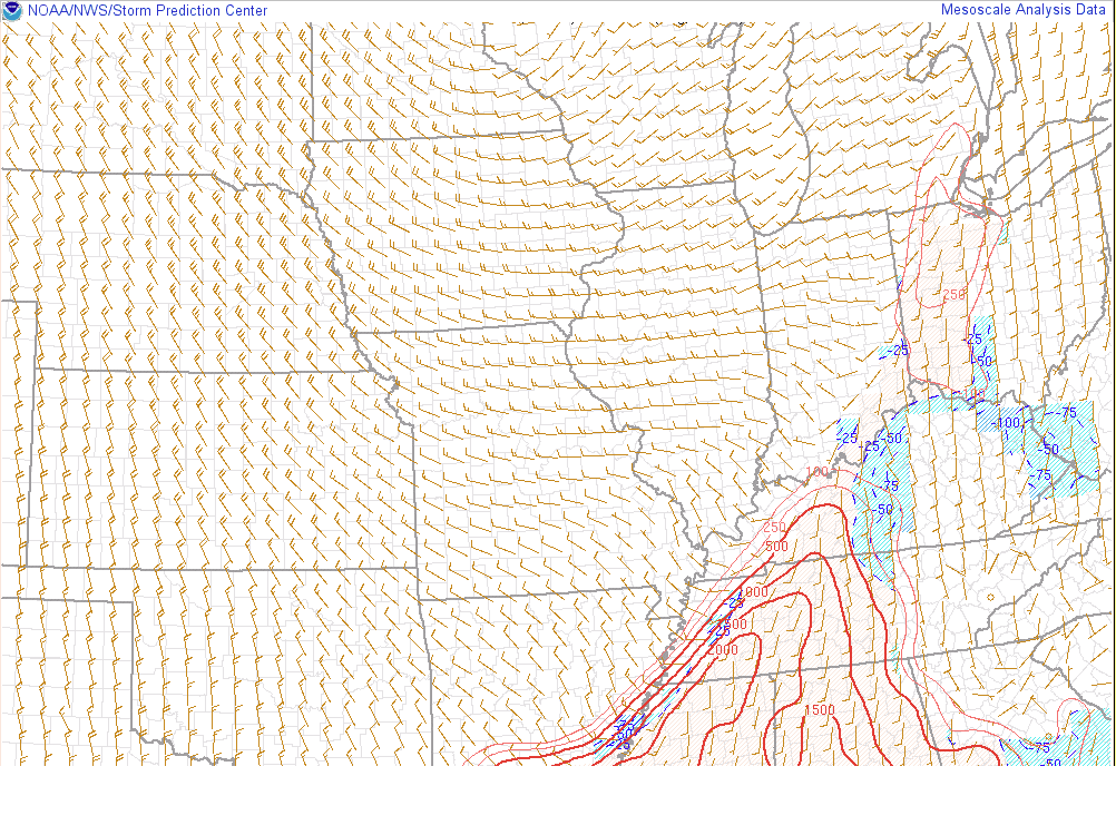
| Figure 4: 20z SBCAPE | Figure 5: 20z Effective Sig Tor | Figure 6: 20z Effective Bulk Shear |
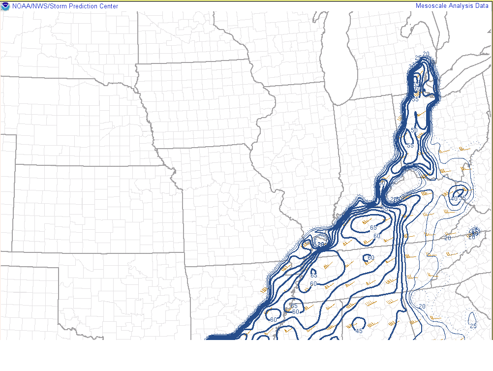
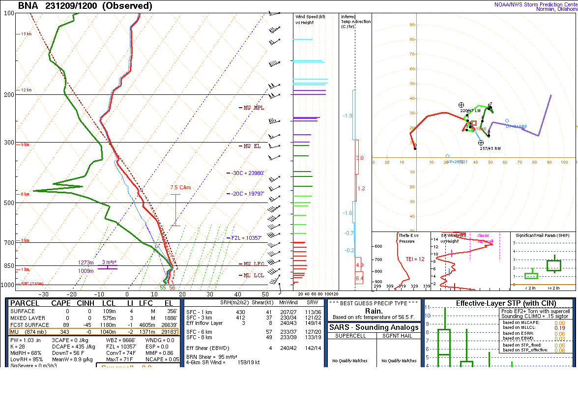
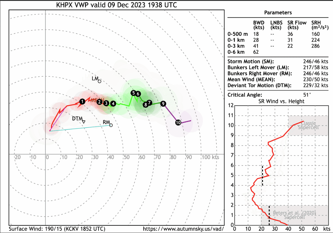
Additional environmental data.
 |
 |
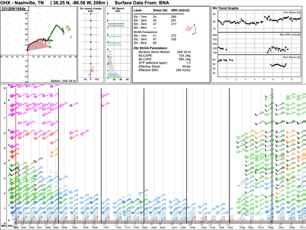 |
| Figure 7: 09.12z BNA Sounding | Figure 8: KHPX VWP at 1938z | Figure 9: KOHX VAD at 1954z |
 |
Media use of NWS Web News Stories is encouraged! Please acknowledge the NWS as the source of any news information accessed from this site. |
|


.png)
 Weather Story
 Weather Map
 Local Radar