Overview
|
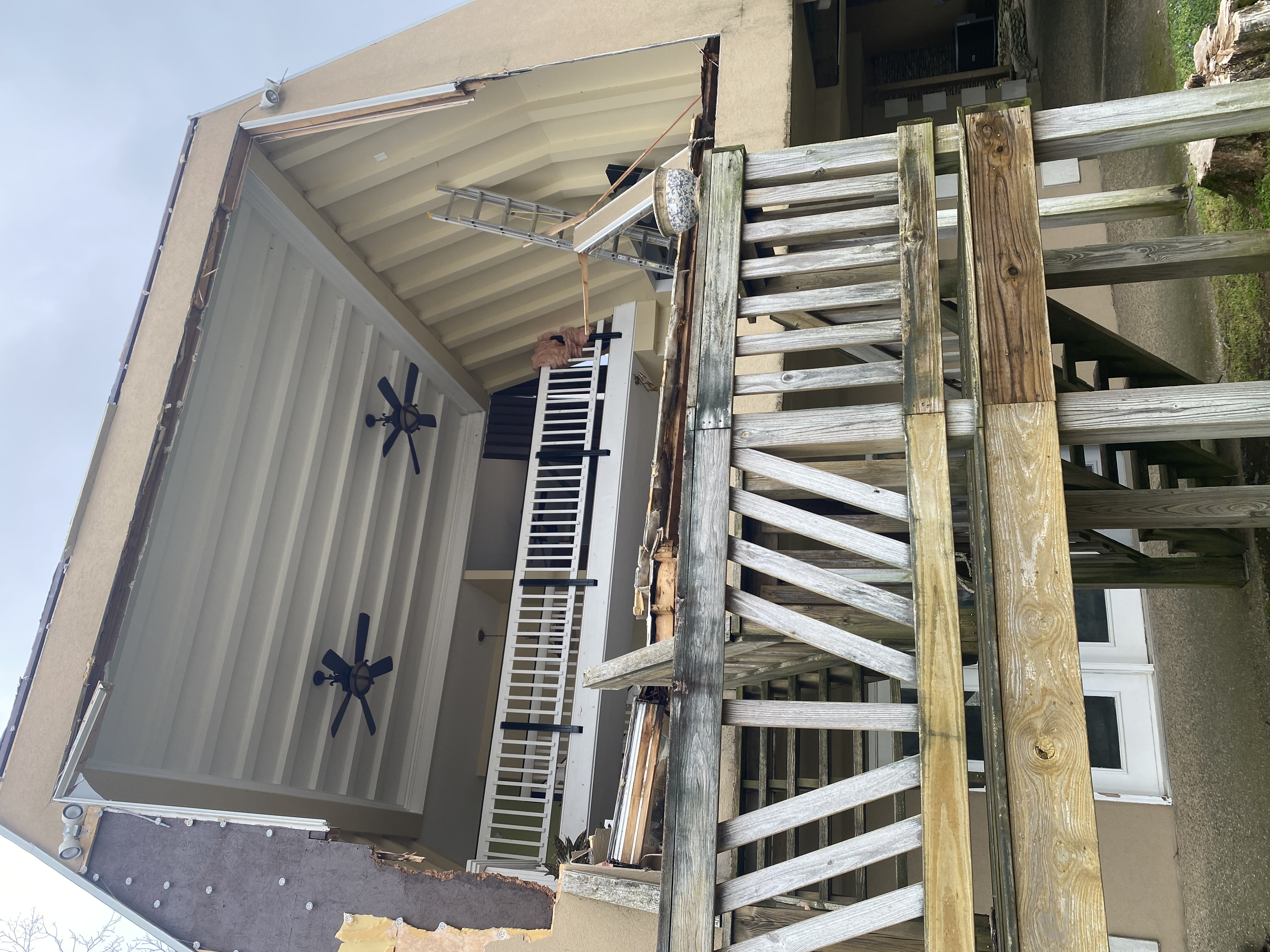
On Tuesday April 2, 2024, a strong low pressure system moved through the region resulting in hail, wind damage, and ten tornadoes.
Have Storm Damage? Know of Some? We want your report.... You can fill out this form it's VERY IMPORTANT we have DATE, Best Guess Time it Occurred and your Location... |
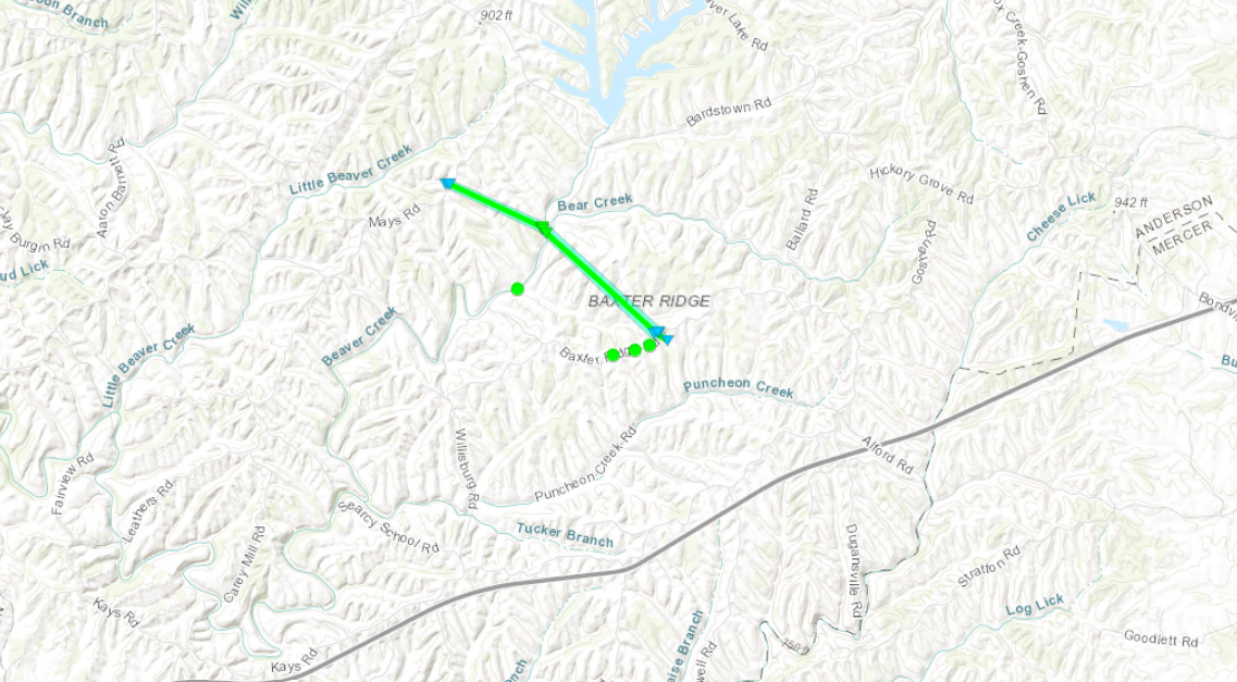
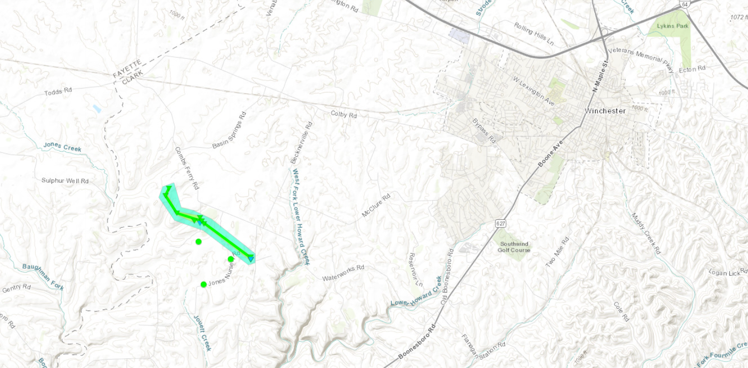
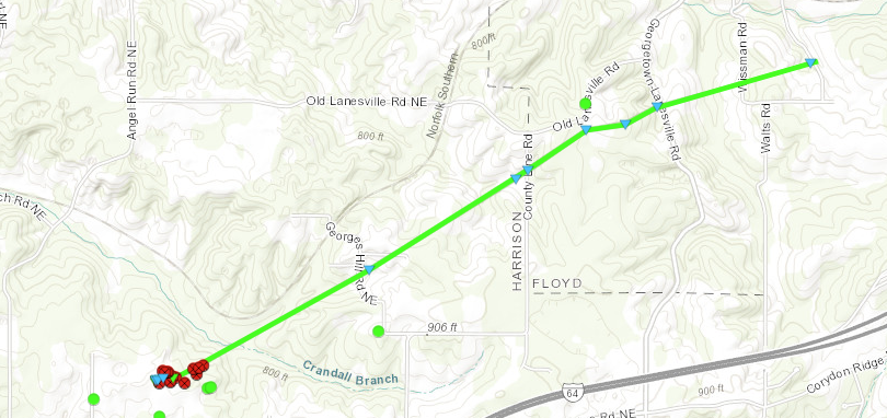
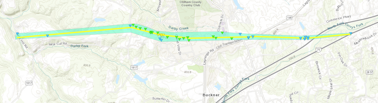
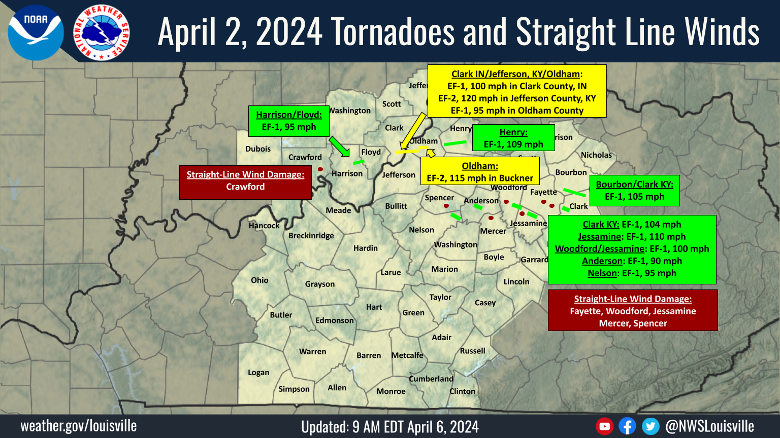 Damage Survey Map |
 |
 |
 |
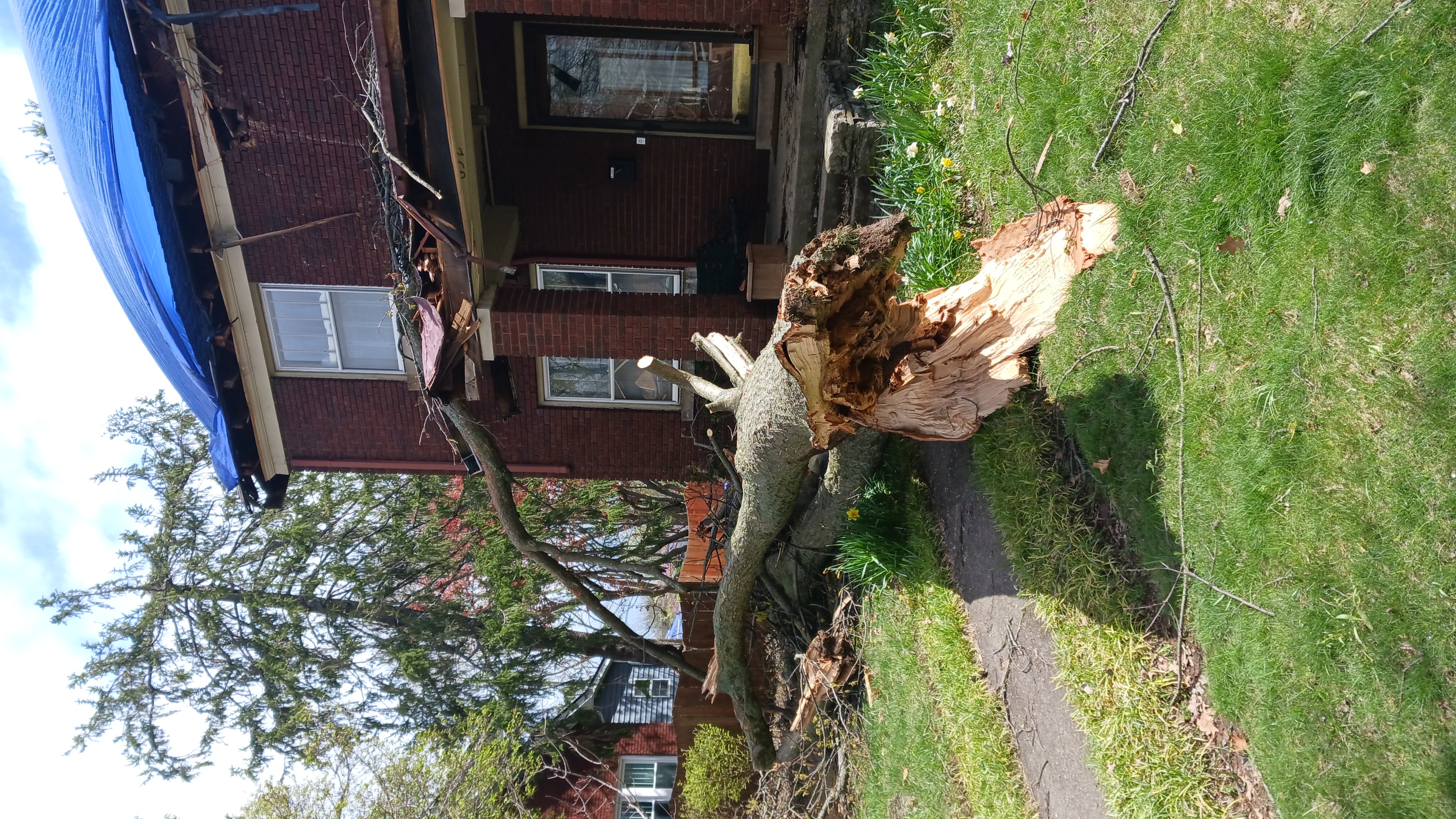
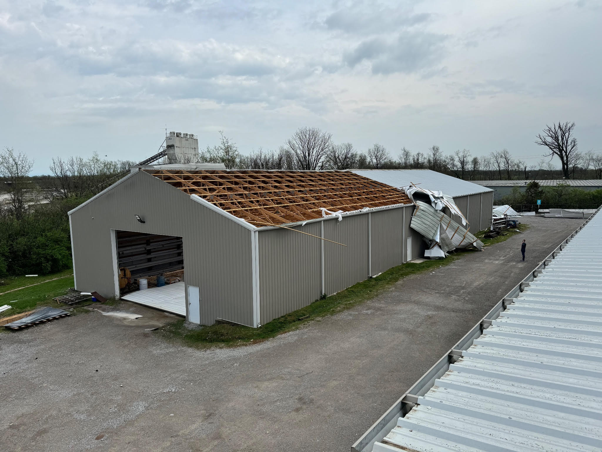
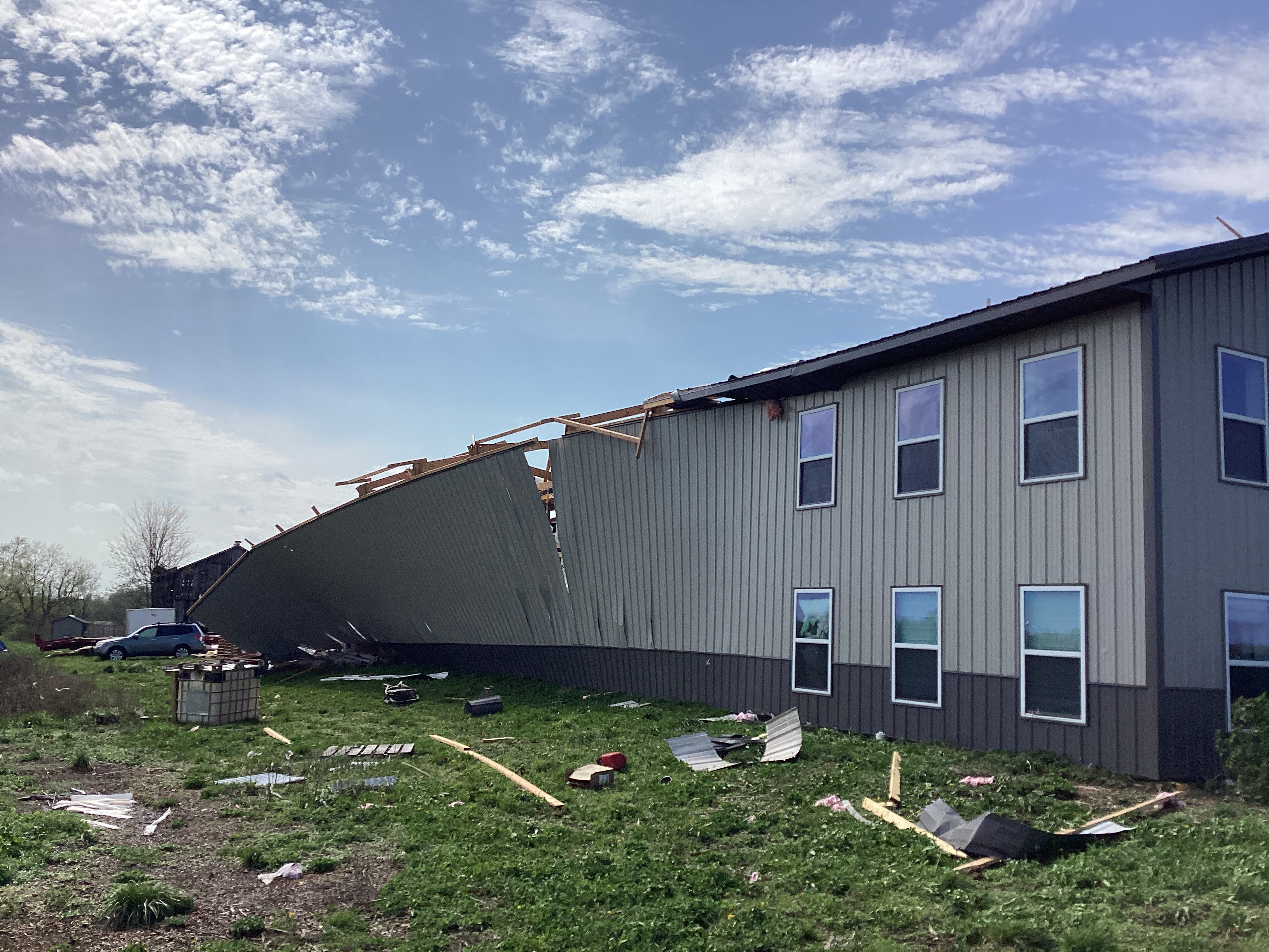
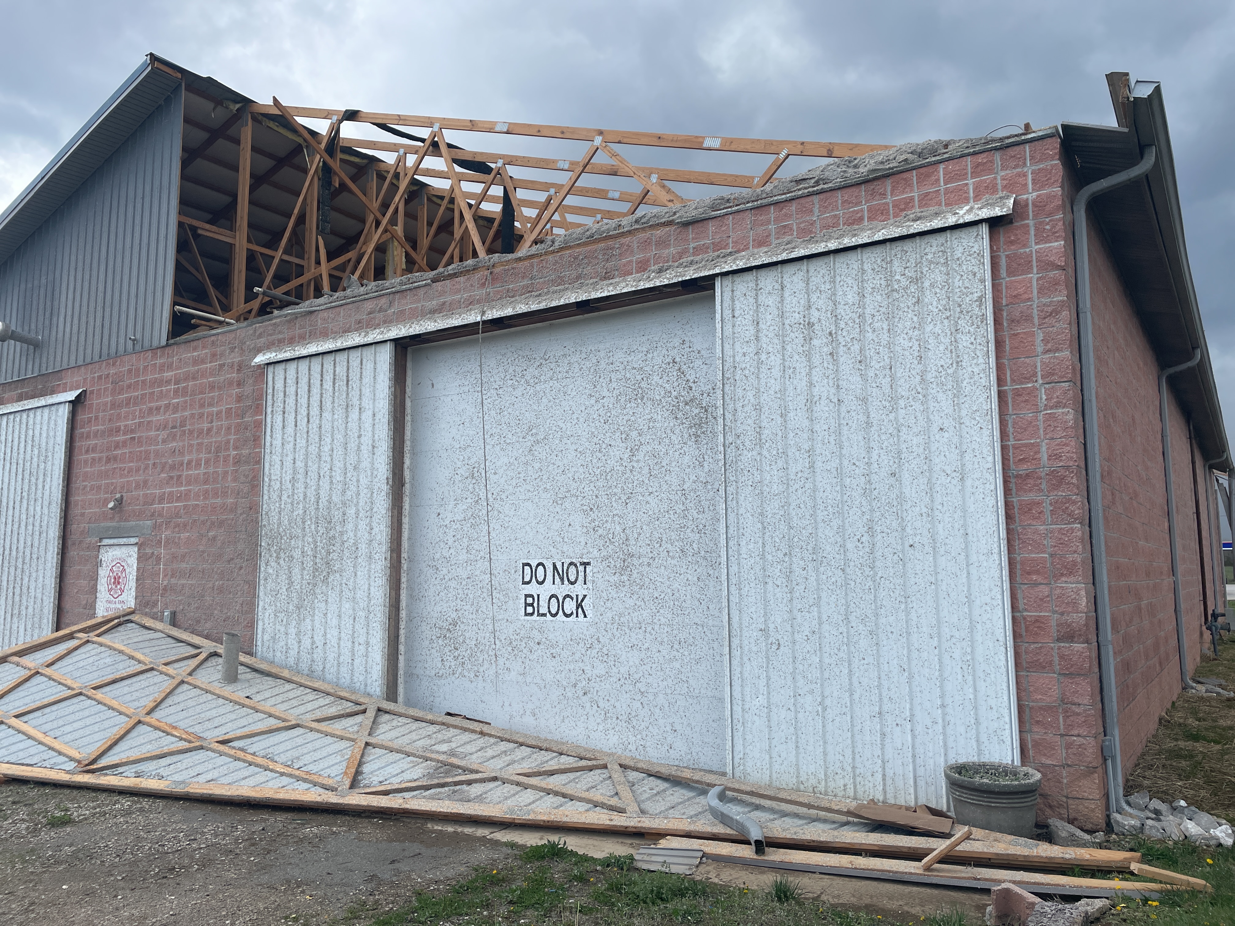
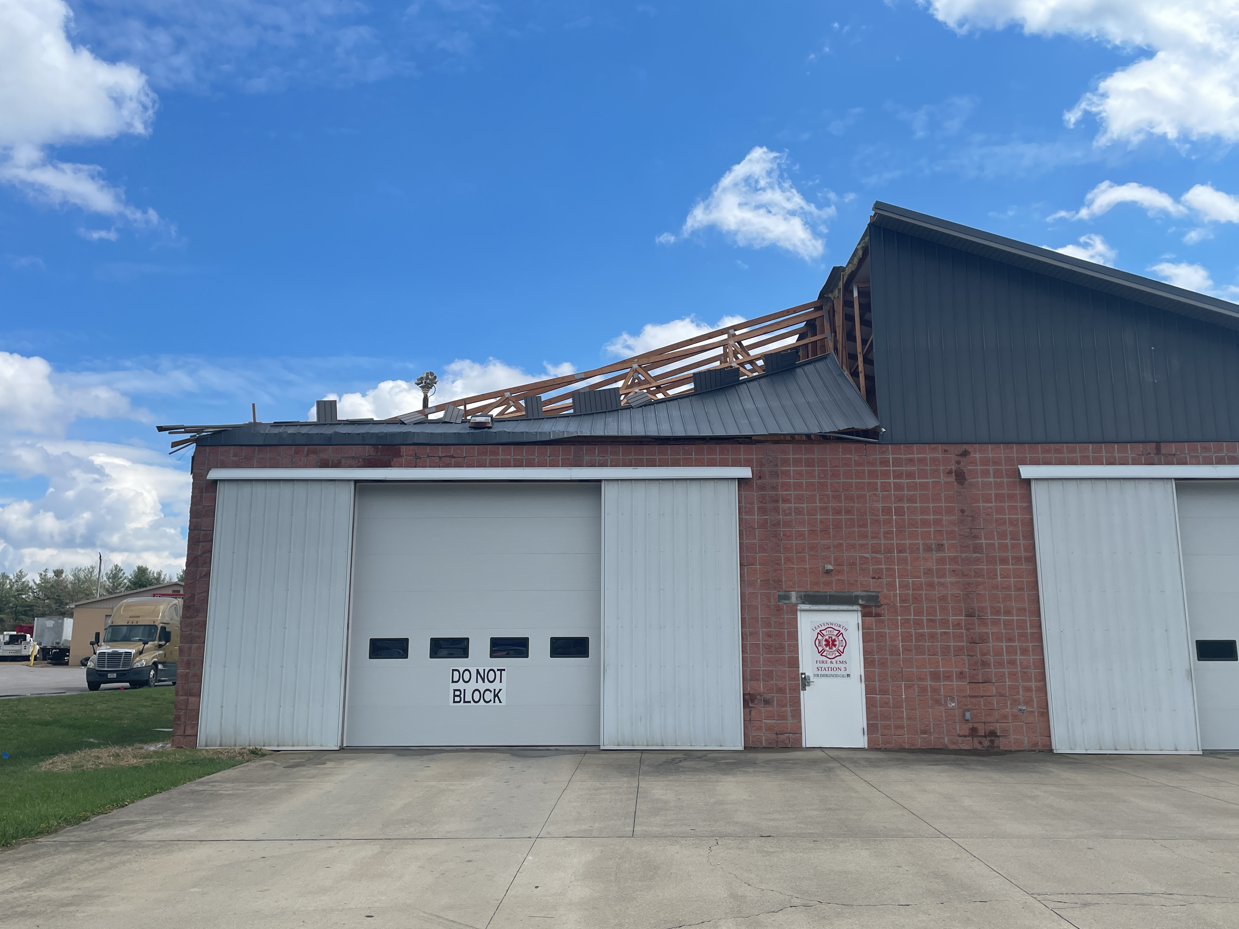
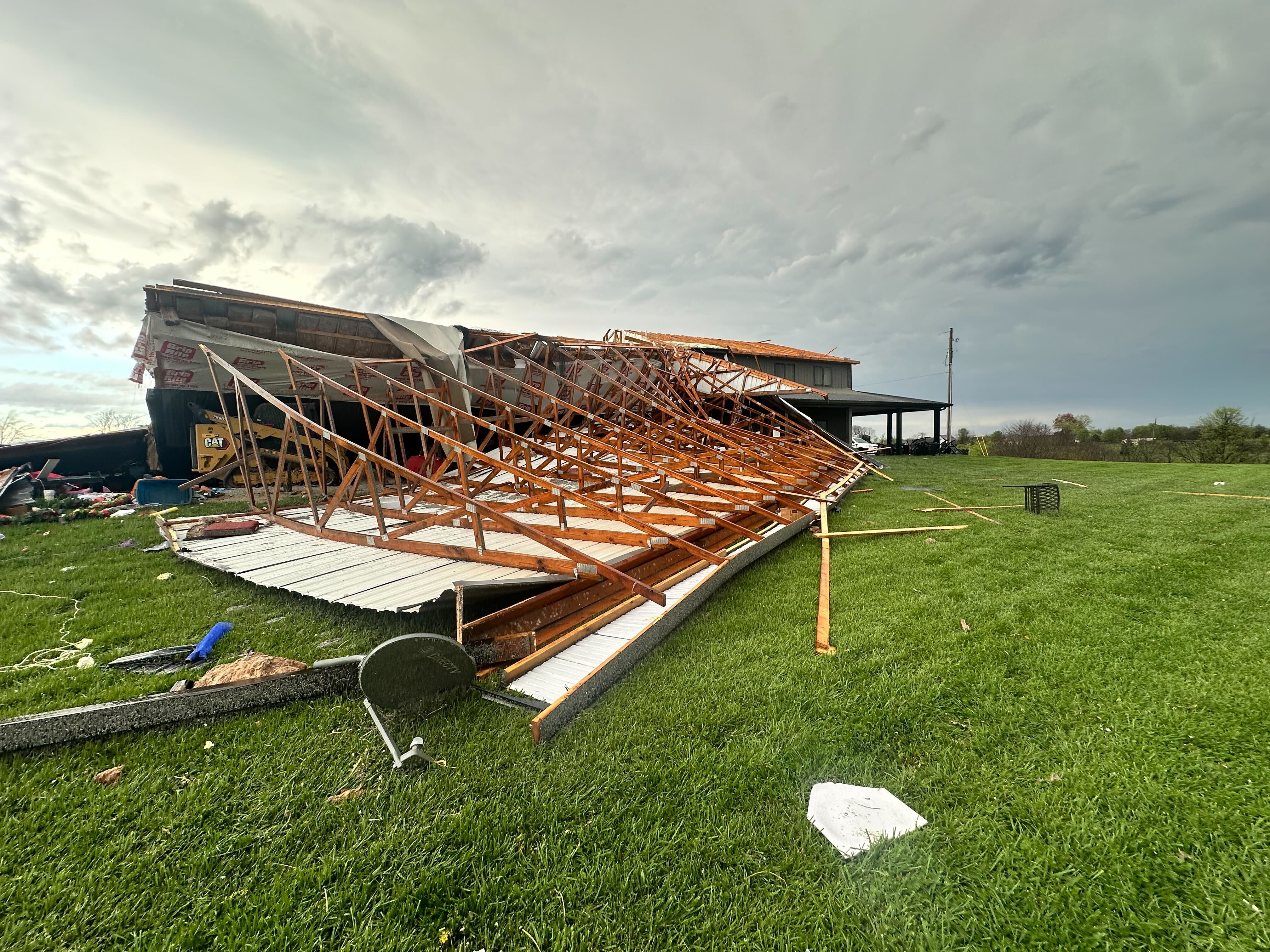
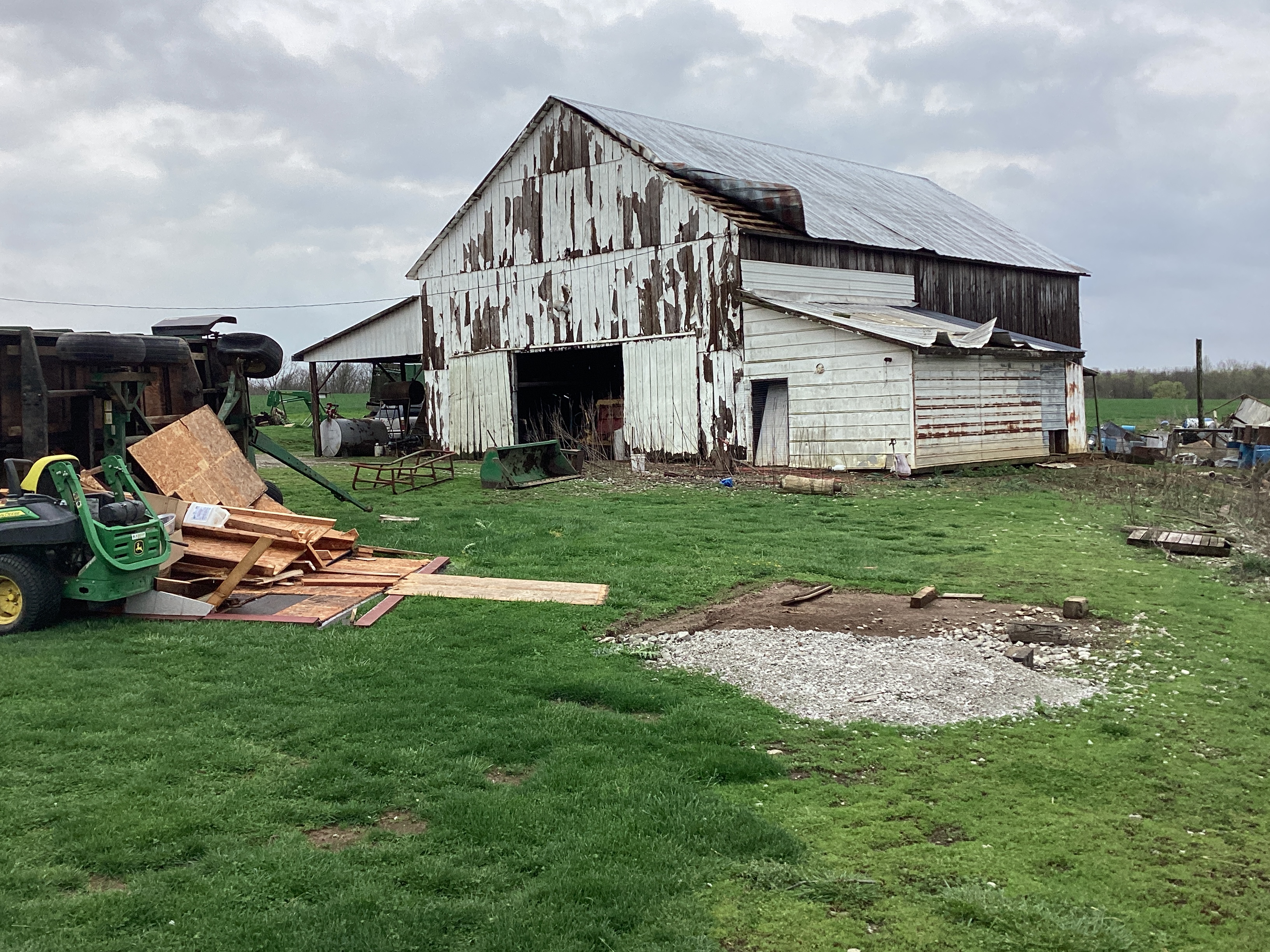
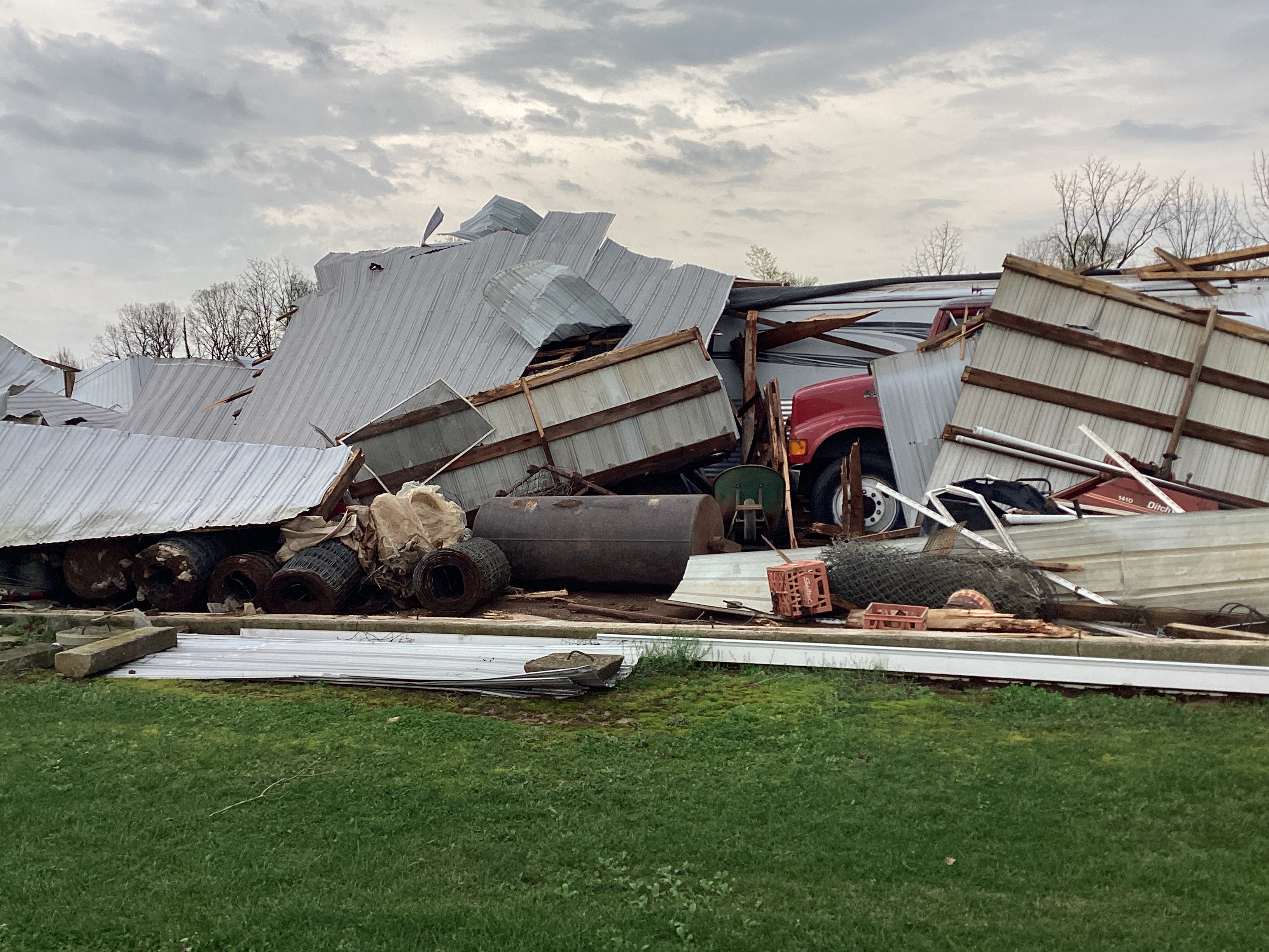
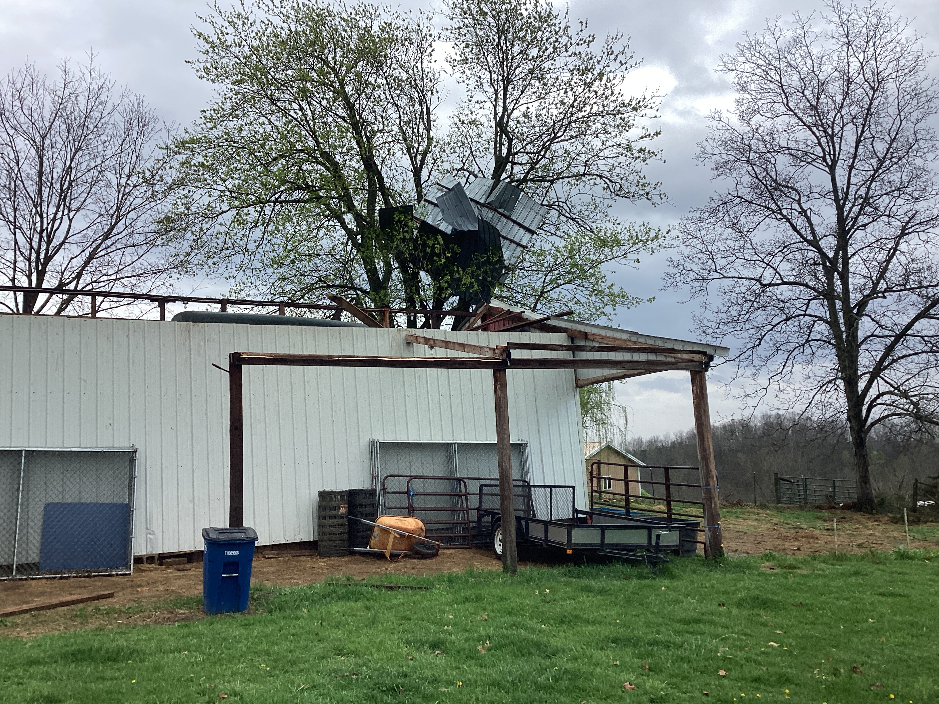
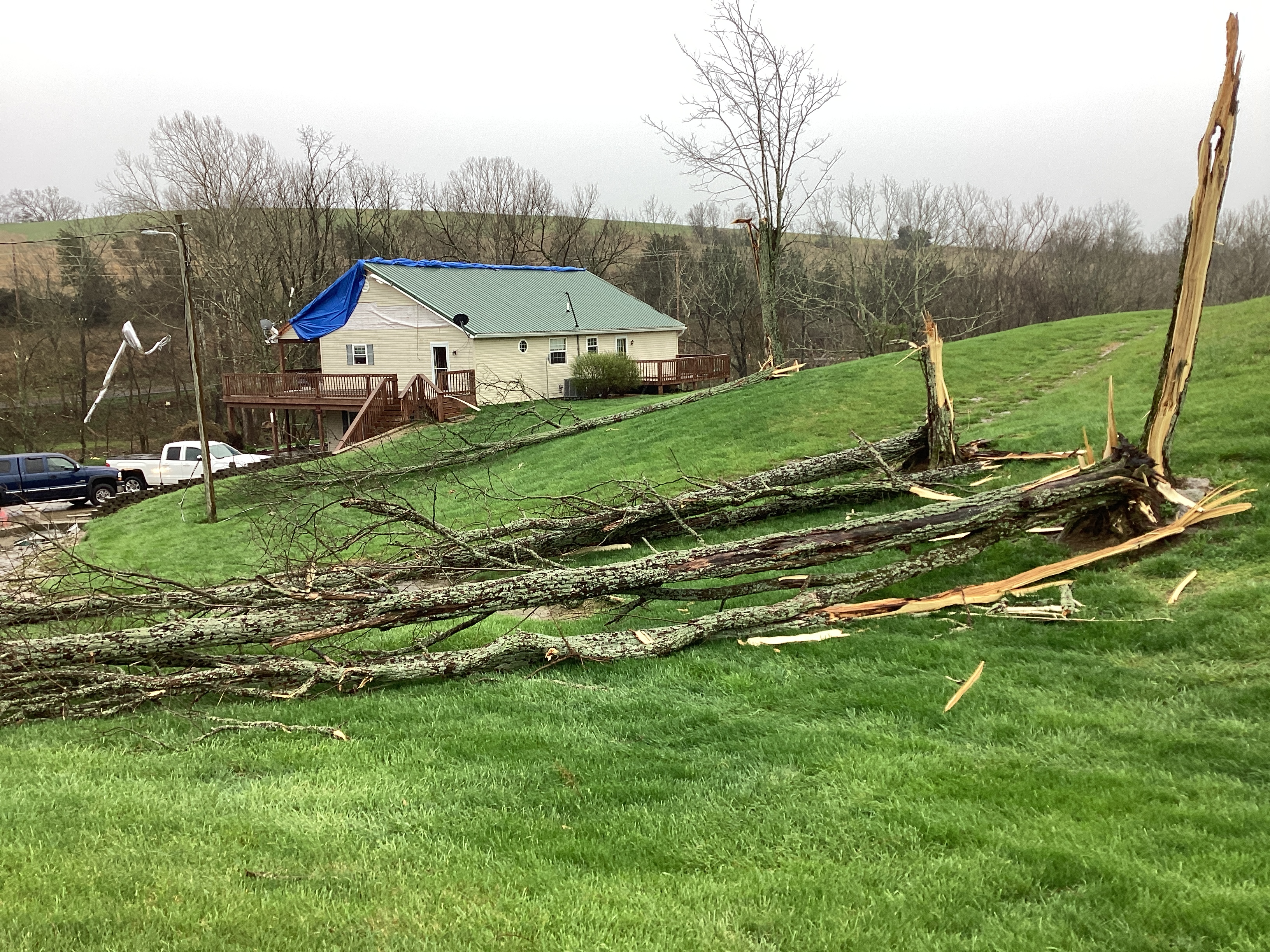
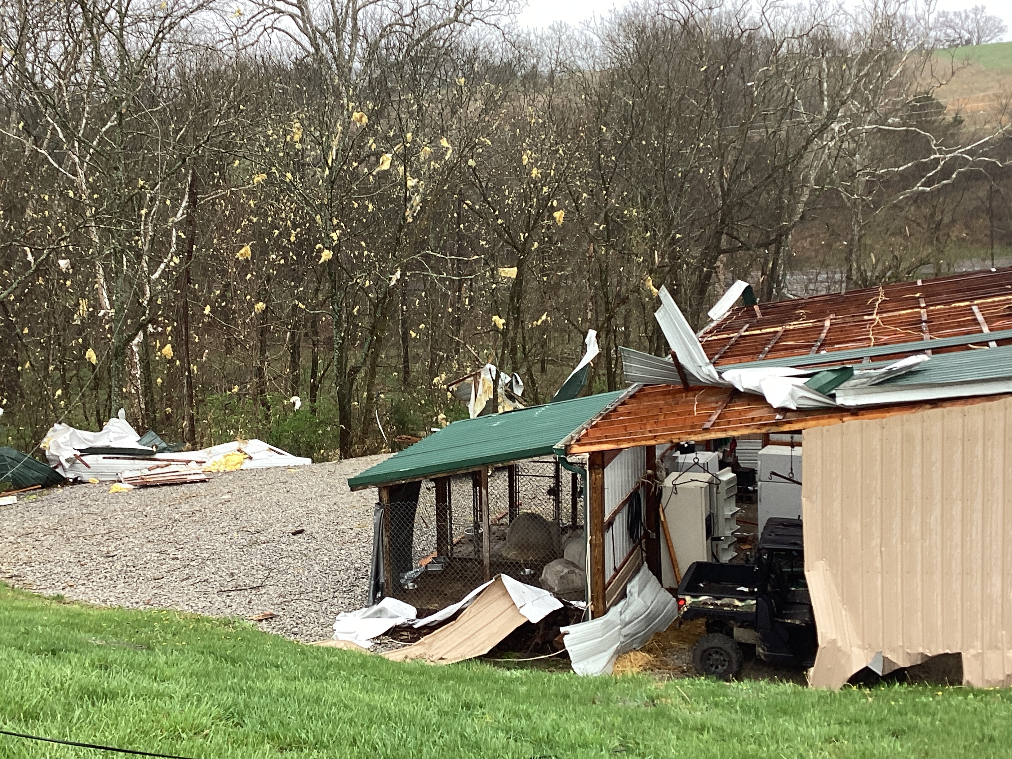
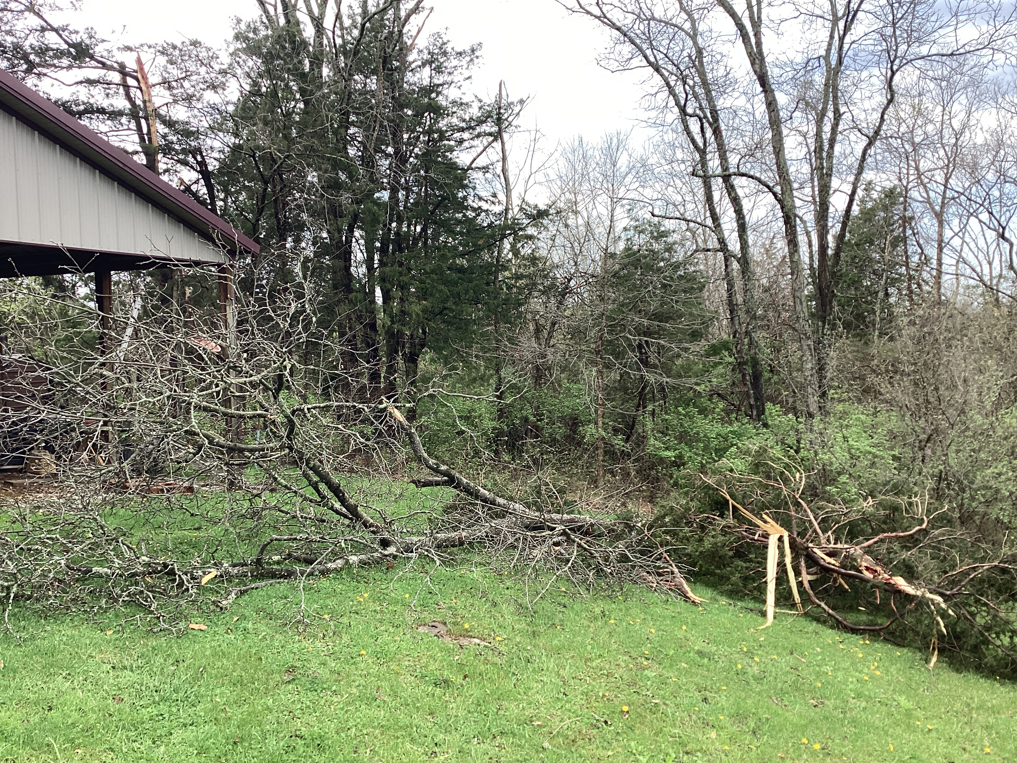
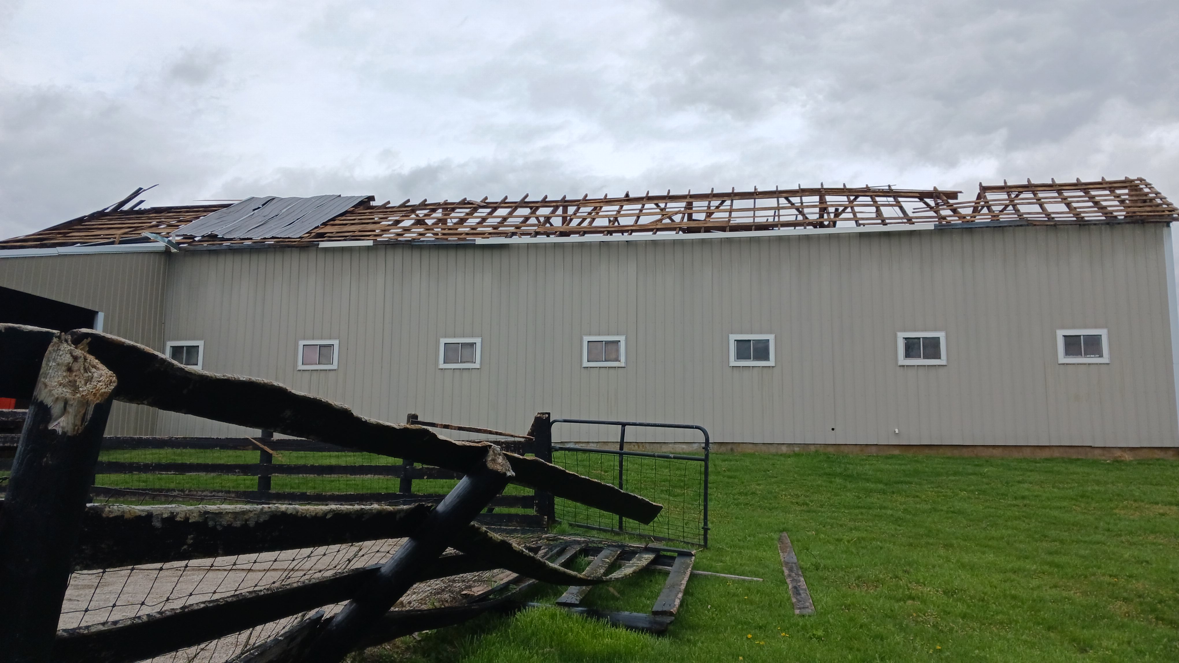
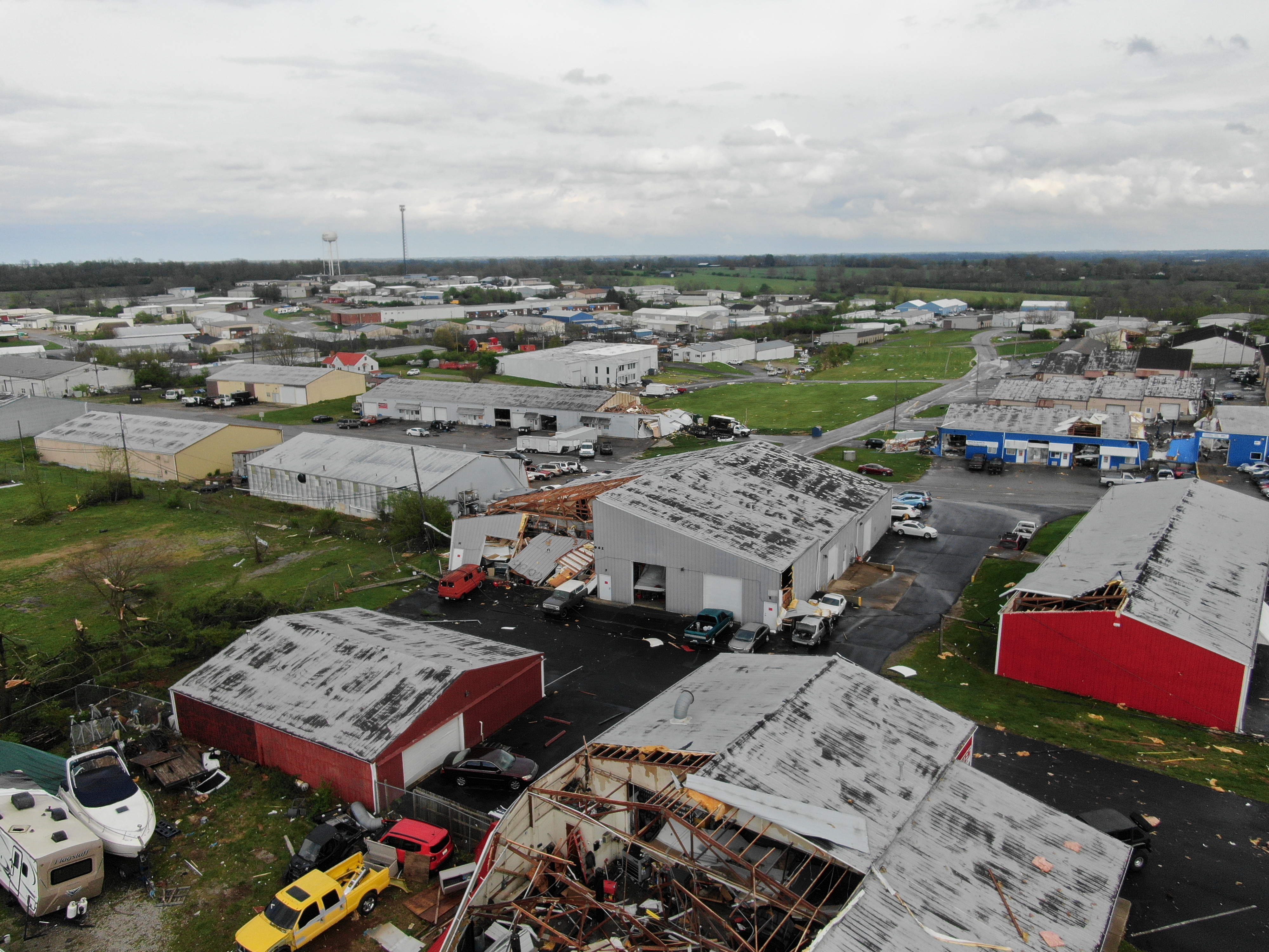
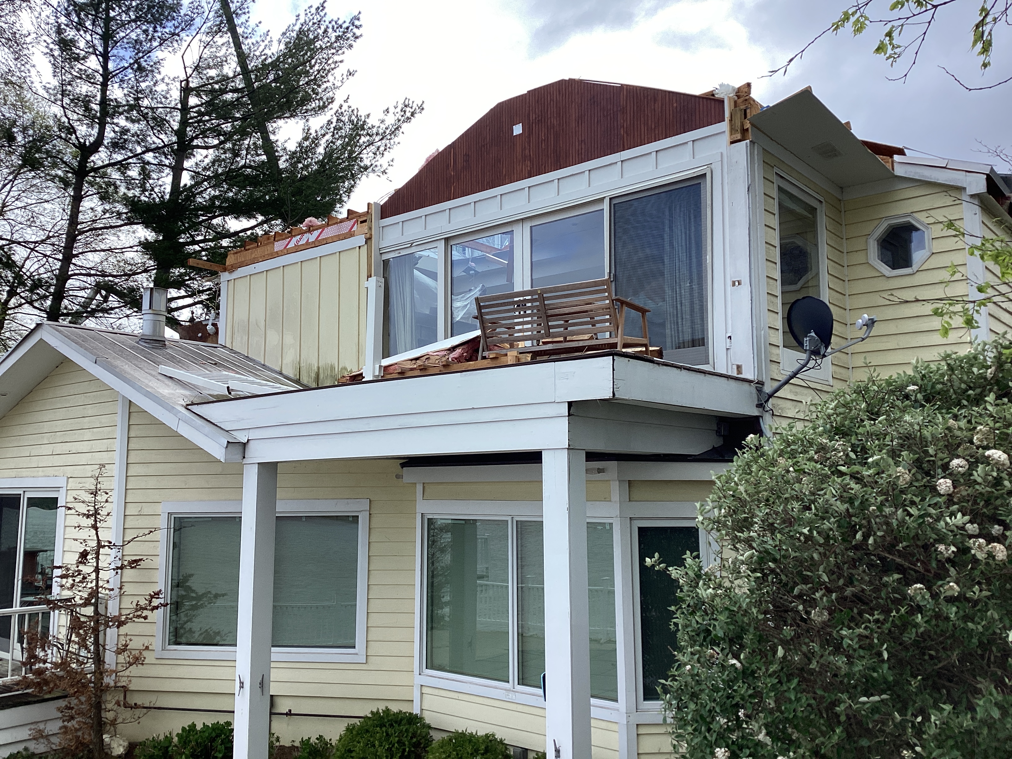
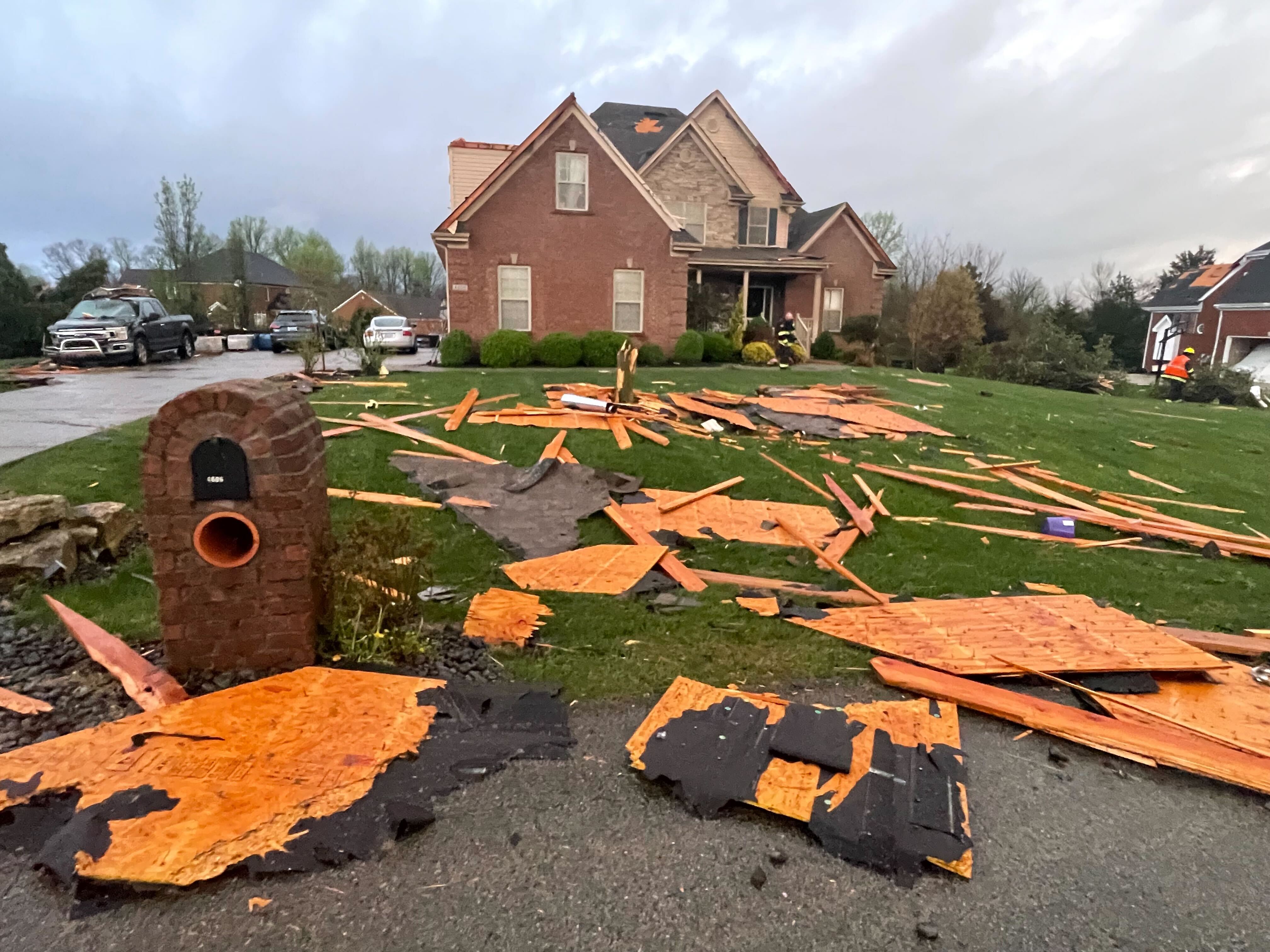
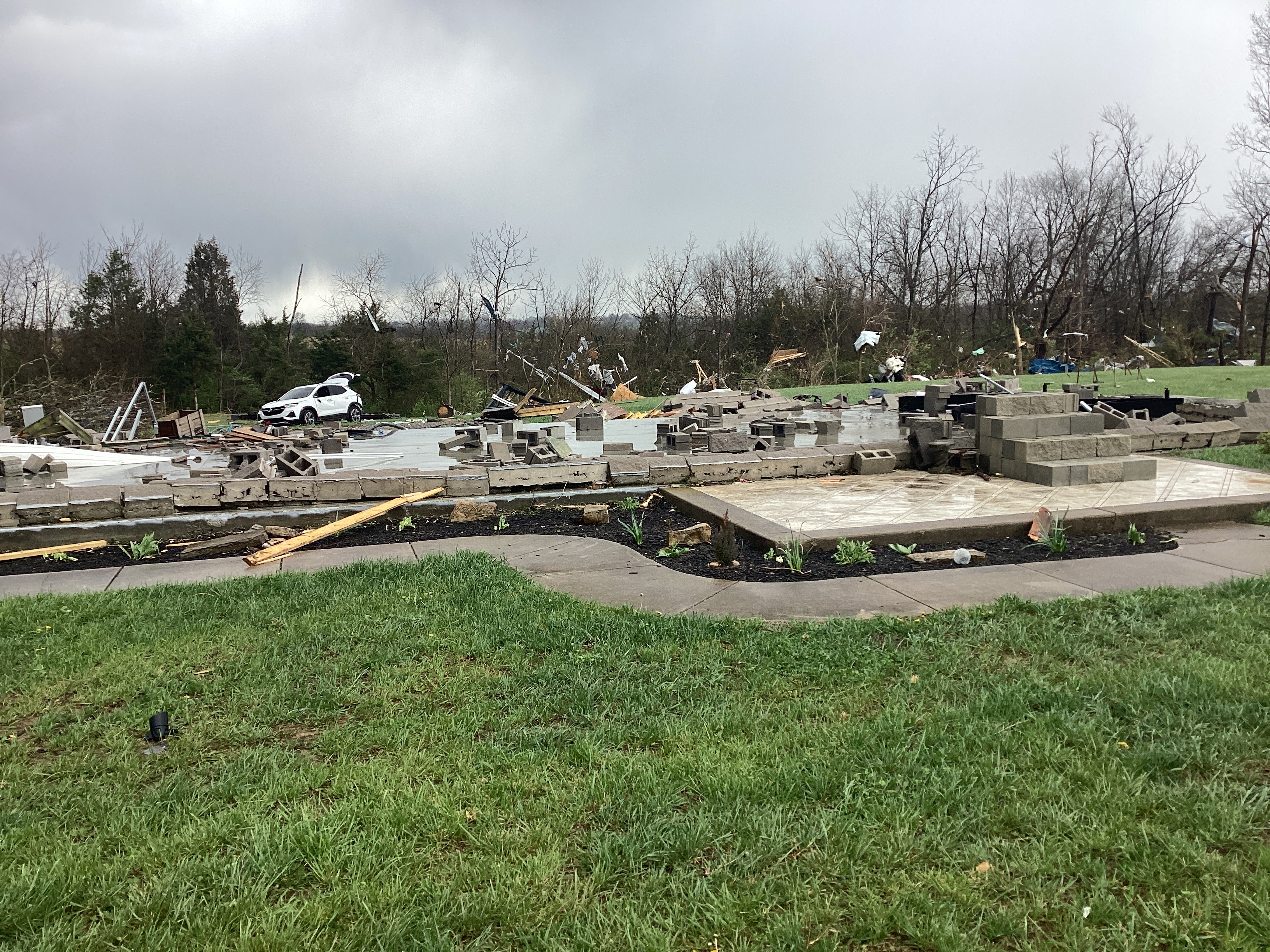
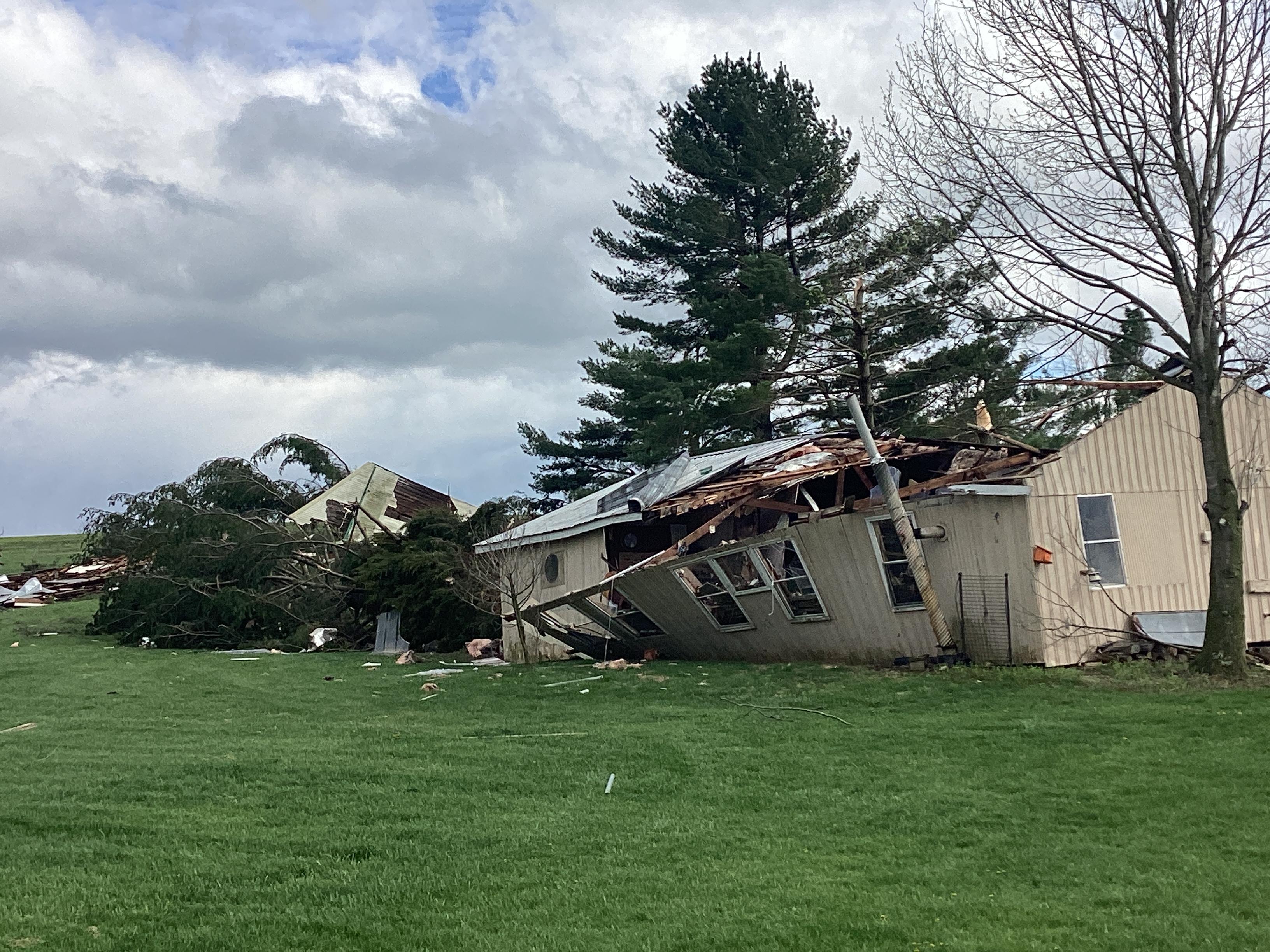
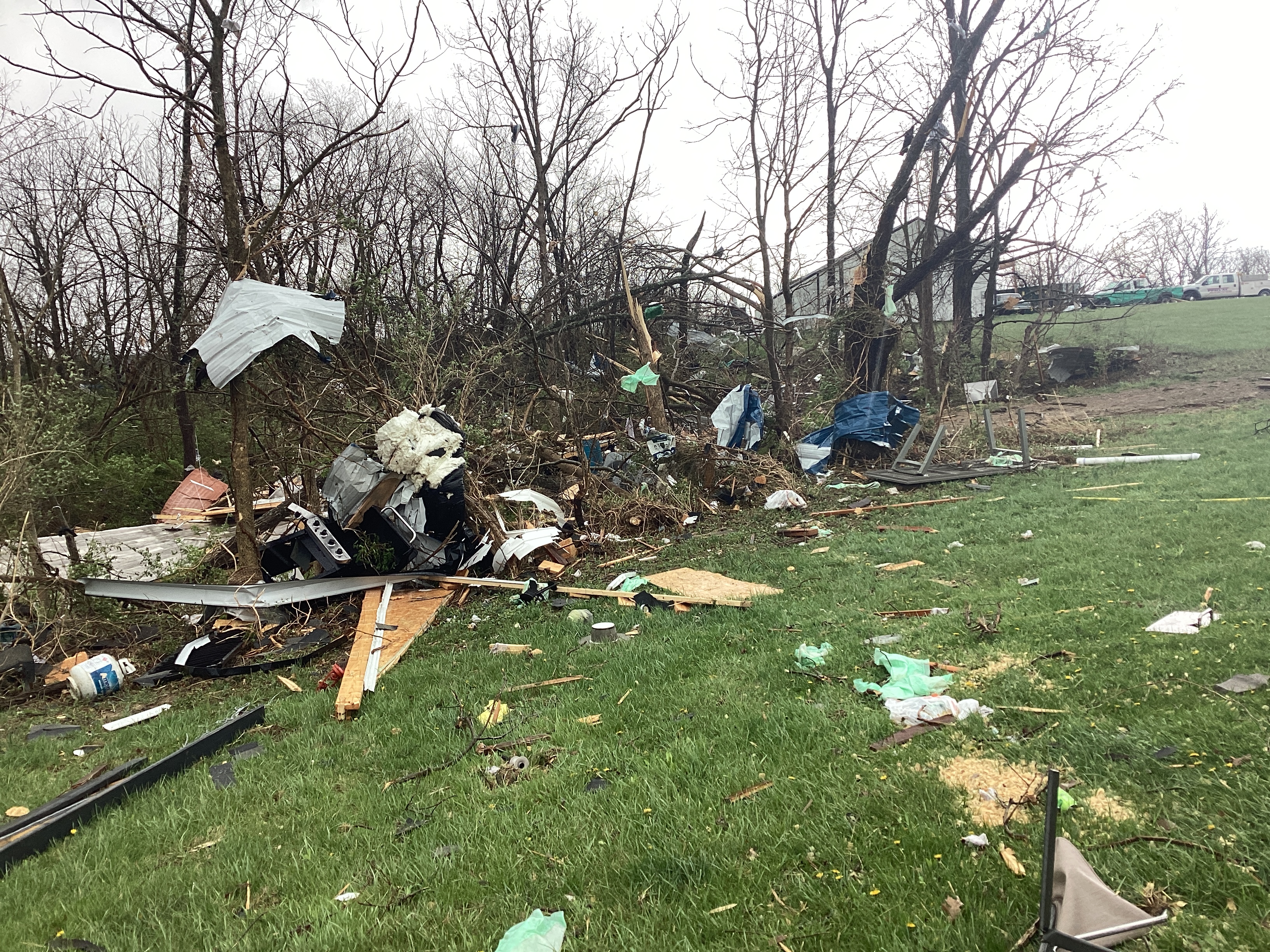
| EF2 damage near Prospect, Kentucky | EF2 damage near Buckner | EF2 damage near Buckner |
Tornadoes
|
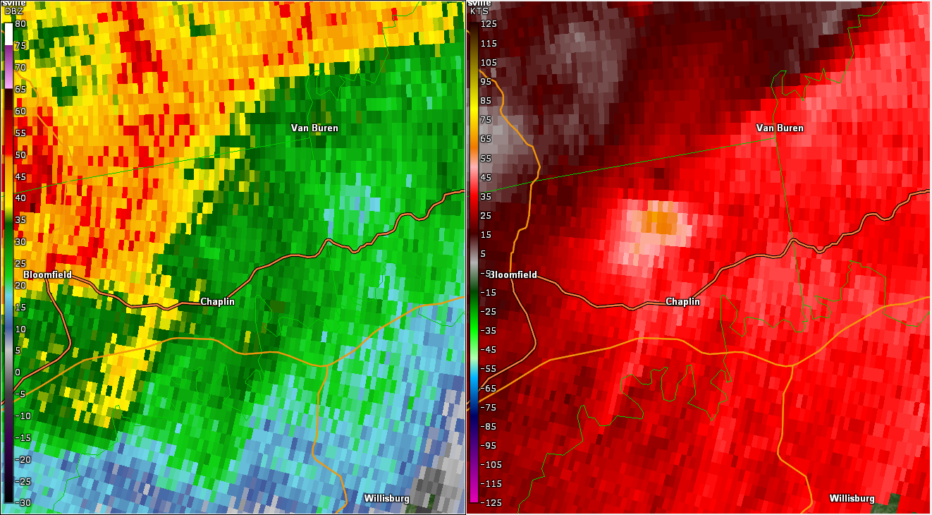
Tornado - Chaplin, KY
|
||||||||||||||||
|
||||||||||||||||
|
Tornado - Glensboro, KY
|
||||||||||||||||
|
||||||||||||||||
|
Tornado - Pinckard, KY
|
||||||||||||||||
|
||||||||||||||||
|
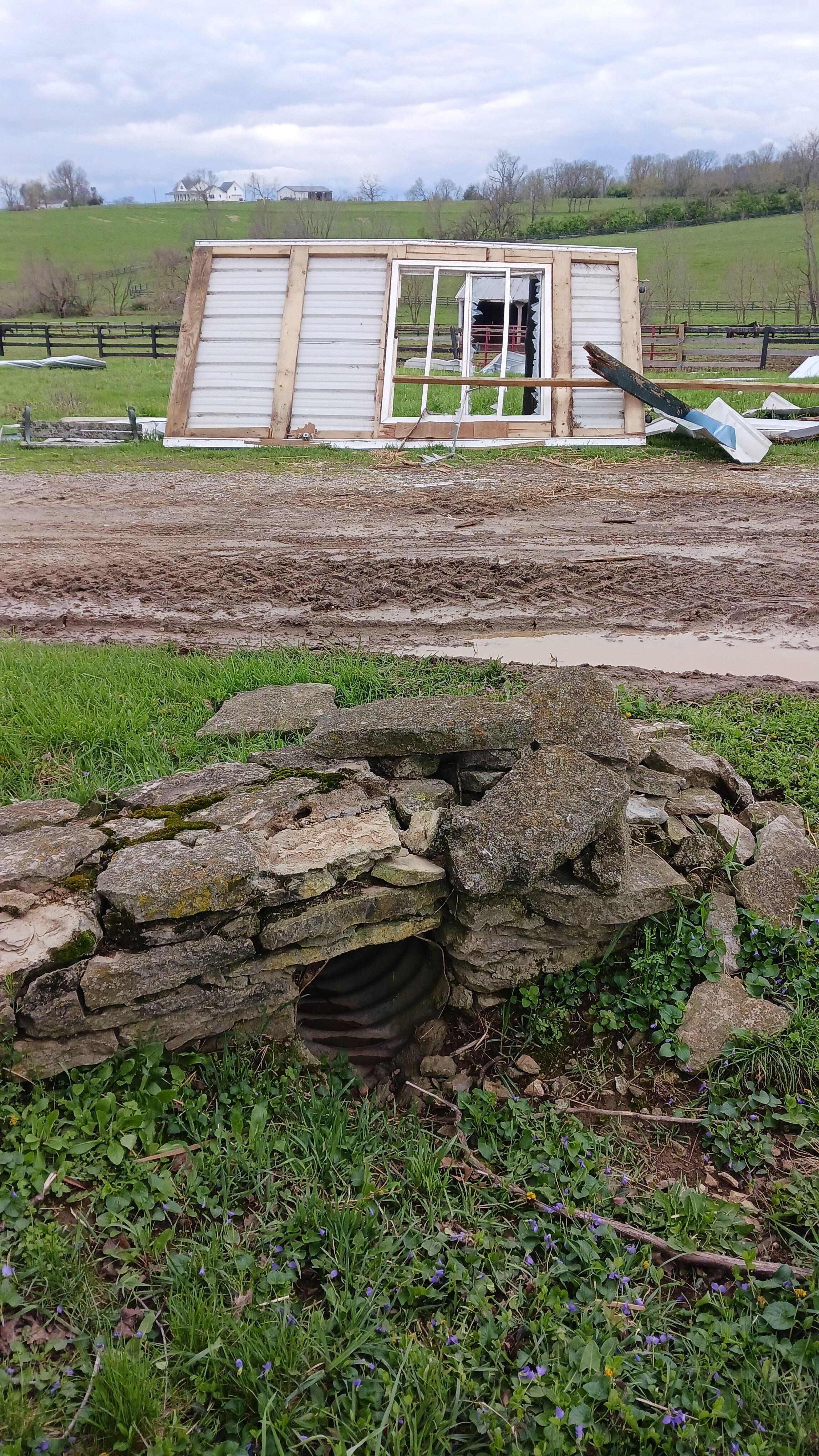
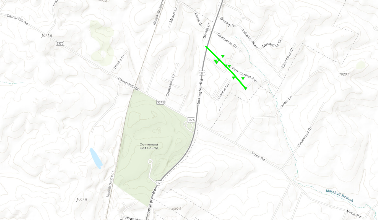
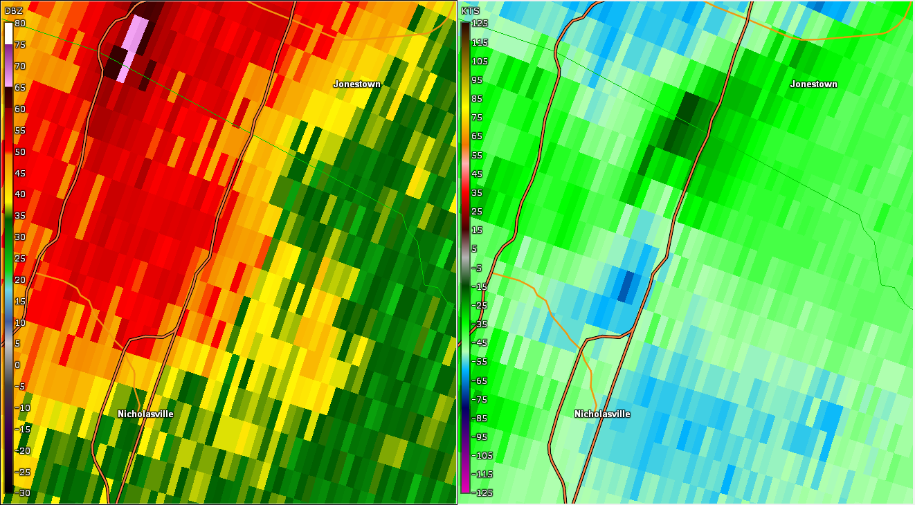
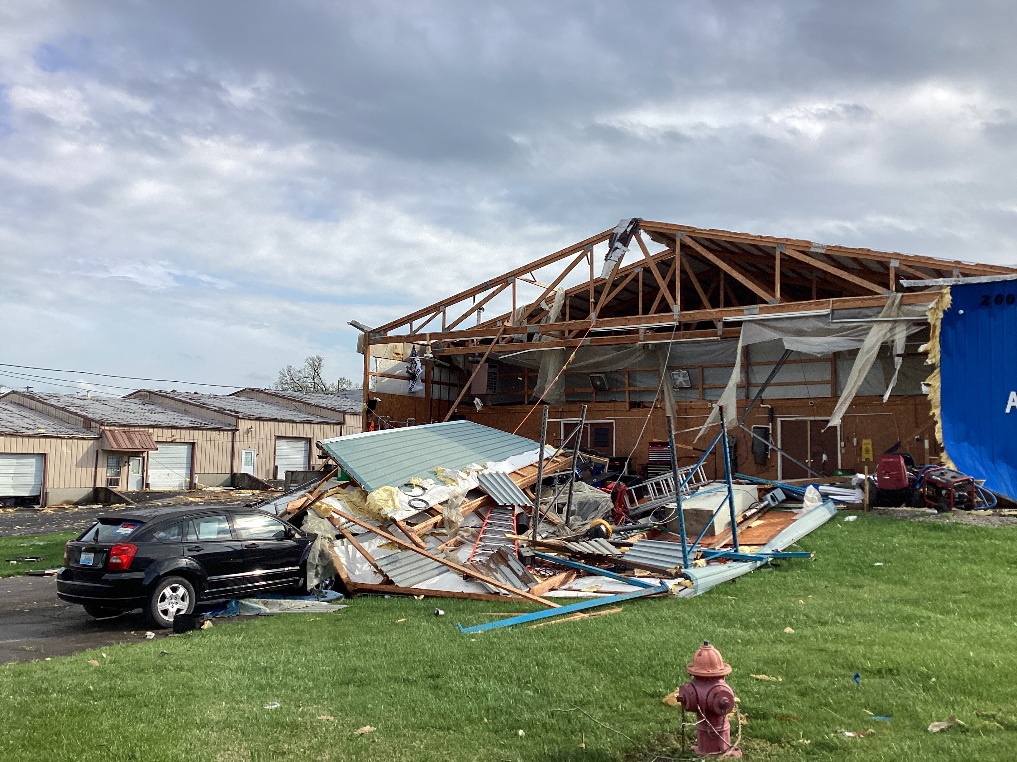
Tornado - Nicholasville, KY
|
||||||||||||||||
|
||||||||||||||||
|
Tornado - Monterey, KY
|
||||||||||||||||
|
||||||||||||||||
|
Tornado - Becknerville, KY
|
||||||||||||||||
|
||||||||||||||||
|
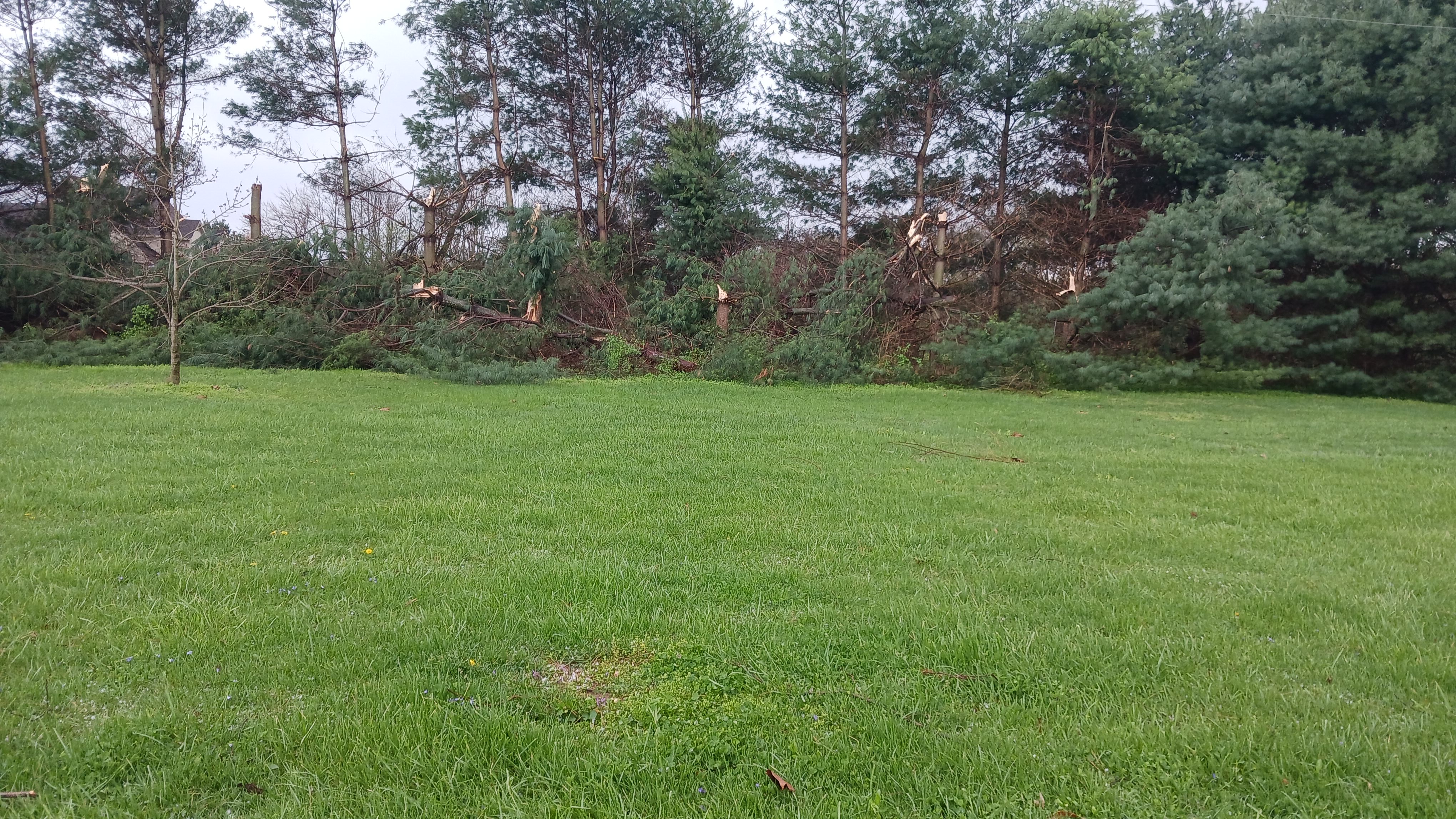
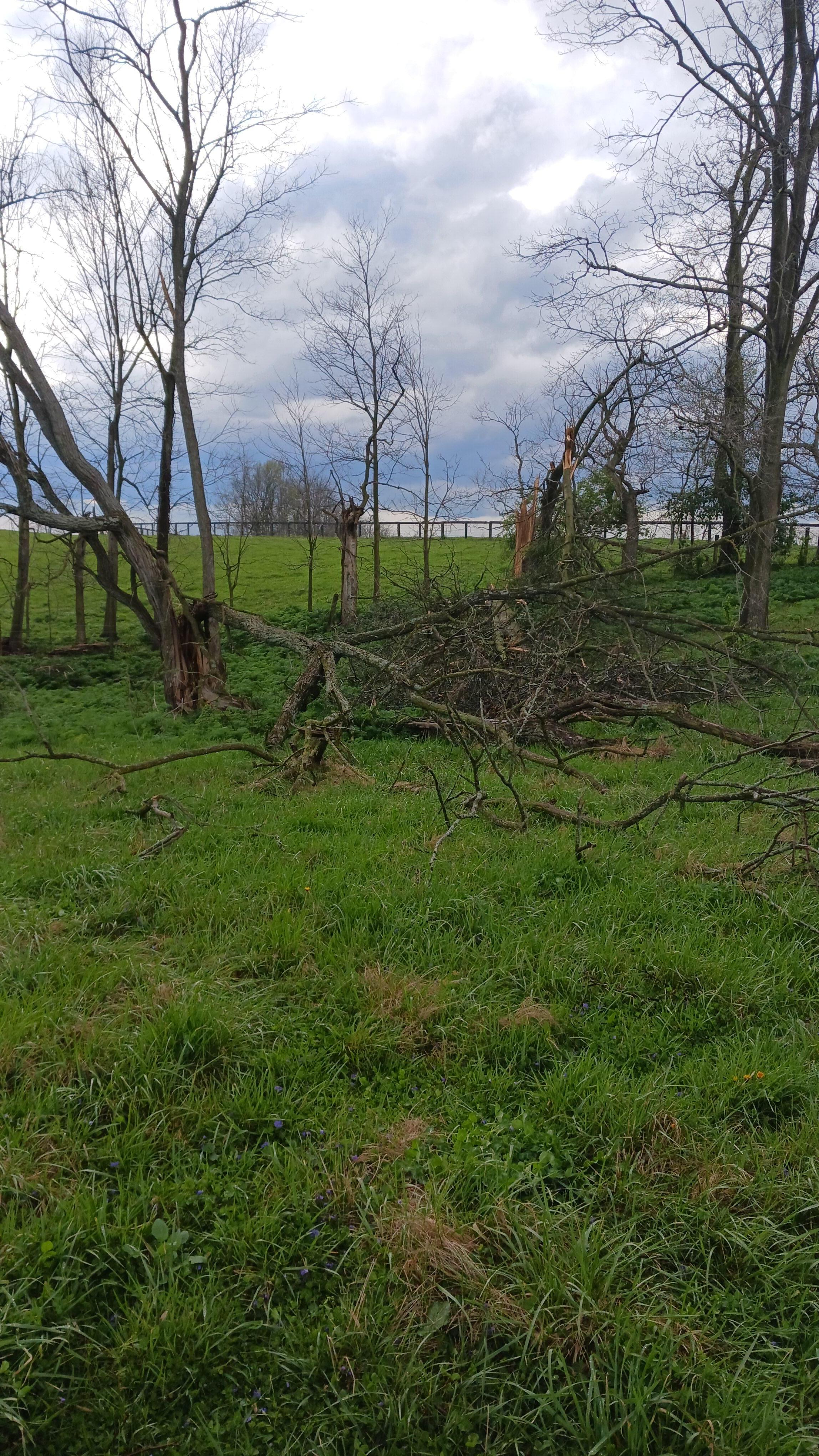
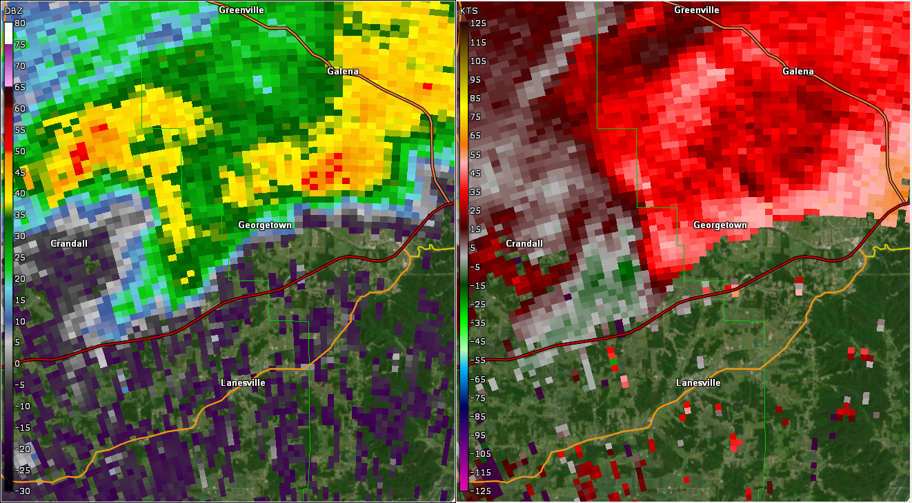
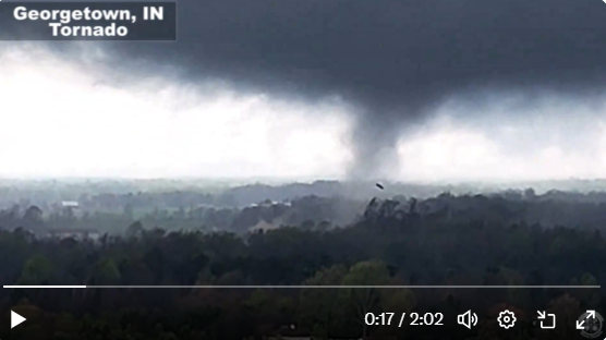
Tornado - Georgetown, IN
|
||||||||||||||||
|
||||||||||||||||
|
Tornado - Utica, IN-Prospect, KY
|
||||||||||||||||
|
||||||||||||||||
|
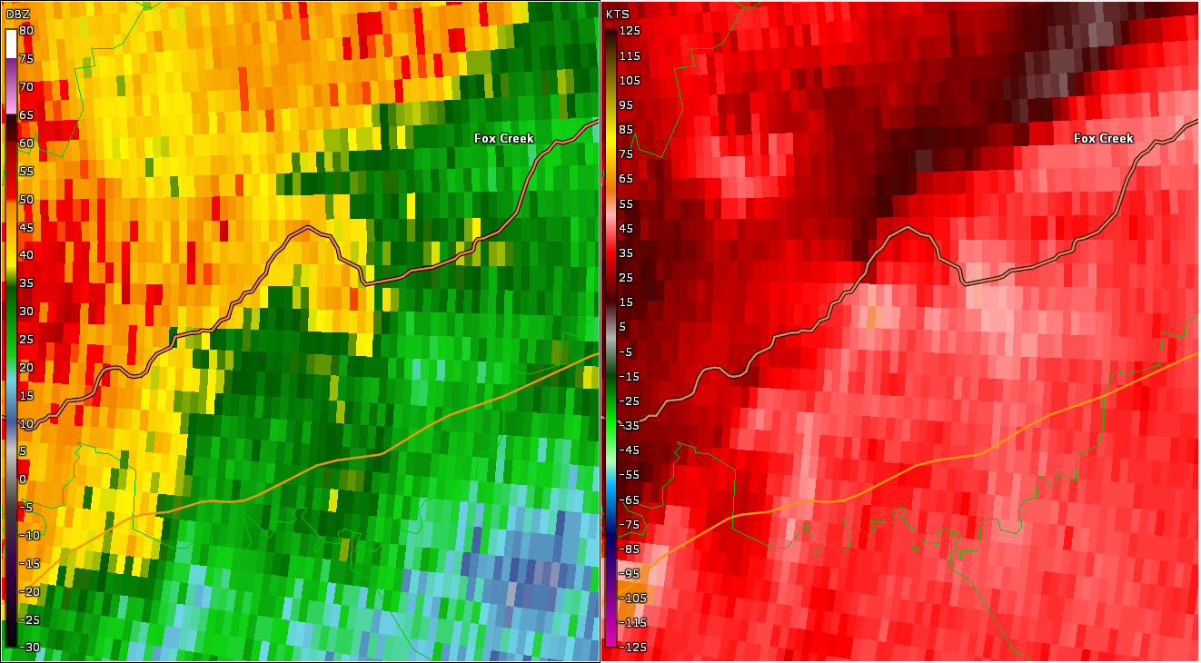
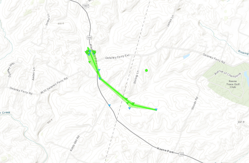
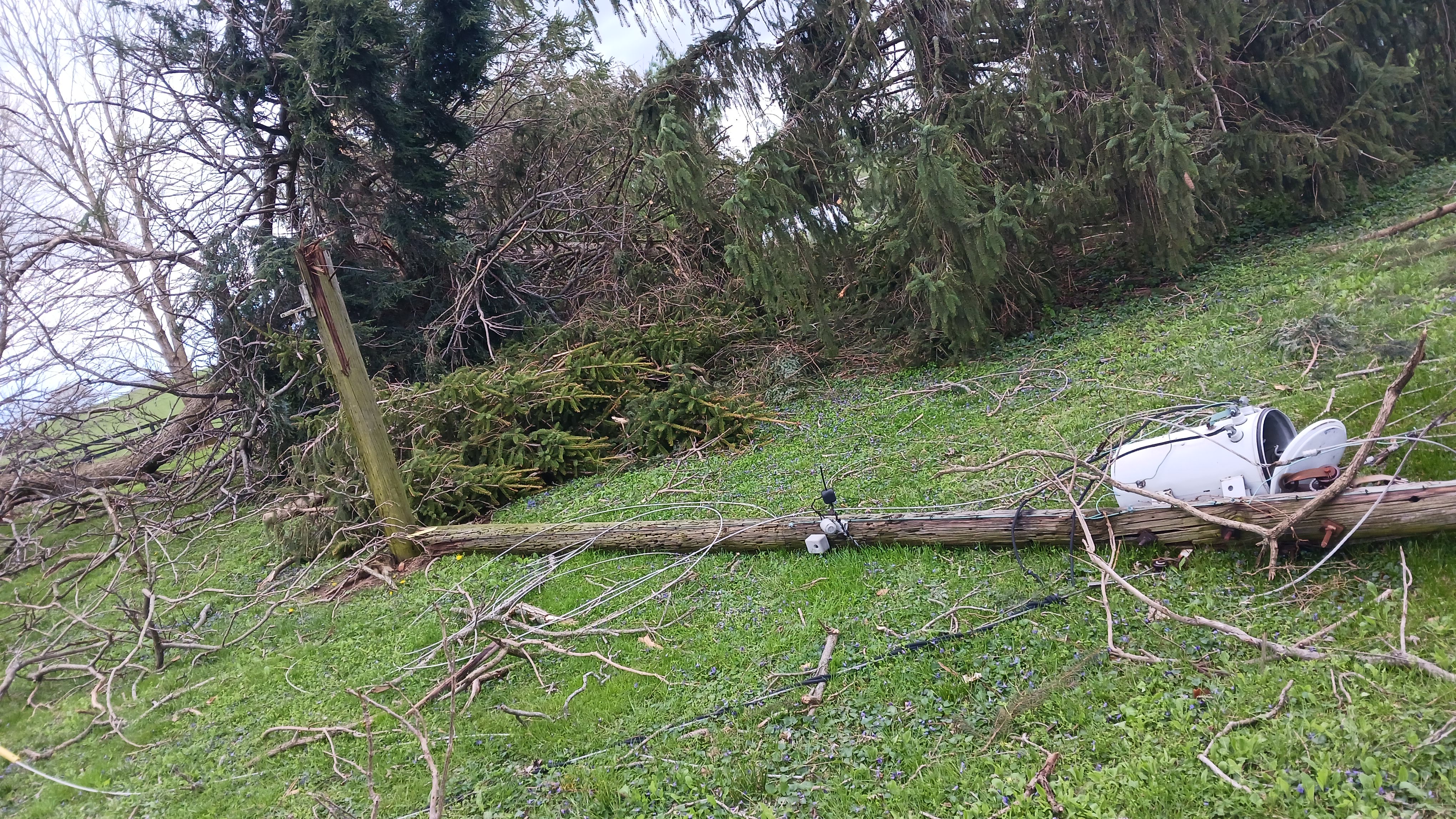
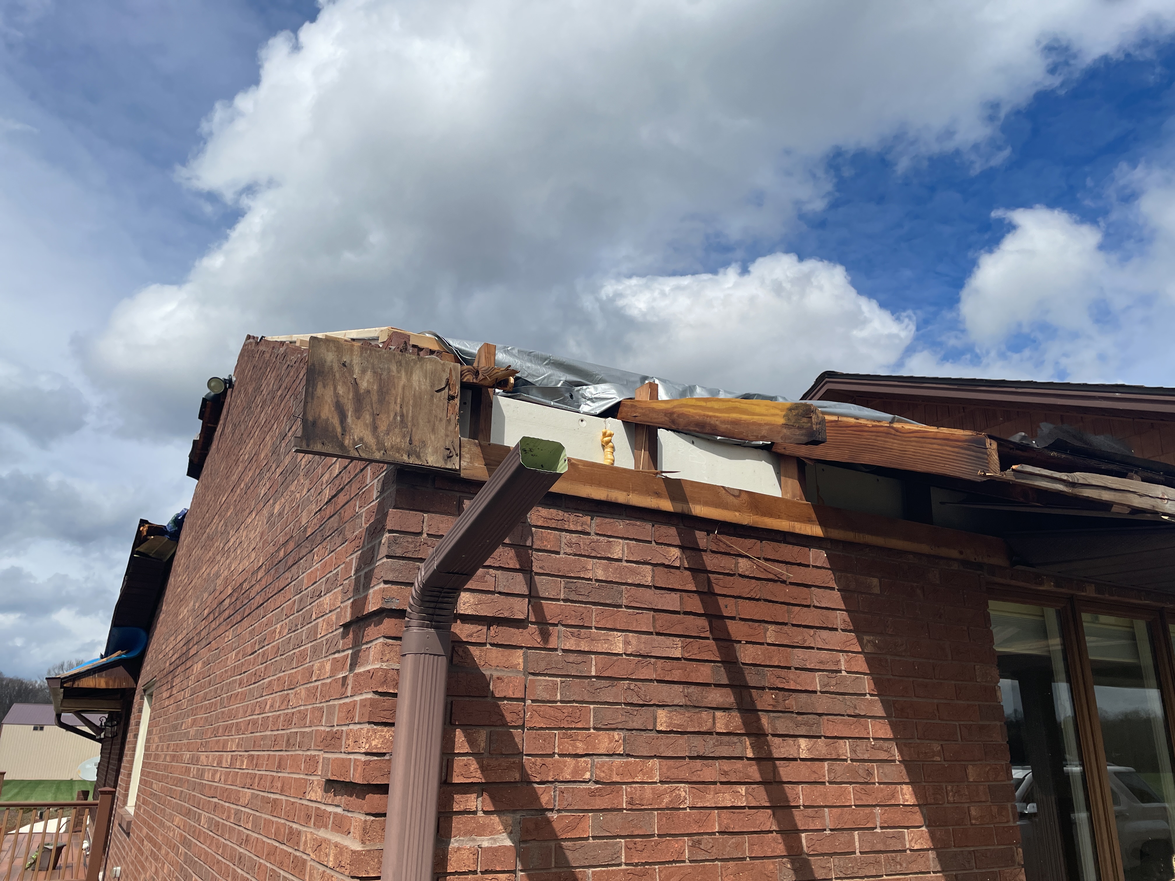
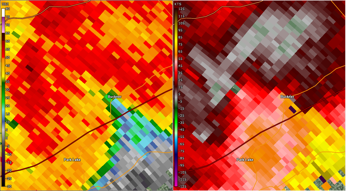
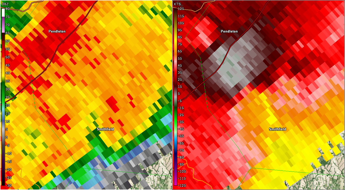
Tornado - Buckner, KY OLDHAM COUNTY
|
||||||||||||||||
|
||||||||||||||||
|
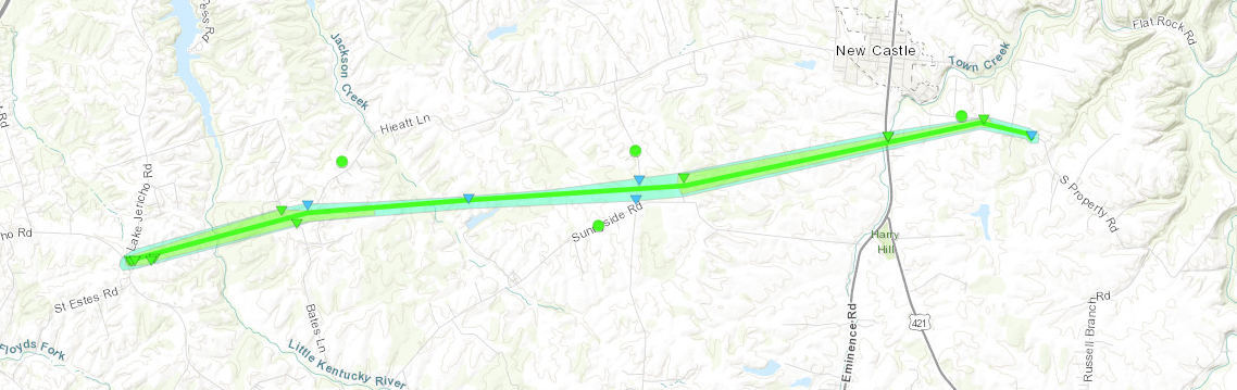
Tornado - Jericho-New Castle, KY
|
||||||||||||||||
|
||||||||||||||||
The Enhanced Fujita (EF) Scale classifies tornadoes into the following categories:
| EF0 Weak 65-85 mph |
EF1 Moderate 86-110 mph |
EF2 Significant 111-135 mph |
EF3 Severe 136-165 mph |
EF4 Extreme 166-200 mph |
EF5 Catastrophic 200+ mph |
 |
|||||
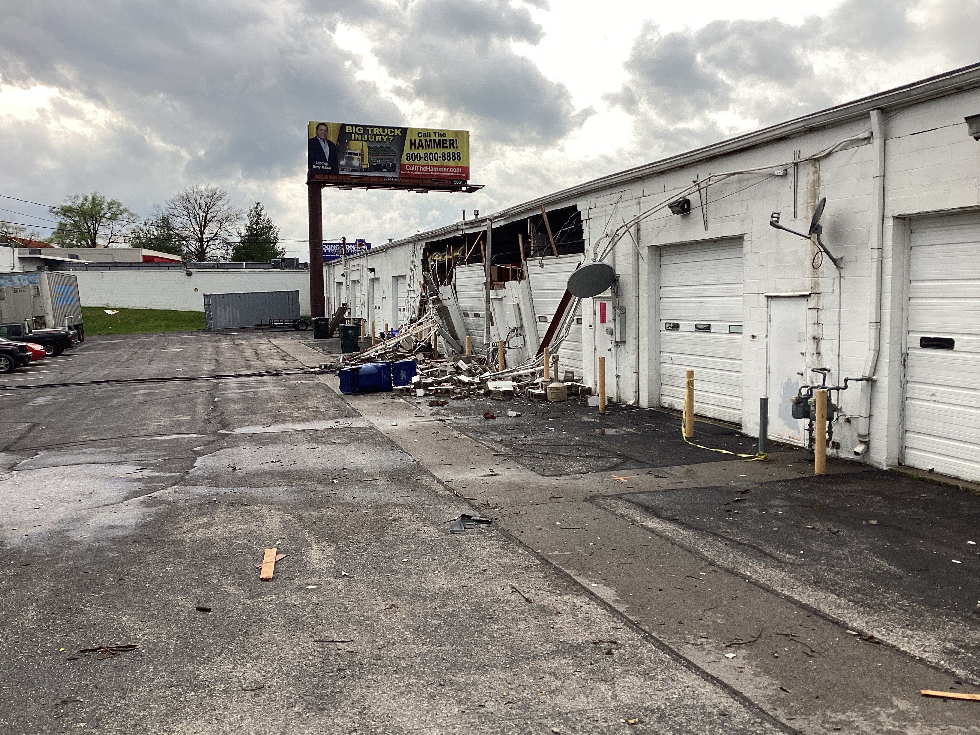
Wind:
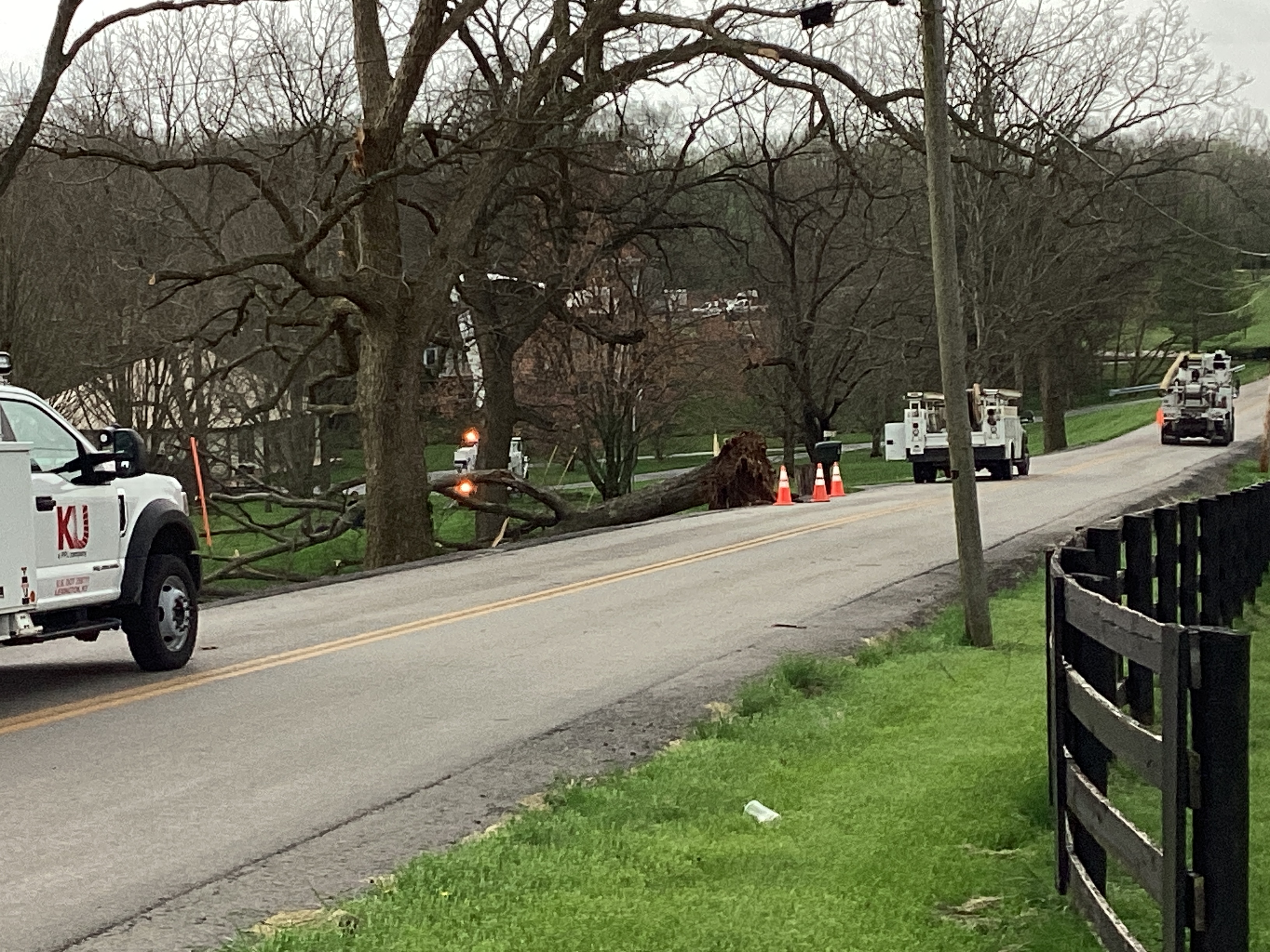
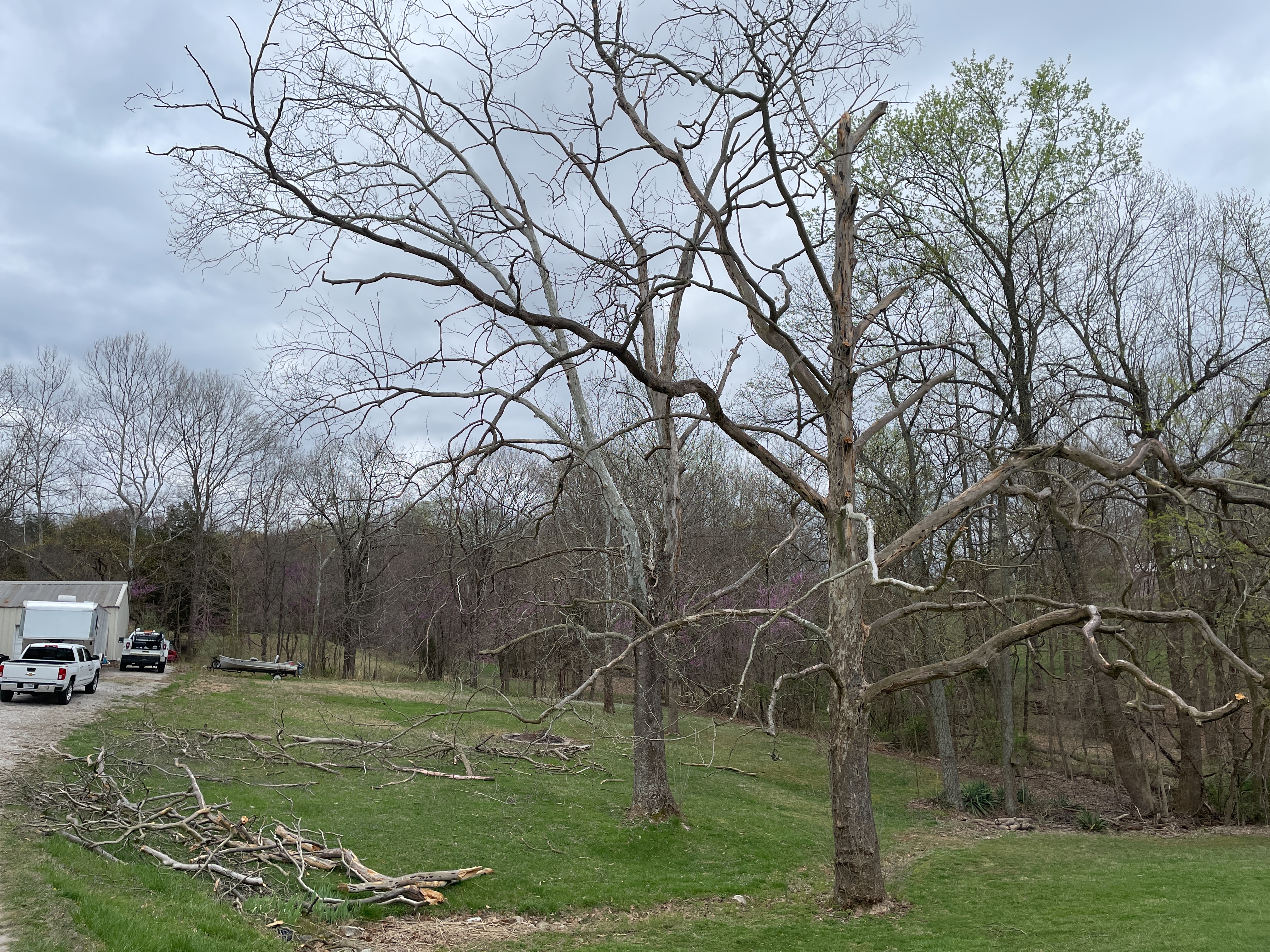
As the strong line of thunderstorms moved through the region, many areas incurred wind gusts up to 80 mph. Here are some pictures of straight line wind damage that resulted from these wind gusts.
 |
 |
 |
 |
| Wind damage near Lexington, KY. | Wind damage near Lexington, KY. | Wind damage near Lexington, KY. | Wind damage near Lexington, KY. |
 |
 |
 |
 |
| Wind damage in Salvisa, KY. | Wind damage in southern Crawford County, IN. | Wind damage in southern Crawford County, IN. | Wind damage in Coxs Creek, KY. |
Video
| Drone video from National Weather Service in Louisville of Beechland Beach and Hunting Creek neighborhoods. |
Storm Reports
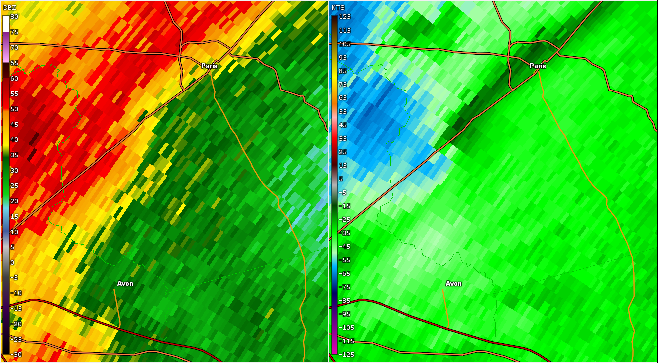
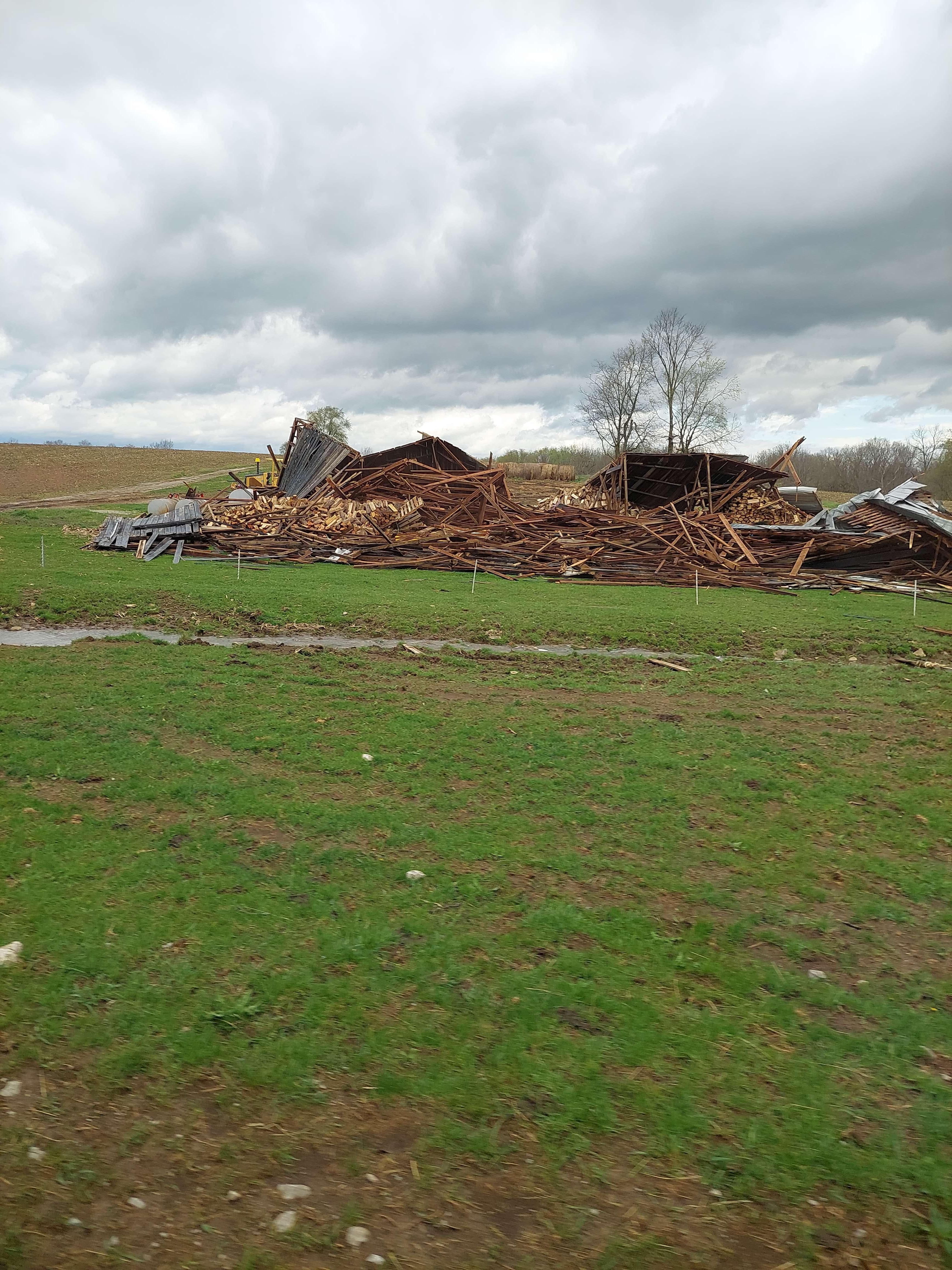
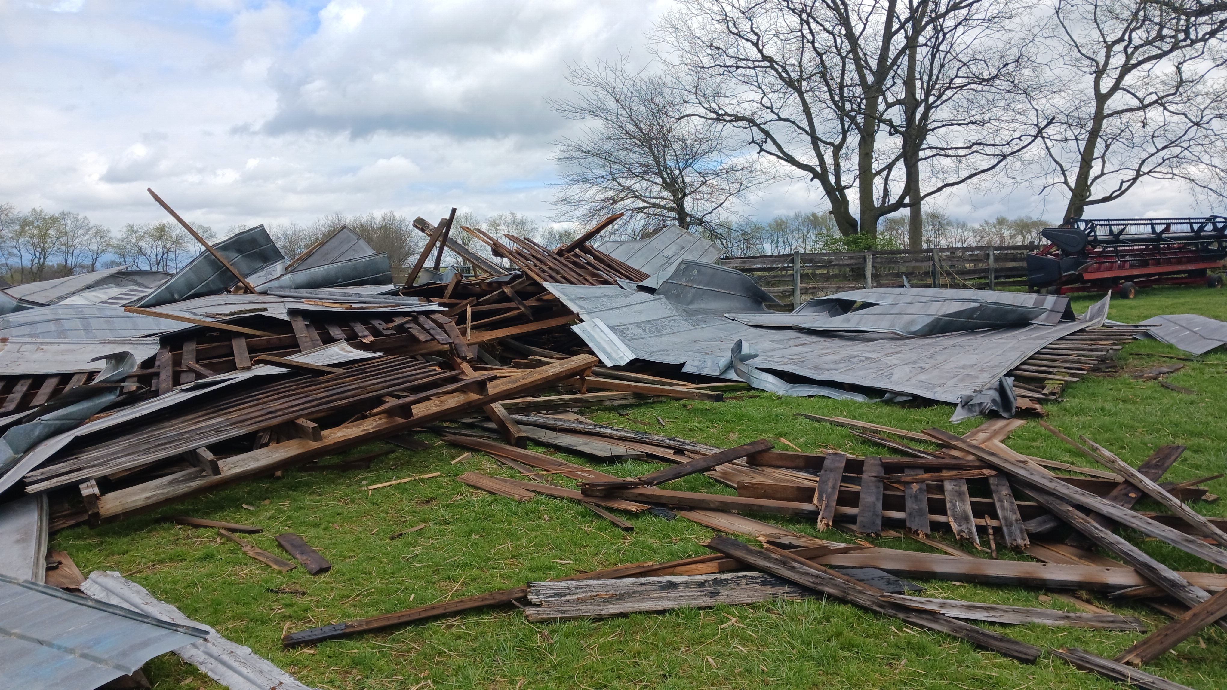
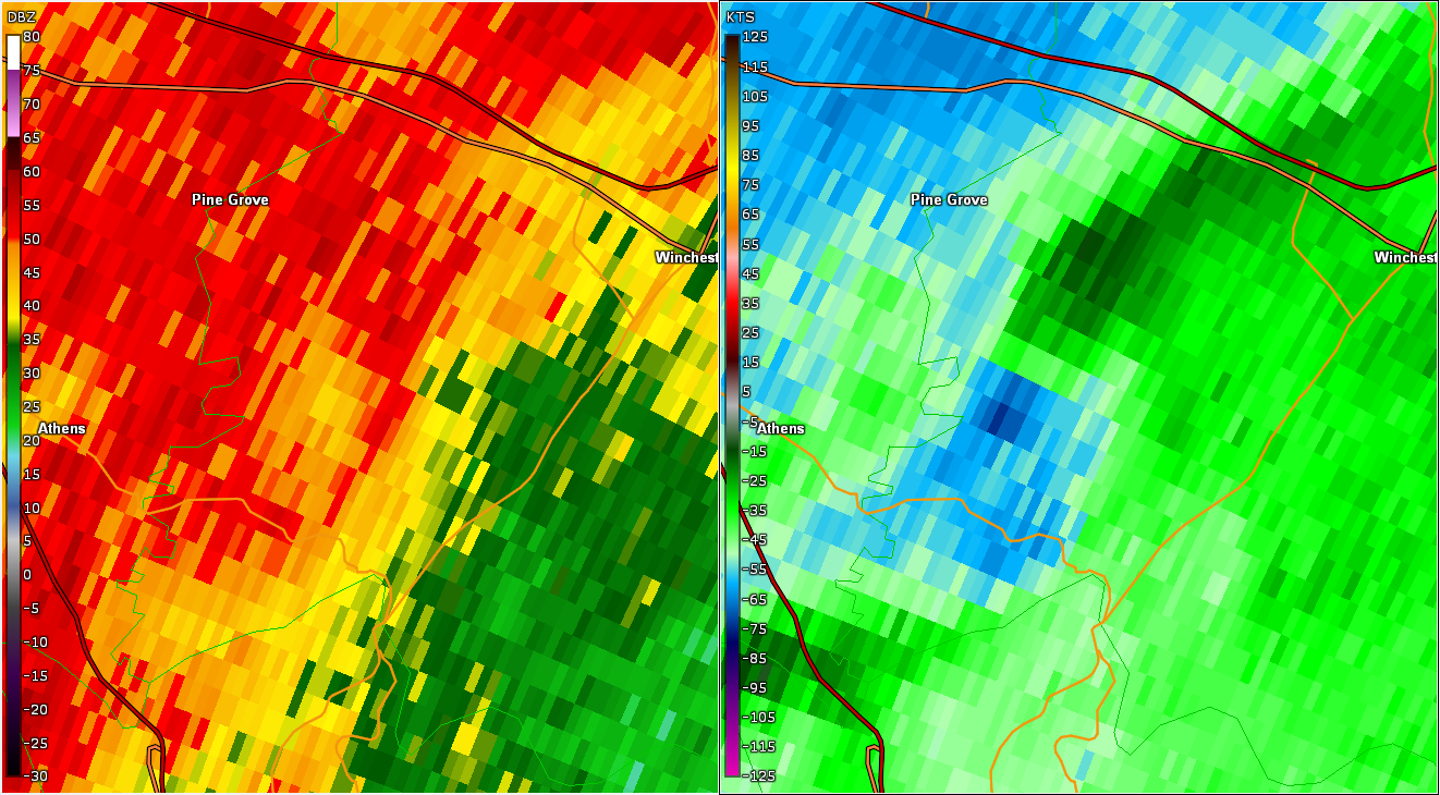
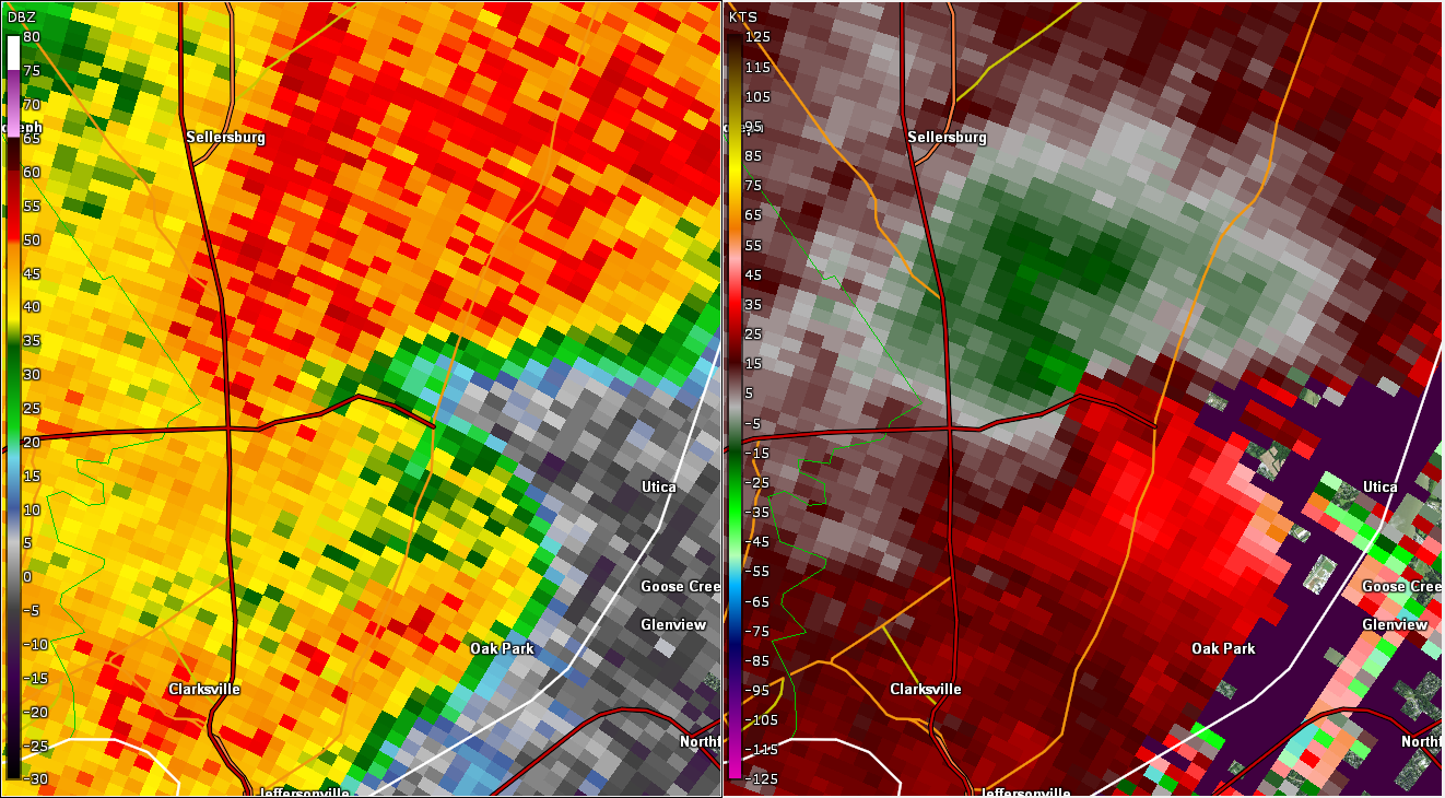
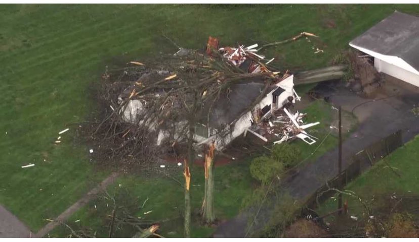
Preliminary Local Storm Report...Summary National Weather Service Louisville KY 129 PM EDT Sun Apr 7 2024 ..TIME... ...EVENT... ...CITY LOCATION... ...LAT.LON... ..DATE... ....MAG.... ..COUNTY LOCATION..ST.. ...SOURCE.... ..REMARKS.. 0512 PM Hail 3 NE Corydon 38.24N 86.10W 04/02/2024 M1.00 Inch Harrison IN Public Delayed Report. 0532 PM Hail 2 N New Albany 38.34N 85.83W 04/02/2024 M1.00 Inch Floyd IN Public Corrects previous hail report from 2 N New Albany. 38.3211/-85.8172. 0545 PM Hail 3 SSE New Amsterdam 38.06N 86.26W 04/02/2024 E0.50 Inch Harrison IN Trained Spotter 0625 PM Hail 2 ENE Middletown 38.26N 85.48W 04/02/2024 M1.00 Inch Jefferson KY NWS Employee 0850 AM Tornado 2 N Chaplin 37.93N 85.22W 04/02/2024 Nelson KY NWS Storm Survey Corrects previous tornado report from 2 N Chaplin. The National Weather Service found a tornado consistent with EF1 95 mph peak winds. The length was 5.01 miles long with a width of 125 yards. The total duration was 6 minutes. The tornado touched down between Maude Cooksey Lane and Hagan Lane, just northwest of Chaplin, in northeast Nelson County. Drone photography and a resident showed extensive tree damage in the middle of a farmers field near several farmers ponds. Winds speeds were around 80 mph with a width of 75 yards. The tornado increased in speed to EF1 90 mph all along Hahn Ridge Road. 10 Barns had extensive roof damage, with debris spread to the east through southerly directions and parts of the barn were thrown up to a half a mile downwind. The width increased to 125 yards. There was extensive tree damage along with significant structural damage to the Barndominion at KY 62 and Hahn Ridge RD on the north side of 62. This large barn garage structure, lost its entire side garage and was thrown several hundred yards to the east southeast. There were significant 2 by 4 and 2 by 8 boards impairments up to 300 yards downwind. Winds increased to EF1 95 mph with a width of 125 yards. There were trees uprooted and topped along Prather Ridge Road as the tornado continued to move to the east southeast. The tornado was consistently around 85 mph, EF0, with a width of 125 yards. There was uplift of two outbuildings along Love Ridge Road, along with uprooted and topped trees. Winds speeds were around 85 mph with a width of 100 yards. The tornado was weakening as it crossed Kentucky 555 and the Chaplain River. There were a few top trees and wind speeds had decreased to 75 mph with a width of 60 yards. 0856 AM Tornado 3 SSE Glensboro 37.96N 85.05W 04/02/2024 Anderson KY NWS Storm Survey NWS Survey found damage consistent with EF 1 90 mph peak winds. The tornado lasted 3 minutes, was 2.10 miles long, and was 150 yards wide. The tornado touched down in far southwest Anderson county just off Mays Rd (just west of KY 53) snapping and twisting some trees. Winds speeds were around 75 mph with a width of 50 yards. The tornado increased in speed to EF1 95 mph along Willisburg Rd (KY 53). A well built home had extensive roof damage, 2 barns lost large sections of their roofs. Insulation and metal sheeting from the barns were thrown up to 300 yards to the east and southerly direction. The resident was in his basement, and heard the roar and had his ear pop from the low pressure. The width increased to 100 yards. The tornado continued moving to the east southeast damaging more trees on Baxter Ridge Road. One house had shingle, soffit and gutter damage. Winds speeds were EF0, 85 mph with a width of 150 yards. Drone photography was used to find the ending point in a grove of trees, halfway between Baxter Ridge Road and Puncheon Creek Rd. Drone photography found a few topped and uprooted trees. Winds speeds were around EF0 75 mph with a width of 50 yards. 0856 AM Tornado 4 E Chaplin 37.89N 85.15W 04/02/2024 Washington KY NWS Storm Survey Trees down here as the end point to the tornado in Nelson County. EF1 95 mph. 0911 AM Tornado 4 NW Keene 37.98N 84.68W 04/02/2024 Woodford KY NWS Storm Survey Damage to many trees and structures. Two barns demolished. EF1. 0919 AM Tornado 4 NNE Nicholasville 37.94N 84.55W 04/02/2024 Jessamine KY NWS Storm Survey The tornado touched down on the northeast side of Nicholasville off of US 27 just south of the Sam’s Club, but north of the Providence school. The tornado touched down just west of US 27 by storage shed roadside company. Two of the storage sheds were picked up and thrown onto the highway. Winds speeds were 90 mph (EF1), with a damage width of 75 yards. The tornado crossed US 27 and increased in speed and size, going into the Park Central Industrial Park doing the most extensive damage of the short tornado track. Many buildings and warehouses had significant portions of their roof torn apart, doors blown out, and wall panels pulled away from their buildings. Buildings that did not lose any part of the roof had numerous shingles removed from the top of the roofs. There were impalements of boards and drywall into surrounding buildings and the ground. Winds speeds were 110 mph, EF1, with a width of 150 yards. A car lot had 3 vehicles picked up and flipped over and a very heavy travel trailer was moved 20 yards and shifted 30 degrees to the east northeast. Debris from the industrial park was thrown into a heavily wooded area and thrown in directions from the east northeast all the way to the southeast. 0920 AM Tornado 5 SSW Paris 38.15N 84.30W 04/02/2024 Bourbon KY NWS Storm Survey NWS storm survey found damage consistent with EF1 tornado damage 105 mph peak winds. The tornado lasted 15 minutes, was 13.44 miles long and 100 yards wide. This fairly long tornado, for a squall line, started off as a trio of funnels that merged into one tornado at touchdown, per eyewitness accounts on a farm off Bethlehem Rd. Multiple structures on the farm had damage. The tornado continued east southeast thru rural parts of southern Bourbon county with few roads to gain good access to damage, but there were some trees down in Sidville and south of Escondida. The most extensive and widespread damage occurred at Hidden Rose Farm. A lot of people had gathered to fix the damage, but evidence of the tornado still was clear. An open arena structure almost totally collapsed, with one wall standing. Another downstream stable had roof damage including a 4x6 wood beam that was lodged in the metal roof, though that roof was fixed by the time of the survey. Multiple trailers were flipped as well. 2 horses were taken to the animal hospital and 4 others had lacerations. The tornado continued southeast to a large property off the 6700 block of Paris Rd, in far north Clark County. The home had several older healthy trees near the home downed as well as a barn demolished. A very old stone cabin downwind of the home escaped damage, likely because of the upstream trees and the home structure. Some additional tree damage occurred along Pretty Run Rd. The tornado last caused damage to a large new barn in Wades Mill area before lifting. 0928 AM Tornado 5 SW North Middletown 38.09N 84.18W 04/02/2024 Clark KY NWS Storm Survey NWS Storm survey found a tornado crossed into Clark County, KY from Bourbon County, KY. Tree trunks were snapped, which was found to be consistent with 95 mph EF1 tornado damage. 0930 AM Tornado 7 WSW Winchester 37.98N 84.31W 04/02/2024 Clark KY NWS Storm Survey The NWS conducted a survey and found damage consistent with an EF1 tornado with max winds of 104 mph. The tornado lasted 3 minutes, was 1.94 miles long and 150 yards wide. Tornado damage appeared to have started to a barn and some trees across a field from each other west of Combs Ferry Rd. The tornado continued southeast towards a residence. Trees were downed here with some outbuildings roofs damaged. Residents of one home said a set of 2nd story windows popped out and fell to the ground. Another nearby resident said all the interior doors of their home opened up as the tornado passed by. A security camera video showed a white intense area of rainfall moving across the property in an area where a row of trees ended up getting snapped. The tornado continued east southeastward toward a home near the intersection of Jones Nursery Rd and Combs Ferry Rd. The resident was in a nearby attached garage when it went through. He witnessed the rains going in one direction before the tornado hit and then switch quickly to a different direction behind it. One section of the main homes roof was completely taken off and thrown east southeast. The wind hit the west facing garage doors flush, causing both doors to buckle but not collapse. The brick work in between the doors was buckled as well. No further damage was noted southeast of this property, so the tornado appeared to have lifted by this point. There were several trees downed on the south side of the tornado, likely with strong inflow winds. Jones Nursery Rd had trees down all along the road, but most of the damage had been cleaned up before the survey occurred. 0935 AM Tornado 5 S North Middletown 38.07N 84.09W 04/02/2024 Clark KY NWS Storm Survey NWS storm survey found the end of tornado damage from a 13.44 mile long tornado in Bourbon and Clark counties in Kentucky. A tree was uprooted with minor damage to a nearby home. A 2x4 wood plank was thrown into an outbuilding metal roof. Winds were found to be consistent with EF0 85 mph peak winds at this location. 0109 PM Tornado 3 ESE Crandall 38.27N 86.02W 04/02/2024 Harrison IN NWS Storm Survey NWS storm survey determined an EF1 tornado with a maximum wind speed of 95 mph. The tornado impacted portions of Georgetown, IN in Floyd and Harrison Counties on April 2, 2024. The tornado was on the ground for 3.17 miles and 7 minutes. The maximum width was 30 yards. This LSR is the starting point of the tornado. Please see the associated PNS for more details about this tornado. 0531 PM Tornado 1 W Watson 38.35N 85.72W 04/02/2024 Clark IN NWS Storm Survey *** 22 INJ *** NWS storm survey determined an EF2 tornado with a maximum wind speed of 120 mph. The tornado impacted portions of northern Utica, IN and Prospect, KY on April 2, 2024. The tornado was on the ground for 11.59 miles and 15 minutes. The maximum width was 450 yards. This LSR is the starting point of the tornado. There were 22 reported injuries in Jefferson County, KY. Please see the associated PNS for more details about this tornado. 0546 PM Tornado 3 N Brownsboro 38.39N 85.50W 04/02/2024 Oldham KY NWS Storm Survey Corrects previous tornado report from 3 N Brownsboro. NWS storm survey determined an EF2 tornado with a maximum wind speed of 115 mph. The tornado impacted portions of northern Buckner, KY in northern Oldham County on April 2, 2024. The tornado was on the ground for 5.33 miles and 7 minutes. The maximum width was 300 yards. This LSR is the starting point of the tornado. Please see the associated PNS for more details about this tornado. 0558 PM Tornado 2 NW Smithfield 38.41N 85.29W 04/02/2024 Henry KY Public EF1 tornado from Jericho to southeast of New Castle. Restaurant and Dollar General damaged in Jericho. Mobile home destroyed but family got the warning and sought sturdy shelter and survived. 0720 AM Tstm Wnd Dmg 1 NNW Mentor 38.33N 86.73W 04/02/2024 Dubois IN 911 Call Center *** 1 INJ *** Dispatch reported one large tree down west of Birdseye around the intersection of Schnellville Rd and E 975. Tree fell on a vehicle with the driver sustaining a minor injury. 0808 AM Tstm Wnd Dmg 1 ENE Sirocco 37.99N 86.27W 04/02/2024 Meade KY 911 Call Center Tree reported down, partially blocking road near 3060 Payneville Rd in western portion of Meade County, KY. 0808 AM Tstm Wnd Dmg 1 NE Dogwood 38.11N 86.07W 04/02/2024 Harrison IN Public Shingles blown off. 0811 AM Tstm Wnd Dmg 4 W Webster 37.88N 86.41W 04/02/2024 Breckinridge KY Public Loss of roof panels on barn and damage to outbuildings. 0846 AM Tstm Wnd Dmg 1 ESE Wakefield 37.96N 85.28W 04/02/2024 Spencer KY NWS Storm Survey The National Weather Service Louisville confirmed straight line winds in far southeastern Spencer County, near Wakefield by the county line. Winds of 70 to 75 mph did damage to a large older barn. Several sections of the barn were thrown 40 yards on top of a Chevy Silverado. The owner of the property had just left to go inside his farmhouse next door by just a few minutes. The owner described a heavy wind and burst of heavy rain when it occurred. There was shingle and soffit damage to the farmhouse. Debris was thrown across Eggen Rd all facing to the southeast. The National Weather Service would like to thank Spencer County Emergency Management for there assistance. 0850 AM Tstm Wnd Dmg 1 SW Wakefield 37.96N 85.32W 04/02/2024 Spencer KY Emergency Mngr Trees down on Ochs Ln. 0906 AM Tstm Wnd Dmg 1 NNE Salvisa 37.93N 84.86W 04/02/2024 Mercer KY NWS Storm Survey The National Weather Service in Louisville confirmed straight-line winds in Salvisa. There was a bunch of cedar and maple tree damage off of Old Louisville Road on the north side of Salvisa. Three homes experienced shingle, gutter and roof damage. A barndominium had the most significant damage with a large section of the roof thrown several hundred yards to the east southeast. Wind speeds were estimated between 75 and 80 mph, with a width of the damage of up to a half mile sporadically. The National Weather Service would like to thank Mercer County Emergency Management for their assistance with this survey. 0907 AM Tstm Wnd Dmg Salvisa 37.92N 84.87W 04/02/2024 Mercer KY Emergency Mngr Multiple trees and wires down. 0917 AM Tstm Wnd Dmg 2 E Keene 37.94N 84.60W 04/02/2024 Jessamine KY Public Trees down at the intersection of Harrodsburg Rd and Matthews Ln. 0918 AM Tstm Wnd Dmg 1 W Lexington 38.05N 84.53W 04/02/2024 Fayette KY NWS Storm Survey The National Weather Service storm survey team confirmed straight-line wind damage on Versailles Rd (Highway 60) in Lexington. There were many topped, twisted, and uprooted trees, and facing to the east. The wind damage was consistently between 60 and 65 mph along Versailles Road. However, at the Lexington, Fayette County emergency services center on Cisco Rd, two large trailers, fully loaded and chalked, were moved to the east. Wind speeds were 80 mph. Another area of damage at 1202 Versailles Rd at a strip mall, had some roof panels and trees topped, twisted and uprooted. Straight-line winds speeds were estimated to be around 70 mph. 0925 AM Tstm Wnd Dmg Clintonville 38.12N 84.27W 04/02/2024 Bourbon KY 911 Call Center Trees down and roofs blown off in an are from North Middletown to Clintonville reported by dispatch. 0933 AM Tstm Wnd Dmg 5 WSW North Middletown 38.11N 84.19W 04/02/2024 Bourbon KY Emergency Mngr Corrects previous tstm wnd dmg report from 5 WSW North Middletown. Barn down with lots of damage. Animals injured. Intersection of Winchester Rd and Thatchers Mill Rd. 0935 AM Tstm Wnd Dmg 2 NW Lexington 38.07N 84.53W 04/02/2024 Fayette KY Trained Spotter Roof damage and trees down at the intersection of Rt 4 and 421 on the northwest side of Lexington. 0450 PM Tstm Wnd Dmg Pilot Knob 38.29N 86.35W 04/02/2024 Crawford IN Emergency Mngr Many trees down. 0450 PM Tstm Wnd Dmg Carefree 38.25N 86.36W 04/02/2024 Crawford IN Emergency Mngr Corrects previous tstm wnd dmg report from Carefree. Roof torn off fire station at the intersection of IN66/I-64. 0535 PM Tstm Wnd Dmg 1 E Watson 38.35N 85.68W 04/02/2024 Clark IN Emergency Mngr Multiple structures damaged along a path from SR/62 at roundabout east to 8039 Lakeside Quarry Drive. 0538 PM Tstm Wnd Dmg Prospect 38.35N 85.61W 04/02/2024 Jefferson KY Storm Chaser Trees down in the area of Whyte Hill Circle. 0550 PM Tstm Wnd Dmg 2 SSE Buckner 38.36N 85.42W 04/02/2024 Oldham KY NWS Employee Trees down. 0615 PM Tstm Wnd Dmg New Castle 38.43N 85.17W 04/02/2024 Henry KY Emergency Mngr House damaged with roof blown off. 0615 PM Tstm Wnd Dmg 3 WNW Smithfield 38.41N 85.30W 04/02/2024 Henry KY Law Enforcement trees down and cars flipped at the intersection of KY153 and KY712. 0811 PM Tstm Wnd Dmg 4 SSE Union Star 37.88N 86.41W 04/02/2024 Breckinridge KY Public Damage to roof of barn and outbuildings. 0825 PM Tstm Wnd Dmg 3 ESE Ellisburg 37.45N 84.89W 04/02/2024 Casey KY 911 Call Center Tree reported down on Upper Brush Creek Road near Kentucky Highway 906. 0450 PM Tstm Wnd Gst Carefree 38.24N 86.37W 04/02/2024 E60 MPH Crawford IN Trained Spotter && $$
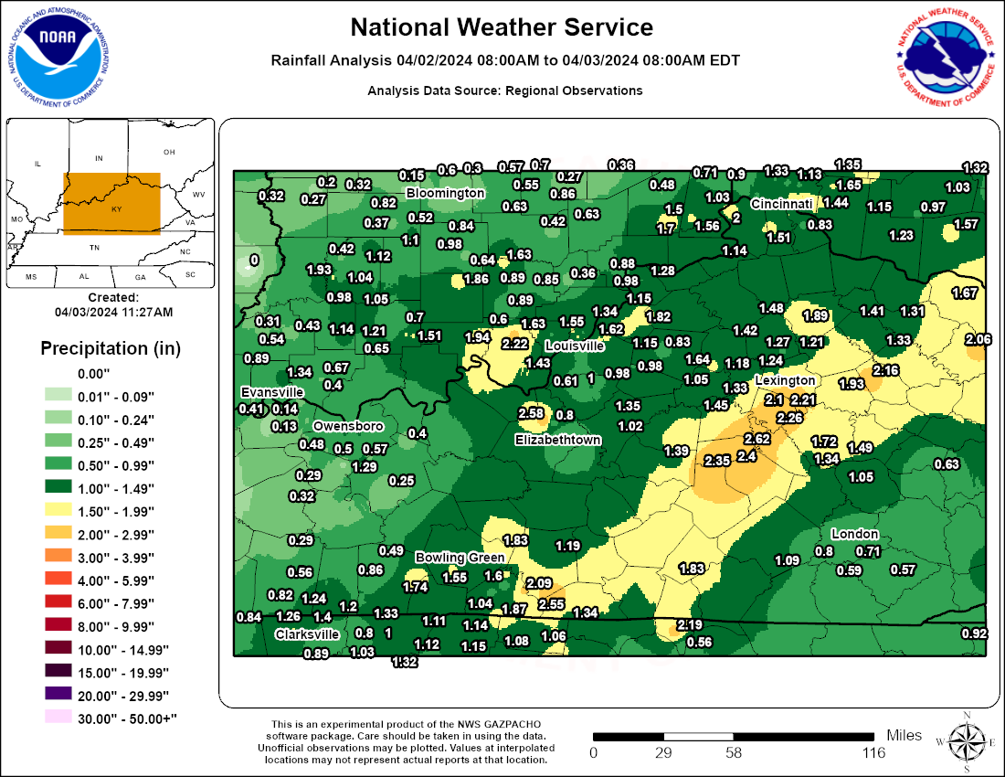
Rain Reports
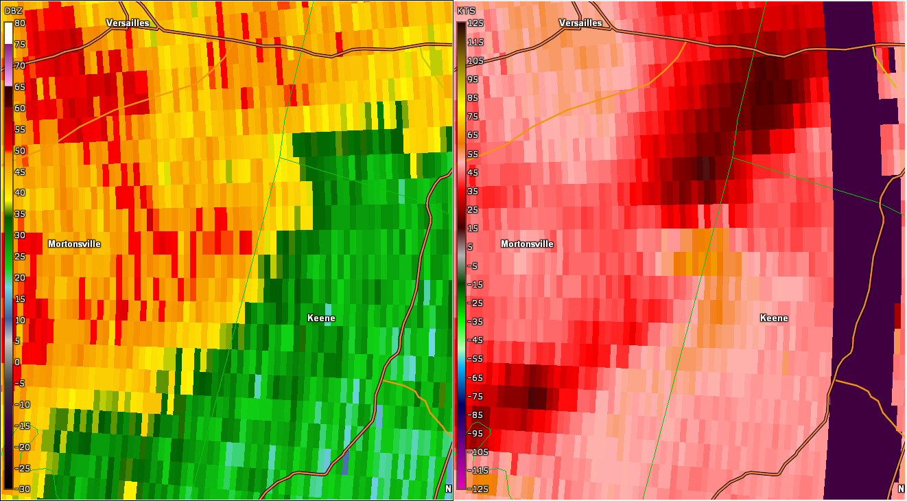
Environment
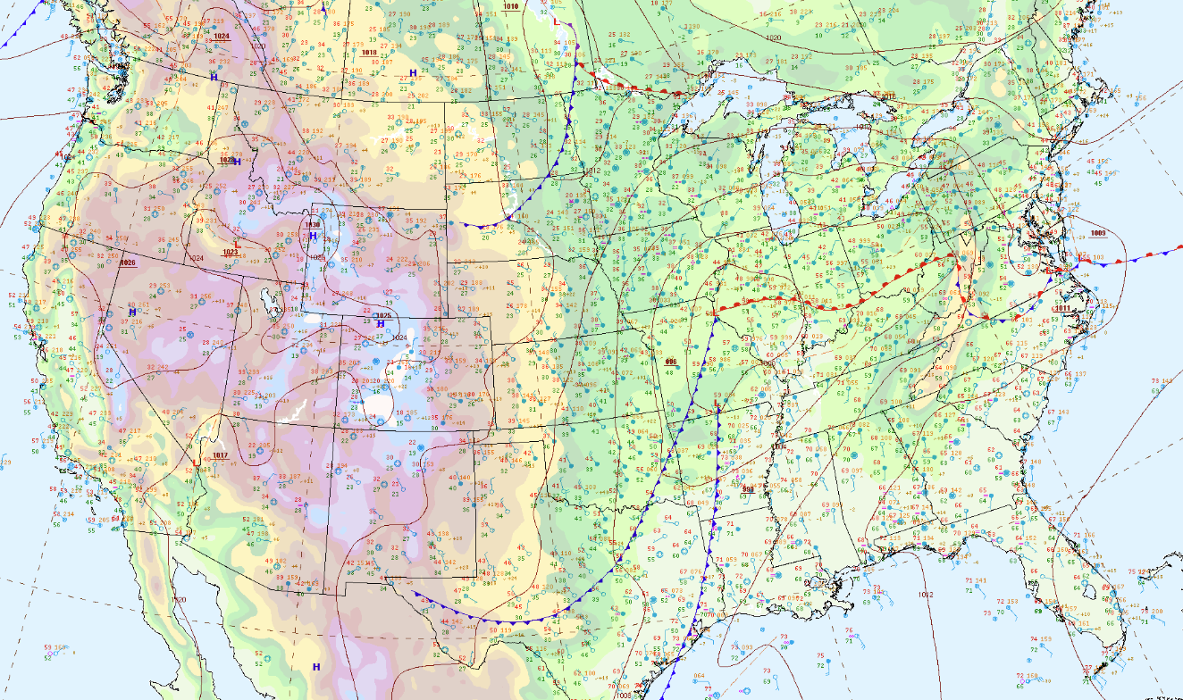 |
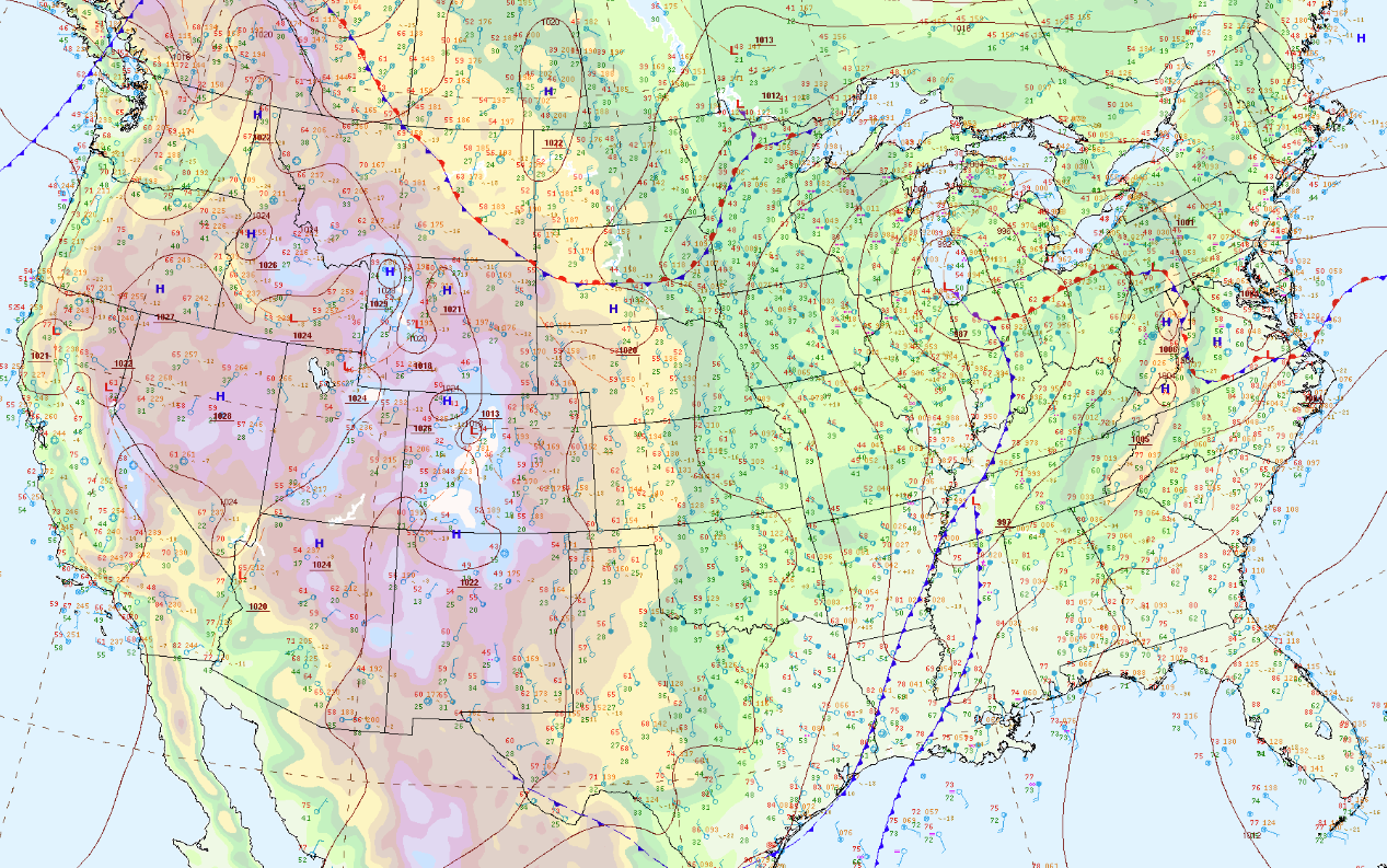 |
| 12Z Surface Map | 21Z Surface Map |
The environment for storm initiation was prime with ample shear, helicity, moisture, and instability.
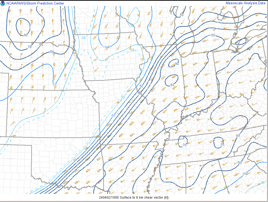 |
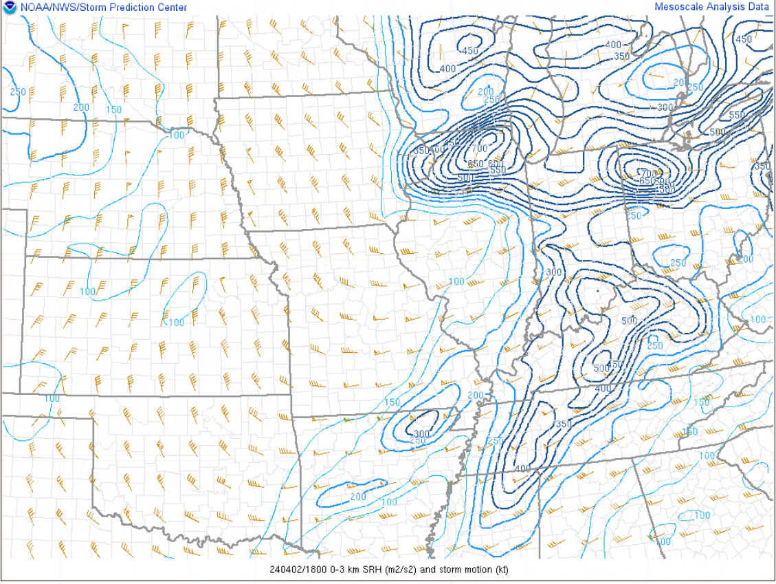 |
 |
| 18Z 0-6km Bulk Shear | 18Z 0-3km SRH | 18Z Surface Based CAPE and CIN |
 |
Media use of NWS Web News Stories is encouraged! Please acknowledge the NWS as the source of any news information accessed from this site. |
|


.png)

Oldham_DAT_Track.png)
 Weather Story
 Weather Map
 Local Radar