Overview
|
Hurricane Helene formed off the Yucatan Peninsula and traveled north through the Gulf of America, strengthening to a Category 4 hurricane before making landfall near Perry, Florida on September 26, 2024 at 11:25 pm EDT. This hurricane traveled at a fast translation speed of 20-30 mph. This fast moving speed allowed the storm to bring hurricane force winds into the southeast U.S. and tropical storm force winds into the Tennessee and Ohio Valleys. Central Kentucky and southern Indiana experienced winds of 40-60 mph winds, with a maximum measured wind of 65 mph at the Lexington Airport in the afternoon of September 27, 2024. The region also received 3-5 inches of rainfall during this event. The post-tropical low pressure system continued to spin over central Kentucky for a few days before moving out of the region. |
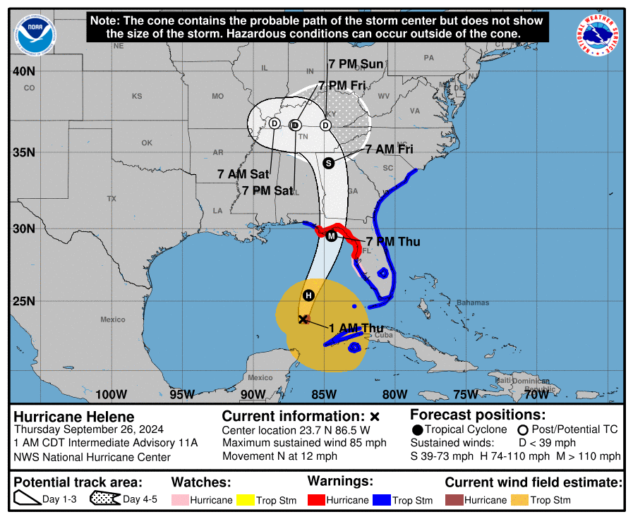 National Hurricane Center Forecast for Hurricane Helene (Issued September 26, 2024 at 12 AM EDT) |
Wind:
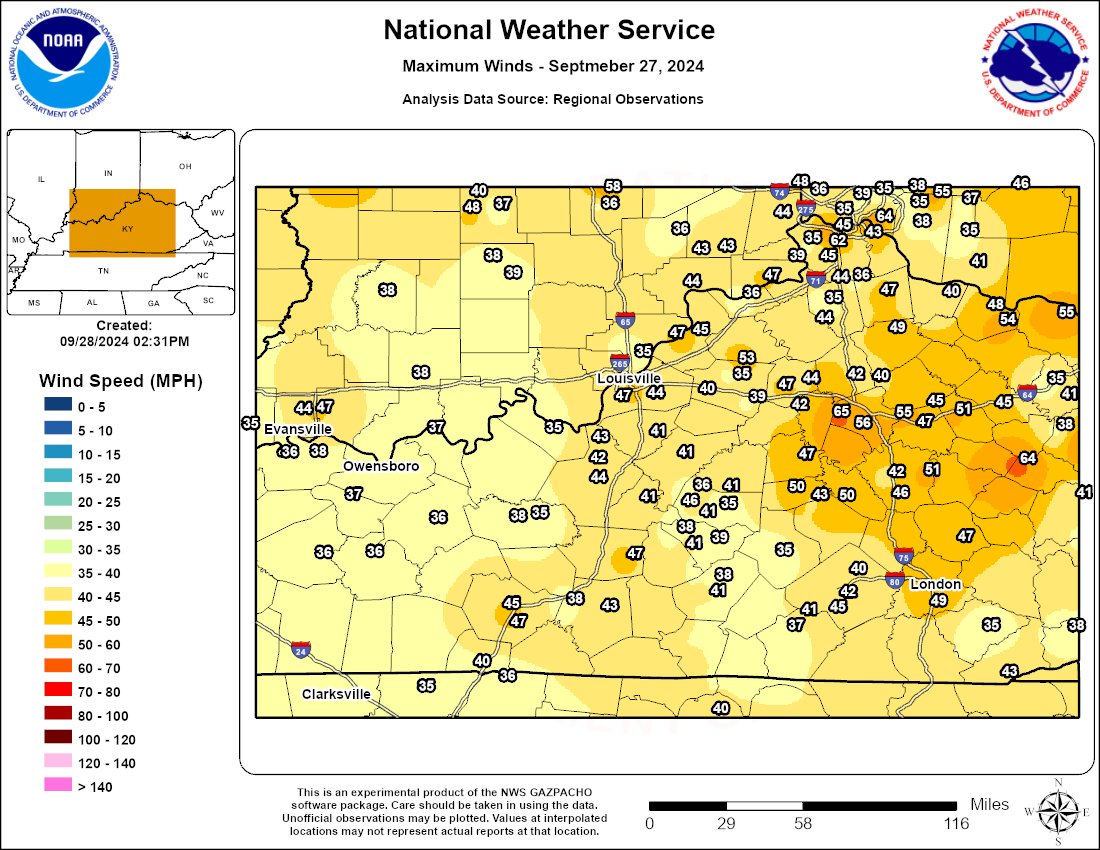 |
| Max Winds on September 27 |
 |
 |
 |
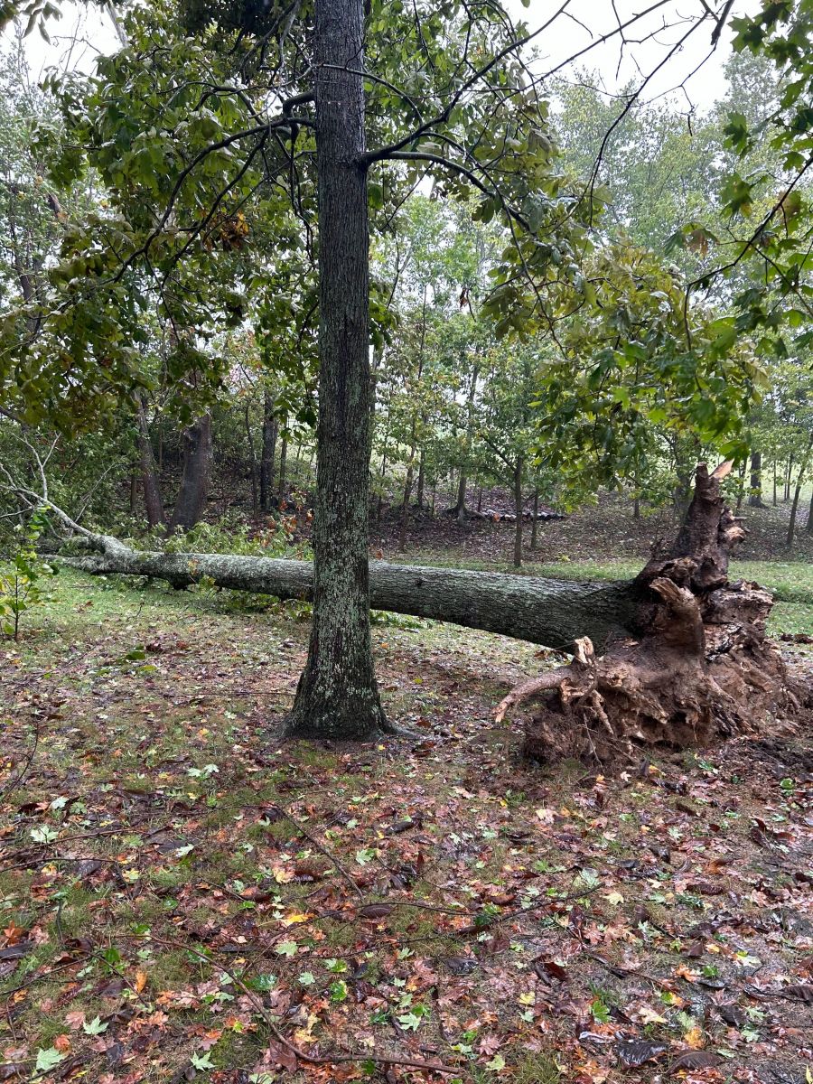 |
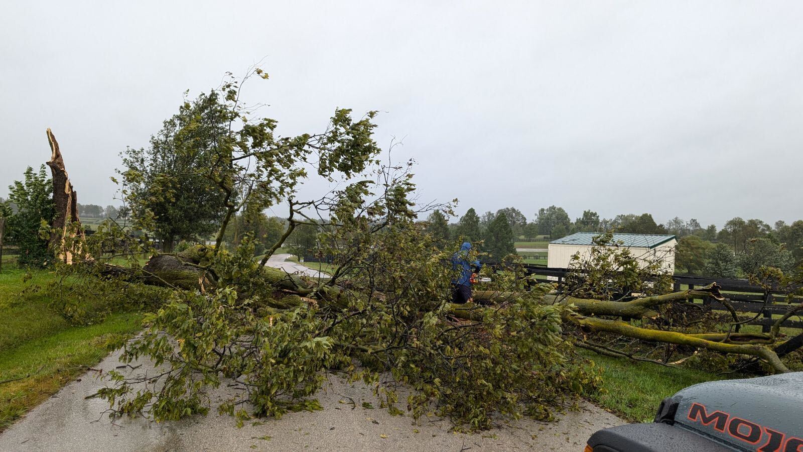
| Shed blown over in Garrard County | Tree down in Scott County | Power Pole down in Scott County | Tree down in Simpsonville |
Storm Reports
Preliminary Local Storm Report...Summary
National Weather Service Louisville KY
1156 PM EDT Sat Sep 28 2024
..TIME... ...EVENT... ...CITY LOCATION... ...LAT.LON...
..DATE... ....MAG.... ..COUNTY LOCATION..ST.. ...SOURCE....
..REMARKS..
1200 PM Non-Tstm Wnd Dmg Versailles 38.05N 84.73W
09/27/2024 Woodford KY Fire Dept/Rescue
Multiple trees down in Woodford County.
Relayed by dispatch.
0115 PM Non-Tstm Wnd Dmg Taylorsville 38.04N 85.34W
09/27/2024 Spencer KY 911 Call Center
Trees down throughout the county.
Approximately 258 power outages reported.
1215 PM Non-Tstm Wnd Gst 2 S Eminence 38.33N 85.17W
09/27/2024 M53 MPH Shelby KY Mesonet
Mesonet station CROP Shelbyville 9 NNE.
Power outages in Shelby County are estimated
at 1,084 during peak gust.
0104 PM Non-Tstm Wnd Dmg 2 SSE Simpsonville 38.20N 85.34W
09/27/2024 Shelby KY Park/Forest Srvc
Large tree uprooted on Buck Creek Road near
Simpsonville, KY.
0132 PM Non-Tstm Wnd Dmg 2 W Waddy 38.12N 85.11W
09/27/2024 Shelby KY Public
Report from mPING: Trees uprooted or
snapped.
0146 PM Non-Tstm Wnd Dmg 4 W Peytona 38.21N 85.13W
09/27/2024 Shelby KY Public
Corrects previous dmg report from 4 W
Peytona. Report from mPING: Trees uprooted
or snapped.
1050 AM Non-Tstm Wnd Dmg 3 WSW Georgetown 38.19N 84.60W
09/27/2024 Scott KY Amateur Radio
Tree down on Neel Lane in SW Georgetown, KY.
1050 AM Non-Tstm Wnd Dmg 2 NE Stamping Ground 38.29N 84.66W
09/27/2024 Scott KY Amateur Radio
Trees knocked down, barn, feeding shed, and
other outbuildings damaged by
non-thunderstorm winds.
1245 PM Non-Tstm Wnd Dmg 2 W Georgetown 38.21N 84.59W
09/27/2024 Scott KY Public
Tree uprooted.
0130 PM Non-Tstm Wnd Dmg 1 S Georgetown 38.19N 84.55W
09/27/2024 Scott KY Amateur Radio
Tree limb knocked a power line onto a shed
behind a residence on Hoover Court. The shed
caught fire due to the live wire and was
destroyed.
1240 PM Non-Tstm Wnd Dmg 2 SSE Pewee Valley 38.29N 85.47W
09/27/2024 Oldham KY Emergency Mngr
Corrects previous report from 2 SSE Pewee
Valley. Ash Ave, near Ash Land Dr, is
completely blocked by a large tree.
1241 PM Non-Tstm Wnd Dmg 2 S Goshen 38.38N 85.59W
09/27/2024 Oldham KY Emergency Mngr
Corrects previous dmg report from 2 S
Goshen. A large tree completely blocking
Mayo Lane near Highway 42 in Goshen.
1245 PM Non-Tstm Wnd Dmg 2 NW Brownsboro 38.37N 85.53W
09/27/2024 Oldham KY Emergency Mngr
Corrects previous dmg report from 2 NW
Brownsboro. Tree into the powerlines and
roadway blocked on Sleepy Hollow Road.
0141 PM Non-Tstm Wnd Dmg 2 NNW Brownsboro 38.38N 85.52W
09/27/2024 Oldham KY Emergency Mngr
Corrects previous tstm wnd dmg report from 2
NNW Brownsboro. Tree blocking Highway 1694
at Harrods Crossing Blvd.
0348 PM Non-Tstm Wnd Dmg 2 NW Pewee Valley 38.33N 85.52W
09/27/2024 Oldham KY Public
Corrects previous dmg report from 2 NW Pewee
Valley. Report from mPING: Trees uprooted or
snapped.
0115 PM Non-Tstm Wnd Gst 1 NNW Carlisle 38.32N 84.04W
09/27/2024 M57 MPH Nicholas KY Mesonet
Mesonet station CARL. Approximately 1,641
power outages in Nicholas County.
1230 PM Non-Tstm Wnd Dmg 4 E Shakertown 37.81N 84.80W
09/27/2024 Mercer KY Trained Spotter
Large tree limb down blocking roadway near
intersection of Curry Pike and Chinn Lane.
1241 PM Non-Tstm Wnd Dmg 3 E Shakertown 37.81N 84.80W
09/27/2024 Mercer KY Public
Large tree limb blocking Curry Pike near
intersection of Chinn Lane.
0108 PM Non-Tstm Wnd Dmg 2 ESE Shakertown 37.81N 84.83W
09/27/2024 Mercer KY Public
Large tree limbs down across Warwick Road in
Mercer County.
1120 AM Non-Tstm Wnd Gst 1 S Waco 37.72N 84.15W
09/27/2024 M51 MPH Madison KY Mesonet
1218 PM Non-Tstm Wnd Dmg 5 SW Trapp 37.84N 84.12W
09/27/2024 Madison KY Amateur Radio
Report of a tree down on a deck on Black
Road near College Hill Road. A couple of
trees down across roads in the area.
1236 PM Non-Tstm Wnd Dmg 2 W Richmond 37.74N 84.33W
09/27/2024 Madison KY Public
Tree snapped in front of Chick-Fil-A at the
Richmond Centre location.
0102 PM Non-Tstm Wnd Dmg 4 WSW Richmond 37.72N 84.35W
09/27/2024 Madison KY Amateur Radio
Few trees down throughout the area.
1100 AM Non-Tstm Wnd Dmg Stanford 37.53N 84.66W
09/27/2024 Lincoln KY Fire Dept/Rescue
Multiple trees down in Lincoln County -
relayed by dispatch.
0225 PM Rain 2 E Hodgenville 37.57N 85.70W
09/27/2024 M3.68 Inch Larue KY Mesonet
3.68 inches of rain measured in the past 24
hours in LaRue County.
1200 PM Non-Tstm Wnd Dmg Nicholasville 37.88N 84.58W
09/27/2024 Jessamine KY Fire Dept/Rescue
Multiple trees down in Jessamine County,
relayed by dispatch.
0415 PM Non-Tstm Wnd Dmg 1 SSE Nicholasville 37.87N 84.58W
09/27/2024 Jessamine KY Public
Social media photo shows a church steeple
has been blown off the roof of the building.
1130 AM Non-Tstm Wnd Dmg 903 Lake Forest Parkway 38.26N 85.49W
09/27/2024 Jefferson KY NWS Employee
Large pine tree down.
0153 PM Non-Tstm Wnd Dmg 2 ENE Middletown 38.25N 85.49W
09/27/2024 Jefferson KY Emergency Mngr
Large tree down on Lake Forest Pkwy and
blocking the road.
0312 PM Non-Tstm Wnd Dmg 2 S Pleasure Ridge Par 38.13N 85.86W
09/27/2024 Jefferson KY Public
Tree down on garage near West Pages Lane.
0730 AM Non-Tstm Wnd Dmg 1 ENE Horse Cave 37.18N 85.90W
09/27/2024 Hart KY Emergency Mngr
Tree blocking Steen Ave.
0130 PM Non-Tstm Wnd Gst 3 SE Berry 38.50N 84.35W
09/27/2024 M49 MPH Harrison KY Mesonet
Mesonet station RBSN Cynthiana 8 N.
Approximately 2,838 power outages in
Harrison County.
1115 AM Non-Tstm Wnd Dmg 3 S Elizabethtown 37.65N 85.86W
09/27/2024 Hardin KY NWS Employee
Tree down on power lines...power out south
of town.
1248 PM Non-Tstm Wnd Dmg Elizabethtown 37.71N 85.87W
09/27/2024 Hardin KY Amateur Radio
Tree fallen on house on Cherrywood Drive in
Elizabethtown.
1159 PM Rain 2 S Vine Grove 37.79N 85.98W
09/27/2024 M3.77 Inch Hardin KY NWS Employee
24 hour rain total of 3.77 inches.
1100 AM Non-Tstm Wnd Dmg Lancaster 37.62N 84.58W
09/27/2024 Garrard KY Fire Dept/Rescue
Multiple trees down in Garrard County,
relayed by dispatch.
1244 PM Non-Tstm Wnd Dmg 5 E Danville 37.65N 84.69W
09/27/2024 Garrard KY Public
Report from mPING: Trees uprooted or
snapped.
0218 PM Non-Tstm Wnd Dmg 3 SSE Lancaster 37.58N 84.56W
09/27/2024 Garrard KY Trained Spotter
Large tree branch down on house in Garrard
County.
1230 PM Non-Tstm Wnd Dmg 1 WSW Frankfort 38.19N 84.87W
09/27/2024 Franklin KY Public
Multiple trees down in Frankfort.
1238 PM Non-Tstm Wnd Dmg 1 WNW Forks of Elkhorn 38.22N 84.82W
09/27/2024 Franklin KY Trained Spotter
Large tree limb down in road at the
intersection of Powhatan Trail and Chinook
Trail.
0200 PM Non-Tstm Wnd Dmg 2 W Frankfort 38.19N 84.90W
09/27/2024 Franklin KY Public
Delayed report. Social media photo shows
large tree down at intersection of Pierce Ln
and Holly Hill Drive.
1016 AM Non-Tstm Wnd Gst 6 W Lexington 38.04N 84.61W
09/27/2024 M54 MPH Fayette KY ASOS
1055 AM Non-Tstm Wnd Gst 6 SSW Lexington 37.97N 84.53W
09/27/2024 M51 MPH Fayette KY Mesonet
1152 AM Non-Tstm Wnd Gst 5 W Lexington 38.03N 84.60W
09/27/2024 M61 MPH Fayette KY ASOS
ASOS station KLEX Lexington.
1245 PM Non-Tstm Wnd Dmg 1 SSW Lexington 38.03N 84.51W
09/27/2024 Fayette KY Dept of Highways
Nicholasville Road closed between Alumni
Drive and Cooper Drive due to downed power
lines. Approximately 33,856 power outages
reported.
0530 PM Non-Tstm Wnd Dmg 1 S Mammoth Cave 37.19N 86.10W
09/27/2024 Edmonson KY Amateur Radio
Multiple trees down on roads in the Mammoth
Cave area.
1205 PM Non-Tstm Wnd Gst 3 NNW Winchester 38.03N 84.21W
09/27/2024 M53 MPH Clark KY Mesonet
Mesonet station WNCH Winchester 3 NW.
1100 AM Non-Tstm Wnd Dmg Liberty 37.32N 84.93W
09/27/2024 Casey KY Fire Dept/Rescue
Multiple trees down in Casey County -
relayed by dispatch.
0100 PM Non-Tstm Wnd Dmg 1 NE Mount Washington 38.06N 85.53W
09/27/2024 Bullitt KY Trained Spotter
Two maple trees down in a front yard in
Mount Washington.
1200 PM Non-Tstm Wnd Gst 3 WSW Danville 37.62N 84.82W
09/27/2024 M50 MPH Boyle KY Mesonet
Mesonet station DANV Danville 3 SW.
0520 PM Non-Tstm Wnd Dmg Parksville 37.60N 84.90W
09/27/2024 Boyle KY Dept of Highways
Tree down near KY 1822.
0522 PM Non-Tstm Wnd Dmg 2 SSW Nevada 37.68N 84.93W
09/27/2024 Boyle KY Dept of Highways
Tree down on US 68.
1216 PM Non-Tstm Wnd Dmg 1 S Tyrone 38.02N 84.85W
09/27/2024 Anderson KY Dept of Highways
Several trees down on Wildcat Road in
Anderson County. Power outages are estimated
at 1,168 in Anderson County.
0147 PM Non-Tstm Wnd Dmg 1 SE Tyrone 38.02N 84.84W
09/27/2024 Anderson KY Public
Corrects previous dmg report from 1 SE
Tyrone. Report from mPING: Trees uprooted or
snapped.
1153 AM Non-Tstm Wnd Dmg 1 WNW Salem 38.61N 86.11W
09/27/2024 Washington IN Emergency Mngr
Tree fell into a power pole causing it to
snap. The power pole fell into a house.
1230 PM Non-Tstm Wnd Dmg 1 WNW Salem 38.61N 86.12W
09/27/2024 Washington IN Emergency Mngr
Tree has fallen onto a house at 112
Washington Blvd.
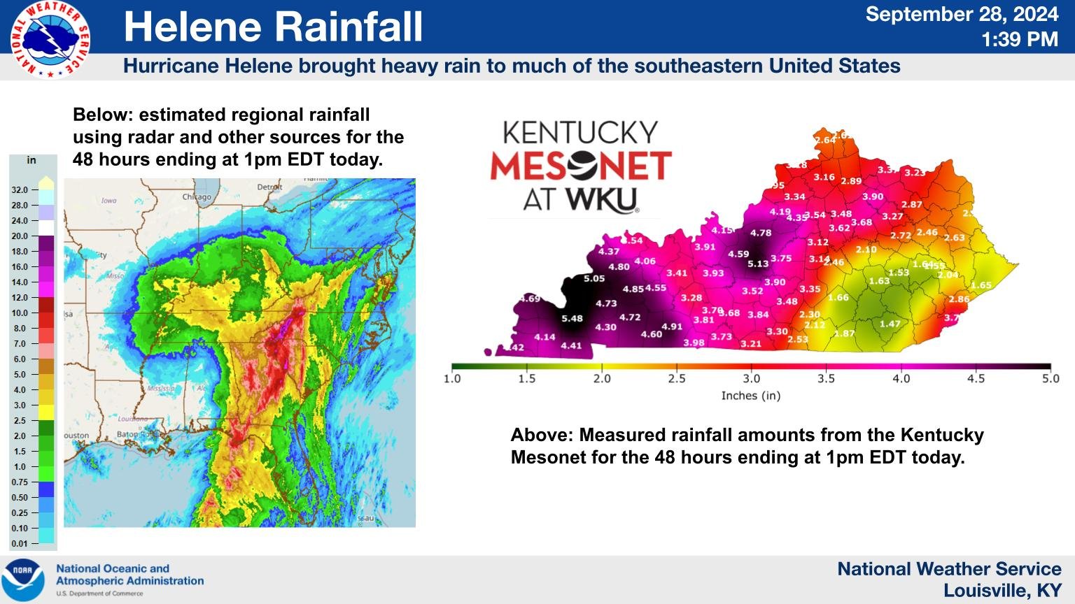
Rainfall
2-4 inches of rain fell on September 27, 2024.
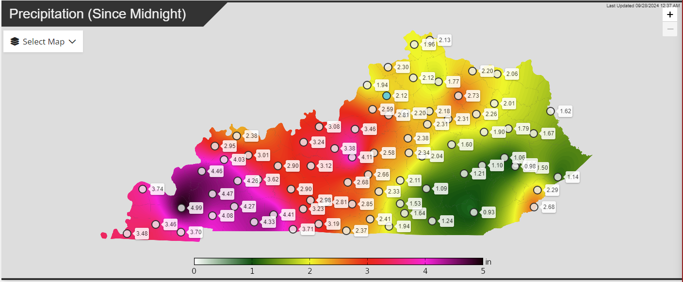 |
| 24 hour rainfall on September 27 from the KY Mesonet |
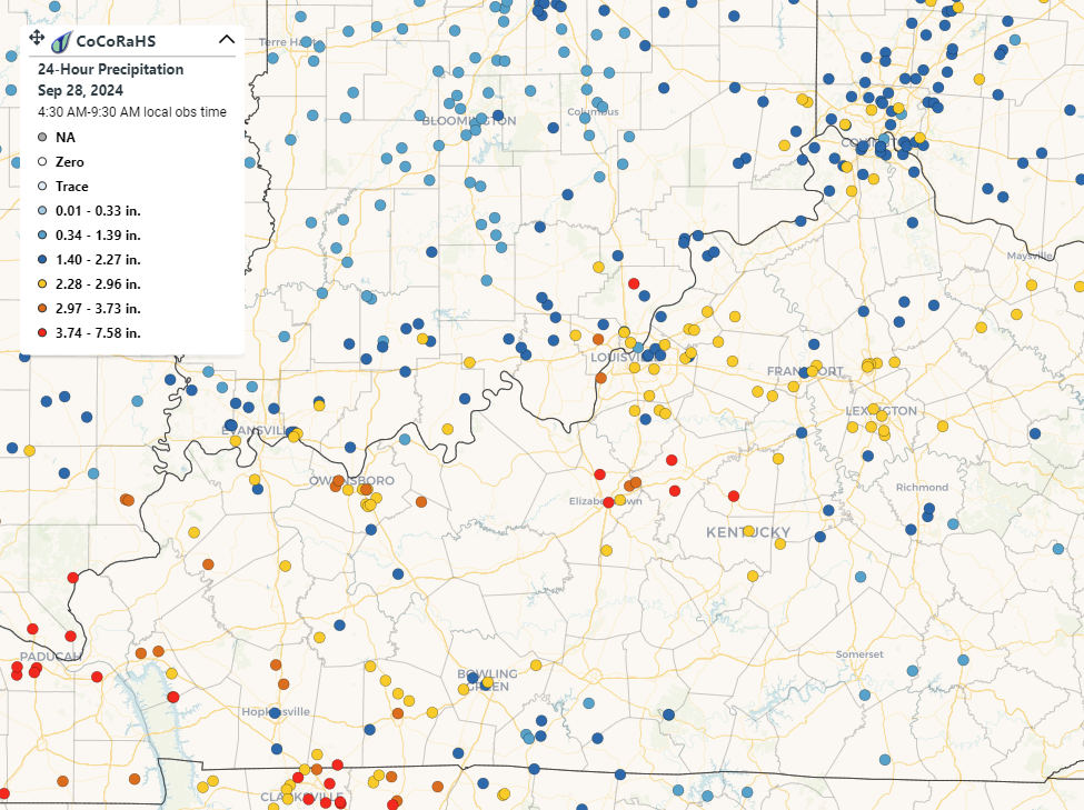 |
| 24 hour rainfall on September 27 from CoCoRaHS |
Hurricane Helene History
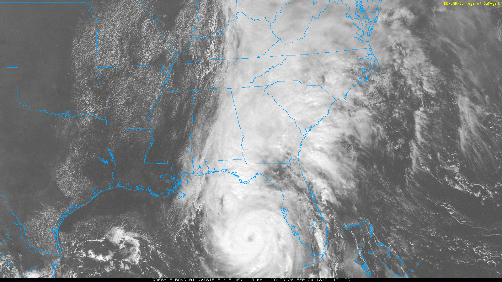
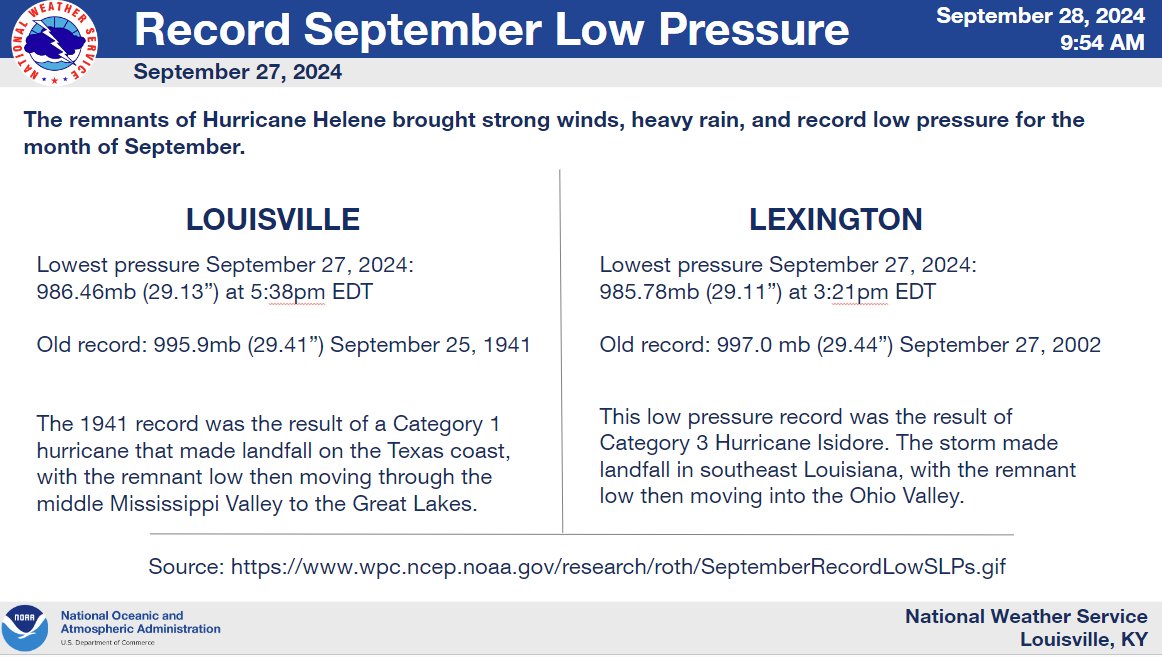
Hurricane Helene strengthened to a Category 4 hurricane before making landfall near Perry, Florida. This is the largest and strongest storm to ever hit the Big Bend area of Florida. Also, this was the highest recorded storm surge at the Cedar Key gauge. This storm led to catastrophic flooding in the western Carolinas. In central Kentucky and southern Indiana, it brought 2-4 inches of rain, winds up to 65 mph, and record breaking minimum pressure for the month of September. The remnants of Hurricane Helene continued to spin over the Ohio Valley through the weekend, before moving off to the east.
 |
 |
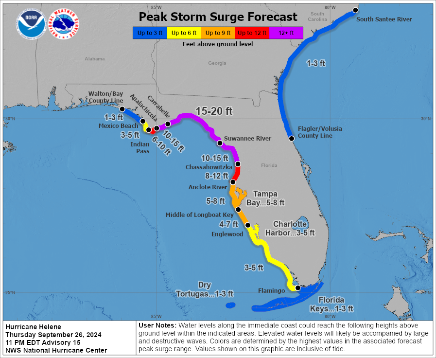 |
| Infrared Satellite just before landfall | Satellite Loop just before landfall | Record storm surge recorded |
 |
 |
|
| Total rainfall due with Hurricane Helene | Record breaking minimum pressure for September | Wind gusts over the Ohio Valley |
 |
Media use of NWS Web News Stories is encouraged! Please acknowledge the NWS as the source of any news information accessed from this site. |
|


 Weather Story
 Weather Map
 Local Radar