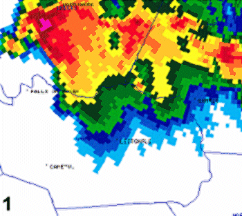
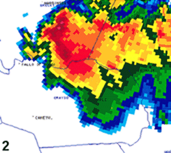
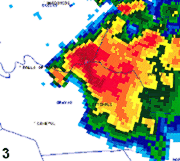
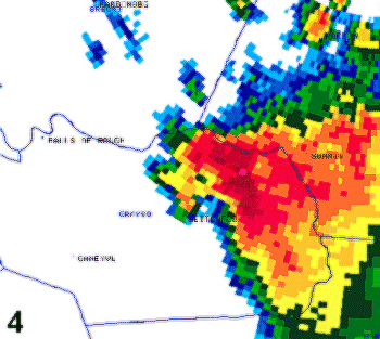
| During the afternoon and evening of May 23, 2000, numerous severe thunderstorms moved southeast across central Kentucky resulting in many reports of large hail, wind damage, and a few tornadoes. Convective structure included several supercell storms, as strong vertical wind shear in the atmosphere (south-southwest surface winds and stronger west-northwest winds aloft) and ample instability combined to produce rapid storm organization and periodic storm rotation. One supercell in particular moved across Breckinridge and Grayson counties in north-central Kentucky (50-60 miles southwest of Louisville) during the afternoon hours. This storm produced golfball to baseball size hail in Breckinridge County. It then generated a tornado over Grayson County which struck the Leitchfield area around 200 pm CDT (300 pm EDT) producing substantial damage to numerous structures and homes in the region. The tornado produced F3 damage (on the Fujita scale) at its maximum intensity in Leitchfield. Other portions of the area received F1 and F2 damage. Below is a series of Doppler radar images from the Ft. Knox-NWS Louisville (KLVX) WSR-88D showing the overall evolution of this storm. |
 |
 |
 |
 |
 |
 |
 |
 |
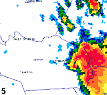
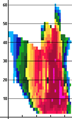
This series of base reflectivity data from the KLVX WSR-88D Doppler radar shows the supercell thunderstorm about every 10 minutes on its movement from Breckinridge County (image 1) to eastern Grayson, southwest Hardin, and northwest Hart counties (image 5). A hook echo was present on the southwest edge of the storm, signifying the location of the tornado across Grayson County. Image 4 shows the storm at the time the tornado was on the ground near Leitchfield. To the north and east of the hook, the dark red and pink colors denoted the location of large hail and torrential rain in the storm. Golfball to baseball size hail was reported with the storm in Breckinridge County with golfball hail also noted in northern/eastern Grayson County. |
|
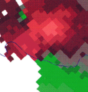
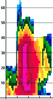
ABOVE: Low-level storm-relative motion (SRM) from the KLVX WSR-88D radar. Green (red) color denotes storm-relative winds directed toward (away from) the radar located at Ft. Knox northeast of the area shown. A counterclockwise (cyclonic) circulation was noted along the Breckinridge-Grayson county border indicating a developing tornado, with strong inflow over southern Breckinridge directed toward the hook echo. This image corresponds to image 3 above. BELOW: Reflectivity cross-section of the supercell in western Breckinridge County (prior to image 1 above), which allowed a vertical assessment of the storm. Deep, intense convection was present with echo tops above 50,000 feet and a deep suspended core of very high reflectivity (60-70 dBZ) up to 40,000 feet. Thus, a strong rotating updraft was present in the storm, which produced golfball to baseball size hail at this time, prior to tornado production. |
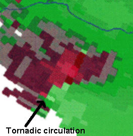
ABOVE: SRM image 20-25 minutes later corresponding to reflectivity image 4 above. The low-level circulation (part of a deep-layered mesocyclone) (labeled above) intensified rapidly across Grayson County resulting in the occurrence of the tornado in Leitchfield at this time. The mesocyclone was identified as adjacent light red (left;outbound) and light green (right;inbound) pixels. Strong storm-relative flow continued to be directed into the mesocyclone. BELOW: About 15 minutes later, the storm, now in southern Breckinridge County, remained intense with echo tops around 55,000 feet. Deep-layered, high reflectivity values remained suspended in the storm up to nearly 50,000 feet. The storm continued to produce golfball size hail at this time. Lower reflectivity values from about 20,000-40,000 feet on the left side of the image represented precipitation returns in the anvil portion of the thunderstorm. |
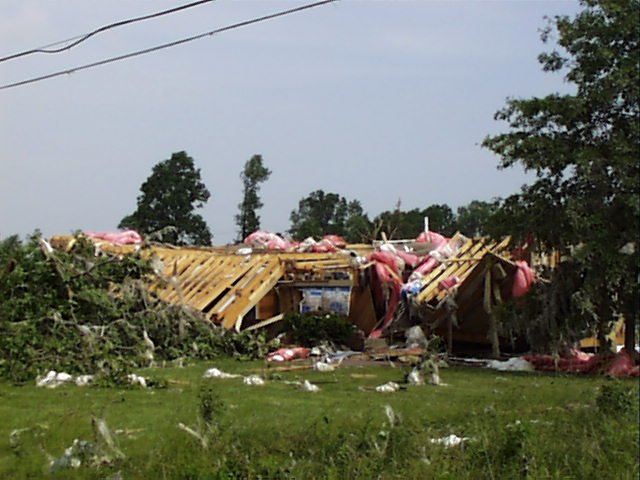
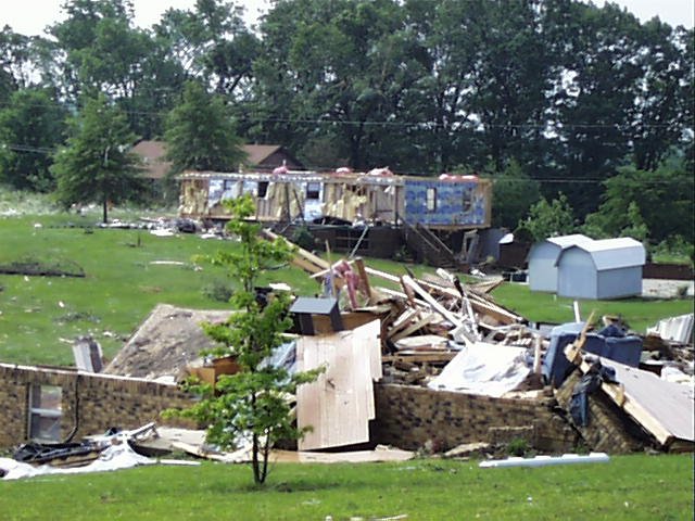
Damage pictures (above/below) from Leitchfield, KY caused by the supercell tornado on May 23, 2000. |
 |
 |
 |


 Weather Story
 Weather Map
 Local Radar