Overview
|
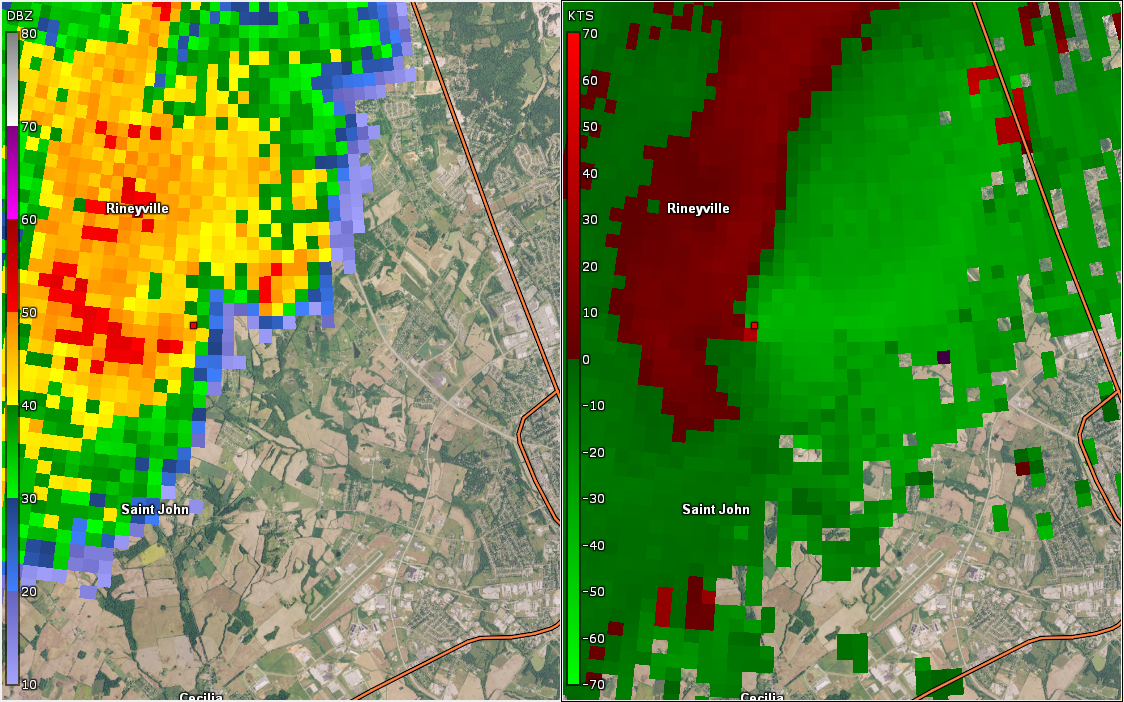
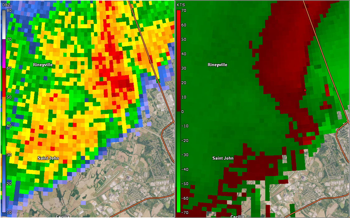
A cluster of storms ahead of a cold front moved through central Kentucky on Halloween evening. These storms caused flooding, strong winds, and an EF-1 tornado south of Rineyville in Hardin County, KY. Halloween Tornado Climate Fact: The last tornado that touched down on October 31 was an F2 in Casey County, KY in 1934. |
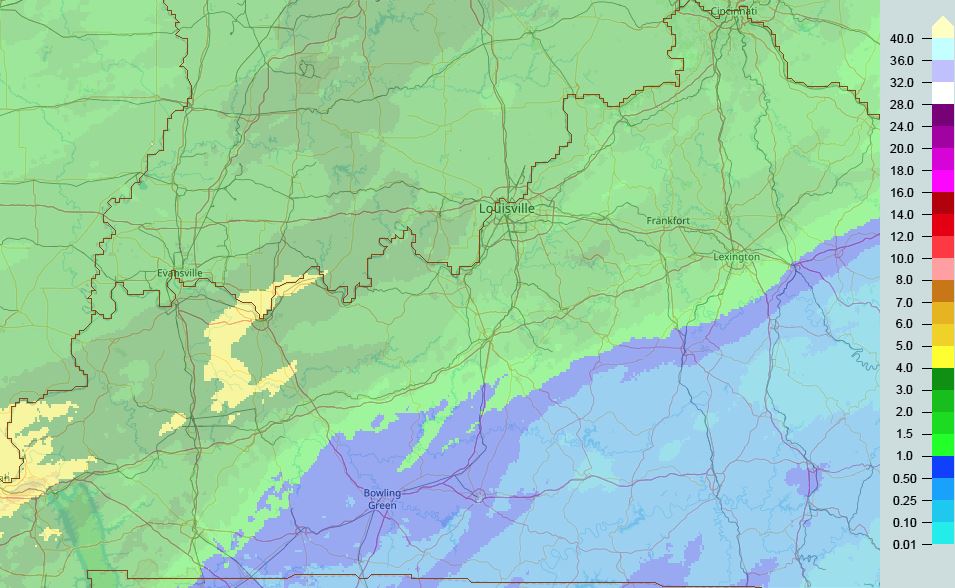
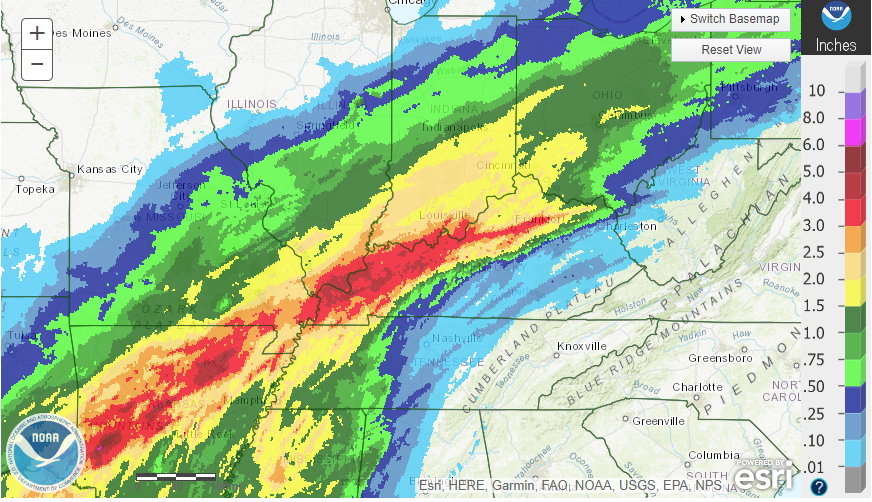 Regional Rainfall 10/31-11/1/2018 |
Tornado:
|
|
||||||||||
|
||||||||||
|
Rineyville, KY
Track Map 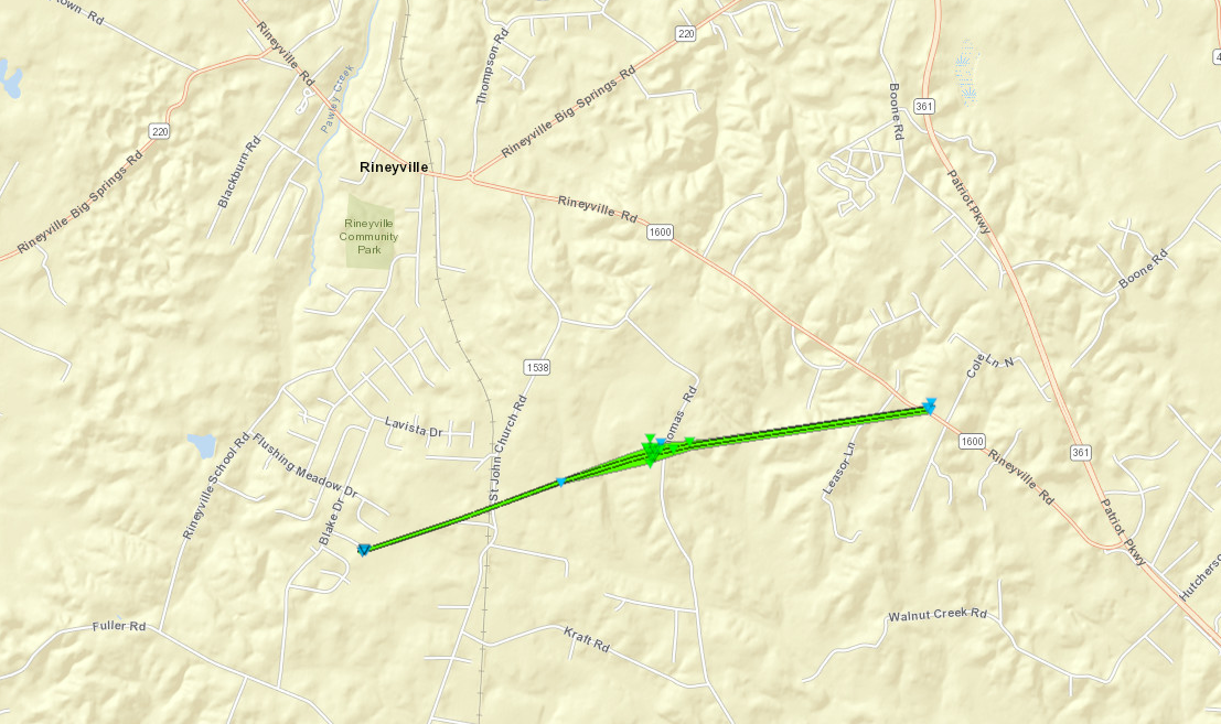 
|
||||||||||||||||
|
||||||||||||||||
The Enhanced Fujita (EF) Scale classifies tornadoes into the following categories:
| EF0 Weak 65-85 mph |
EF1 Moderate 86-110 mph |
EF2 Significant 111-135 mph |
EF3 Severe 136-165 mph |
EF4 Extreme 166-200 mph |
EF5 Catastrophic 200+ mph |
 |
|||||
Flooding
Hydrographs
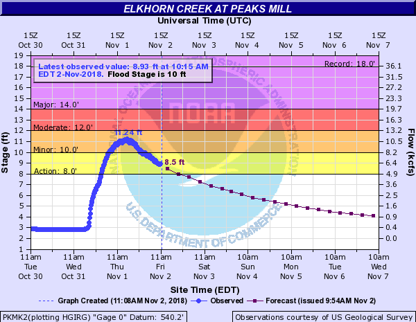 |
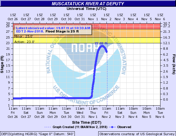 |
| Elkhorn Creek at Peaks Mill, KY, went into flood stage | Muscatatuck River at Deputy, IN, came close to flood stage, with a fast rise. |
Radar/Photos
 |
| An estimate of total rainfall using gauges and radar data from the MRMS (Multi-Radar Multi-Sensor) database |
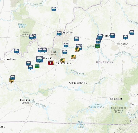
Storm Reports:
 |
0500 PM     HEAVY RAIN       2 N GEORGETOWN          38.23N 84.55W
10/31/2018  M1.74 INCH       SCOTT              KY   COCORAHS

            1.74 INCHES SINCE 1:30 PM.

0508 PM     HEAVY RAIN       TELL CITY               37.95N 86.76W
10/31/2018  M1.90 INCH       PERRY              IN   TRAINED SPOTTER


0513 PM     HEAVY RAIN       1 E FRANKFORT           38.19N 84.84W
10/31/2018  M2.50 INCH       FRANKLIN           KY   PUBLIC


0530 PM     TSTM WND DMG     BEAVER DAM              37.41N 86.88W
10/31/2018                   OHIO               KY   EMERGENCY MNGR

            4 TREES AND MULTIPLE POWER LINES DOWN.

0539 PM     TSTM WND DMG     1 SSE RINEYVILLE        37.73N 85.95W
10/31/2018                   HARDIN             KY   EMERGENCY MNGR

            CORRECTS PREVIOUS TSTM WND DMG REPORT FROM 1
            SSE RINEYVILLE. SEVERAL BUILDINGS DAMAGED
            AND TREES DOWN.

0539 PM     TORNADO          2 SSW RINEYVILLE        37.73N 85.98W
10/31/2018                   HARDIN             KY   NWS STORM SURVEY

            EF-1 TORNADO 2.5 MILES LONG/80 YARDS WIDE
            WITH MAX WINDS OF 100 MPH DAMAGED
            OUTBUILDINGS, ROOFS/SIDING ON HOMES, A
            TRAVEL TRAILER, AND ANOTHER VEHICLE SOUTH OF
            RINEYVILLE.

0540 PM     HEAVY RAIN       3 E TAYLORSVILLE        38.04N 85.30W
10/31/2018  M1.96 INCH       SPENCER            KY   PUBLIC


0545 PM     HEAVY RAIN       2 NNE GEORGETOWN        38.22N 84.54W
10/31/2018  M2.25 INCH       SCOTT              KY   EMERGENCY MNGR

            MULTIPLE AUTOMOBILE ACCIDENTS REPORTED BY
            EMA FROM PEOPLE HYDROPLANING ON INTERSTATE
            75 NEAR GEORGETOWN. A NEARBY COCORAHS
            OBSERVER REPORTED TOTAL RAINFALL OF 2.25
            INCHES THIS AFTERNOON.

0603 PM     TSTM WND DMG     2 WSW BOSTON            37.77N 85.70W
10/31/2018                   NELSON             KY   911 CALL CENTER

            TREE DOWN BLOCKING BOSTON RD NEAR THE HARDIN
            COUNTY LINE. TIME ESTIMATED FROM RADAR.

0624 PM     TSTM WND DMG     1 ENE NAZARETH          37.84N 85.45W
10/31/2018                   NELSON             KY   911 CALL CENTER

            TREE DOWN BLOCKING VIRGINIA AVE. TIME
            ESTIMATED FROM RADAR.

0640 PM     TSTM WND DMG     3 NNE FAIRFIELD         37.97N 85.36W
10/31/2018                   SPENCER            KY   EMERGENCY MNGR

            CORRECTS PREVIOUS TSTM WND DMG REPORT FROM 3
            NNE FAIRFIELD. 1 TREE DOWN. WATER OVER SOME
            ROADS THAT TYPICALLY FLOOD.

0800 PM     HEAVY RAIN       2 N GEORGETOWN          38.23N 84.55W
10/31/2018  M2.91 INCH       SCOTT              KY   COCORAHS

            STORM TOTAL SINCE 130 PM EDT.

1000 PM     HEAVY RAIN       TAYLORSVILLE            38.03N 85.34W
10/31/2018  M2.78 INCH       SPENCER            KY   TRAINED SPOTTER


1026 PM     HEAVY RAIN       3 WNW MILLVILLE         38.15N 84.87W
10/31/2018  M4.37 INCH       FRANKLIN           KY   TRAINED SPOTTER


1125 PM     HEAVY RAIN       1 E FRANKFORT           38.19N 84.85W
10/31/2018  M3.80 INCH       FRANKLIN           KY   PUBLIC


0200 AM     FLOOD            1 N HUDSON              37.67N 86.29W
11/01/2018                   BRECKINRIDGE       KY   911 CALL CENTER

            FAIRFIELD-HUDSON ROAD CLOSED.

0600 AM     HEAVY RAIN       3 SSW DOE VALLEY        37.96N 86.12W
11/01/2018  M2.97 INCH       MEADE              KY   CO-OP OBSERVER

            24 HOUR RAINFALL.

0600 AM     HEAVY RAIN       2 W FORKS OF ELKHORN    38.22N 84.83W
11/01/2018  M2.60 INCH       FRANKLIN           KY   CO-OP OBSERVER

            24 HOUR RAINFALL.

0700 AM     HEAVY RAIN       1 WNW TELL CITY         37.95N 86.77W
11/01/2018  E3.89 INCH       PERRY              IN   CO-OP OBSERVER

            24 HOUR RAINFALL.

0700 AM     HEAVY RAIN       1 NW LEAVENWORTH        38.21N 86.36W
11/01/2018  M3.12 INCH       CRAWFORD           IN   CO-OP OBSERVER

            24 HOUR RAINFALL.

0700 AM     HEAVY RAIN       2 NNW WAKEFIELD         38.00N 85.31W
11/01/2018  M2.98 INCH       SPENCER            KY   CO-OP OBSERVER

            TAYLORSVILLE LAKE 24 HOUR RAINFALL.

0700 AM     HEAVY RAIN       3 W BIG SPRING          37.79N 86.23W
11/01/2018  E2.72 INCH       BRECKINRIDGE       KY   CO-OP OBSERVER

            24 HOUR RAINFALL.

0700 AM     HEAVY RAIN       4 ESE HILLVIEW          38.05N 85.62W
11/01/2018  M2.65 INCH       BULLITT            KY   CO-OP OBSERVER

            24 HOUR RAINFALL.

0700 AM     HEAVY RAIN       BEECHWOOD               38.20N 86.42W
11/01/2018  M2.47 INCH       CRAWFORD           IN   CO-OP OBSERVER

            24 HOUR RAINFALL.

0700 AM     HEAVY RAIN       1 E PARIS               38.20N 84.24W
11/01/2018  M2.18 INCH       BOURBON            KY   CO-OP OBSERVER


0700 AM     HEAVY RAIN       1 NW LOUISVILLE         38.27N 85.78W
11/01/2018  M2.00 INCH       JEFFERSON          KY   OTHER FEDERAL

            24 HOUR RAINFALL AT MCALPINE LOCK AND DAM.

0859 AM     HEAVY RAIN       2 ENE HARTFORD          37.46N 86.85W
11/01/2018  M3.35 INCH       OHIO               KY   MESONET

            24 HOUR RAINFALL.

0900 AM     HEAVY RAIN       ROFF                    37.65N 86.44W
11/01/2018  M3.86 INCH       BRECKINRIDGE       KY   CO-OP OBSERVER

            24 HOUR RAINFALL.

0901 AM     HEAVY RAIN       4 WSW MILLVILLE         38.12N 84.88W
11/01/2018  M2.91 INCH       FRANKLIN           KY   MESONET

            KENTUCKY MESONET 24 HOUR RAINFALL.

0902 AM     HEAVY RAIN       3 NW EKRON              37.96N 86.22W
11/01/2018  M2.88 INCH       MEADE              KY   MESONET

            KENTUCKY MESONET 24 HOUR RAINFALL.

0904 AM     HEAVY RAIN       2 NE MCQUADY            37.72N 86.49W
11/01/2018  M2.73 INCH       BRECKINRIDGE       KY   MESONET

            KENTUCKY MESONET 24 HOUR RAINFALL.

0905 AM     HEAVY RAIN       3 ESE MILLERSBURG       38.28N 84.10W
11/01/2018  M2.58 INCH       NICHOLAS           KY   MESONET

            KENTUCKY MESONET 24 HOUR RAINFALL.

0907 AM     HEAVY RAIN       1 N CLERMONT            37.93N 85.65W
11/01/2018  M2.31 INCH       BULLITT            KY   MESONET

            KENTUCKY MESONET 24 HOUR RAINFALL.

0930 AM     FLOOD            LAWRENCEBURG            38.04N 84.89W
11/01/2018                   ANDERSON           KY   EMERGENCY MNGR

            SOME LOW WATER CROSSINGS WITH WATER OVER
            THEM.

1008 AM     HEAVY RAIN       4 SSW SIMPSONVILLE      38.17N 85.38W
11/01/2018  M2.02 INCH       SHELBY             KY   MESONET

            KENTUCKY MESONET 24 HOUR RAINFALL.

1024 AM     HEAVY RAIN       1 N LITTLE YORK         38.71N 85.90W
11/01/2018  M2.20 INCH       WASHINGTON         IN   PUBLIC
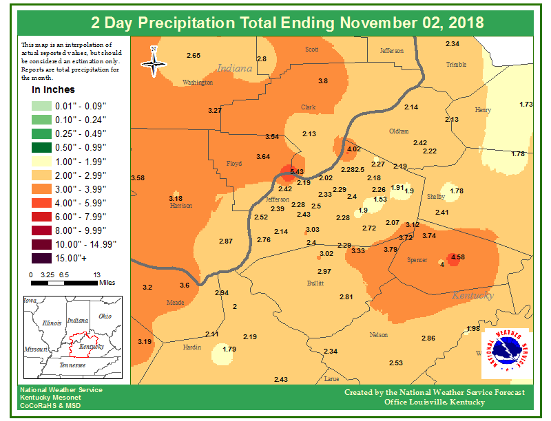
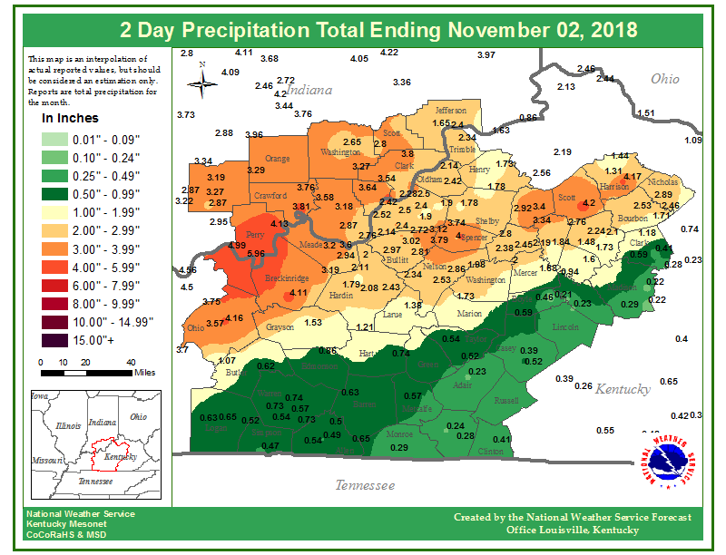
Rain Reports
 |
 |
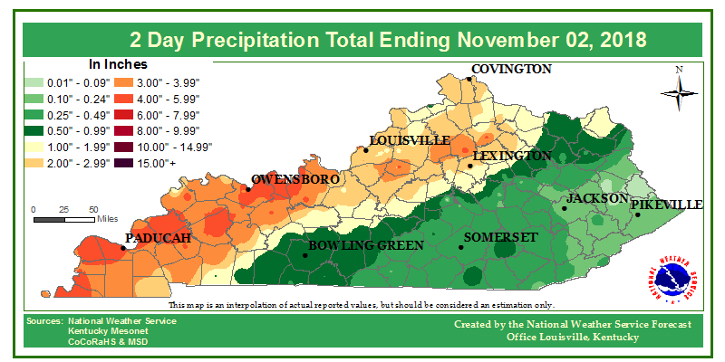 |
| Figure 1: 2-day rainfall total for the Louisville metro area | Figure 2: 2-day rainfall totals for the NWS Louisville county warning area. | Figure 3: 2-day rainfall totals for the state of Kentucky |
Environment
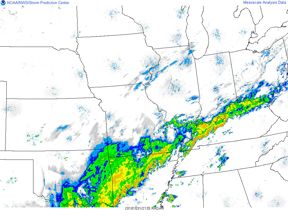
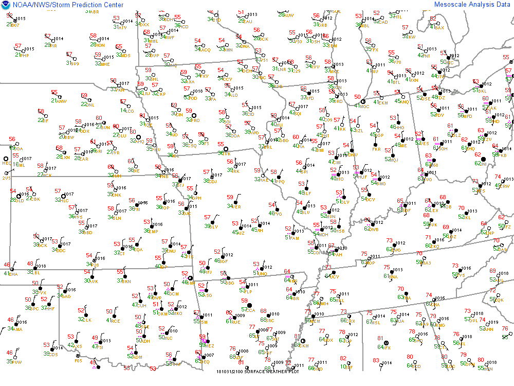
A slow-moving cold front stalled over the Ohio Valley Wednesday, Halloween. Multiple disturbances riding over the top of this system helped to bring plenty of rainfall to parts of the region as well as a brief bout of thunderstorms during Trick or Treat time.
 |
 |
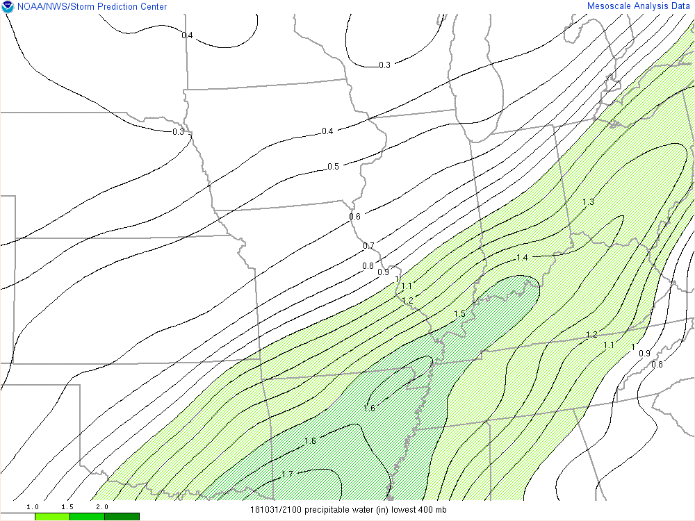 |
| Figure 1: Frontal boundary draped across the Ohio River, with plenty of moist air coming in from the southwest. | Figure 2: Surface observations showing that frontal boundary, south winds over most of KY and north winds IN/IL. | Figure 3: A measure of how much moisture is over the region, precipitable water, showing an axis of higher values over the Ohio Valley. |
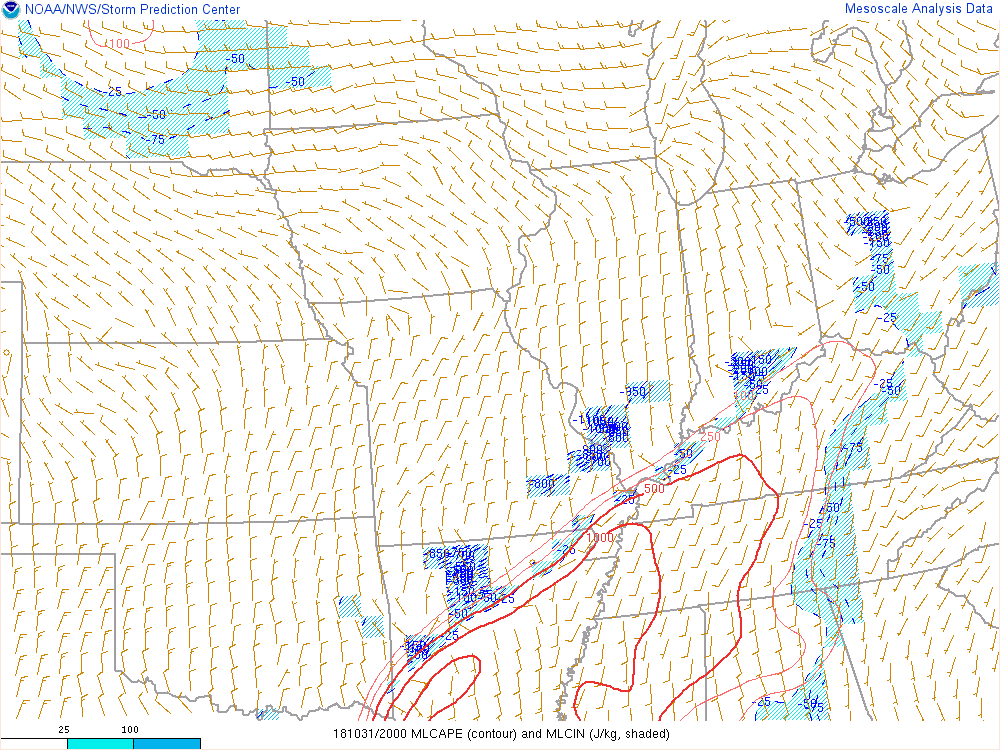
The environment was not overly primed for severe weather, but one storm was able to get organized enough to drop a quick EF-1 tornado near Rineyville as well as cause some damage downstream in Elizabethtown, Boston, and Nazareth, KY.
 |
 |
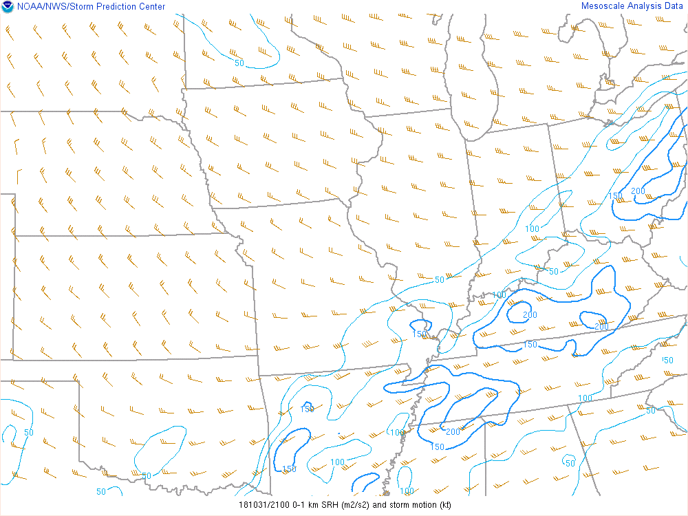 |
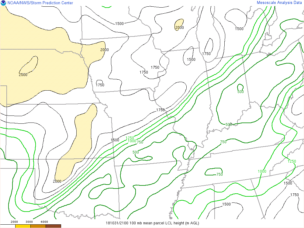
| Figure 4: Environment had some instability to work with. Area did end up with some thunderstorms. | Figure 5: Lifting Condensation Level (LCL) shows where cloud bases are lower. For high bases, tornadoes have a tough time making it to the ground. | Figure 6: Storm-relative helicity (SRH) in the layer from the surface up to 1 km above. Higher values indicate more spin in the atmosphere. |
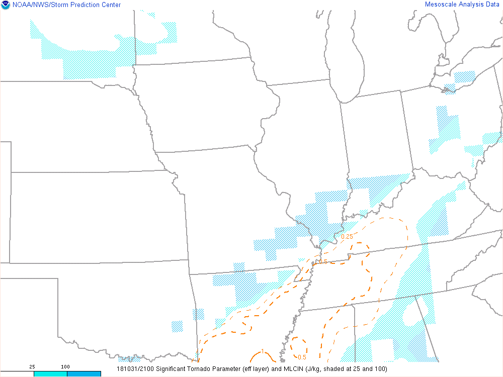 |
| Figure 7: Significant Tornado Parameter (STP), a relatively new parameter showing which areas have potential for stronger tornadoes. |
 |
Media use of NWS Web News Stories is encouraged! Please acknowledge the NWS as the source of any news information accessed from this site. |
|


 Weather Story
 Weather Map
 Local Radar