Overview
| A strong storm system moved from the Midwest into the lower Ohio Valley on April 8, 2020. Isolated storms developed during the afternoon across portions of southern Indiana and central Kentucky and dropped large hail and produced damaging winds. Later that evening, a line of severe thunderstorms moved in from the northwest and produced widespread damaging winds and small hail. An EF-1 tornado spun up along the front edge of the line of severe storms and tracked for several miles across Nelson County. Storms pushed east of the region during the early morning hours of April 9, 2020. | 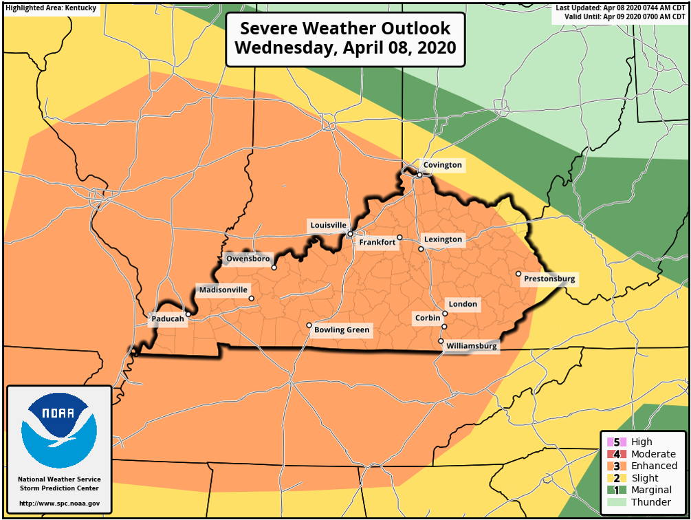 |
Tornado & Wind Damage
|
|
||||||||||
|
||||||||||
|
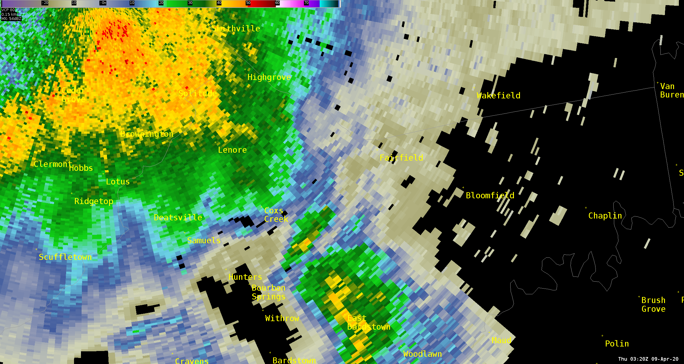
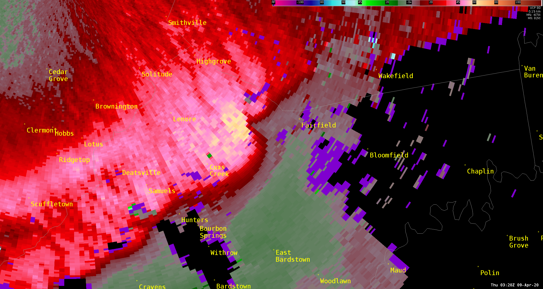
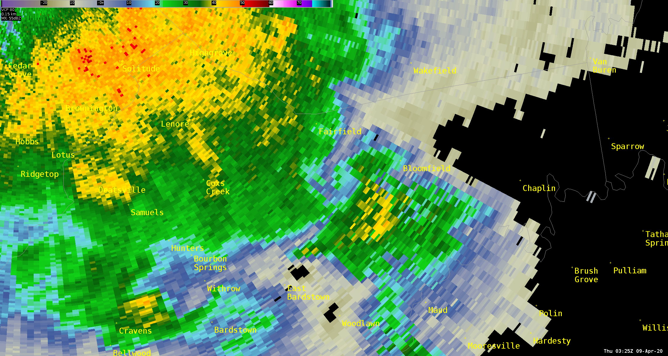
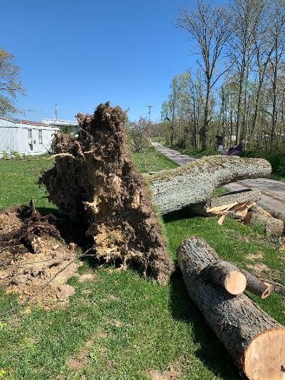
Tornado - 2 W of Fairfield, KY
Track Map 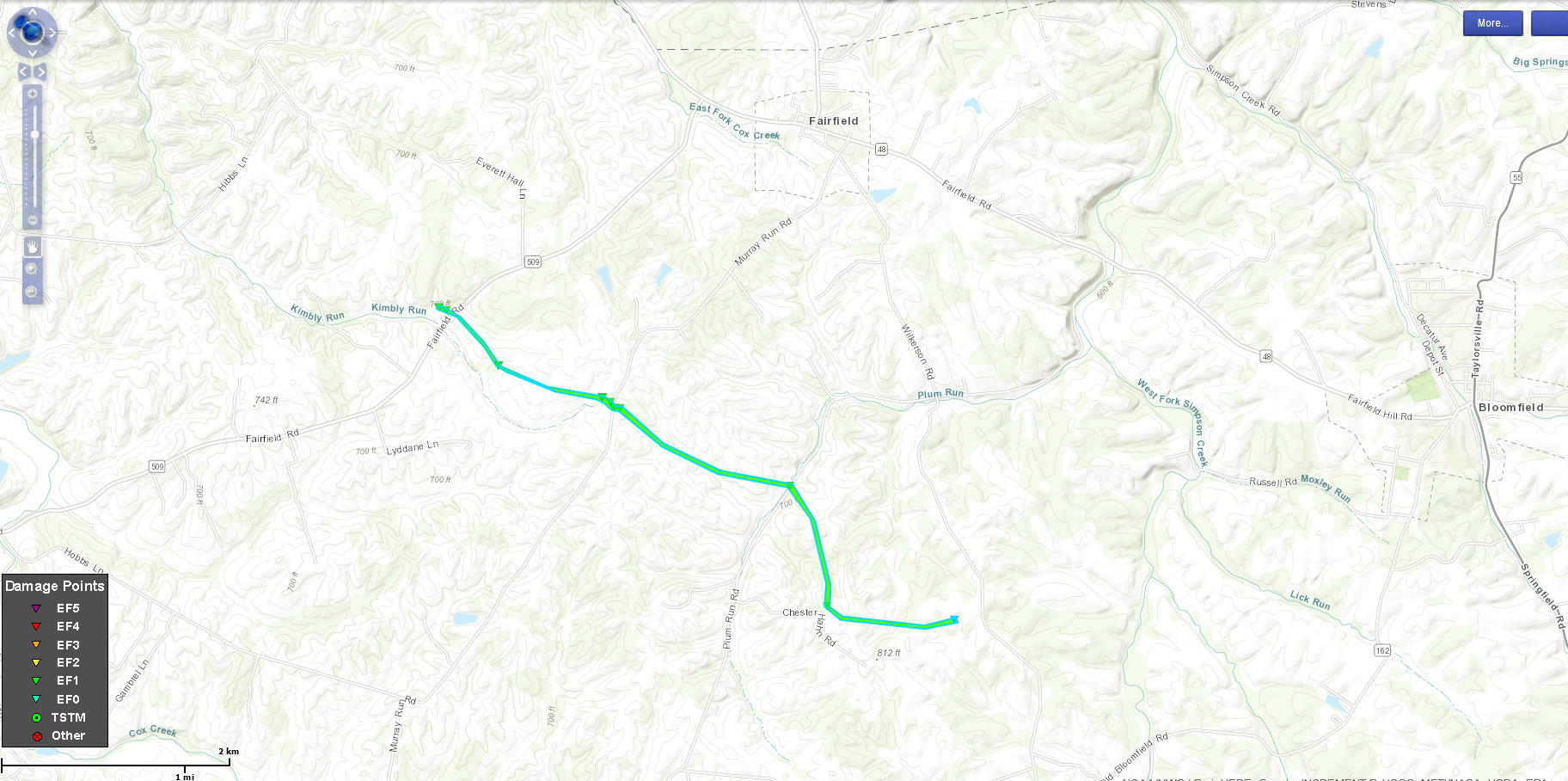 
|
||||||||||||||||
|
|
||||||||||||||||
|
Straight Line Winds -
Track Map 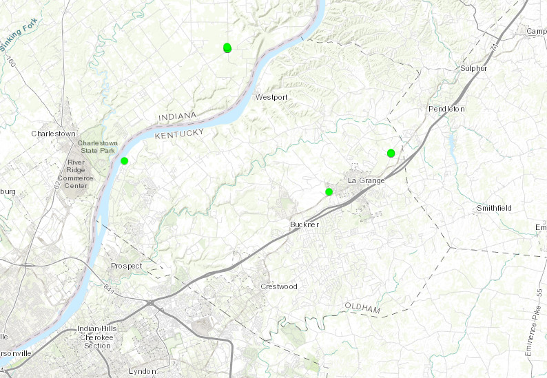
|
||||||||||||||||
|
|
||||||||||||||||
|
Straight Line Winds - Hibernia, IN
Track Map 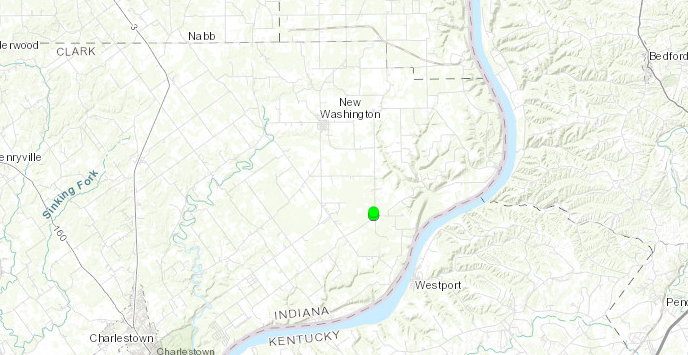
|
||||||||||||||||
|
|
||||||||||||||||
The Enhanced Fujita (EF) Scale classifies tornadoes into the following categories:
| EF0 Weak 65-85 mph |
EF1 Moderate 86-110 mph |
EF2 Significant 111-135 mph |
EF3 Severe 136-165 mph |
EF4 Extreme 166-200 mph |
EF5 Catastrophic 200+ mph |
 |
|||||
Radar
 |
 |
 |
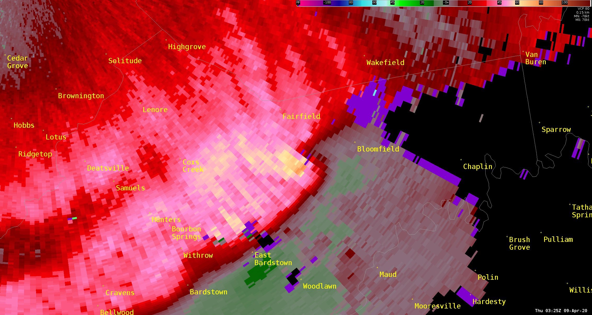 |
| Radar reflectivity (TSDF) as the tornado touched down west of Fairfield, KY. | Radar velocity (TSDF) as the tornado touched down west of Fairfield, KY. | Radar reflectivity (TSDF) as the tornado is lifting south of Fairfield, KY. | Radar velocity (TSDF) as the tornado is lifting south of Fairfield, KY. |
Storm Reports
..TIME... ...EVENT... ...CITY LOCATION... ...LAT.LON...
..DATE... ....MAG.... ..COUNTY LOCATION..ST.. ...SOURCE....
..REMARKS..
0254 PM HAIL PARIS 38.21N 84.26W
04/08/2020 E0.88 INCH BOURBON KY PUBLIC
4 SEPARATE REPORTS OF MOSTLY DIME SIZE HAIL
AROUND THE PARIS CITY LIMITS. ONE REPORT DID
SAY HAIL BRIEFLY GOT AS BIG AS NICKELS.
0257 PM HAIL 2 NE FRANKFORT 38.22N 84.83W
04/08/2020 M0.88 INCH FRANKLIN KY PUBLIC
PUBLIC REPORT OF HAIL THE SIZE OF A NICKEL.
SOCIAL MEDIA PHOTO CONFIRMS THE SIZE.
0614 PM HAIL 3 N BONNIEVILLE 37.42N 85.89W
04/08/2020 E1.75 INCH HART KY PUBLIC
0615 PM HAIL 2 S UPTON 37.43N 85.89W
04/08/2020 M1.00 INCH HART KY TRAINED SPOTTER
FORMER NWS EMPLOYEE REPORT.
0942 PM TSTM WND GST 3 N JASPER 38.43N 86.94W
04/08/2020 M52 MPH DUBOIS IN MESONET
0950 PM TSTM WND GST 2 N JOHNSBURG 38.25N 86.95W
04/08/2020 M49 MPH DUBOIS IN AWOS
AWOS STATION KHNB HUNTINGBURG.
0954 PM TSTM WND DMG 2 NNW JASPER 38.42N 86.95W
04/08/2020 DUBOIS IN EMERGENCY MNGR
POWER LINES DOWNED ON 36TH STREET.
0955 PM TSTM WND GST 3 NE MALTERSVILLE 38.38N 86.84W
04/08/2020 M59 MPH DUBOIS IN PUBLIC
WIND GUST REPORTED ALONG SR 164.
0959 PM TSTM WND GST 1 SSW FORT KNOX 37.88N 85.97W
04/08/2020 M53 MPH HARDIN KY AWOS
AWOS STATION KFTK FORT KNOX GODMAN.
1013 PM TSTM WND DMG 2 NNE MARENGO 38.39N 86.33W
04/08/2020 CRAWFORD IN TRAINED SPOTTER
REPORTS OF TREE DAMAGE AND ONE HOUSE WITH A
WINDOW BLOWN OUT ON ROSS ROAD.
1014 PM TSTM WND DMG 1 N MARTINSBURG 38.46N 86.03W
04/08/2020 WASHINGTON IN PUBLIC
TREE DOWN AND DAMAGE TO A BARN ON S BUSH
ROAD. RELAYED VIA A FORMER NWS EMPLOYEE.
1015 PM TSTM WND DMG SALEM 38.60N 86.10W
04/08/2020 WASHINGTON IN BROADCAST MEDIA
MULTIPLE REPORTS OF TREE DAMAGE AND POWER
LINES DOWN ACROSS ORANGE COUNTY.
1015 PM TSTM WND DMG MARENGO 38.37N 86.34W
04/08/2020 CRAWFORD IN EMERGENCY MNGR
SEVERAL TREES DOWN THROUGH THE COUNTY, WITH
SPECIFIC DAMAGE CENTERED AROUND MARENGO.
SEVERAL POWER OUTAGES AND LINES DOWN TOO.
1020 PM TSTM WND GST MILLTOWN 38.34N 86.27W
04/08/2020 M76 MPH HARRISON IN FIRE DEPT/RESCUE
MILLTOWN FIRE DEPARTMENT MEASURED A 76 MPH
WIND GUST.
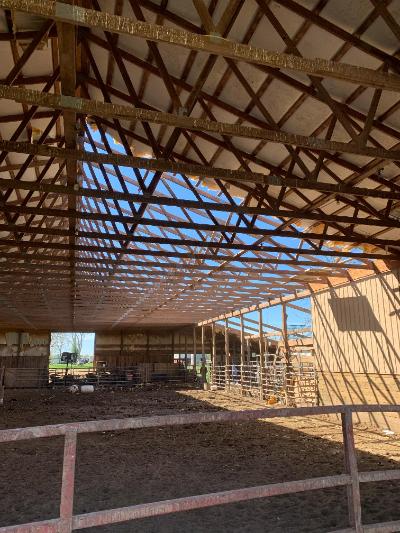
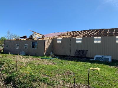
1032 PM TSTM WND DMG 1 NNW SOLON 38.52N 85.54W
04/08/2020 CLARK IN NWS STORM SURVEY
1 LARGE BARN LOST HALF OF ROOF & MULTIPLE
TREES DAMAGED NEAR HIBERNIA, IN. ESTIMATED
90 MPH STRAIGHT LINE WINDS BY NWS STORM
SURVEY.
1032 PM TSTM WND DMG 1 NNW GOSHEN 38.42N 85.60W
04/08/2020 OLDHAM KY NWS STORM SURVEY
NWS STORM SURVEY FOUND A 1/2 TO 1 MILE WIDE
SWATH OF 70-80 MPH STRAIGHT-LINE WIND DAMAGE
IN THE CARDINAL HARBOR SUBDIVISION AND TO
THE SOUTHWEST. TREE DAMAGE AS WELL AS ROOF
AND PATIO DAMAGE WAS OBSERVED.
1040 PM TSTM WND DMG GOSHEN 38.41N 85.58W
04/08/2020 OLDHAM KY BROADCAST MEDIA
SHATTERED WINDOW AND ROOF DAMAGE. MULTIPLE
TREES DOWN AS WELL.
1040 PM TSTM WND GST 1 SSE WESTPORT 38.47N 85.46W
04/08/2020 M51 MPH OLDHAM KY MESONET
KENTUCKY MESONET STATION LGRN.
1043 PM TSTM WND DMG GOLD CITY 36.75N 86.45W
04/08/2020 SIMPSON KY EMERGENCY MNGR
NO POWER IN THE GOLD CITY AND HICKORY FLATS
AREA OF SIMPSON COUNTY.
1047 PM TSTM WND GST 4 NW OKOLONA 38.18N 85.73W
04/08/2020 M54 MPH JEFFERSON KY ASOS
ASOS STATION KSDF LOUISVILLE INTL AIRPORT.
1048 PM TSTM WND DMG 3 NE LA GRANGE 38.43N 85.34W
04/08/2020 OLDHAM KY NWS STORM SURVEY
NWS STORM SURVEY FOUND STRAIGHT-LINE WINDS
OF 90 MPH CAUSED DAMAGE TO A NEW HOME UNDER
CONSTRUCTION, ROOF OF AN OUTBUILDING, AND
MULTIPLE TREES.
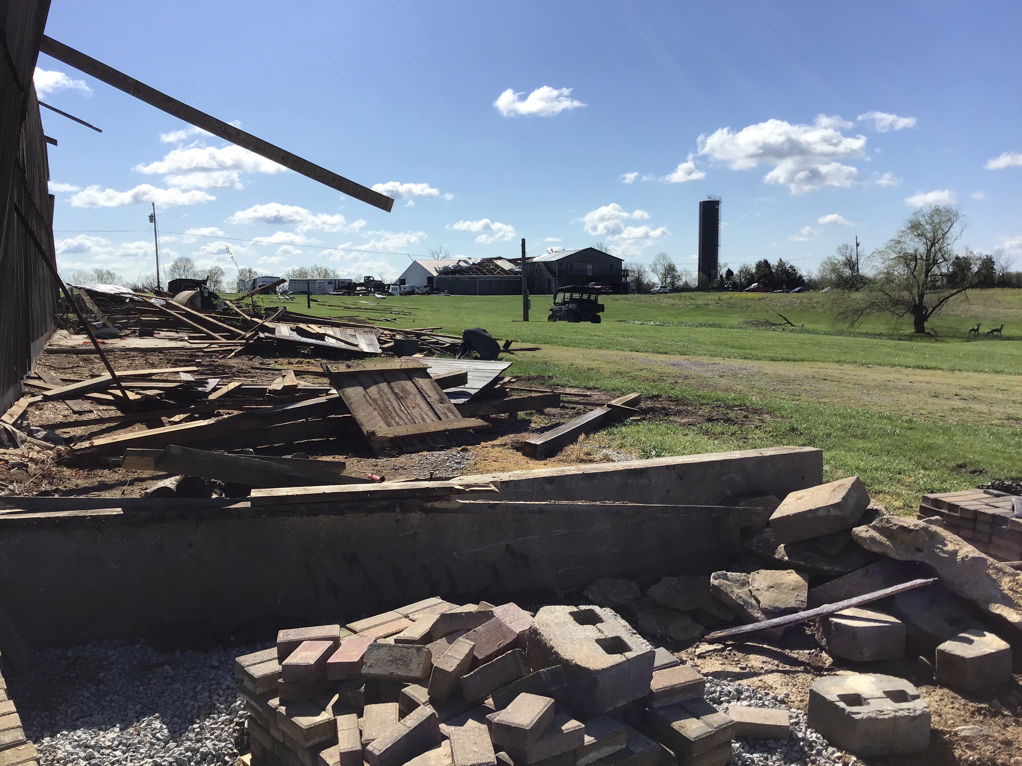
1048 PM TSTM WND DMG 1 W LA GRANGE 38.40N 85.40W
04/08/2020 OLDHAM KY NWS STORM SURVEY
NWS STORM SURVEY FOUND STRAIGHT-LINE WINDS
OF 90 MPH CAUSED DAMAGE TO A BUILDING AT THE
FAIR GROUNDS.
1050 PM TSTM WND GST 1 ESE BOWLING GREEN 36.97N 86.42W
04/08/2020 M51 MPH WARREN KY ASOS
ASOS STATION KBWG BOWLING GREEN.
1051 PM TSTM WND DMG NEW ALBANY 38.30N 85.83W
04/08/2020 FLOYD IN TRAINED SPOTTER
REPORT OF A TREE DOWN ON A HOUSE AND DECK.
1055 PM HAIL 4 NE MOOLEYVILLE 38.06N 86.43W
04/08/2020 M1.00 INCH MEADE KY AMATEUR RADIO
1100 PM TSTM WND DMG FORT KNOX 37.89N 85.96W
04/08/2020 HARDIN KY OTHER FEDERAL
REPORTS OF TREES DOWN ON CARS AND HOUSES AND
SOME DAMAGE DONE TO HANGER BUILDINGS.
1100 PM TSTM WND GST 2 S EMINENCE 38.34N 85.17W
04/08/2020 M63 MPH SHELBY KY MESONET
KENTUCKY MESONET STATION CROP.
1100 PM TSTM WND GST 1 NNW BOWLING GREEN 36.99N 86.45W
04/08/2020 M58 MPH WARREN KY MESONET
MESONET STATION 0683W 1.0 NW BOWLING GREEN
(WEATHERSTEM).
1103 PM HAIL IRVINGTON 37.88N 86.28W
04/08/2020 M0.50 INCH BRECKINRIDGE KY BROADCAST MEDIA
1120 PM TSTM WND GST 2 NNW MT. EDEN 38.08N 85.16W
04/08/2020 M53 MPH SHELBY KY MESONET
KY MESONET STATION WADD.
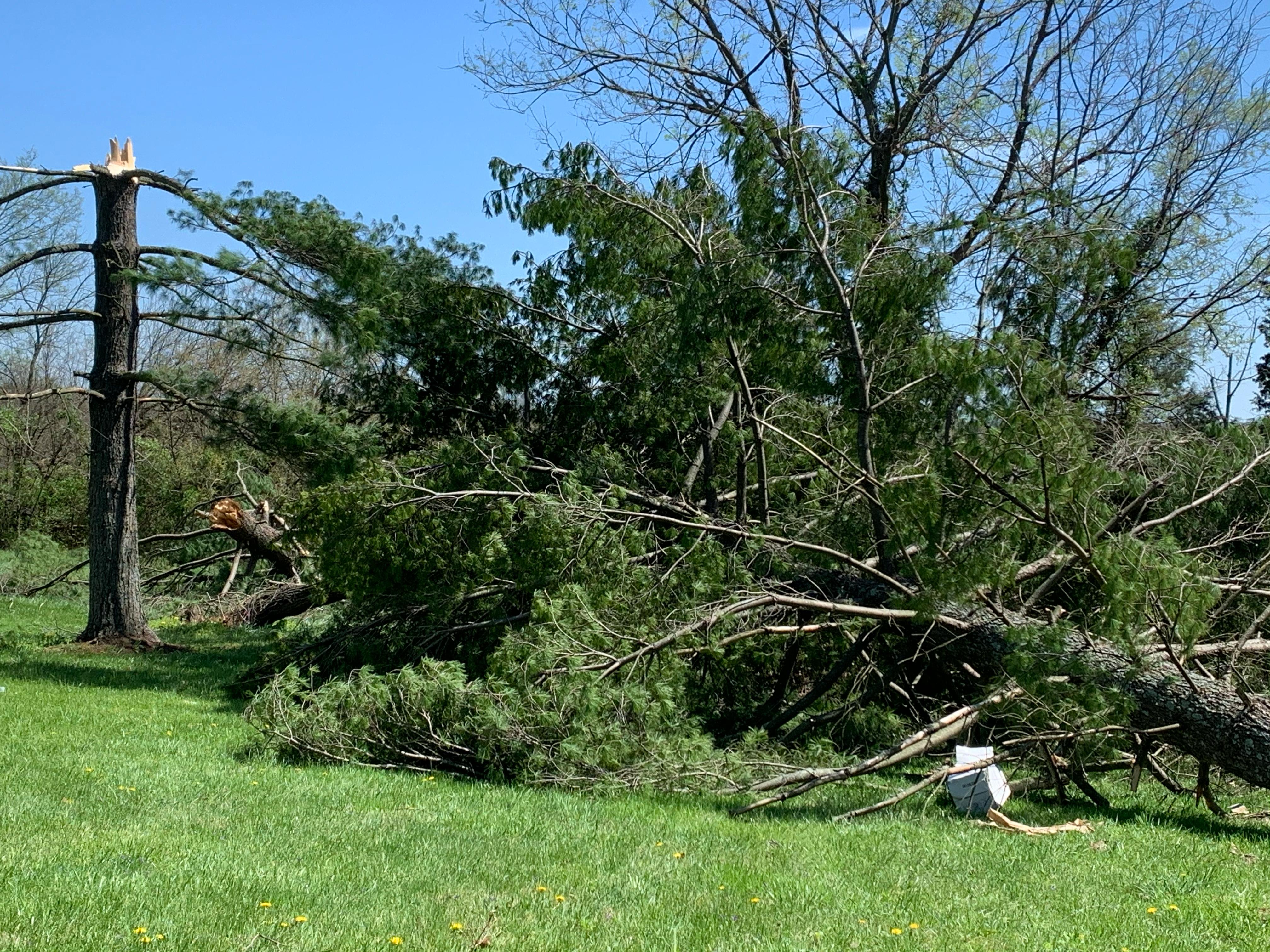
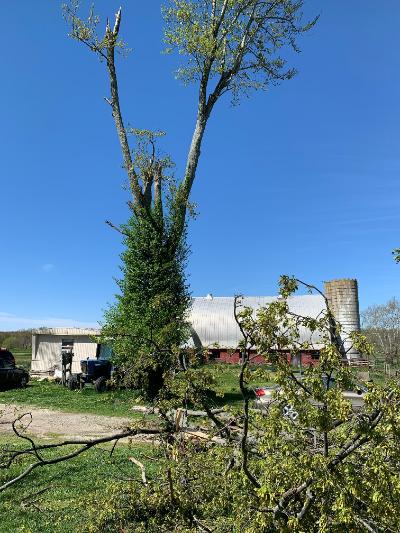
1120 PM TORNADO 2 W FAIRFIELD 37.93N 85.42W
04/08/2020 NELSON KY NWS STORM SURVEY
THE NATIONAL WEATHER SERVICE CONDUCTED A
STORM DAMAGE ASSESSMENT SURVEY ACROSS
NORTHERN NELSON COUNTY FROM STORMS LATE
WEDNESDAY NIGHT APRIL 8. THE SURVEY TEAM
FOUND WINDS BETWEEN 90 AND 95 MPH ON THE
EASTERN SIDE OF COX`S CREEK KY. THE TORNADO
INITIALLY TOUCHED DOWN ON THE NORTHWEST SIDE
OF A LARGE FAMILY HOME AND FARM ON FAIRFIELD
ROAD. THE UPPER PART OF THE ROOF OF A TWO
STORY HOME WAS LIFTED OFF AND THROWN IN
VARIOUS DIRECTIONS. SEVERAL LARGE 2 BY 10S
AND 4 BY 8S WERE IMPALED IN THE GROUND ABOUT
50 YARDS FROM THE BARN. TWO TREES ON THE
PROPERTY SUSTAINED EXTENSIVE TWISTING AND
SEVERAL LARGE SECTION OF THE TREES WERE
SNAPPED. THE TORNADO AT THIS POINT WAS ONLY
35 YARDS WIDE WITH WIND SPEEDS OF 95 MPH.
THE OWNER OF THE HOUSE WAS UPSTAIRS
SLEEPING, WHEN HE HEARD HIS EARS POPPING,
THEN A LARGE ROAR OF WIND ON TOP OF THE
HOUSE AND BRICKS FELL ON HIS BED.
SURPRISINGLY HE SUSTAINED NO INJURIES. THE
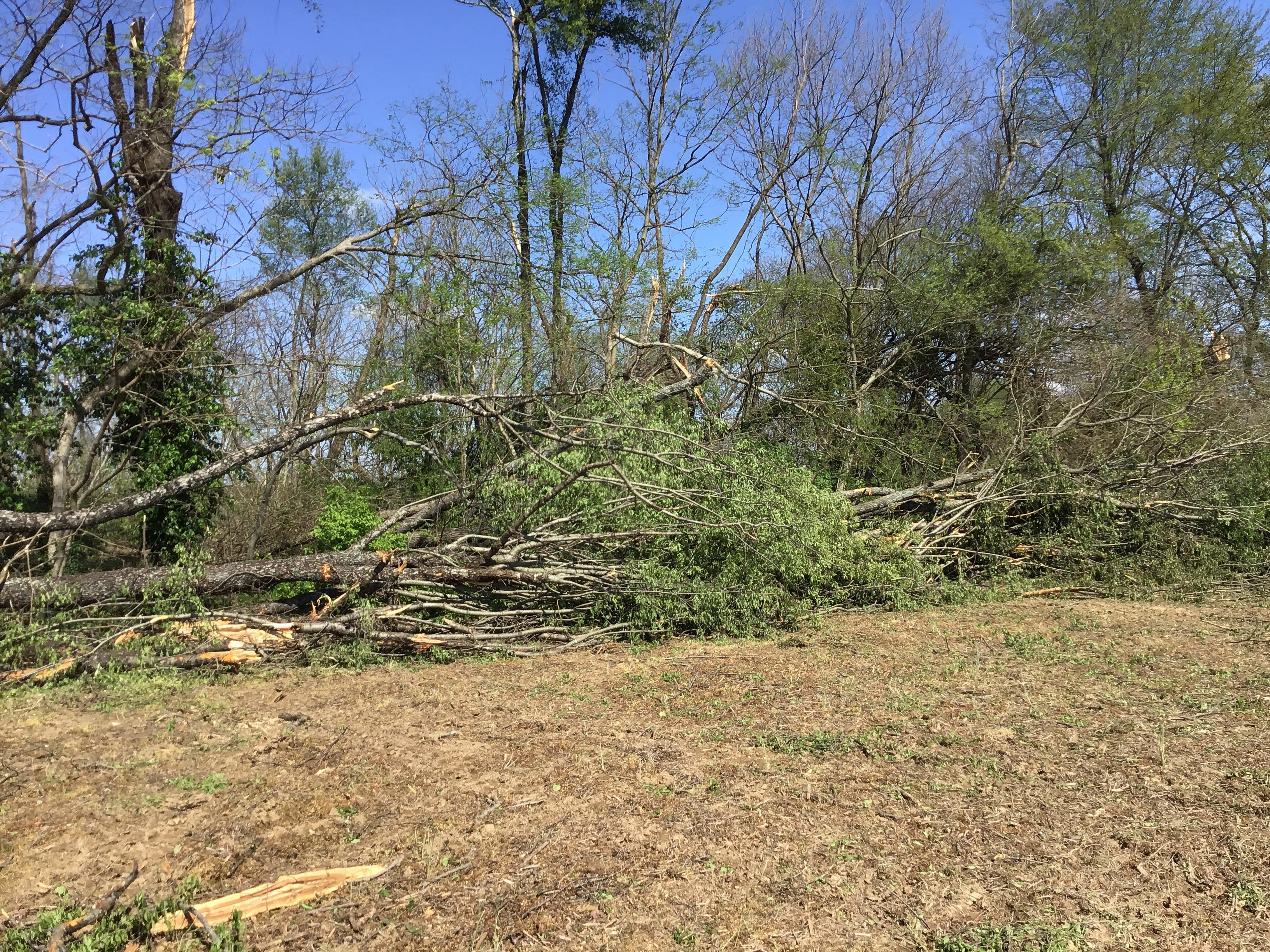
TORNADO THEN MOVED ACROSS A MIXTURE OF OPEN
FARMER FIELDS AND SCATTERED FOREST. THERE IS
A SIGNIFICANT SWATH OF TREE DAMAGE BETWEEN
FAIRFIELD ROAD AND MURRAYS RUN ROAD. TREES
WERE UPROOTED, SNAPPED, AND TWISTED. THANKS
TO NELSON COUNTY DRONE YOU COULD CLEARLY SEE
TREES LAYING IN MULTIPLE DIRECTIONS. THE
TORNADO HIT A PROPERTY ON MURRAYS RUN RD
RIPPING OFF THE SIDES OF A LARGE WELL-BUILT
BARN. THE BACK PART OF THE BARN WAS THROWN
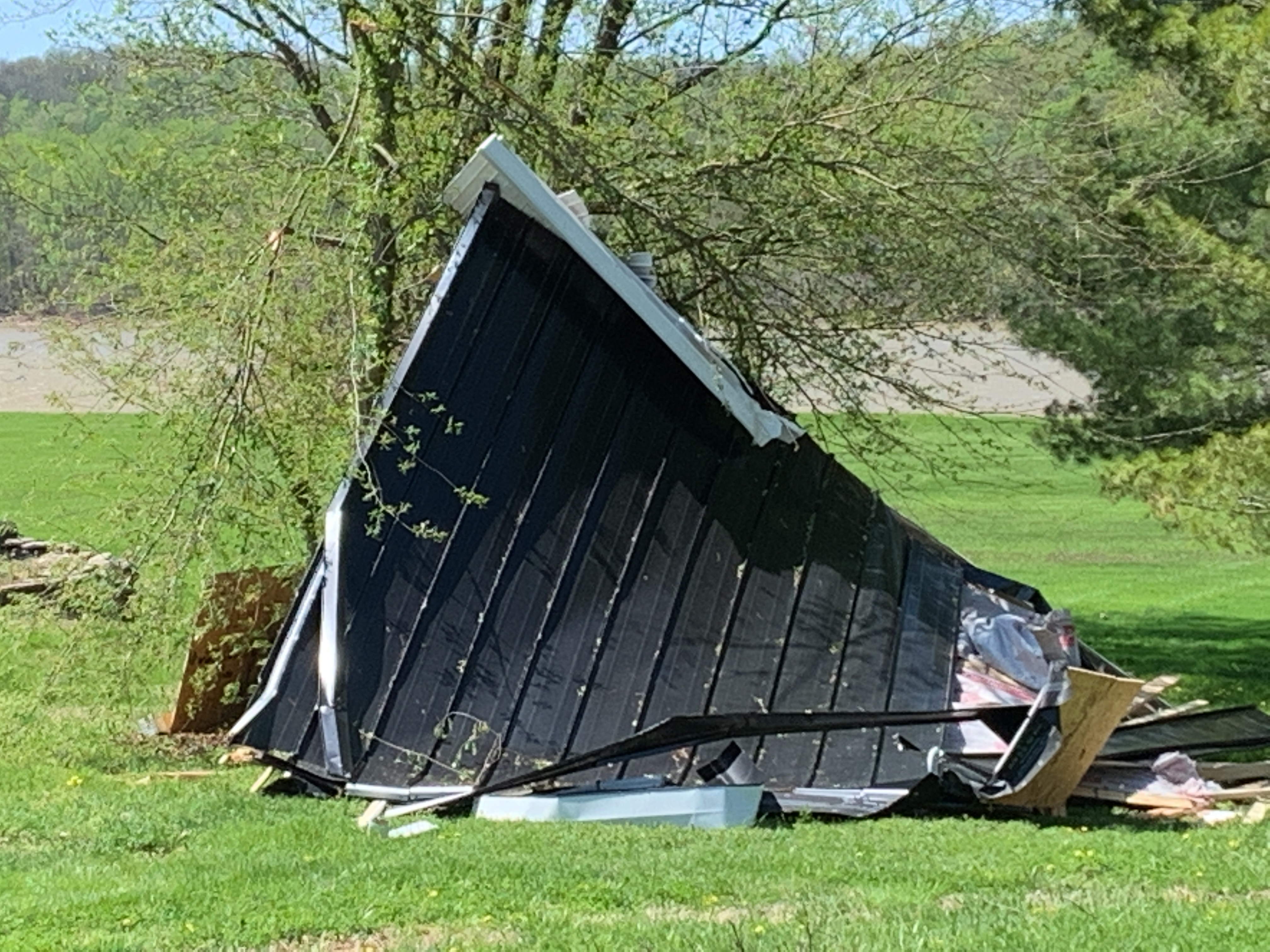
TO THE WEST WHILE A WAGON IN THE TRAILER WAS
PUSHED OUT THROUGH THE BARN. A 72 X 12 SHED,
NEXT TO THE BARN WAS DESTROYED. PARTS OF
THAT BARN WERE IMPALED INTO THE GROUND 75 TO
80 YARDS DOWN WIND. THE TORNADO WAS AT ITS
WIDEST AT 45 YARDS HERE WITH 95 MPH WINDS.
ANOTHER REMARKABLE THING IS THE FAMILY HOUSE
WAS ONLY 60 YARDS FROM THE DAMAGE PATH, AND
DID NOT EVEN HAVE A SHINGLE ON THE HOUSE.
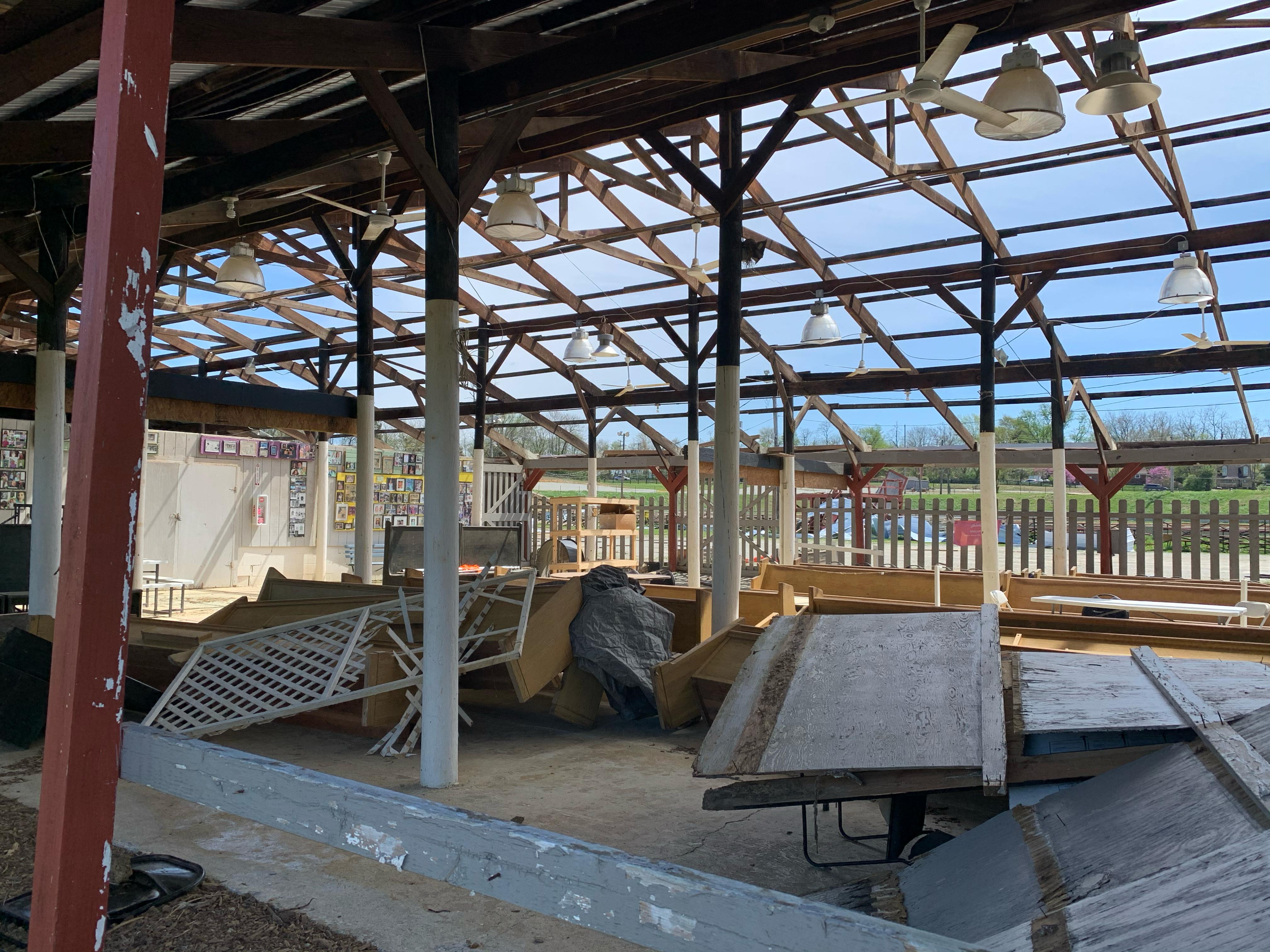
ACROSS THE STREET THE TORNADO DID EXTENSIVE
ROOF DAMAGE TO FAMILY HOUSE AND BARN,
UPLIFTING SEVERAL LARGE PARTS OF IT. DEBRIS
FROM THE BARN WAS THROWN UP TO 300 YARDS
DOWNWIND AND IN MANY DIFFERENT DIRECTIONS.
THE FAMILY SAID THAT THEY HEARD ALL THE
DOORS IN THE HOUSE SHUT TIGHTLY AND HEARD A
DISTINCT ROAR. THE TORNADO PRODUCED SPORADIC
DAMAGE ACROSS FARMLAND MAINLY IN TERMS OF
TREES, WITH MORE CONCENTRATED DAMAGE ALONG
PLUM RUN ROAD. CEDAR TREE DAMAGE WAS RATHER
EXTENSIVE WITH MANY CEDARS BEING SNAPPED AND
TWISTED. WINDS WERE AROUND 90 MPH HERE WITH
A WIDTH OF 40 YARDS. THE TORNADO DESTROYED
AN OLD BARN ON CHESTER HAHN RD BUT WEAKENED
TO AN EF0 OF 80 MPH AND ENDED WITH A FEW
SNAPPED TREES BEFORE DUGAN LANE. NWS
LOUISVILLE WOULD LIKE SEND OUT OUR SINCERE
GRATITUDE TO NELSON COUNTY DEPUTY EMERGENCY
MANAGEMENT DIRECTOR JOHN HENDRICKS FOR ALL
OF HIS ASSISTANCE.
1121 PM TSTM WND DMG 2 SW FAIRFIELD 37.91N 85.40W
04/08/2020 NELSON KY COUNTY OFFICIAL
MULTIPLE REPORTS OF TREE AND STRUCTURAL
DAMAGE ALONG MURRAYS RUN ROAD AND HIBBS LANE
IN NELSON COUNTY.
1139 PM TSTM WND DMG 3 NW WILLISBURG 37.84N 85.15W
04/08/2020 WASHINGTON KY PUBLIC
STRUCTURAL AND TREE DAMAGE ALONG BRUSH GROVE
ROAD.
1211 AM TSTM WND DMG DANVILLE 37.64N 84.77W
04/09/2020 BOYLE KY BROADCAST MEDIA
BROADCAST MEDIA RELAYED A VIDEO OF A TREE
DOWN NEAR DANVILLE. TIME ESTIMATE OFF RADAR.
1215 AM TSTM WND GST 3 WSW DANVILLE 37.62N 84.82W
04/09/2020 M49 MPH BOYLE KY MESONET
MESONET STATION DANV DANVILLE 3 SW.
1217 AM TSTM WND DMG 2 ESE MCAFEE 37.84N 84.81W
04/09/2020 MERCER KY PUBLIC
POWER OUTAGES REPORTED. WINDS ESTIMATED AT
UP TO 70 MPH.
1226 AM HAIL YOSEMITE 37.35N 84.83W
04/09/2020 M0.70 INCH CASEY KY BROADCAST MEDIA
1228 AM TSTM WND DMG 4 NE KIRKSVILLE 37.71N 84.36W
04/09/2020 MADISON KY AMATEUR RADIO
REPORT OF POWER OUTAGES IN THE WILGREEN LAKE
AREA.
1230 AM HAIL CRAB ORCHARD 37.46N 84.51W
04/09/2020 E1.00 INCH LINCOLN KY BROADCAST MEDIA
BROADCAST MEDIA RELAYED A PUBLIC PICTURE OF
QUARTER SIZED HAIL.
1236 AM HAIL BEREA 37.58N 84.29W
04/09/2020 M0.70 INCH MADISON KY AMATEUR RADIO
 |
Media use of NWS Web News Stories is encouraged! Please acknowledge the NWS as the source of any news information accessed from this site. |
|


 Weather Story
 Weather Map
 Local Radar