Overview
|
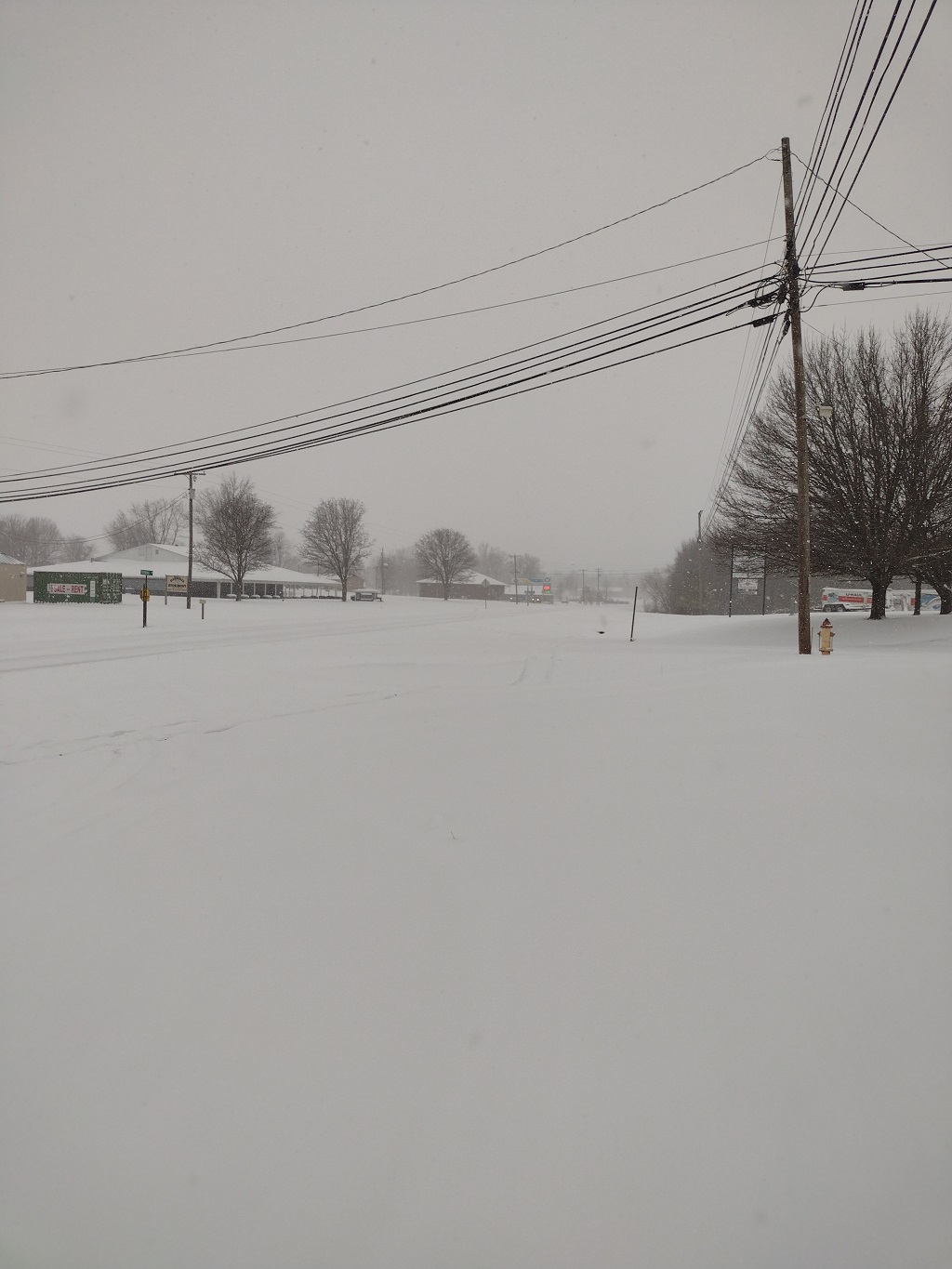
On January 6, two separate systems (1) a northern stream shortwave digging southeast into the Ohio Valley (2) a southern wave of low pressure moving along an Arctic front draped across the Southeast phased over the region and resulted in impactful snowfall across much of Kentucky. A snow band that set up along the Bluegrass Parkway resulted in reports of up to 10 inches in that area and a new daily snowfall record for January 6 was set at Lexington as well (9.9 inches). |
-SnowfallAnalysisPublic.png) Caption |
Snow Reports
...SNOWFALL REPORTS...

LOCATION                     AMOUNT    TIME/DATE       LAT/LON

...INDIANA...

...CLARK COUNTY...
1 WSW HAMBURG                2.0 IN    0914 PM 01/06   38.38N/85.78W
JEFFERSONVILLE               2.0 IN    0700 AM 01/07   38.30N/85.72W

...CRAWFORD COUNTY...
3 NNE PILOT KNOB             1.6 IN    0700 AM 01/07   38.32N/86.34W
PILOT KNOB                   1.0 IN    0624 PM 01/06   38.29N/86.35W

...DUBOIS COUNTY...
3 SSE CUZCO                  0.5 IN    0700 AM 01/07   38.44N/86.70W

...FLOYD COUNTY...
2 WNW FLOYDS KNOBS           1.5 IN    0600 AM 01/07   38.32N/85.90W

...HARRISON COUNTY...
2 NNW WHITE CLOUD            1.3 IN    0700 AM 01/07   38.26N/86.25W

...KENTUCKY...

...ALLEN COUNTY...
2 WNW MAYNARD                6.0 IN    0823 PM 01/06   36.78N/86.12W
2 WNW SCOTTSVILLE            5.8 IN    0800 AM 01/07   36.76N/86.24W
2 NW SCOTTSVILLE             5.1 IN    1100 PM 01/06   36.77N/86.22W

...ANDERSON COUNTY...
3 NNW SALVISA                6.5 IN    0651 PM 01/06   37.96N/84.89W

...BARREN COUNTY...
CAVE CITY                    4.9 IN    1045 AM 01/07   37.14N/85.96W
2 SW FINNEY                  4.0 IN    0800 AM 01/07   36.90N/86.12W

...BRECKINRIDGE COUNTY...
3 W BIG SPRING               3.3 IN    0800 AM 01/07   37.79N/86.23W

...BULLITT COUNTY...
LEBANON JUNCTION             4.0 IN    0635 PM 01/06   37.83N/85.73W
2 S BROOKS                   3.0 IN    0700 AM 01/07   38.04N/85.72W

...CASEY COUNTY...
5 SE GRAVEL SWITCH           7.0 IN    0700 AM 01/07   37.52N/85.00W
1 SE LIBERTY                 6.8 IN    0700 AM 01/07   37.30N/84.92W

...CLARK COUNTY...
WINCHESTER                   7.8 IN    1030 PM 01/06   38.00N/84.19W

...CLINTON COUNTY...
ALBANY                       7.0 IN    1134 AM 01/07   36.69N/85.14W

...CUMBERLAND COUNTY...
DUBRE                        7.5 IN    0812 PM 01/06   36.83N/85.55W
BURKESVILLE                  5.0 IN    1105 PM 01/06   36.79N/85.37W

...EDMONSON COUNTY...
BROWNSVILLE                  4.0 IN    0144 AM 01/07   37.19N/86.26W

...FAYETTE COUNTY...
6 W LEXINGTON                9.9 IN    1041 PM 01/06   38.03N/84.61W

...FRANKLIN COUNTY...
1 WNW FORKS OF ELKHORN       3.0 IN    0700 AM 01/07   38.22N/84.82W
4 N ALTON                    3.0 IN    0714 AM 01/07   38.14N/84.93W

...GARRARD COUNTY...
LANCASTER                    7.5 IN    1000 AM 01/07   37.62N/84.58W

...GRAYSON COUNTY...
2 N LEITCHFIELD              7.7 IN    1107 AM 01/07   37.51N/86.29W

...GREEN COUNTY...
GREENSBURG                   6.8 IN    1003 AM 01/07   37.26N/85.50W

...HARDIN COUNTY...
2 SE ELIZABETHTOWN           9.1 IN    0700 AM 01/07   37.69N/85.84W

...HARRISON COUNTY...
1 NE CONNERSVILLE            2.0 IN    0600 AM 01/07   38.39N/84.41W

...JEFFERSON COUNTY...
2 SSW HIGHVIEW               3.0 IN    1045 PM 01/06   38.12N/85.65W
4 E MIDDLETOWN               2.5 IN    0605 PM 01/06   38.24N/85.45W
4 NW OKOLONA                 2.3 IN    1044 PM 01/06   38.17N/85.74W
4 NW OKOLONA                 2.3 IN    1051 PM 01/06   38.17N/85.74W

...JESSAMINE COUNTY...
NICHOLASVILLE                8.5 IN    1146 AM 01/07   37.88N/84.58W
NICHOLASVILLE                8.0 IN    0624 PM 01/06   37.88N/84.58W
NICHOLASVILLE                8.0 IN    1132 AM 01/07   37.88N/84.57W

...LARUE COUNTY...
MAGNOLIA                     7.5 IN    0608 PM 01/06   37.45N/85.75W
BUFFALO                      6.0 IN    0741 PM 01/06   37.52N/85.70W

...LOGAN COUNTY...
2 NNE RUSSELLVILLE           6.1 IN    0700 AM 01/07   36.87N/86.89W
2 E EPLEYS STATION           5.2 IN    0600 AM 01/07   36.94N/86.89W

...MADISON COUNTY...
BEREA                        9.0 IN    0909 PM 01/06   37.58N/84.29W
RICHMOND                     9.0 IN    0325 PM 01/07   37.74N/84.29W
WACO                         8.5 IN    0326 PM 01/07   37.73N/84.15W
4 SSW COMBS                  8.3 IN    0700 AM 01/07   37.60N/84.14W
1 SW KINGSTON                8.0 IN    0851 PM 01/06   37.64N/84.27W

...MARION COUNTY...
LEBANON                      8.0 IN    0916 PM 01/06   37.57N/85.25W

...MEADE COUNTY...
1 NNW FLAHERTY               5.0 IN    1056 PM 01/06   37.85N/86.07W
2 S DOE VALLEY               4.0 IN    1058 PM 01/06   37.97N/86.11W

...MERCER COUNTY...
2 N HARRODSBURG              9.0 IN    0628 PM 01/06   37.79N/84.85W
2 SSE HIGH BRIDGE            9.0 IN    0700 AM 01/07   37.79N/84.71W
SALVISA                      8.3 IN    0800 PM 01/06   37.92N/84.87W

...METCALFE COUNTY...
EDMONTON                     5.3 IN    0633 PM 01/06   36.98N/85.62W

...MONROE COUNTY...
GAMALIEL                     8.1 IN    0811 PM 01/06   36.64N/85.79W

...NELSON COUNTY...
1 W BALLTOWN                 8.7 IN    0800 AM 01/07   37.73N/85.52W

...NICHOLAS COUNTY...
6 NE HOOKTOWN                2.3 IN    0750 AM 01/07   38.42N/84.07W

...OHIO COUNTY...
3 E FORDSVILLE               4.0 IN    0923 AM 01/07   37.64N/86.66W

...OLDHAM COUNTY...
2 SSW BUCKNER                1.4 IN    0700 AM 01/07   38.36N/85.45W
2 E WESTPORT                 1.0 IN    0637 PM 01/06   38.49N/85.42W

...SCOTT COUNTY...
2 N GEORGETOWN               3.3 IN    0700 AM 01/07   38.23N/84.55W
2 E NEWTOWN                  2.8 IN    0700 AM 01/07   38.22N/84.43W

...SPENCER COUNTY...
3 W ELK CREEK                2.8 IN    0700 AM 01/07   38.10N/85.42W

...TAYLOR COUNTY...
CAMPBELLSVILLE               6.0 IN    0627 PM 01/06   37.35N/85.35W

...TRIMBLE COUNTY...
4 NNW BEDFORD                0.7 IN    0700 AM 01/07   38.65N/85.36W

...WARREN COUNTY...
1 ESE BOWLING GREEN          6.3 IN    1044 PM 01/06   36.97N/86.42W
PLUM SPRINGS                 5.2 IN    0704 PM 01/06   37.02N/86.38W
3 WSW BOWLING GREEN          5.0 IN    0648 PM 01/06   36.96N/86.49W
2 NNE BOWLING GREEN          5.0 IN    0800 AM 01/07   37.00N/86.43W

...WASHINGTON COUNTY...
SPRINGFIELD                  8.0 IN    0911 PM 01/06   37.69N/85.22W

OBSERVATIONS ARE COLLECTED FROM A VARIETY OF SOURCES WITH VARYING
EQUIPMENT AND EXPOSURES. WE THANK ALL VOLUNTEER WEATHER OBSERVERS
FOR THEIR DEDICATION. NOT ALL DATA LISTED ARE CONSIDERED OFFICIAL.

$$
Photos & Video
Header
 |
 |
 |
 |
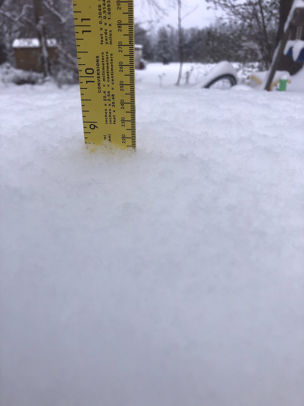
| Report of 7.5" of snow in Magnolia, KY (Jonathan Upton) |
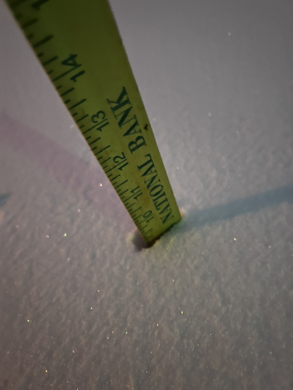
Report of 8.5" of snow at Waco,KY (Jason @firefighter6276) |
Report of 7.8" snow at Winchester, KY (@PLPhoto2015) |
North Harrodsburg 9" snow (Steven @D3viLStreams) |
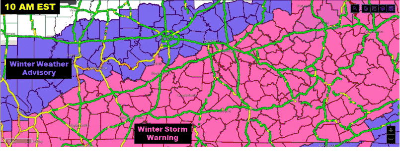
Traffic conditions from the DoT for the state of Kentucky through the day Thursday 1/6. Counties shaded in purple were under a Winter Weather Advisory, whereas counties in pink were under a Winter Storm Warning (snowfall of 4 inches or more forecast).
Radar
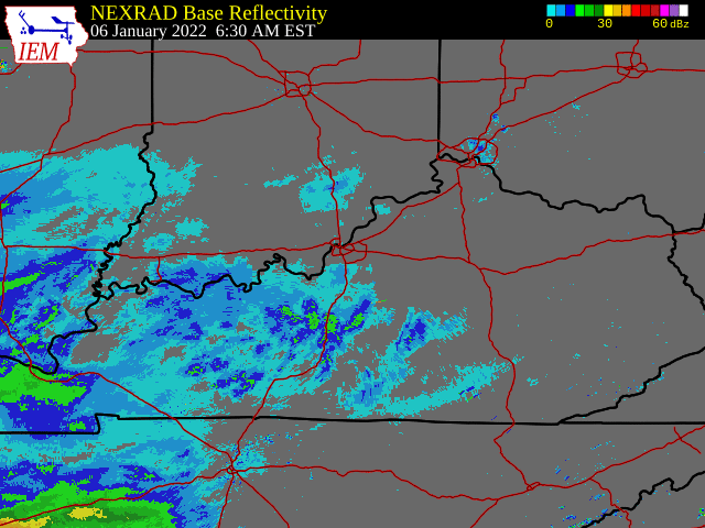
Radar loop from the event, showing the development of a band of heavy snow that impacted the Bluegrass Parkway and I-65 in the Elizabethtown vicinity and then continued to produce the very heavy snow over Lexington. That band persisted over the same area for several hours, with snow rates of 1-2 inches/hour.
 |
Media use of NWS Web News Stories is encouraged! Please acknowledge the NWS as the source of any news information accessed from this site. |
|


 Weather Story
 Weather Map
 Local Radar