Overview
|
Rounds of storms developed along a nearly stationary boundary from late morning into the afternoon on June 25th. Some minor flooding occurred with repeated rainfall, and isolated cells produced severe weather across central Kentucky. |
A home suffered significant damage just SW of Beaver Dam, KY |
 |
 |
 |
| Large trees were uprooted | Trees snapped and splintered | Scattered debris field |
Tornadoes:
|
Tornado - 3.1 Miles WSW Beaver Dam, KY
Track Map 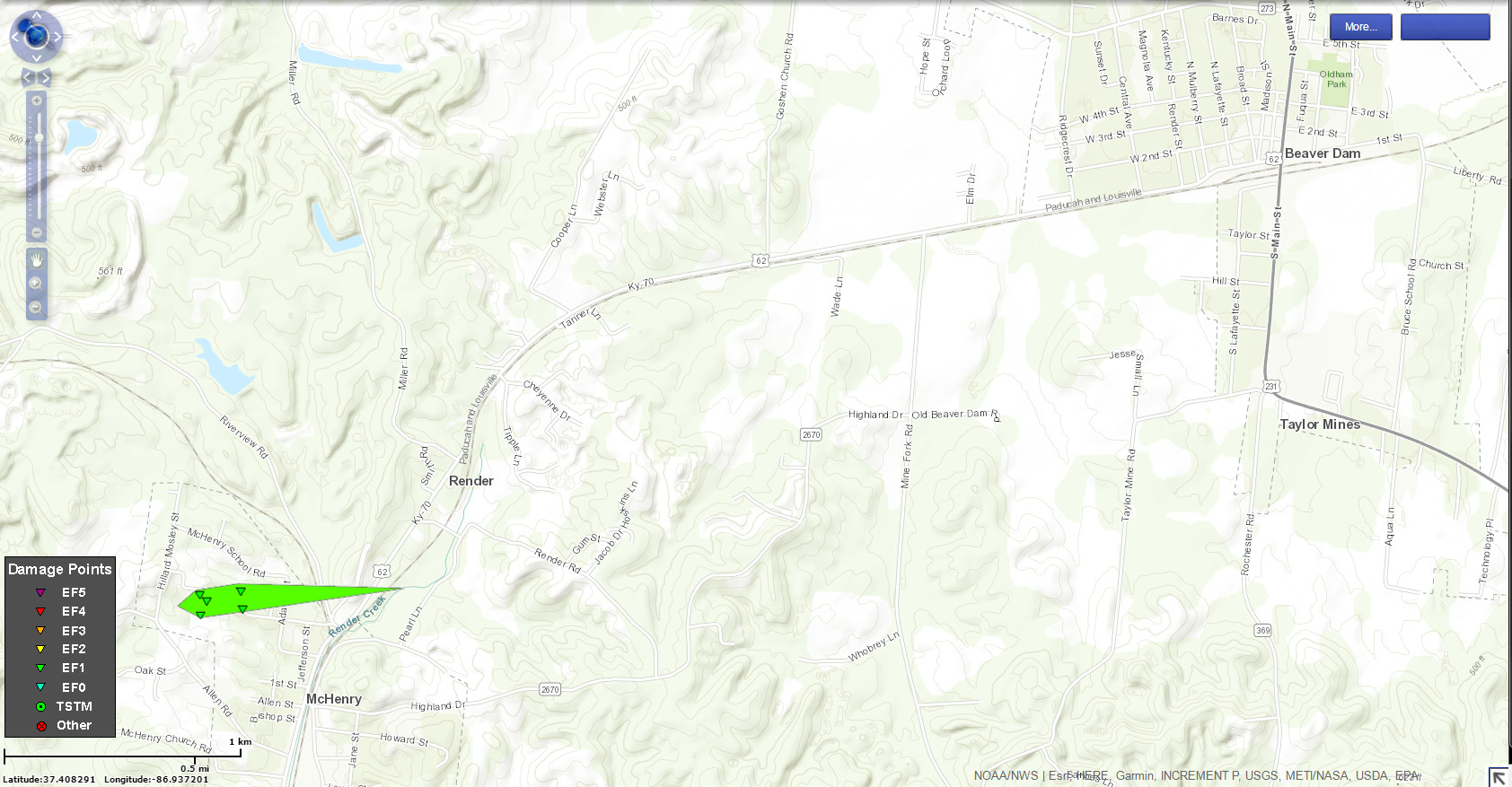 
|
||||||||||||||||||
|
Tornado - 2.3 NE of Bee Springs, KY
Track Map 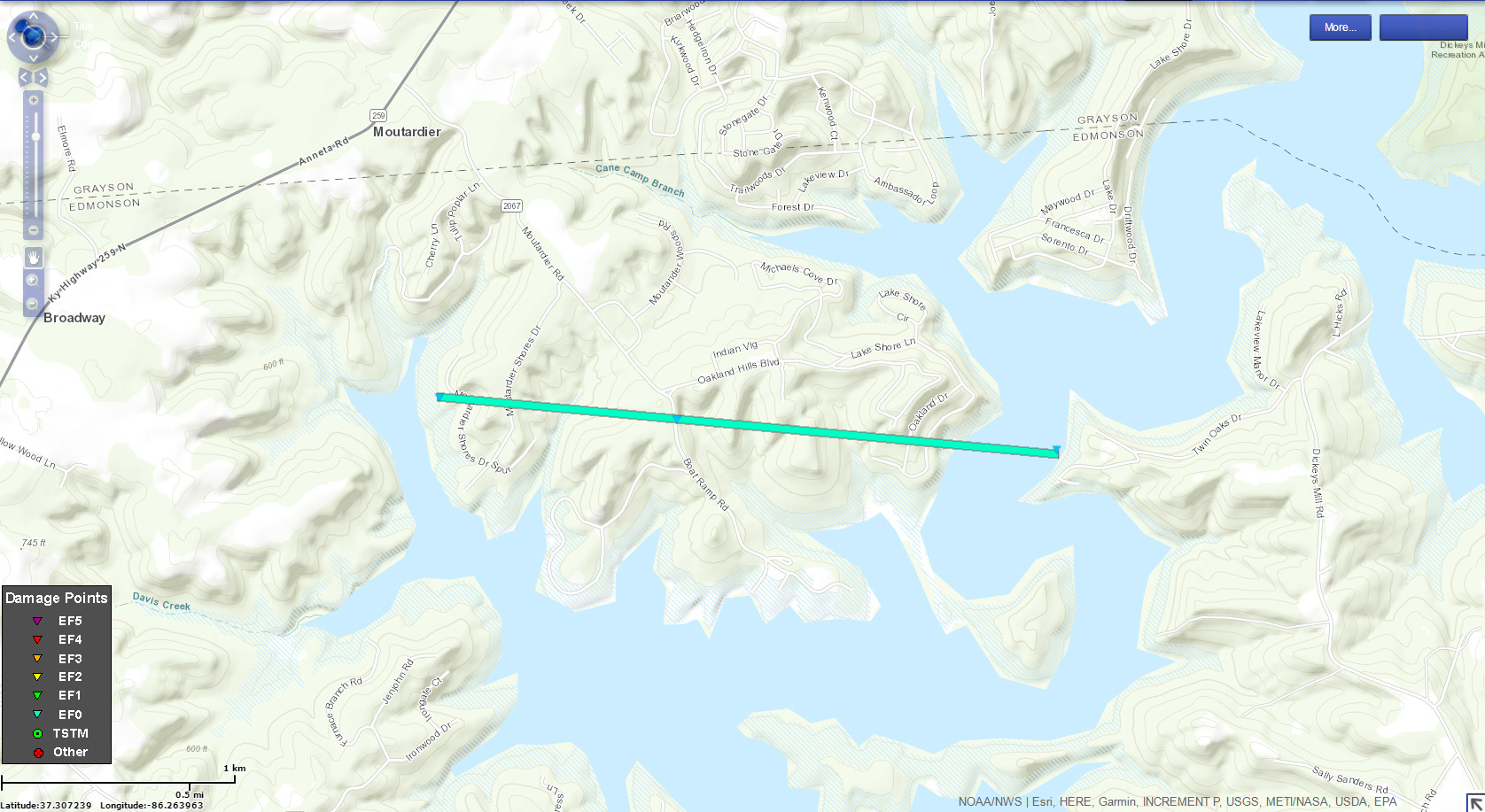
|
||||||||||||||||||
The Enhanced Fujita (EF) Scale classifies tornadoes into the following categories:
| EF0 Weak 65-85 mph |
EF1 Moderate 86-110 mph |
EF2 Significant 111-135 mph |
EF3 Severe 136-165 mph |
EF4 Extreme 166-200 mph |
EF5 Catastrophic 200+ mph |
 |
|||||
Storm Reports
PRELIMINARY LOCAL STORM REPORT...SUMMARY
NATIONAL WEATHER SERVICE LOUISVILLE KY
1147 PM EDT MON JUN 25 2018

..TIME...   ...EVENT...      ...CITY LOCATION...     ...LAT.LON...
..DATE...   ....MAG....      ..COUNTY LOCATION..ST.. ...SOURCE....
            ..REMARKS..

0210 PM     TSTM WND DMG     PIERCE                  37.18N 85.62W
06/25/2018                   GREEN              KY   EMERGENCY MNGR

            HIGHWAY 218 AND LILETOWN ROAD BLOCKED DUE TO
            DOWNED TREES.

0109 PM     TSTM WND DMG     EXIE                    37.17N 85.53W
06/25/2018                   GREEN              KY   EMERGENCY MNGR

            ELECTRIC POLE SNAPPED, TREE DOWN, AND A
            TRAMPOLINE REMOVED FROM THE PROPERTY.

1155 AM     FLOOD            2 ENE ELIZABETHTOWN     37.71N 85.84W
06/25/2018                   HARDIN             KY   LAW ENFORCEMENT

            US 62 CLOSED AT RAILROAD UNDERPASS DUE TO
            FLOODING.

1150 AM     TORNADO          1 NW MCHENRY            37.38N 86.93W
06/25/2018                   OHIO               KY   NWS STORM SURVEY

            AN EF1 TORNADO WAS ON THE GROUND FOR 0.6
            MILES ABOUT 3 MILES WSW OF BEAVER DAM.
            ESTIMATED PEAK WINDS WERE 95 TO 100 MPH IN A
            100 YARD WIDE SWATH. TWO STRUCTURES
            SUSTAINED SIGNIFICANT DAMAGE. A LARGE BRICK
            RANCH HOME HAD MOST OF THE NORTH HALF OF ITS
            ROOF TORN OFF. AT LEAST TWO DOZEN LARGE
            TREES WERE EITHER SNAPPED OR UPROOTED.

1134 AM     FLOOD            2 SE ELIZABETHTOWN      37.68N 85.85W
06/25/2018                   HARDIN             KY   PUBLIC

            WATER ON HAWKINS DRIVE NEAR I-65.
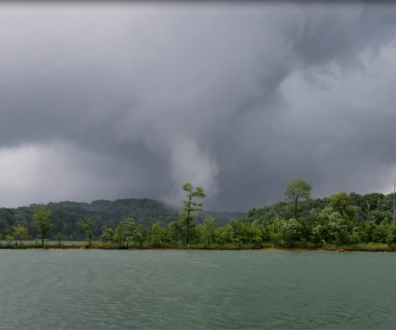
0104 PM     TORNADO          3 NE BEE SPRING         37.32N 86.25W
06/25/2018                   EDMONSON           KY   NWS STORM SURVEY

            A WEAK TORNADO SKIPPED ALONG AT MAINLY
            TREETOP LEVEL NEAR THE MOURTADIER RECREATION
            AREA. TREES WERE SNAPPED AT ITS INITIAL
            POINT NEAR SOME HOMES BEFORE IT DROPPED DOWN
            TO BECOME A WATERSPOUT ON NOLIN LAKE
            NORTHEAST OF THE MOURTADIER MARINA.
 |
Media use of NWS Web News Stories is encouraged! Please acknowledge the NWS as the source of any news information accessed from this site. |
|


 Weather Story
 Weather Map
 Local Radar