Overview
|
Numerous severe thunderstorms moved through central Kentucky and southern Indiana Sunday evening into early Monday morning March 15-16, 2026. These storms produced several instances of damaging winds as well as tornadoes across the area.
|
 EF1 Tornado Damage |
Tornadoes
Select a tornado from the table to zoom into the track and view more information. The default table view is limited to 8 tracks, but can be scrolled by a mouse wheel or dynamically expanded. Additionally, the table can fill the entire window by clicking the small circular expanding arrow icon at the very top right of the table and returned to its original size by clicking the button again. The side information panel that opens over the map can be closed using the "X" on the upper right corner of the pop-up. Zoom into the map and click damage points to see detailed information and pictures from the surveys.
|
NOTE: times shown below are local to your device's time zone. |

The Enhanced Fujita (EF) Scale classifies tornadoes into the following categories:
| EF0 Weak 65-85 mph |
EF1 Moderate 86-110 mph |
EF2 Significant 111-135 mph |
EF3 Severe 136-165 mph |
EF4 Extreme 166-200 mph |
EF5 Catastrophic 200+ mph |
 |
|||||
| Tornadoes that fail to impact any ratable damage indicators on the EF-Scale are rated EF-Unknown (EF-U) | |||||
Wind
|
Straight Line Winds - SW of Mt Washington, KY
Track Map   |
||||||||||||||
|
Straight Line Winds - Bardstown, KY
Track Map 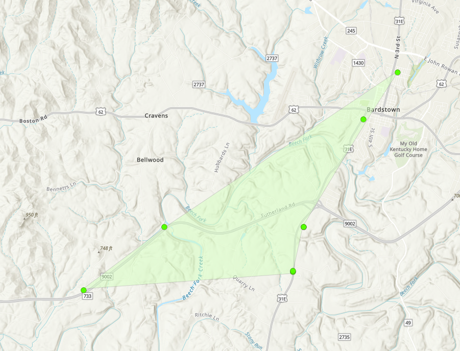 |
||||||||||||||
Radar
 |
 |
 |
 |
| KLVX Radar at 1101 PM EDT shows a lead supercell thunderstorm with a rotational velocity around 35-40 knots. This image is 2 minutes before tornado touchdown in Caneyville, KY | KLVX Radar at 1134 PM EDT shows a intense Rear Flank Downdraft (RFD) surge in western Hardin county. This signature is associated with 80-90 knot inbound velocities. Continuous damage is still occurring at this time. | KLVX Radar at 1201 AM EDT shows the end of supercell storm mode. By this time, the main squall line had caught up to the supercell, with outflow winds now surging into the Louisville Metro area, and producing sporadic wind damage throughout. | KOHX Radar at 1105 PM EDT showing a Quasi Linear Convective System (QLCS) with an an embedded mesovortice as it moves through NW Warren county. This same signature produced 3 brief tornadoes from NW Logan, southern Butler, and NW Warren counties. |
Photos & Video
Header
.jpg) |
.jpg) |
 |
 |
| A section of roof was removed from this home, and mud splatter is noted on the front of the garage door, opposite of storm motion. Tornadic winds of 100 mph were noted here. Source: NWS Damage Survey |
A large barn roof near Flaherty, KY was removed and scattered downwind. Winds at this location were estimated between 95-100 mph.
Source: NWS Damage Survey
|
2X4 boards impaled into a home just NE of Caneyville, KY. Wind speeds were estimated at 80-90 mph here.
Source: NWS Damage Survey
|
Boards from a barn roof impaled into the ground downwind from the barn, and in opposite directions.
Source: NWS Damage Survey
|
Environment
Insert synoptic summary.
 |
 |
 |
|
Figure 1: WPC Surface Analysis at 03Z on 3/16/26 A deep low pressure system moving through the lower Great Lakes drags a cold front through the Ohio Valley. Also note the tight pressure gradient, resulting in strong winds. |
Figure 2: 850mb Upper Air Plots at 03Z on 3/16/26 Deep low pressure located over IL with tight pressure gradient and thermal packing. |
Figure 3: 700 mb Upper Air Plots at 03Z on 3/16/26 Deep low pressure centered over WI with mid level moisture pooling ahead of trough axis. |
 |
 |
 |
|
Figure 4: 500 mb Upper Air Plots Deep troughing over the central US with 70 to 85 kt winds. |
Figure 5: 300 mb Upper Air Plots Deep troughing aloft over the the central US with 85kt winds digging into the base of the trough. |
Figure 6: BNA 00Z Skew T 03/16/26
|
Near-storm environment summary.
 |
 |
 |
| Figure 7: MUCAPE and Bulk Shear 03Z 3/16/26 | Figure 8: LCL and 0-1km SRH 03Z 3/16/26 | Figure 9: Significant Tornado Parameter 03Z 3/16/26 |
Additional Information
The Forecast
 |
 |
 |
 |
| SPC Day 3 Categorical Outlook | SPC Day 3 Probabilistic Outlook | SPC Day 2 Categorical Outlook | SPC Day 2 Probabilistic Wind Outlook |
 |
 |
 |
 |
| SPC Day 1 Categorical Outlook | SPC Day 1 Tornado Outlook | SPC Day 1 Wind Outlook | SPC Day 1 Hail Outlook |
Storm Reports
Preliminary Local Storm Report...Summary National Weather Service Louisville KY 1037 PM EDT Wed Mar 18 2026 ..TIME... ...EVENT... ...CITY LOCATION... ...LAT.LON... ..DATE... ....MAG.... ..COUNTY LOCATION..ST.. ...SOURCE.... ..REMARKS.. 1045 PM Tornado 1 W Lewisburg 36.99N 86.98W 03/15/2026 Logan KY NWS Storm Survey NWS STORM DAMAGE SURVEY DETERMINED THAT AN EF0 TORNADO TOUCHED DOWN 1 S JERICO IN LOGAN COUNTY, KY AT APPROXIMATELY 10:45 PM EDT ON SUNDAY MARCH 15, 2026. THE TORNADO TRAVELLED NE FOR A TOTAL PATH LENGTH OF 0.78 MILES WITH A WIDTH OF 40 YARDS, ENDING 1 SE OF JERICO IN BUTLER COUNTY, KY. SEE ASSOCIATED PNS FOR MORE DETAILS. 1103 PM Tornado 1 E Millwood 37.45N 86.48W 03/15/2026 Grayson KY NWS Storm Survey Beginning point for tornado that tracked through Grayson Meade and Hardin counties. Refer to public information statement issued by the office for more details on this tornado. 1106 PM Tornado 2 SW Riverside 37.15N 86.58W 03/15/2026 Warren KY NWS Storm Survey The National Weather Service conducted a storm survey on Wednesday, March 18th for the storms that occurred on Sunday night, March 15th. A tornado was determined to have occurred in Warren County with max winds of 90 MPH (EF1). Damage was first observed along Pisgah Ridge near White Road south of Richardson Road. A nearby residence had minor shingle damage, but several farm outbuildings had significant roof damage. While most of the damage had a northeast direction with the storm motion, there was evidence of rotation. One barn roof was lofted to the northeast, however there were wood planks that were impaled into the ground in the opposite direction to the southwest. Also, a nearby shed was leaning to the northwest, which was toward the tornado circulation path. The tornado continued uphill toward more farm outbuildings where a roof was lofted to the north and to the east, which was slightly offset from the northeast storm motion and evidence of rotation. Max wind speeds in this location were estimated to be 90 mph. The damage continued to the northeast along James Elkins Road where several trees had snapped damage. The nearby barn had roofing material loss, and the building was shifted and leaning to the northeast after being hit by the tornado. The roof damage was laying in several different directions and the snapped tree damage had evidence of breaking and twisting with the passing of the tornado. The tornado continued across Hall Road and toward Karl Young Road where damage to a home and nearby outbuildings occurred. The homeowner mentioned that the tornado had picked up a zero turn mower and placed it back down on top of the shed roof damage. A nearby barn was destroyed as well. Debris was lofted into a nearby field to the north and northeast of the location. Several wood plank and plywood impalements were noted facing north and west, which was continued evidence of rotation. Beyond the field north of Karl Young Road, no additional damage was observed. 1119 PM Tornado 4 SSE Hudson 37.60N 86.27W 03/15/2026 Hardin KY NWS Storm Survey Point where long track tornado first entered Hardin County. Refer to public information statement issued by the office for more details on this tornado. 1136 PM Tornado 1 SE Flaherty 37.82N 86.05W 03/15/2026 Meade KY NWS Storm Survey Point where long track tornado moved into Meade County. Refer to public information statement issued by the office for more details on this tornado. 1144 PM Tornado 1 SW Fort Knox 37.88N 85.98W 03/15/2026 Hardin KY NWS Storm Survey Point where long track tornado entered Hardin County a second time. Refer to public information statement issued by the office for more details on this tornado. 0135 AM Tornado 2 SW Albany 36.66N 85.16W 03/16/2026 Clinton KY NWS Storm Survey An NWS storm survey found that a brief EF-1 tornado touched down early on the morning of March 16th. The tornado had a peak wind of 100 mph with a path length of 1.26 miles. The maximum width was 200 yards. Just east of Highway 738 toward Albany, minor damage to homes occurred, along with damaged or destroyed barns and outbuildings. 1130 AM Tstm Wnd Dmg Vertrees 37.70N 86.14W 03/15/2026 Hardin KY Fire Dept/Rescue Multiple power poles down on KY86 near Vertrees Church Lane. 1030 PM Tstm Wnd Dmg 2 S Huntingburg 38.28N 86.96W 03/15/2026 Dubois IN Fire Dept/Rescue Power pole and tree down and on fire in the 1100 block of Ridgewood Dr. Time estimated from radar. 1043 PM Tstm Wnd Dmg 2 SSW Kyana 38.27N 86.79W 03/15/2026 Dubois IN 911 Call Center Tree blocking both lanes in the 7800 block of S 600 E. Time estimated from radar. 1045 PM Tstm Wnd Dmg 2 SSE Cuzco 38.46N 86.70W 03/15/2026 Dubois IN Trained Spotter Several trees blown down and a roof on a small livestock shed came off. Time estimated from radar. 1045 PM Tstm Wnd Dmg 3 ENE Celestine 38.41N 86.73W 03/15/2026 Dubois IN 911 Call Center Tree in the roadway. E Ellsworth and N 900 E. Time estimated from radar. Another large tree 2 feet in diameter blocking both lanes in the 7800 block of E State Road 164. 1106 PM Tstm Wnd Dmg 1 WSW Riverside 37.16N 86.57W 03/15/2026 Warren KY Emergency Mngr Damage to car port. 1106 PM Tstm Wnd Dmg 2 WSW Riverside 37.15N 86.58W 03/15/2026 Warren KY Emergency Mngr Damage to barns. 1111 PM Tstm Wnd Dmg 1 SSE Welchs Creek 37.34N 86.55W 03/15/2026 Butler KY 911 Call Center Large tree down on the 900 block of Grancer Road. 1122 PM Tstm Wnd Dmg 4 SE Hudson 37.60N 86.24W 03/15/2026 Hardin KY Broadcast Media Reports of numerous trees down along Hwy 84 near Hardin Springs. Time estimated from radar. 1125 PM Tstm Wnd Dmg Leitchfield 37.48N 86.29W 03/15/2026 Grayson KY Emergency Mngr Corrects previous tstm wnd dmg report from Leitchfield. 30 trees down calls in Leitchfield and about 4300 customers without power in Grayson County. 1127 PM Tstm Wnd Dmg 1 NE Custer 37.74N 86.24W 03/15/2026 Breckinridge KY 911 Call Center Few trees down on 86 but roadway is passable. Powerlines down on Vertress near Consstintine Rd. Time estimated from radar. 1128 PM Tstm Wnd Dmg 3 ESE Constantine 37.65N 86.21W 03/15/2026 Hardin KY Amateur Radio Roof off of a home on Pierce Mill Road. 1129 PM Tstm Wnd Dmg Kossuth 38.70N 86.10W 03/15/2026 Washington IN Emergency Mngr Power lines were down on Kossuth Road. 1130 PM Tstm Wnd Dmg Vertrees 37.70N 86.13W 03/15/2026 Hardin KY Fire Dept/Rescue Corrects time on previous storm report from Vertrees. Multiple power poles down on KY86 near Vertrees Church Lane. 1130 PM Tstm Wnd Dmg Salem 38.61N 86.10W 03/15/2026 Washington IN Emergency Mngr Power lines came down on Water Street in Salem. 1135 PM Tstm Wnd Dmg Howe Valley 37.69N 86.09W 03/15/2026 Hardin KY Amateur Radio Tree down across the 8500 block of KY86 in Howe Valley. 1137 PM Tstm Wnd Dmg 1 E Millerstown 37.44N 86.04W 03/15/2026 Hart KY Emergency Mngr Several trees downed and power lines downed along Raider Hollow Road in Millerstown. Time estimated from radar. 1140 PM Tstm Wnd Dmg Flaherty 37.84N 86.07W 03/15/2026 Meade KY Emergency Mngr Reports of multiple trees down. 1140 PM Tstm Wnd Dmg 2 W Rineyville 37.74N 86.01W 03/15/2026 Hardin KY NWS Employee 6200 block of Rineyville-Big Springs Road. House suffered roof damage with shingles and decking peeled back. Time based on radar data. 1140 PM Tstm Wnd Dmg 1 ESE Flaherty 37.83N 86.05W 03/15/2026 Meade KY Emergency Mngr Bank sign damaged. 1141 PM Tstm Wnd Dmg 1 W Cecilia 37.67N 85.97W 03/15/2026 Hardin KY Trained Spotter Power poles down on KY 86 in Cecilia. 1141 PM Tstm Wnd Dmg 3 E Flaherty 37.84N 86.02W 03/15/2026 Meade KY Emergency Mngr Multiple buildings severely damaged, power lines down and trees in the roadway. 1141 PM Tstm Wnd Dmg 2 E Flaherty 37.83N 86.02W 03/15/2026 Meade KY Emergency Mngr Large tree on house. 1142 PM Tstm Wnd Dmg 2 NE Cecilia 37.69N 85.93W 03/15/2026 Hardin KY Public Railroad crossing gate broken off hinges on Hayden School Road. 1143 PM Tstm Wnd Dmg 3 ENE Flaherty 37.86N 86.01W 03/15/2026 Meade KY Emergency Mngr Power lines across the roadway, damage to multiple barns. 1150 PM Tstm Wnd Dmg 2 WNW Bowling Green 36.99N 86.47W 03/15/2026 Warren KY 911 Call Center Tree down blocking Holly Drive near Dennis Way. 1151 PM Tstm Wnd Dmg 2 W Greenville 38.37N 86.01W 03/15/2026 Floyd IN Emergency Mngr Tree down blocking Kiesler Rd. 1152 PM Tstm Wnd Dmg 1 SSW Scottsburg 38.67N 85.79W 03/15/2026 Scott IN Broadcast Media The Scottsburg Water Department had its roof peeled back on the 700 block of West Lake Road West. 1152 PM Tstm Wnd Dmg 1 WNW Lebanon Junction 37.84N 85.74W 03/15/2026 Bullitt KY Emergency Mngr Multiple trees down in Lebanon Junction. One tree was blown down onto a vehicle. 1200 AM Tstm Wnd Dmg 2 W Cementville 38.35N 85.78W 03/16/2026 Floyd IN Emergency Mngr Semi flipped over blocking the west bound I-265 at mile 33.6. Time estimated from radar. 1201 AM Tstm Wnd Dmg 4 SW Mount Washington 38.00N 85.60W 03/16/2026 Bullitt KY Emergency Mngr Multiple trees and power lines down along Ridge Road east of Shepherdsville. 1204 AM Tstm Wnd Dmg 3 SW Mount Washington 38.01N 85.59W 03/16/2026 Bullitt KY Public Several trees down alongside roof and siding damage. Small shed also damaged. All damage located along Mockingbird Ct in Mt Washington, KY. 1204 AM Tstm Wnd Dmg 3 SW Mount Washington 38.02N 85.58W 03/16/2026 Bullitt KY Emergency Mngr Multiple structures damaged along Armstrong Lane in Mount Washington as well as tree and power line damage. 1204 AM Tstm Wnd Dmg 3 SW Mount Washington 38.01N 85.59W 03/16/2026 Bullitt KY Public Several trees down alongside roof and siding damage. Small shed also damaged. All damage located along Mockingbird Ct in Mt Washington, KY. 1204 AM Tstm Wnd Dmg 3 SW Mount Washington 38.02N 85.58W 03/16/2026 Bullitt KY Emergency Mngr Multiple structures damaged along Armstrong Lane in Mount Washington as well as tree and power line damage. 1205 AM Tstm Wnd Dmg 1 N Bardstown 37.82N 85.46W 03/16/2026 Nelson KY Public Trees down along West Halstead Ave and West Forrest Ave. 1205 AM Tstm Wnd Dmg Bardstown 37.82N 85.46W 03/16/2026 Nelson KY Public Trees down on East Halstead Ave and Moore Ave as well as East Forrest Ave. 1208 AM Tstm Wnd Dmg 2 S Memphis 38.46N 85.77W 03/16/2026 Clark IN Emergency Mngr Tree Down in Road N US 31 & Killen Rd Memphis. 1208 AM Tstm Wnd Dmg Hillview 38.07N 85.69W 03/16/2026 Bullitt KY Public Tree down on Blossom Rd. 1210 AM Tstm Wnd Dmg 2 E Jeffersonville 38.31N 85.69W 03/16/2026 Clark IN Emergency Mngr Power line down. 1215 AM Tstm Wnd Dmg 1 WNW Cementville 38.36N 85.77W 03/16/2026 Clark IN Public Tree down in Rd - Payne Koehler/County Line Road. 1217 AM Tstm Wnd Dmg 2 N Memphis 38.51N 85.77W 03/16/2026 Clark IN Public 16.4 Mile marker S I-65 Tree down in road. 1218 AM Tstm Wnd Dmg Memphis 38.49N 85.76W 03/16/2026 Clark IN Public Report of tree down on US 31. 1221 AM Tstm Wnd Dmg 2 NE Hanover 38.74N 85.45W 03/16/2026 Jefferson IN Emergency Mngr Couple of trees down State Rd 256 and State Rd 56. 1230 AM Tstm Wnd Dmg 1 E Cementville 38.35N 85.73W 03/16/2026 Clark IN Emergency Mngr Semi flipped over on WB I-265 blocking. 1233 AM Tstm Wnd Dmg 1 WSW Glasgow 36.99N 85.94W 03/16/2026 Barren KY 911 Call Center Tree down blocking entire road just off intersection of Forrester and Cleveland. 1255 AM Tstm Wnd Dmg 2 WNW Gascon 37.01N 85.60W 03/16/2026 Metcalfe KY 911 Call Center Tree down in the road at Boston and Greensburg Rd. Another tree reported down at Columbia and Mosby Ridge. Time estimated from radar. 0100 AM Tstm Wnd Dmg 3 N Gascon 37.04N 85.56W 03/16/2026 Metcalfe KY 911 Call Center Tree down on the 2400 block of Bridgeport Road. 0105 AM Tstm Wnd Dmg 2 SSW Gradyville 37.06N 85.43W 03/16/2026 Adair KY 911 Call Center Tree down blocking Cumberland Parkway westbound. 0106 AM Tstm Wnd Dmg 3 WNW Georgetown 38.22N 84.61W 03/16/2026 Scott KY 911 Call Center Multiple trees down on Stamping Ground Road near Betsy Way. 0107 AM Tstm Wnd Dmg 3 WSW Oxford 38.25N 84.58W 03/16/2026 Scott KY 911 Call Center Tree down on the 1000 block of McClelland Circle. 0114 AM Tstm Wnd Dmg 3 NNW Glens Fork 37.05N 85.27W 03/16/2026 Adair KY 911 Call Center Tree down blocking the roadway at 4710 Highway 55 S. 0125 AM Tstm Wnd Dmg 2 NNE Peytonsburg 36.66N 85.37W 03/16/2026 Cumberland KY Emergency Mngr Old building destroyed along 3108 headed towards Salvation Army Camp. No other damage there. Also have a nearby tree down at Sulphur Creek Road near Mikes Landing. Time estimated from radar. 0135 AM Tstm Wnd Dmg 2 SSW Albany 36.66N 85.16W 03/16/2026 Clinton KY Emergency Mngr Report widespread tree damage in county. Concentrated area of damage along Rice Land and 738 as well as Robert Page Road. Power poles leaning. Had some outdoor structures damaged. Time estimated from radar. 0145 AM Tstm Wnd Dmg 2 ENE Hustonville 37.48N 84.78W 03/16/2026 Lincoln KY Public Wind caused roof siding to rip off on a home 2 miles away from Hwy 127 near Hustonville. Not given cardinal direction away from Hwy...so estimated location and time. 1050 PM Tstm Wnd Gst 1 NNW Bowling Green 36.99N 86.45W 03/15/2026 M56 MPH Warren KY Mesonet Mesonet station 0683W 1.0 NW Bowling Green (WEATHERSTEM). 1056 PM Tstm Wnd Gst 2 N Johnsburg 38.25N 86.95W 03/15/2026 M51 MPH Dubois IN AWOS AWOS station KHNB Huntingburg. 1105 PM Tstm Wnd Gst 2 WSW Woodbury 37.16N 86.67W 03/15/2026 M68 MPH Butler KY Mesonet 1118 PM Tstm Wnd Gst Leitchfield 37.48N 86.30W 03/15/2026 M64 MPH Grayson KY Mesonet Mesonet station AV189 Leitchfield. 1125 PM Tstm Wnd Gst 3 WSW Leitchfield 37.46N 86.34W 03/15/2026 M62 MPH Grayson KY Mesonet Mesonet station BLRK Leitchfield 3 W. 1132 PM Tstm Wnd Gst Howe Valley 37.69N 86.09W 03/15/2026 M60 MPH Hardin KY Fire Dept/Rescue 1140 PM Tstm Wnd Gst 2 WNW Cecilia 37.68N 85.98W 03/15/2026 M57 MPH Hardin KY Mesonet Mesonet station CCLA Elizabethtown 8 W. 1145 PM Tstm Wnd Gst 2 NE Cecilia 37.69N 85.92W 03/15/2026 M58 MPH Hardin KY AWOS Measured at KEKX. Report time of 20 minutes. Peak gust likely occurred before the standard 55 after. Estimated at 45 after from radar. 1145 PM Tstm Wnd Gst 2 NW Radcliff 37.84N 85.95W 03/15/2026 M77 MPH Hardin KY Public 1204 AM Tstm Wnd Gst Louisville 38.26N 85.76W 03/16/2026 M64 MPH Jefferson KY Emergency Mngr 1205 AM Tstm Wnd Gst 1 NW Clermont 37.92N 85.66W 03/16/2026 M61 MPH Bullitt KY Mesonet Mesonet station CRMT Shepherdsville 6 SE. 1205 AM Tstm Wnd Gst 1 NW Clermont 37.92N 85.66W 03/16/2026 M61 MPH Bullitt KY Mesonet Mesonet station CRMT Shepherdsville 6 SE. 1206 AM Tstm Wnd Gst 4 ENE Louisville 38.28N 85.70W 03/16/2026 E60 MPH Jefferson KY Trained Spotter 1208 AM Tstm Wnd Gst Mount Washington 38.05N 85.54W 03/16/2026 M73 MPH Bullitt KY Public 1215 AM Tstm Wnd Gst 2 W Bardstown 37.82N 85.50W 03/16/2026 M63 MPH Nelson KY AWOS AWOS station KBRY Bardstown. 1215 AM Tstm Wnd Gst 2 W Bardstown 37.82N 85.50W 03/16/2026 M63 MPH Nelson KY AWOS AWOS station KBRY Bardstown. 1225 AM Tstm Wnd Gst 1 SSW Westport 38.46N 85.47W 03/16/2026 M61 MPH Oldham KY Mesonet Mesonet station LGRN La Grange 6 NW. 1225 AM Tstm Wnd Gst 1 SSW Westport 38.46N 85.47W 03/16/2026 M61 MPH Oldham KY Mesonet Mesonet station LGRN La Grange 6 NW. 1235 AM Tstm Wnd Gst 2 S Eminence 38.33N 85.17W 03/16/2026 M59 MPH Shelby KY Mesonet Mesonet station CROP Shelbyville 9 NNE. 1235 AM Tstm Wnd Gst 2 S Eminence 38.33N 85.17W 03/16/2026 M59 MPH Shelby KY Mesonet Mesonet station CROP Shelbyville 9 NNE.
 |
Media use of NWS Web News Stories is encouraged! Please acknowledge the NWS as the source of any news information accessed from this site. |
|


 Weather Story
 Weather Map
 Local Radar