Overview
|
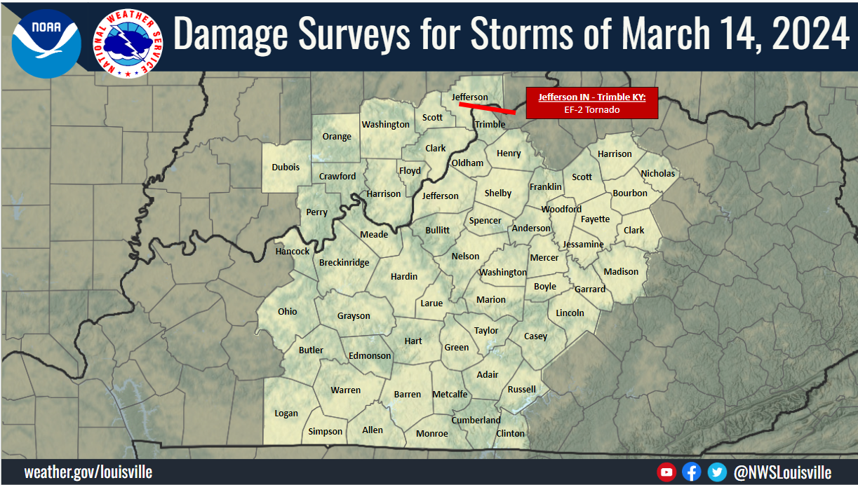
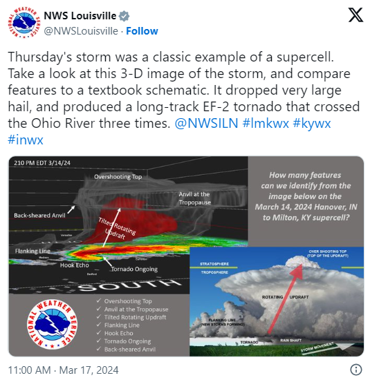
Severe storms pushed through the region on March 14-15, 2024. A supercell moving through southern Indiana and northern Kentucky led to a tornado forming over Hanover, Indiana, crossing the Ohio River into Milton, Kentucky, and then again crossing the Ohio River two more times before ending east of Carrollton, Kentucky. This tornado reached a maximum strength of 115 mph (EF2) and was on the ground for over 18 miles. In the overnight period of March 14-15, a strong line of thunderstorms brought 50-62 mph gusts through the region and quarter sized hail.
Have Storm Damage? Know of Some? We want your report.... You can fill out this form it's VERY IMPORTANT we have DATE, Best Guess Time it Occurred and your Location... |
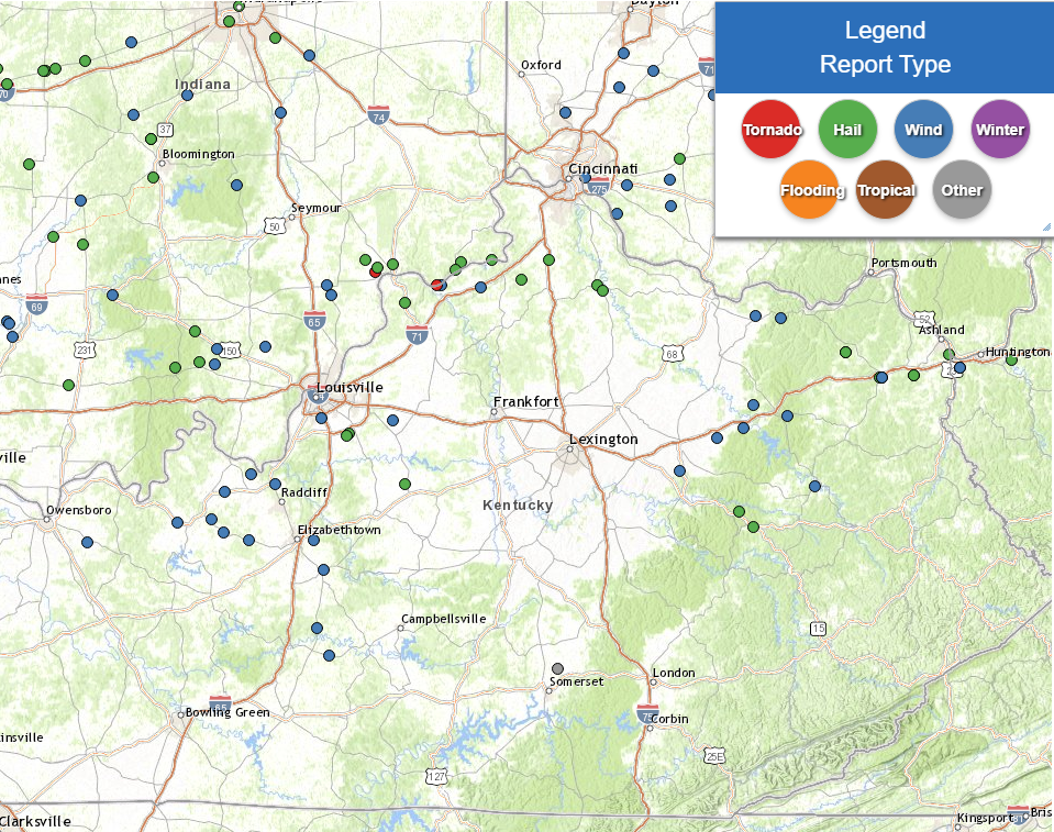
 Damage Survey Map |
Tornadoes:
Interactive Damage Survey Map - Zoom in and click the points to see damage information and pictures. All damage points are preliminary at this time. Performance of this map may be slow due to heavy internet traffic. **Zoom in to see very small, brief tornadoes.**

|
Tornado - Hanover, IN - Milton, KY
|
||||||||||||||||
The Enhanced Fujita (EF) Scale classifies tornadoes into the following categories:
| EF0 Weak 65-85 mph |
EF1 Moderate 86-110 mph |
EF2 Significant 111-135 mph |
EF3 Severe 136-165 mph |
EF4 Extreme 166-200 mph |
EF5 Catastrophic 200+ mph |
 |
|||||
Photos & Video
Drone Video near Hanover, IN
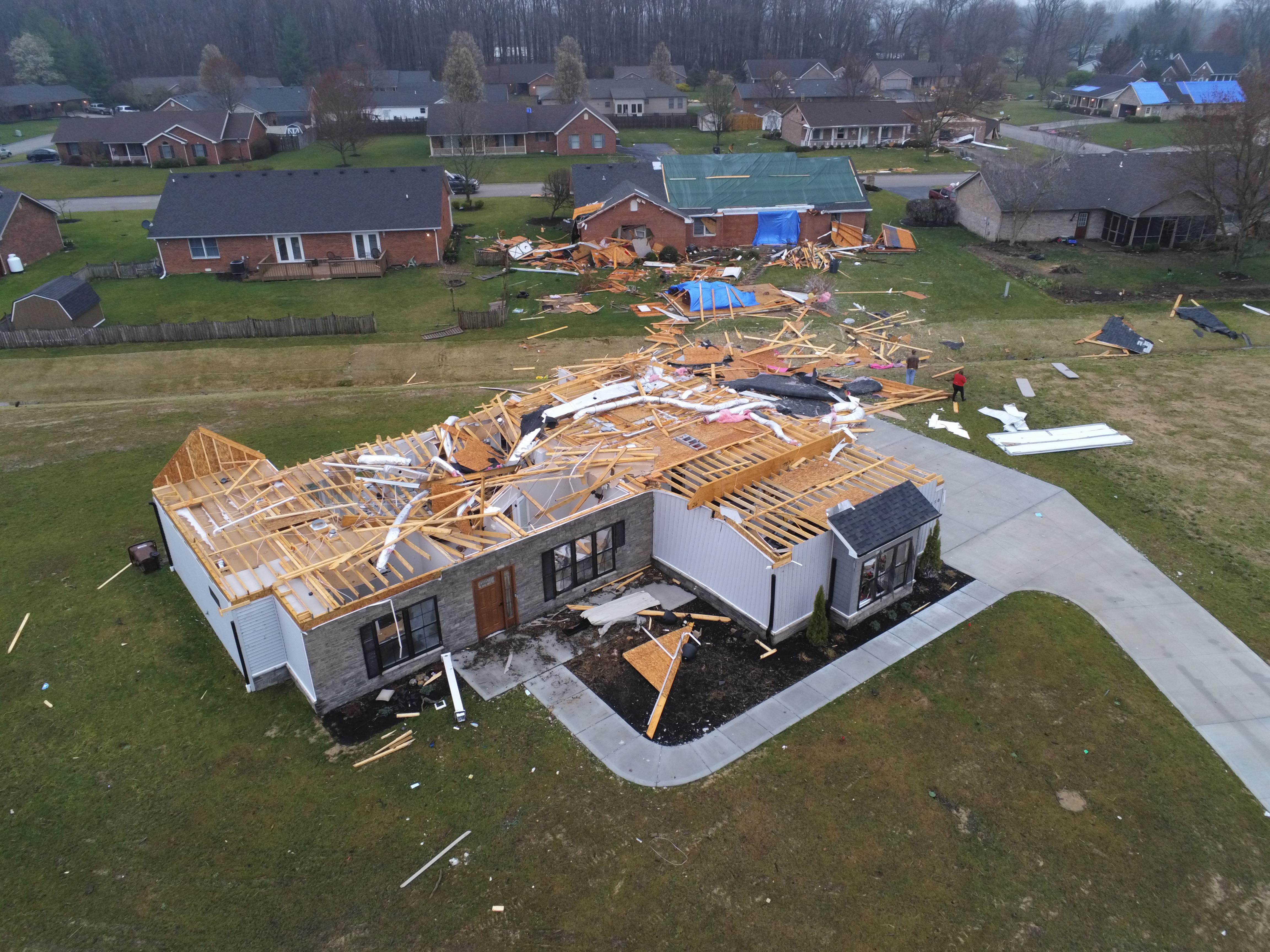 |
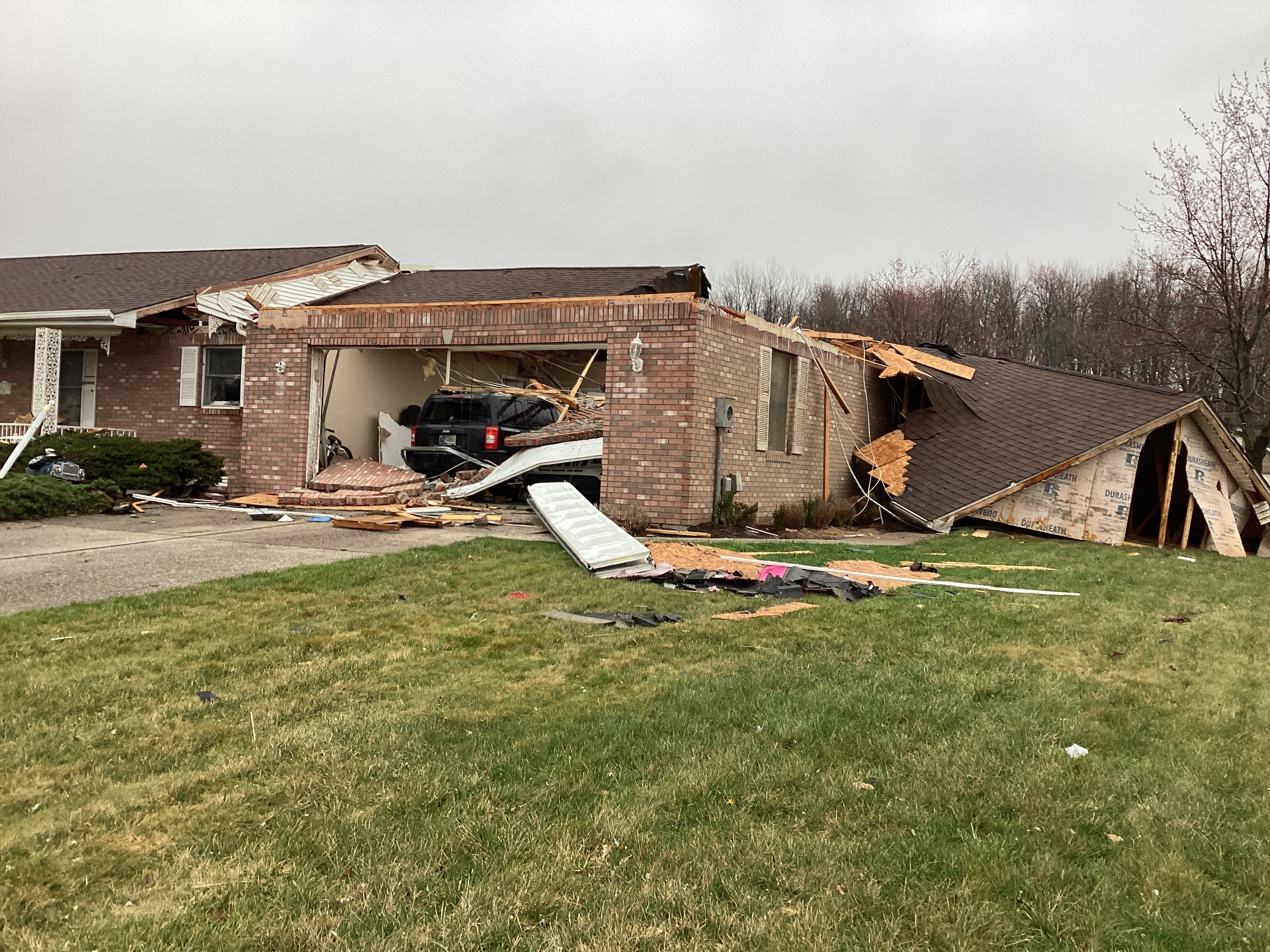 |
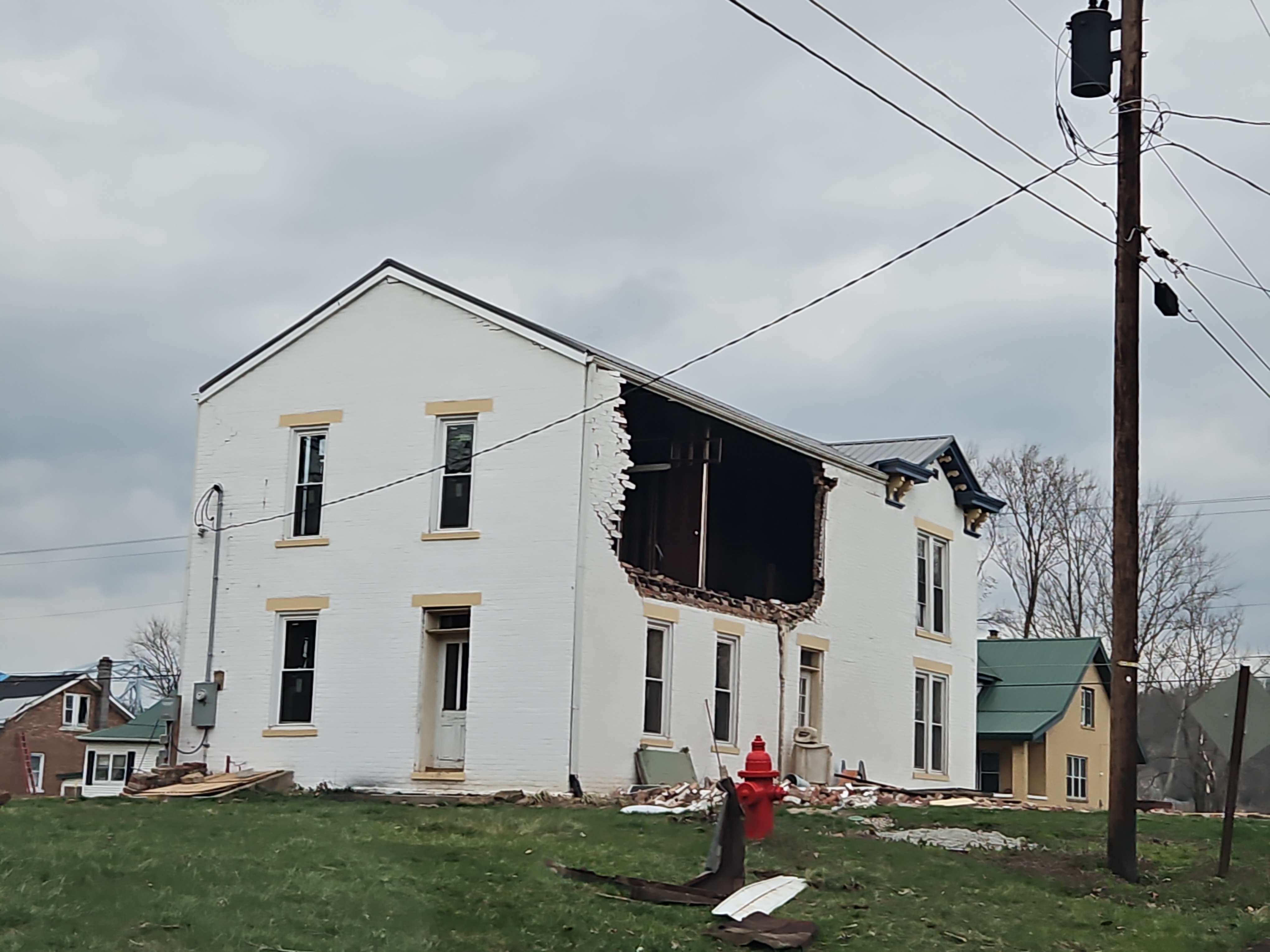 |
 |
| Drone image of damage near Hanover, IN. | Home damage near Hanover, IN. | Damage near Milton, KY. | EF2 damage near Sandy Beach Campground. |
Radar
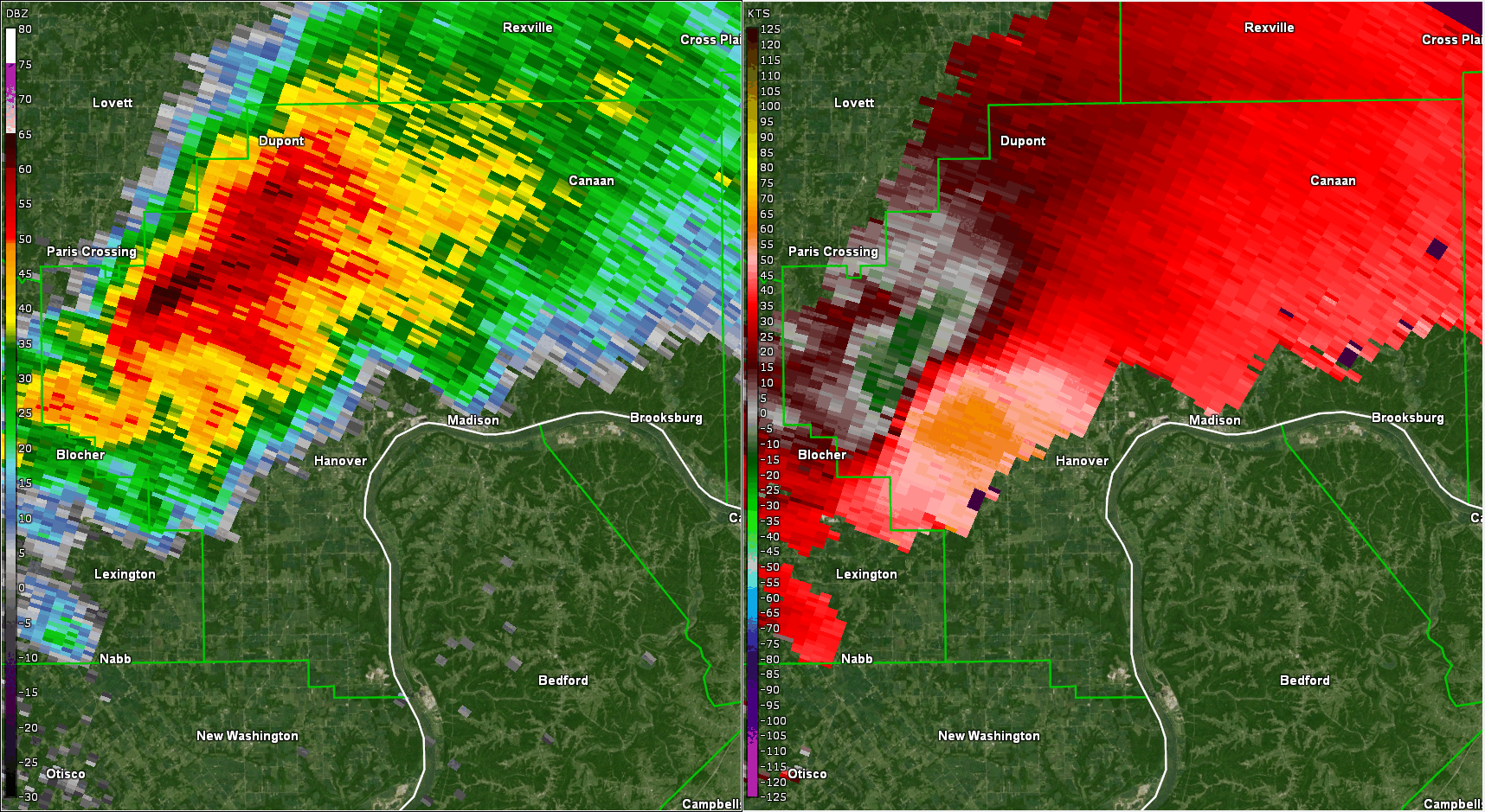 |
| Loop of Reflectivity and Velocity as the tornado-producing supercell crossed Jefferson and Trimble County |
Storm Reports
..TIME... ...EVENT... ...CITY LOCATION... ...LAT.LON...
..DATE... ....MAG.... ..COUNTY LOCATION..ST.. ...SOURCE....
..REMARKS..
1051 PM Hail 2 N Bedford 38.62N 85.32W
03/14/2024 E1.00 inch Trimble KY Emergency Mngr
1220 AM Tstm Wnd Gst 4 WNW Finchville 38.16N 85.38W
03/15/2024 M51 MPH Shelby KY Mesonet
Shelby County Mesonet site.
1218 AM Hail Bloomfield 37.91N 85.32W
03/15/2024 E1.00 inch Nelson KY Public
1141 PM Tstm Wnd Dmg Guston 37.88N 86.22W
03/14/2024 Meade KY 911 Call Center
Trees down in the area of US 60 and State
Road 428. Trees have since been removed.
1146 PM Tstm Wnd Dmg 4 NNE Garrett 37.95N 86.09W
03/14/2024 Meade KY 911 Call Center
Corrects time of previous tstm wnd dmg
report from 4 NNE Garrett. Trees down on the
3000 block of State Road 1638. Trees have
since been removed.
1230 AM Tstm Wnd Dmg Hodgenville 37.57N 85.73W
03/15/2024 Larue KY Public
Large tree down on Miller Road.
1053 PM Hail 3 SSE Highview 38.10N 85.61W
03/14/2024 E1.00 inch Jefferson KY NWS Employee
1054 PM Hail 2 SE Highview 38.11N 85.60W
03/14/2024 M1.00 inch Jefferson KY NWS Employee
1158 PM Tstm Wnd Gst Louisville Int'l Airpor 38.17N 85.74W
03/14/2024 M52 MPH Jefferson KY ASOS
Measured gust at SDF ASOS.
1229 AM Tstm Wnd Dmg 1 NE Linwood 37.34N 85.76W
03/15/2024 Hart KY Fire Dept/Rescue
Tree down in the Linwood Community.
1239 AM Tstm Wnd Dmg Monroe 37.23N 85.70W
03/15/2024 Hart KY Fire Dept/Rescue
Two trees down in the Monroe Community.
1157 PM Tstm Wnd Gst Fort Knox 37.91N 85.97W
03/14/2024 M56 MPH Hardin KY ASOS
Fort Knox ASOS.
1202 AM Tstm Wnd Dmg 1 WNW Howe Valley 37.69N 86.10W
03/15/2024 Hardin KY 911 Call Center
Tree down on Hardinsburg Road.
1213 AM Tstm Wnd Dmg 5 E Elizabethtown 37.69N 85.78W
03/15/2024 Hardin KY 911 Call Center
Tree down on Valley Creek Road.
1110 PM Tstm Wnd Gst 1 SSW Hardinsburg 37.76N 86.46W
03/14/2024 M62 MPH Breckinridge KY Mesonet
1142 PM Tstm Wnd Dmg 3 ESE Garfield 37.77N 86.29W
03/14/2024 Breckinridge KY Broadcast Media
Tree across Rosetta Road near
Stinnettsville.
1146 PM Tstm Wnd Dmg 1 SE Custer 37.72N 86.23W
03/14/2024 Breckinridge KY Fire Dept/Rescue
Power lines down on the 4500 block of State
Road 86.
1054 AM Tstm Wnd Dmg 2 SSE Hardinsburg 38.44N 86.26W
03/14/2024 Washington IN 911 Call Center
Tree down on State Road 66 near Pirtle Road.
1107 PM Tstm Wnd Dmg 1 ENE Martinsburg 38.45N 86.02W
03/14/2024 Washington IN 911 Call Center
Tree down on State Road 335 near Lovell
Road.
1134 PM Tstm Wnd Dmg 4 W Lexington 38.65N 85.69W
03/14/2024 Scott IN Emergency Mngr
Tree down on State Road 3.
1136 PM Tstm Wnd Dmg 3 S New Frankfort 38.69N 85.71W
03/14/2024 Scott IN Emergency Mngr
Tree down on State Road 203 at State Road 3.
1112 PM Hail 1 ESE Chambersburg 38.51N 86.37W
03/14/2024 E1.00 inch Orange IN 911 Call Center
0158 PM Hail Volga 38.79N 85.52W
03/14/2024 E2.25 inch Jefferson IN Public
0158 PM Tornado 1 N Hanover 38.74N 85.47W
03/14/2024 Jefferson IN NWS Storm Survey
*** 2 INJ ***
An NWS storm survey found a 18.4 mile long
EF-2 tornado with peak winds of 115 mph
occurred on the afternoon of March 14, 2024.
The tornado was on the ground for 22 minutes
as it touched down 1 mile north of Hanover,
IN, and lifted in Switzerland county, IN
just across the Ohio River from Carrolton,
KY. This tornado crossed the Ohio River
three times, including paralleling the river for a
couple miles as the southern edge of the
funnel damaged Milton, KY. The max path
width was 500 yards wide at its max.
0200 PM Hail 3 SSW Wirt 38.76N 85.46W
03/14/2024 E2.00 inch Jefferson IN Public
0205 PM Hail 1 ENE North Madison 38.77N 85.38W
03/14/2024 M1.50 inch Jefferson IN Public
1045 PM Hail 2 W Huntingburg 38.30N 87.00W
03/14/2024 E1.00 inch Dubois IN Public
1031 PM Hail 2 ESE Brownstown 38.37N 86.47W
03/14/2024 M1.00 inch Crawford IN Trained Spotter
1048 PM Hail 1 N Marengo 38.39N 86.35W
03/14/2024 E1.00 inch Crawford IN Public
1115 PM Tstm Wnd Dmg 2 N Milltown 38.38N 86.27W
03/14/2024 Crawford IN Law Enforcement
Several telephone poles down on State Road
66.
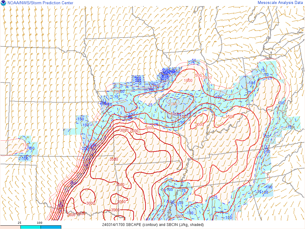
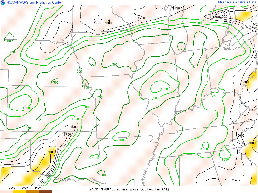
Environment
Thermodynamic and Instability Parameters.
 |
 |
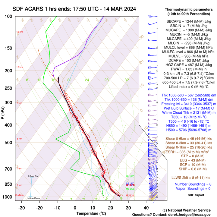 |
| Surface-based CAPE at 17Z (1 PM EDT) 03/14/24 | Lifting Condensation Level heights at 17Z (1 PM EDT) 03/14/24 | ACARS Sounding Profile from Louisville |
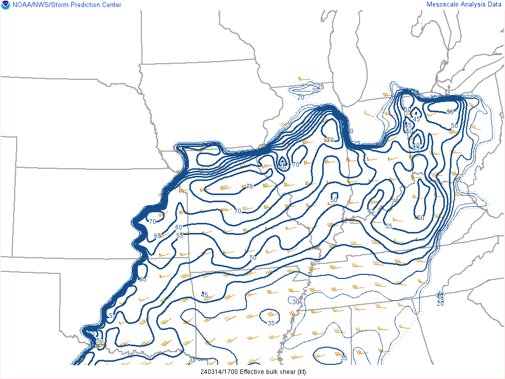
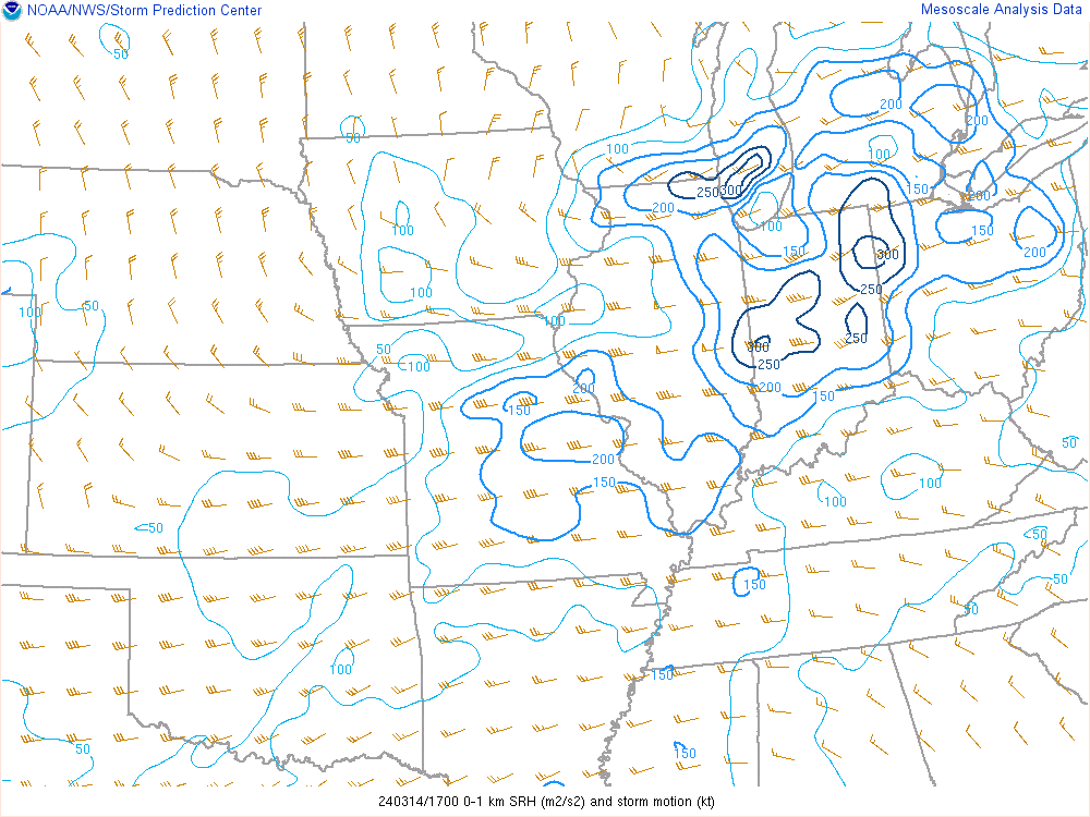
Wind Shear Parameters.
 |
 |
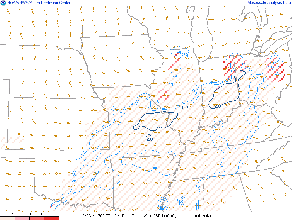 |
| Effective Bulk Shear at 17Z (1 PM EDT) 03/14/24 | 0-1 km Storm-Relative Helicity at 17Z (1 PM EDT) 03/14/24 | Effective SRH at 17Z (1 PM EDT) 03/14/24 |
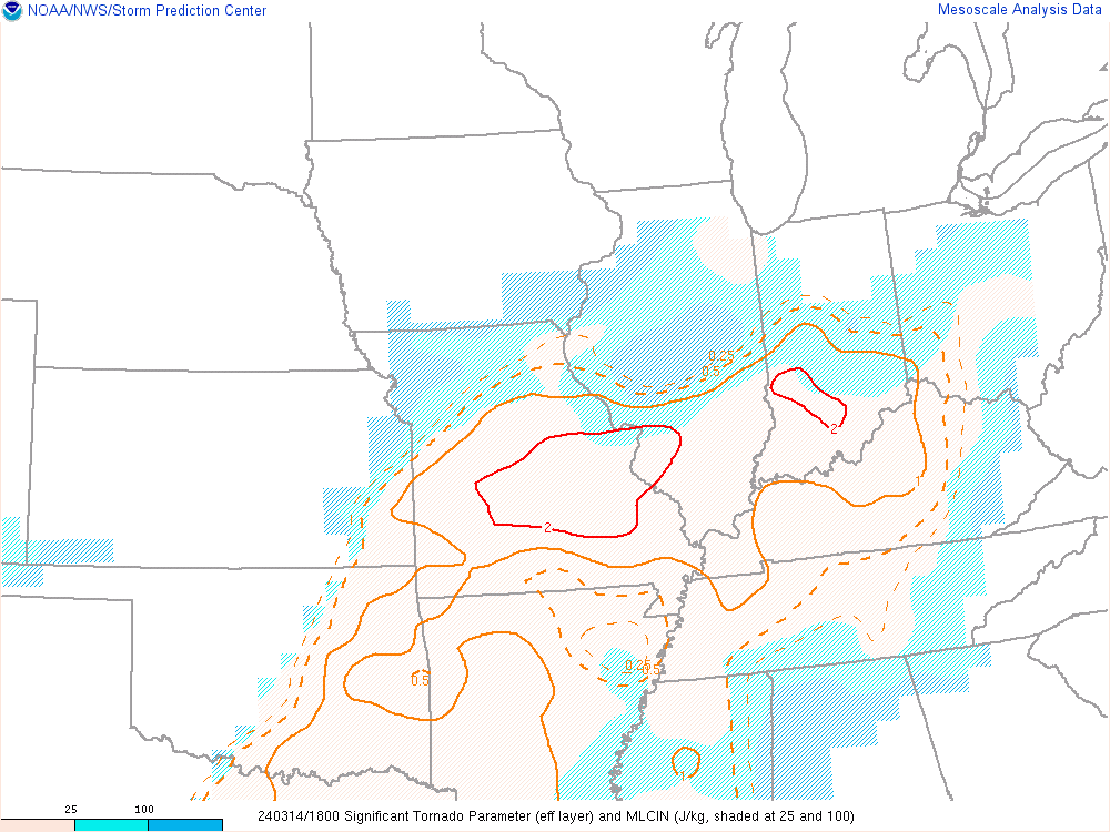
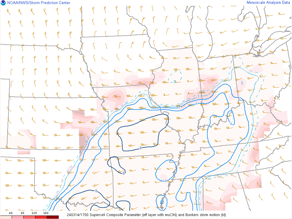
Composite Parameters.
 |
 |
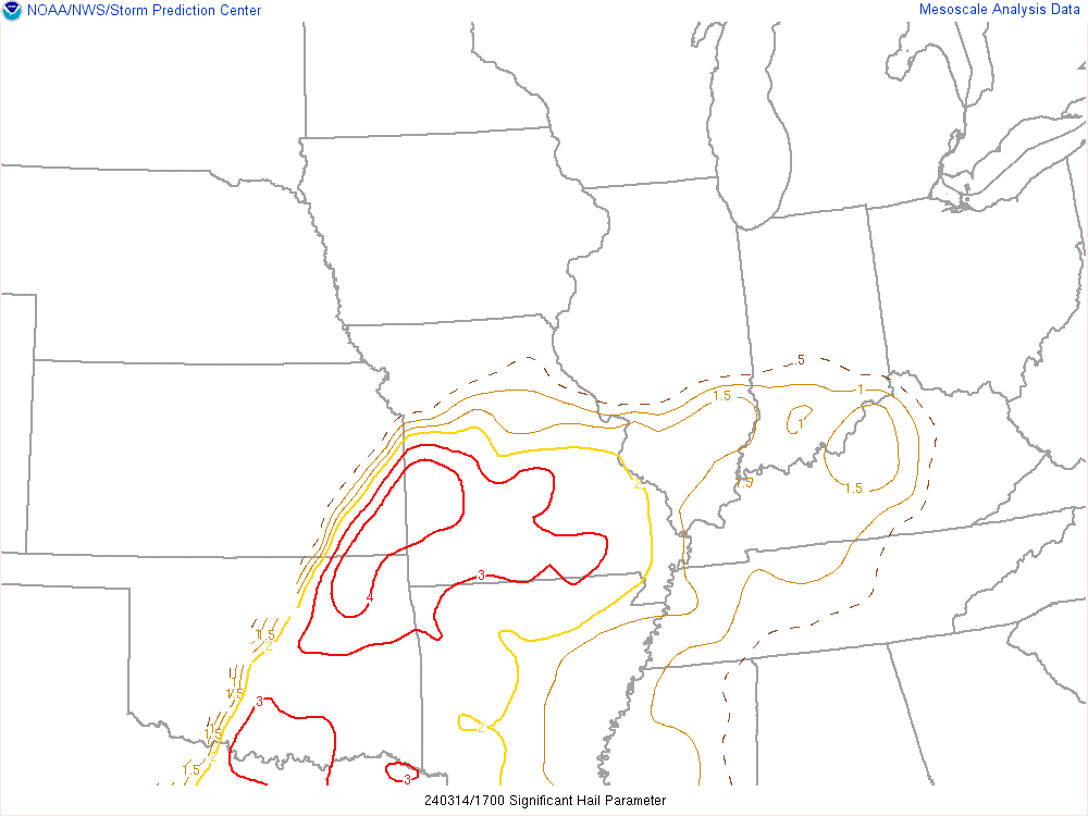 |
| Significant Tornado Parameter at 18Z (2 PM EDT) 03/14/24 | Supercell Composite Parameter at 17Z (1 PM EDT) 03/14/24 | Significant Hail Parameter at 17Z (1 PM EDT) 03/14/24 |
 |
Media use of NWS Web News Stories is encouraged! Please acknowledge the NWS as the source of any news information accessed from this site. |
|


 Weather Story
 Weather Map
 Local Radar