Overview
|
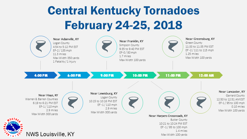
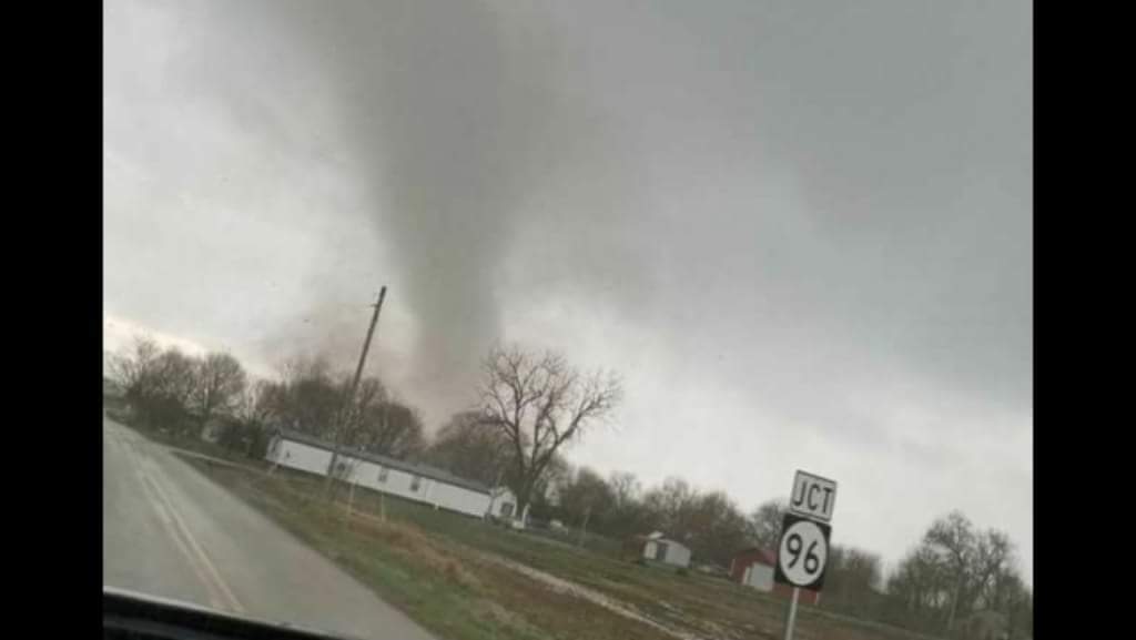
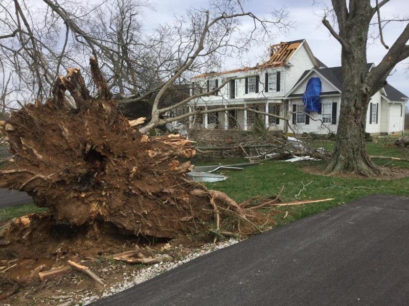
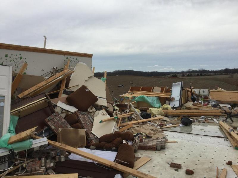
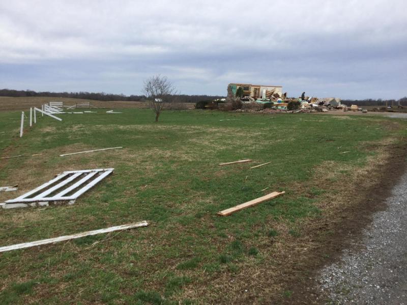
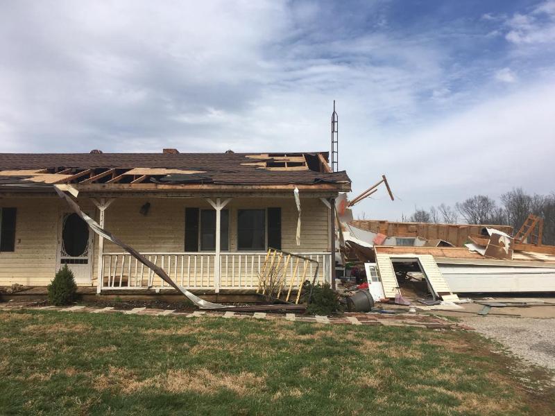
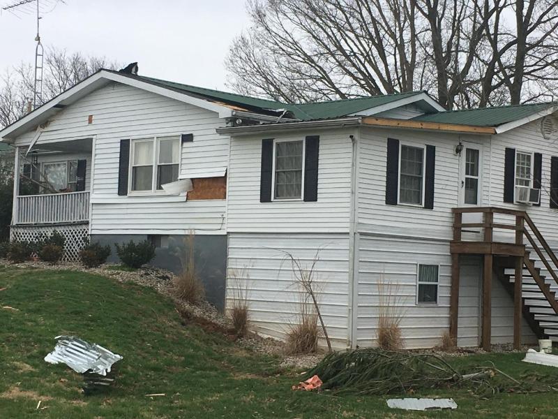
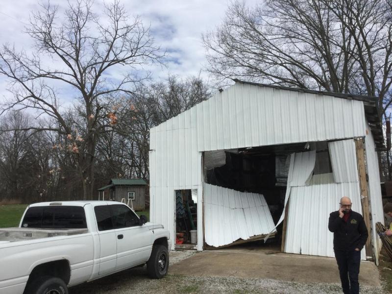
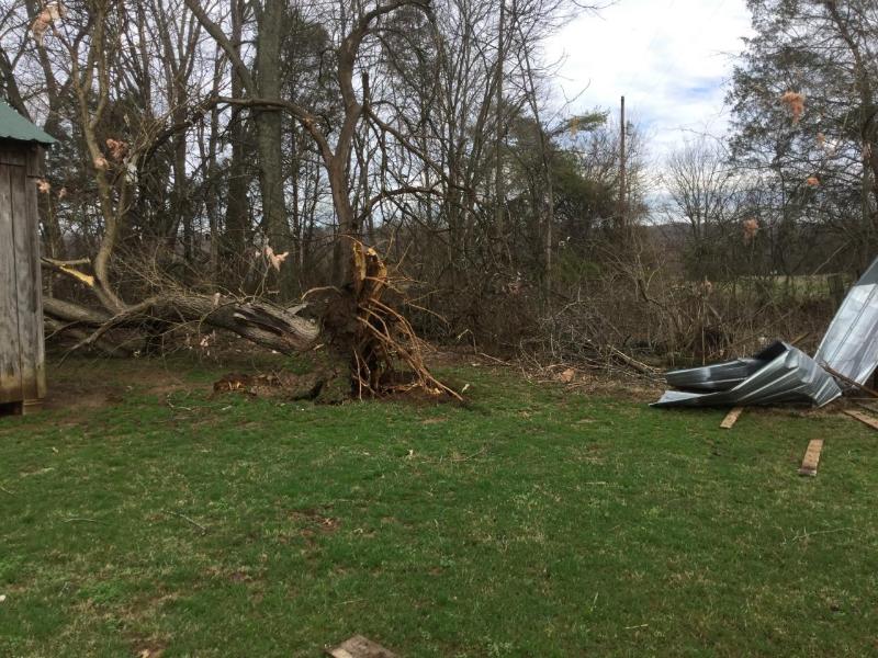
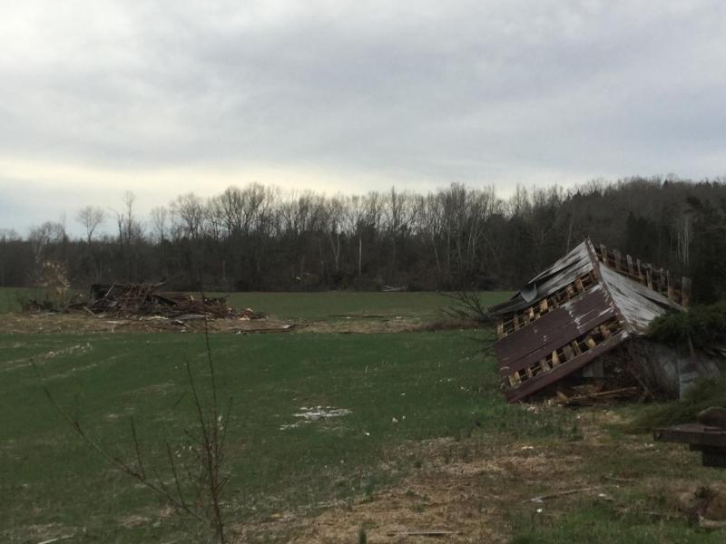
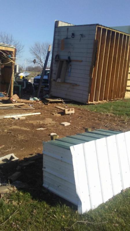
Widespread flash flooding and several tornadoes occurred across central Kentucky and southern Indiana from the afternoon hours February 24 through the early morning February 25. Seven tornadoes were confirmed across central Kentucky.
|
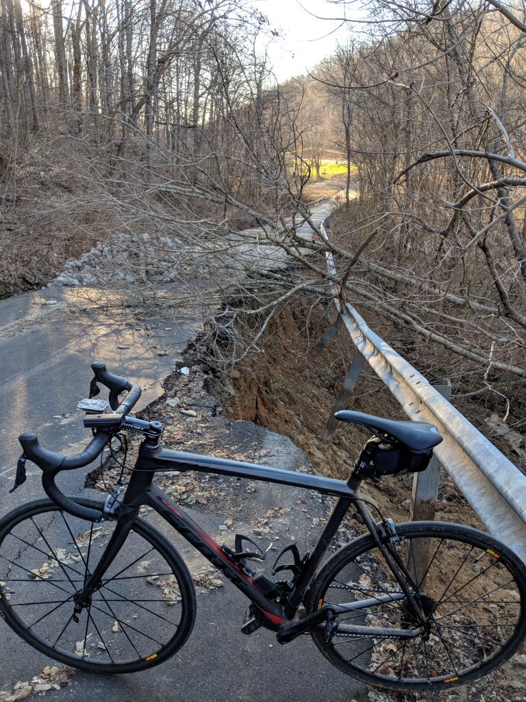
Tornado near Keysburg, KY in southern Logan County. Photo Credit: Lori Henderson |
Tornadoes:
|
|
||||||||||
|
||||||||||
|
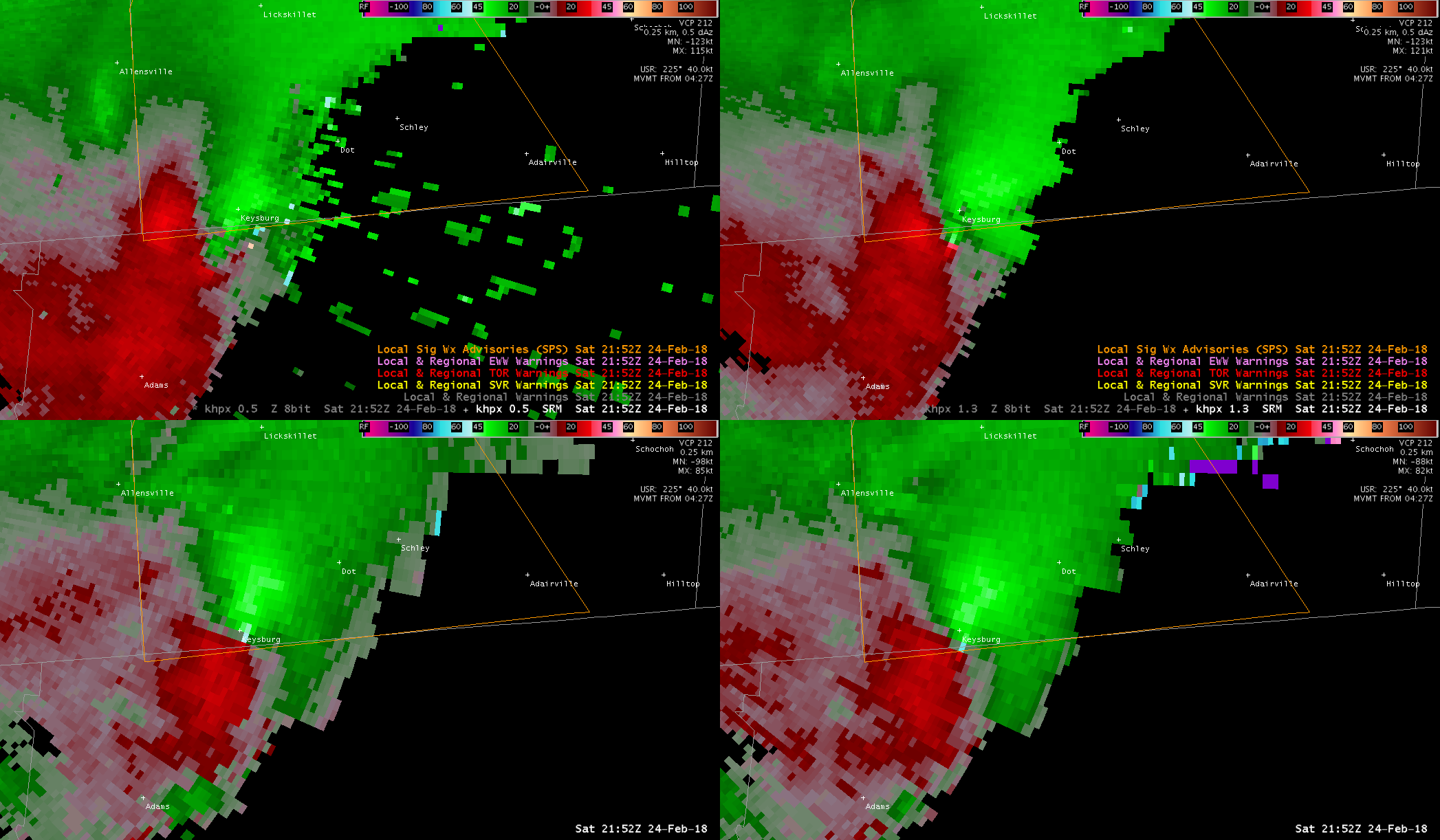
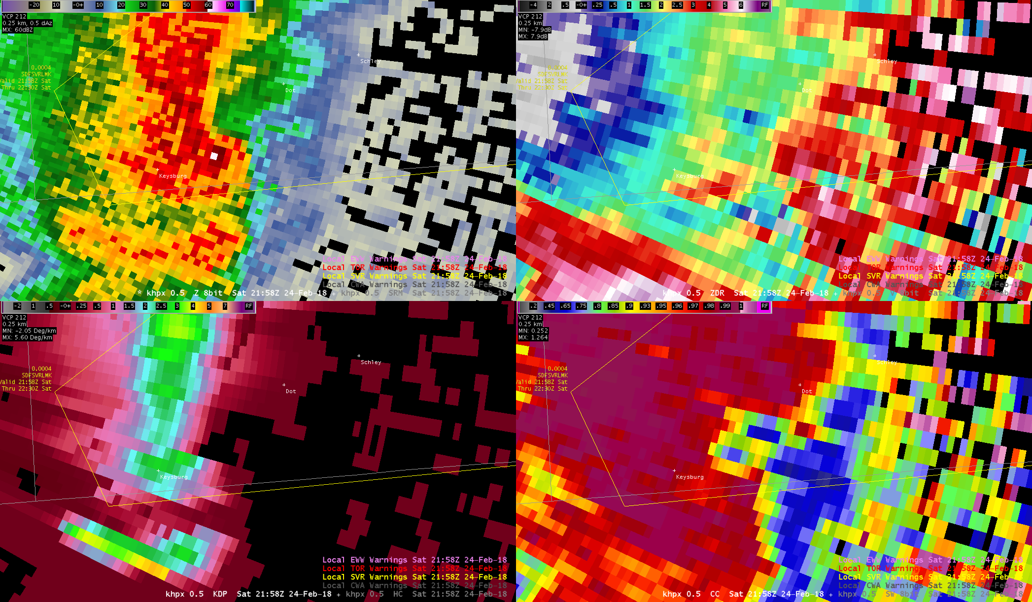
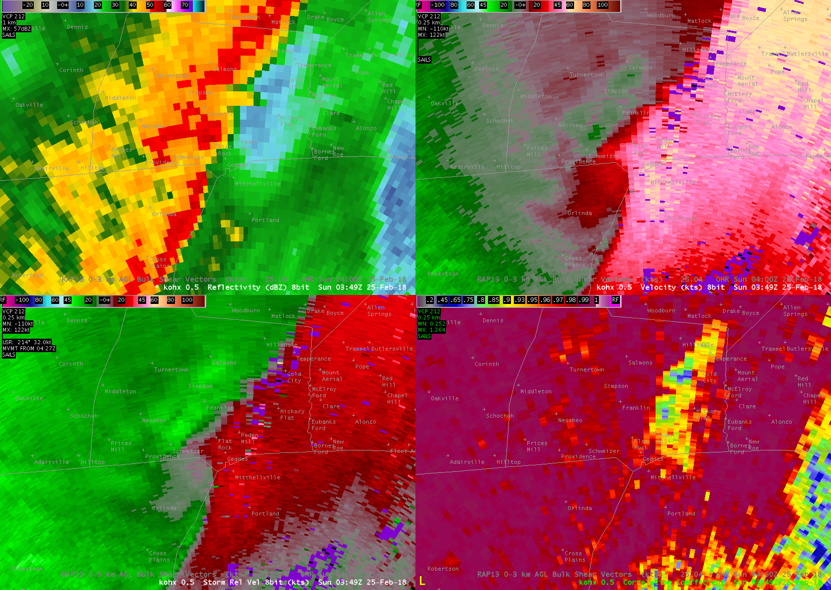
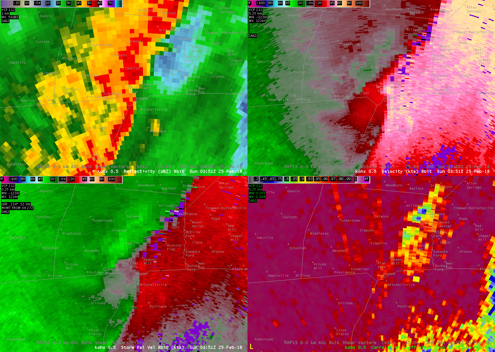
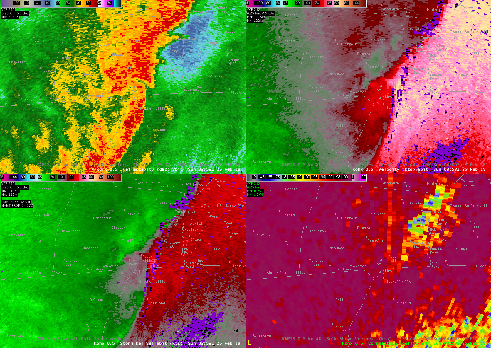
Tornado - Near Adairville, KY
Track Map 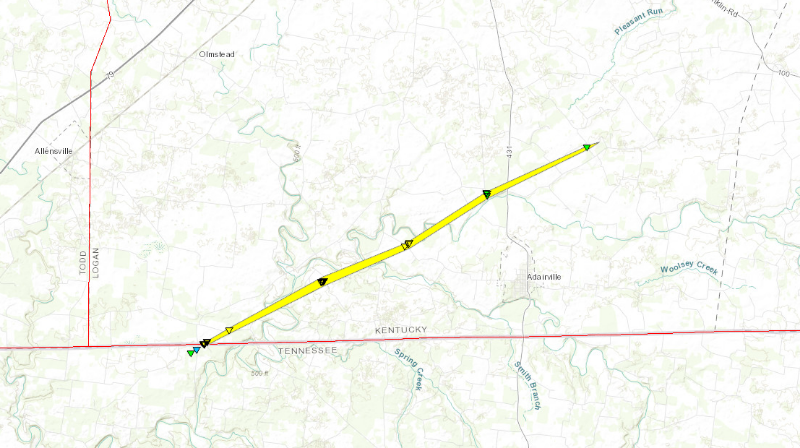 
|
||||||||||||||||||||||||
|
||||||||||||||||||||||||
|
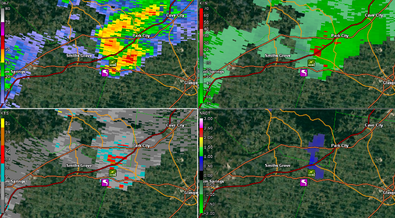
Tornado - Near Hays, KY
Track Map 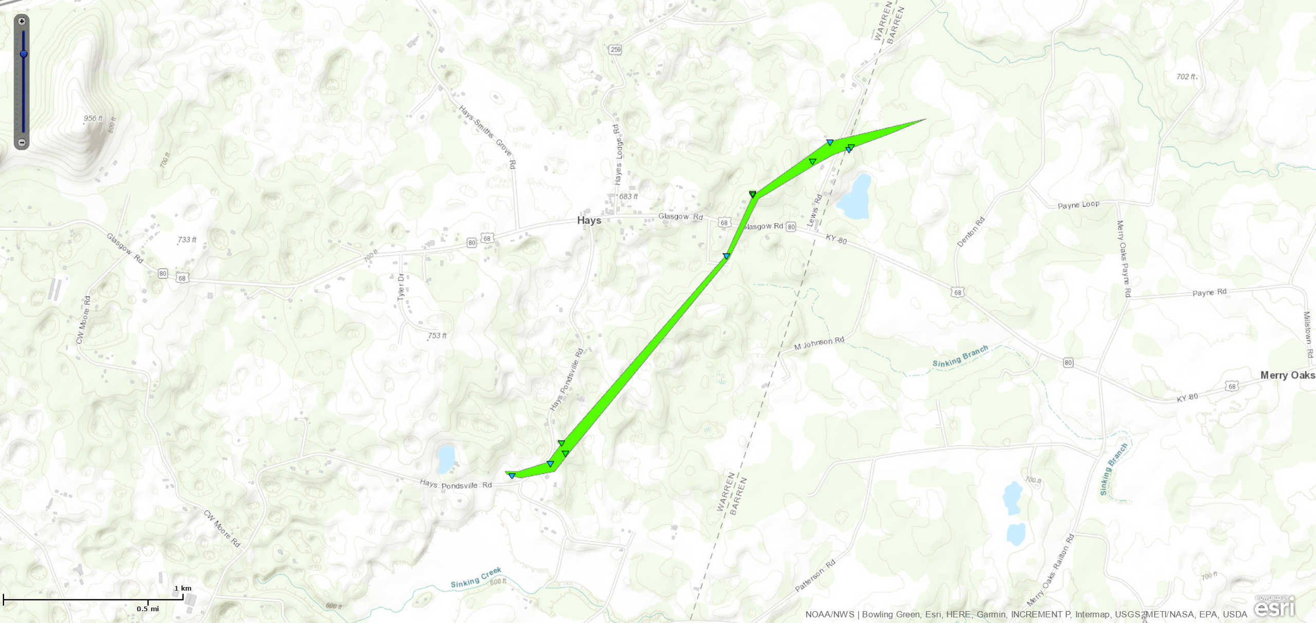
|
||||||||||||||||
|
||||||||||||||||
|
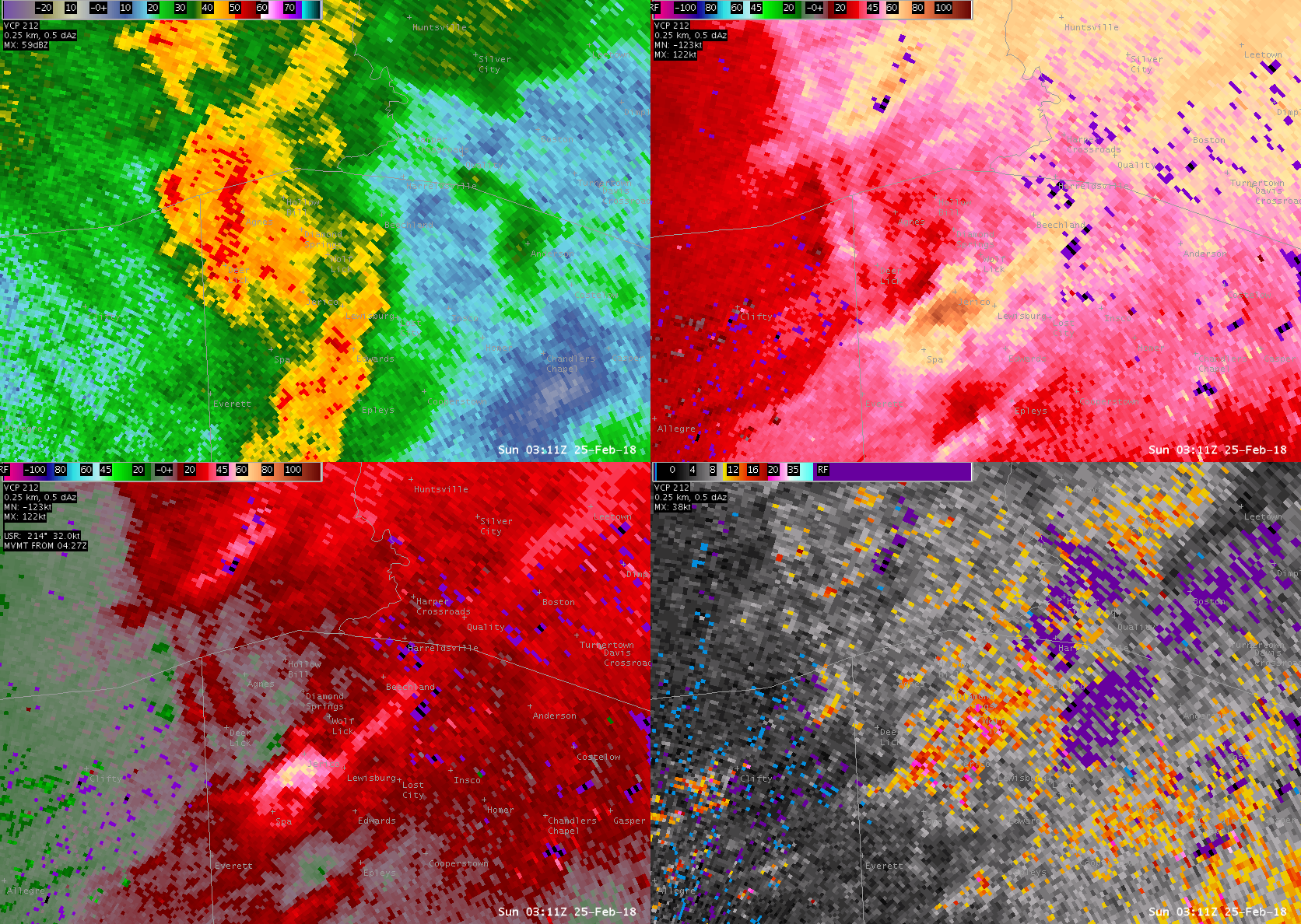
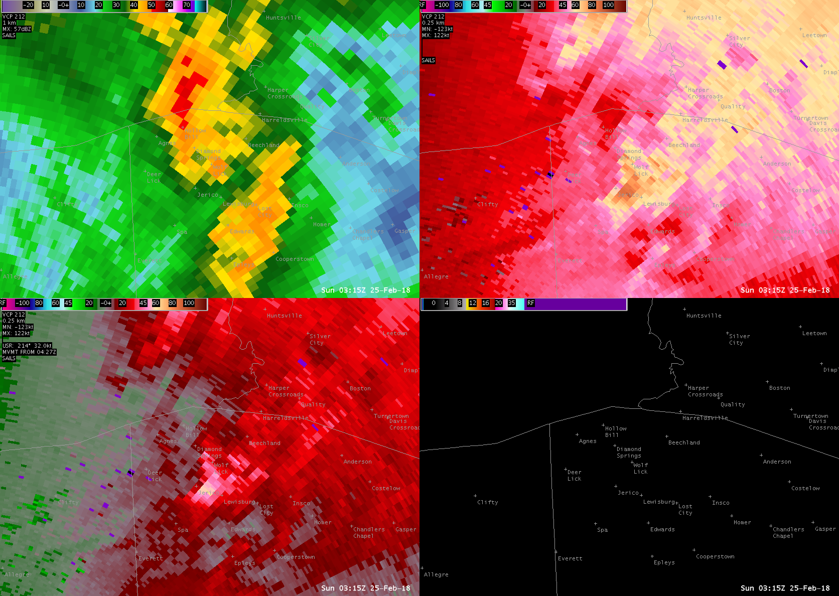
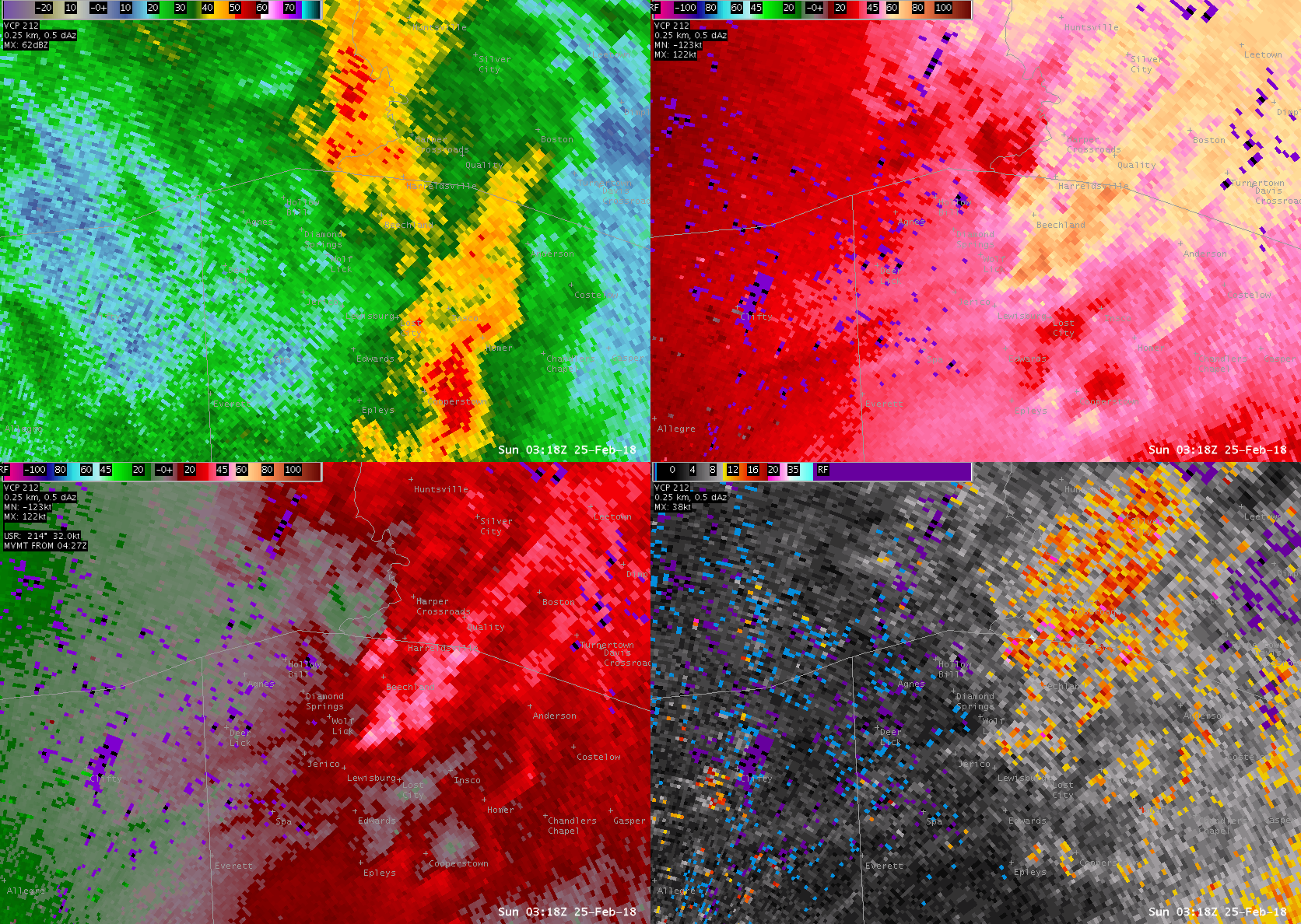
Tornado - Near Lewisburg, KY
Track Map 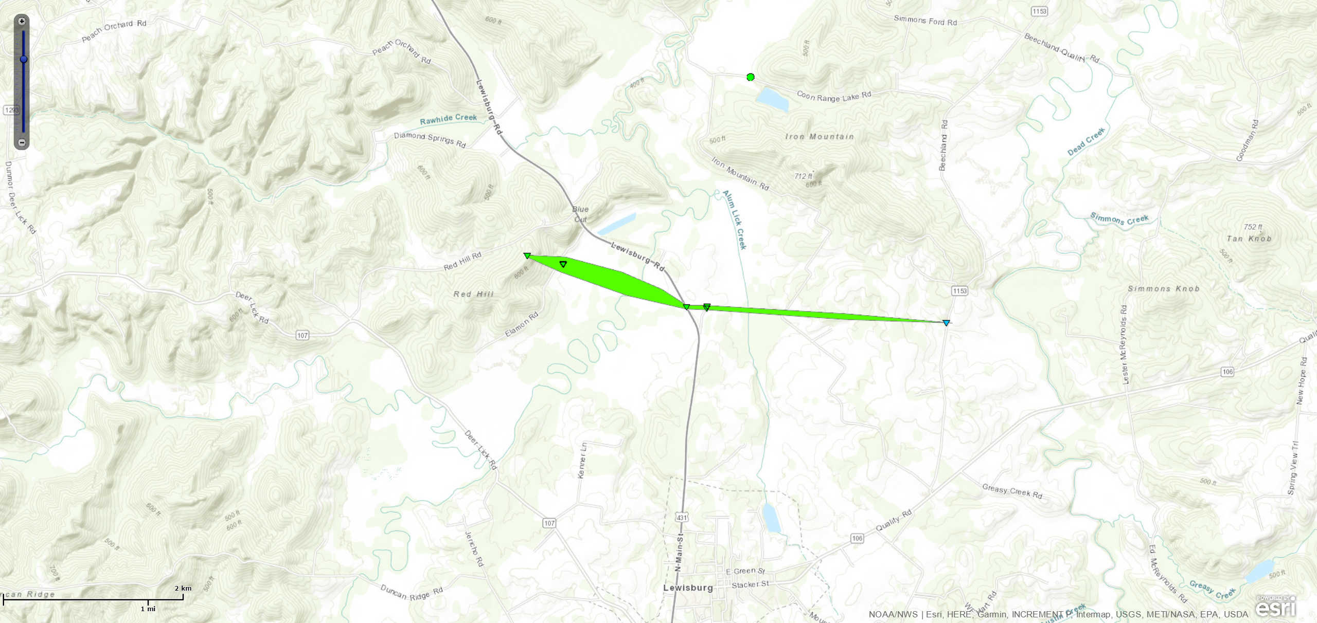
|
||||||||||||||||
|
||||||||||||||||
|
Tornado - near Lancaster, KY
Track Map 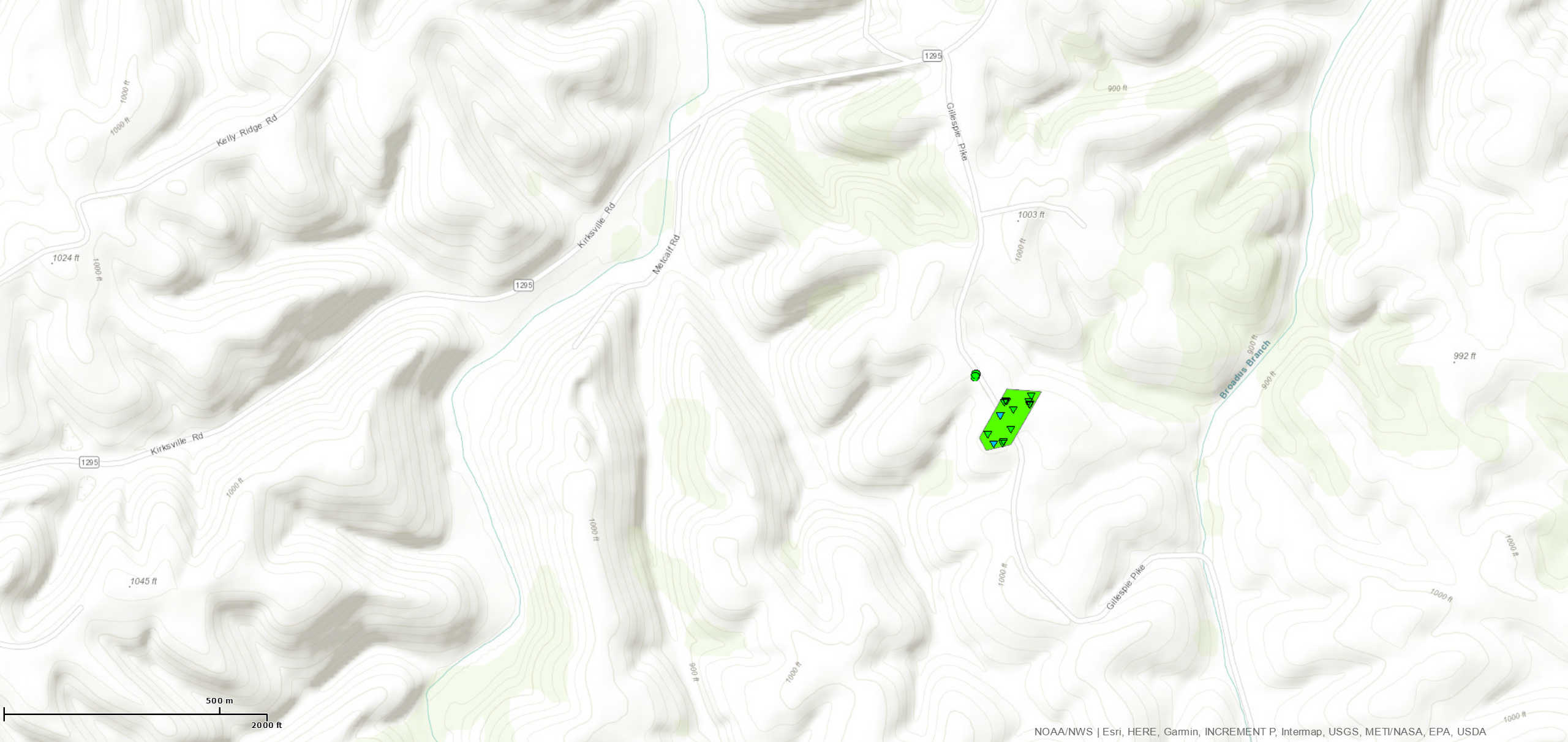
|
||||||||||||||||
|
||||||||||||||||
|
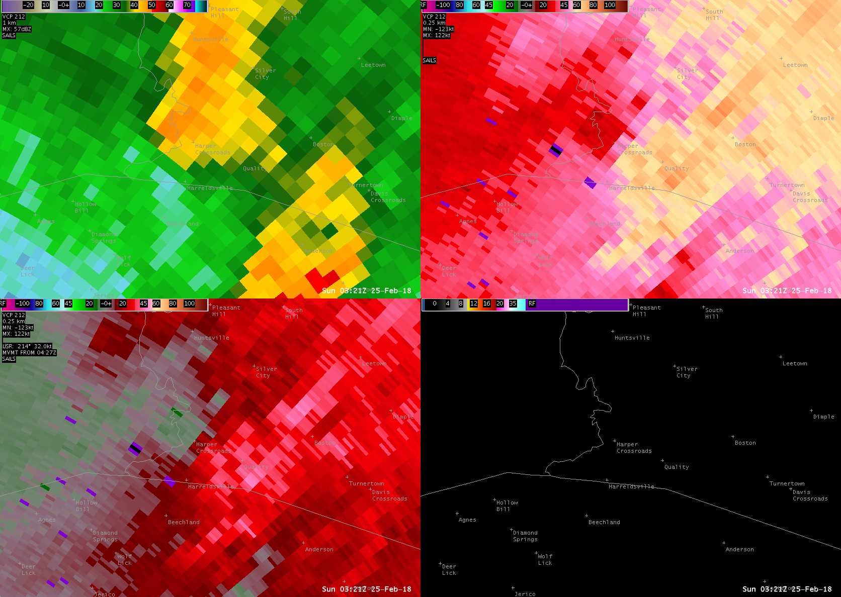
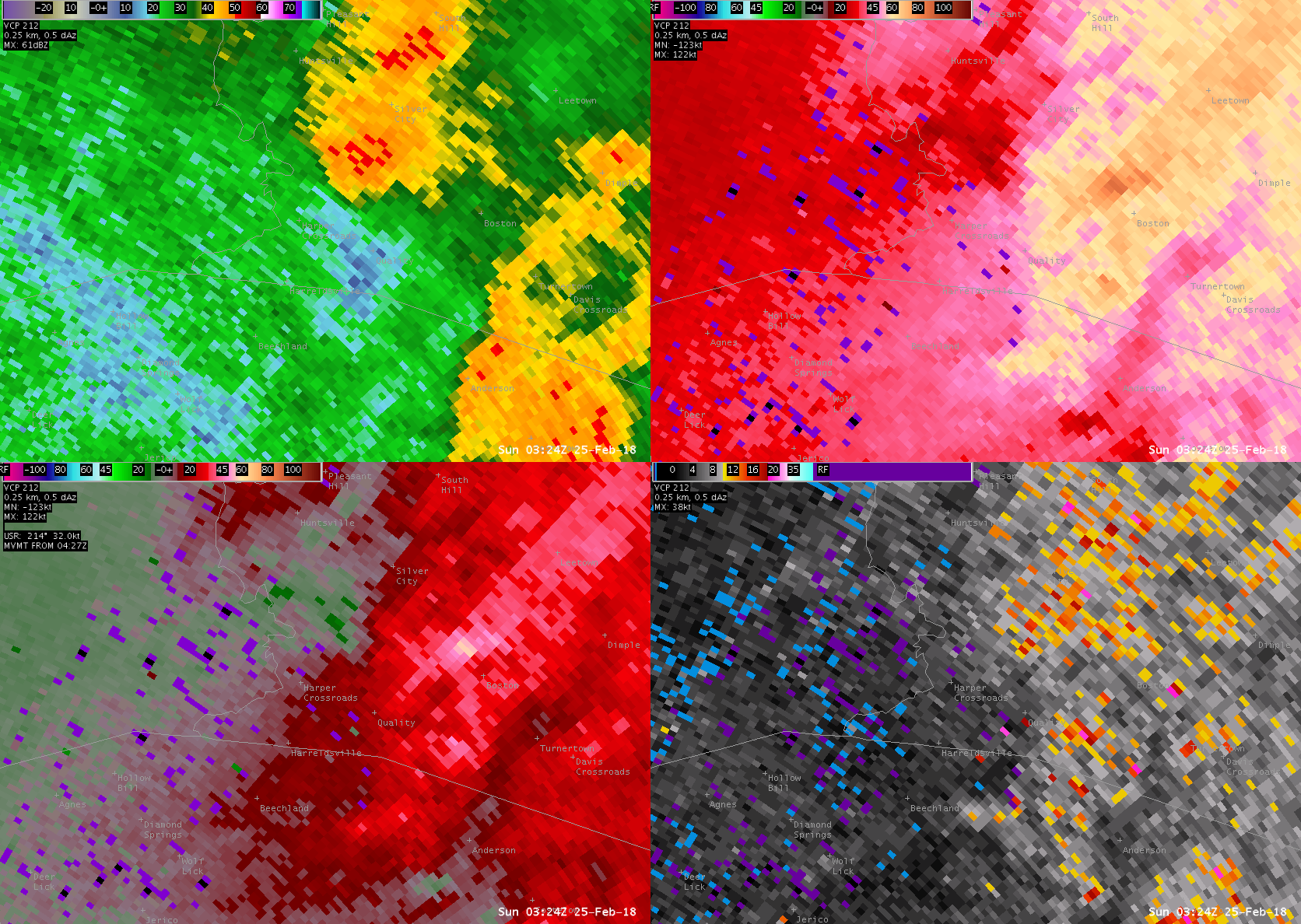
Tornado - near Harpers Crossroads, KY
Track Map 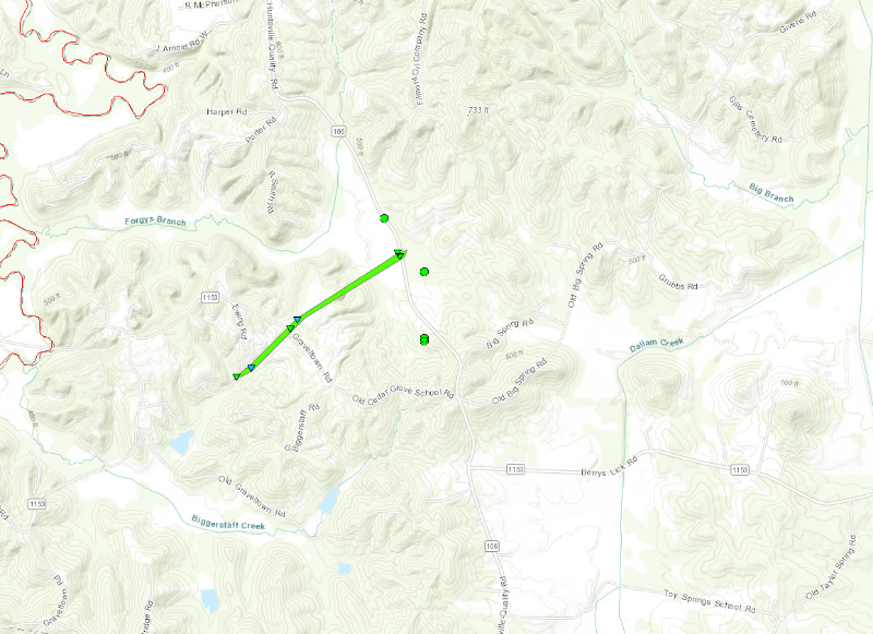
|
||||||||||||||||
|
||||||||||||||||
|
Tornado - near Greensburg, KY
Track Map 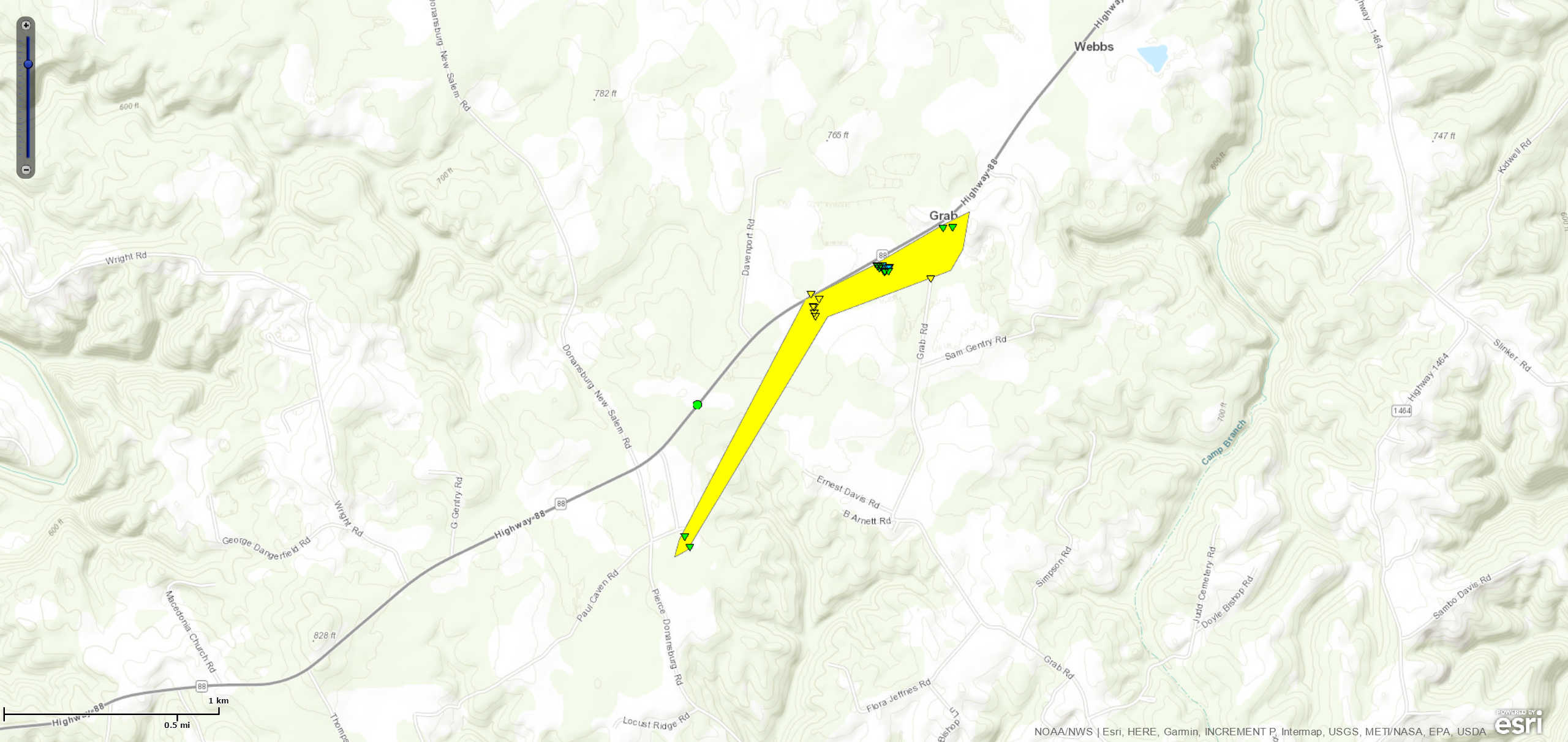
|
||||||||||||||||
|
||||||||||||||||
|
Tornado - south of Franklin, KY
Track Map 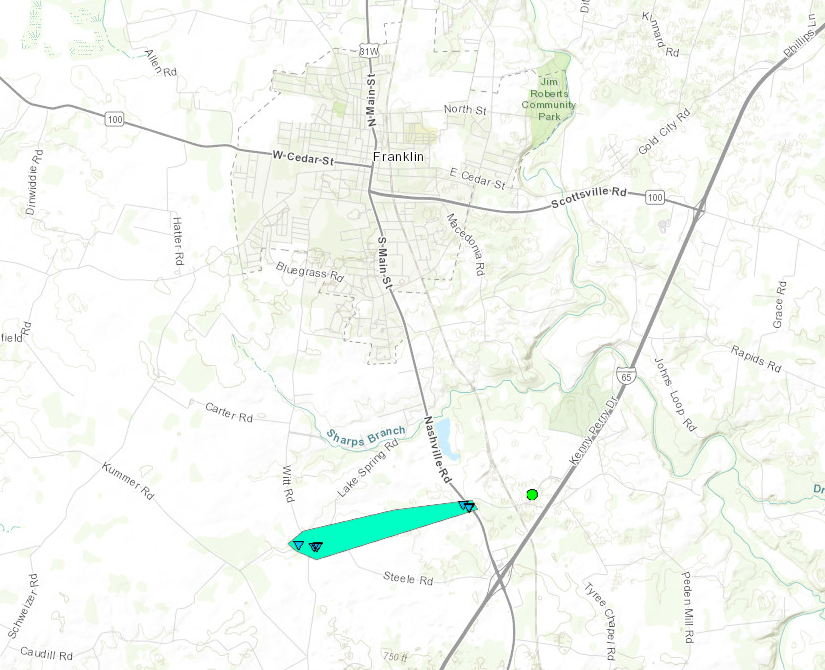
|
||||||||||||||||
|
||||||||||||||||
The Enhanced Fujita (EF) Scale classifies tornadoes into the following categories:
| EF0 Weak 65-85 mph |
EF1 Moderate 86-110 mph |
EF2 Significant 111-135 mph |
EF3 Severe 136-165 mph |
EF4 Extreme 166-200 mph |
EF5 Catastrophic 200+ mph |
 |
|||||
Wind:
Casey County
 |
 |
| Casey County | Casey County |
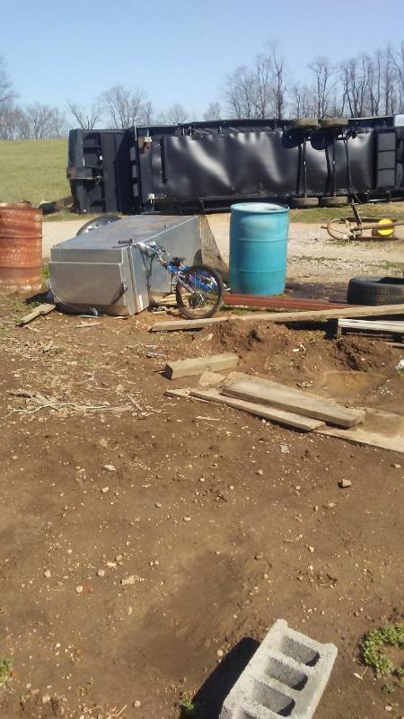
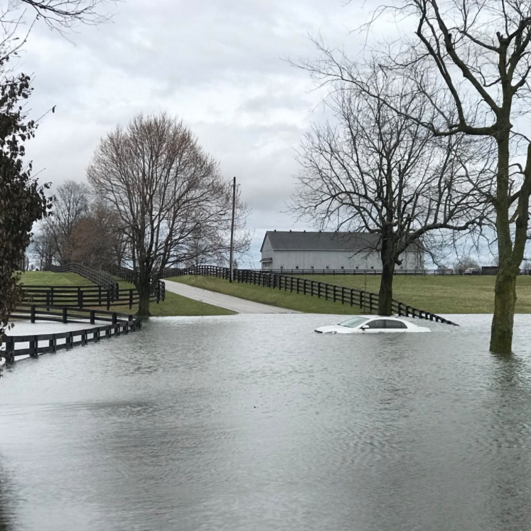
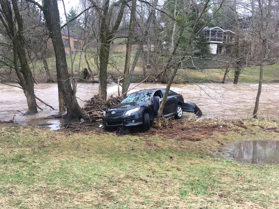
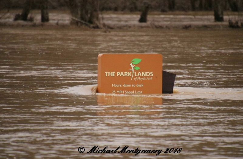
Flooding
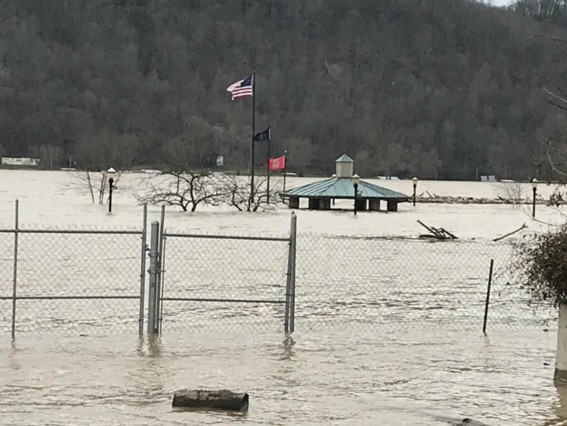
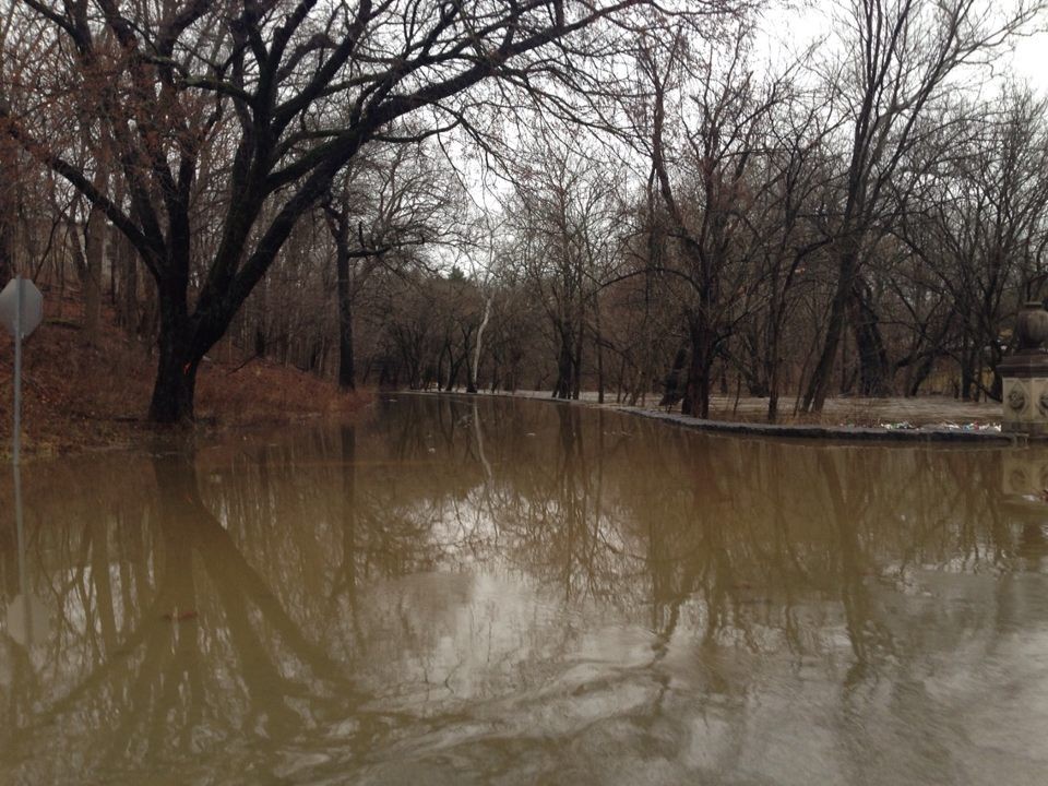
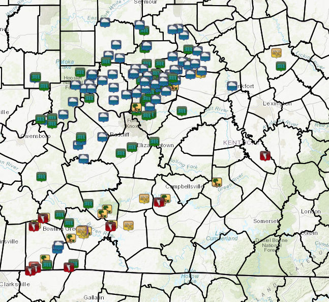
Widespread flash flooding occurred late Saturday night as repeated rounds of thunderstorms tracked over the region. Many creeks, streams, and urban areas experienced significant water rises and flash flooding. There were over 50 water rescues in Jefferson County, Kentucky alone that evening and a Flash Flood Emergency was issued during the evening hours.
Flash Flooding
 |
 |
 |
 |
| Woodford County | Seneca Park (Jefferson County KY) | The Parklands (Jefferson County KY) | Weavers Run Rd (Bullitt County KY) |
 |
 |
| Madison, IN (Jefferson County IN) | Cherokee Park (Jefferson County, KY) |
Radar:
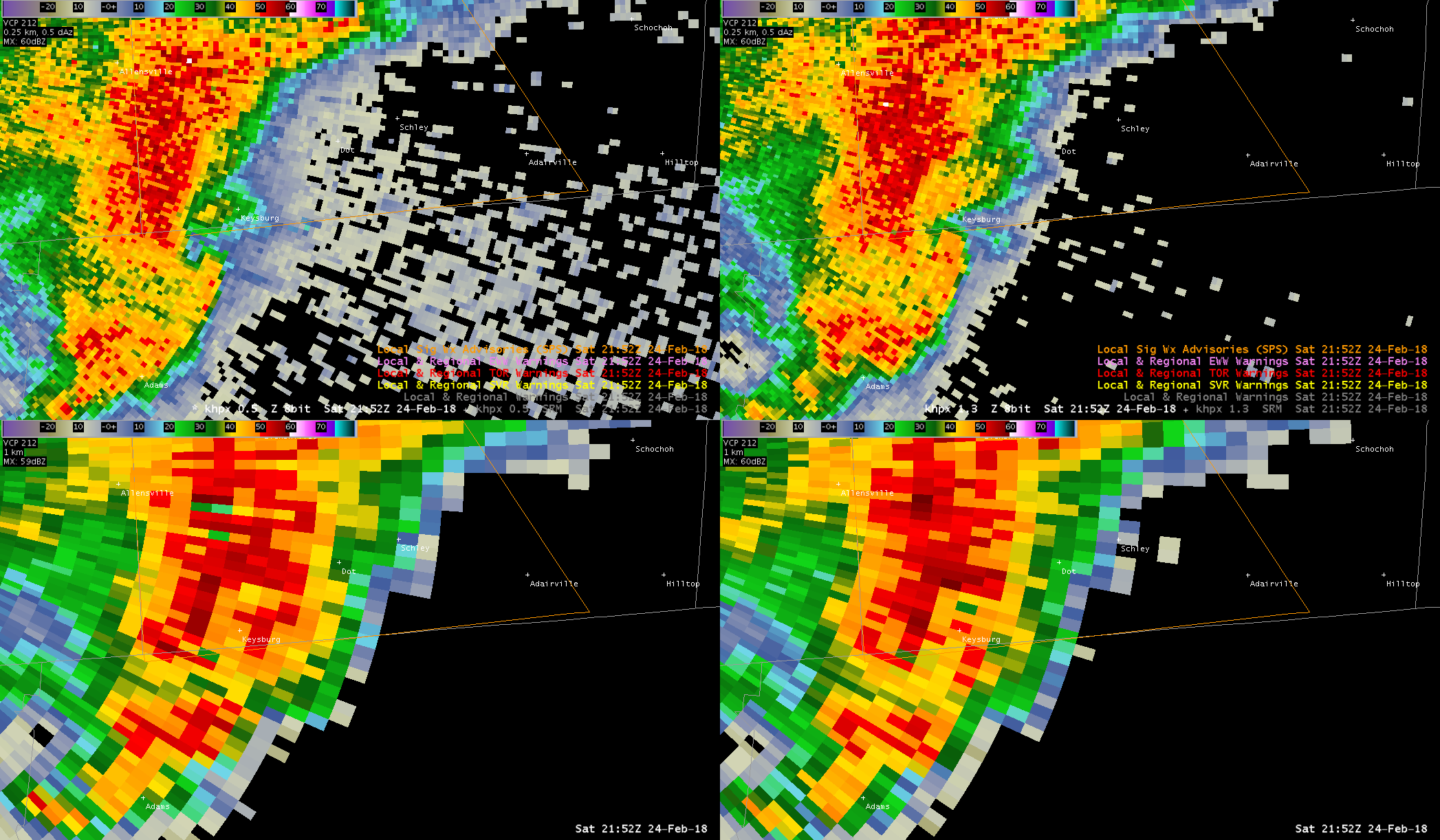
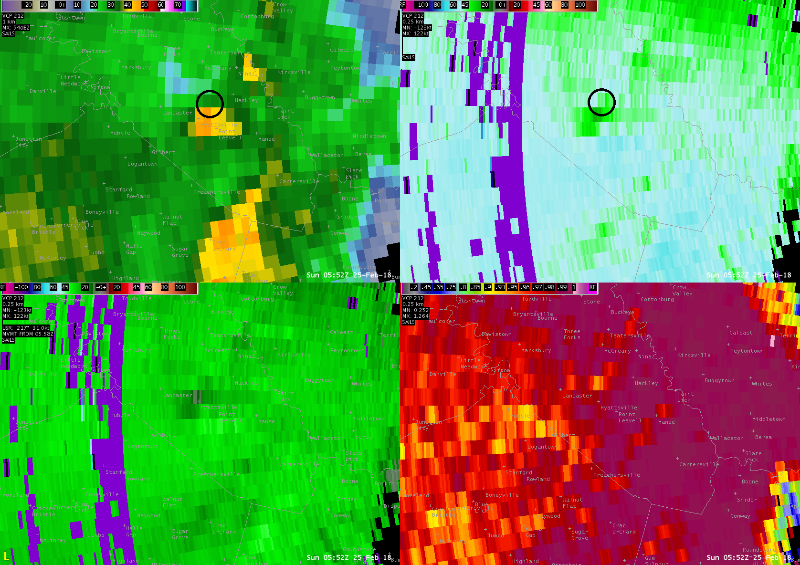
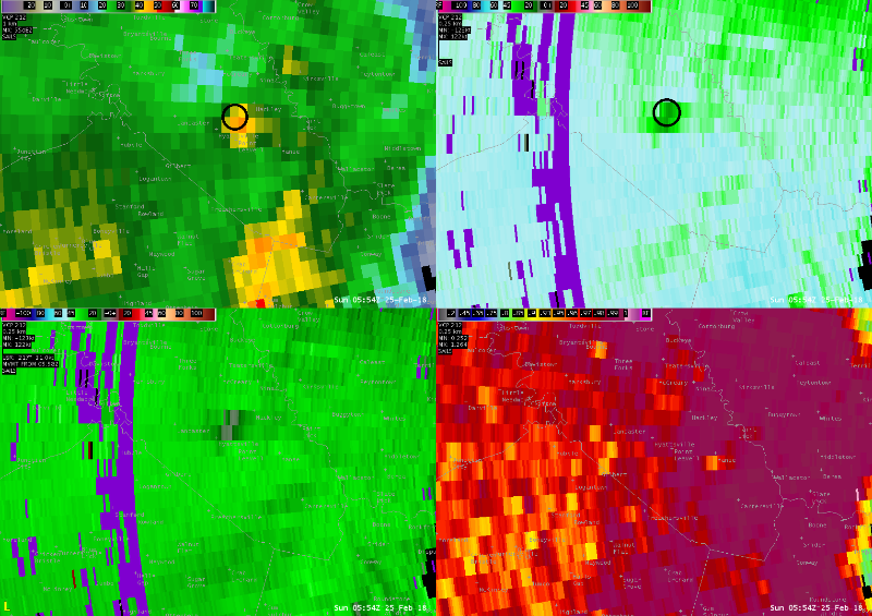
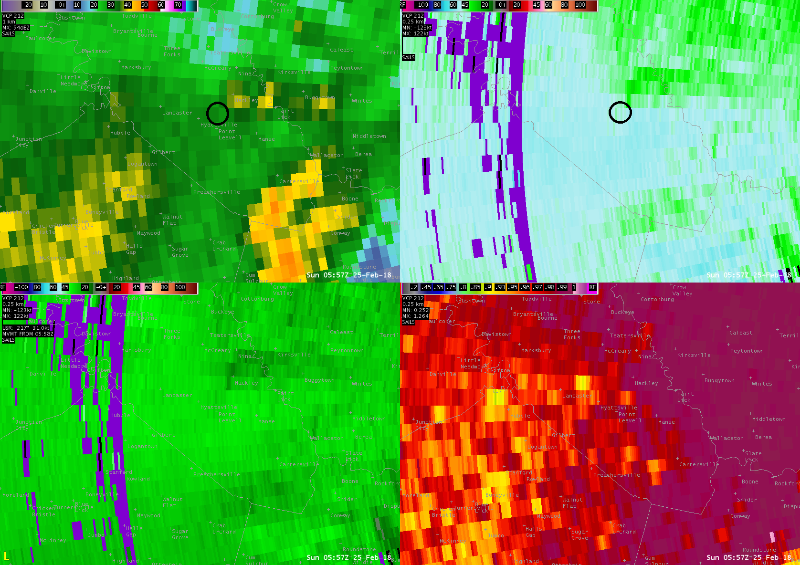
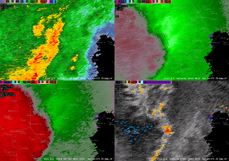
Logan County EF-2
 |
 |
 |
| 5:52pm EST | 5:52pm EST | 5:58pm EST |
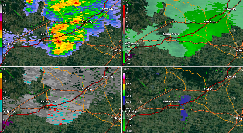
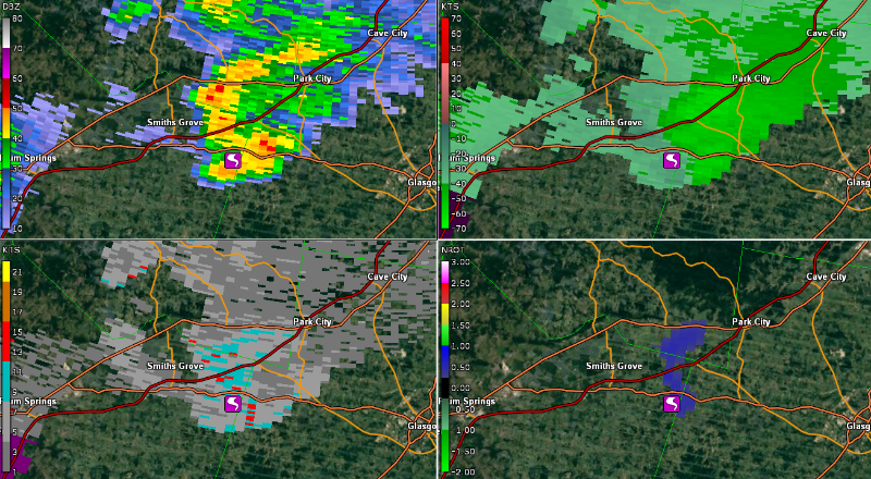
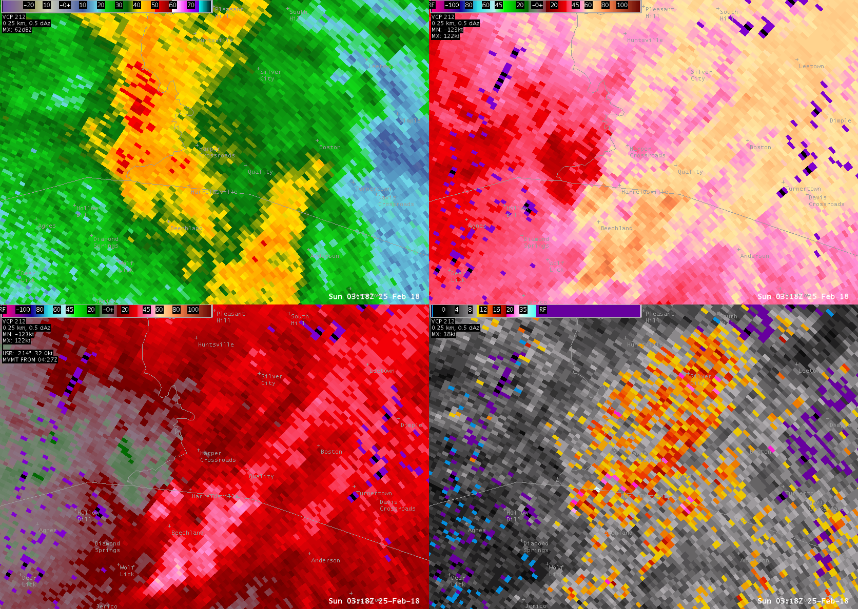
Warren/Barren Counties
 |
 |
 |
| 6:16 PM EST | 6:19 PM EST | 6:22 PM EST |
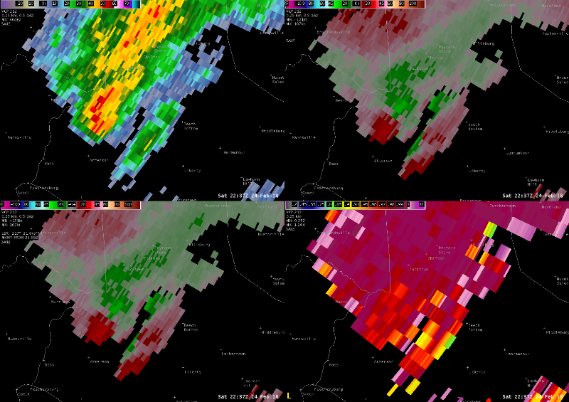
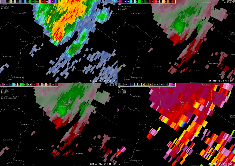
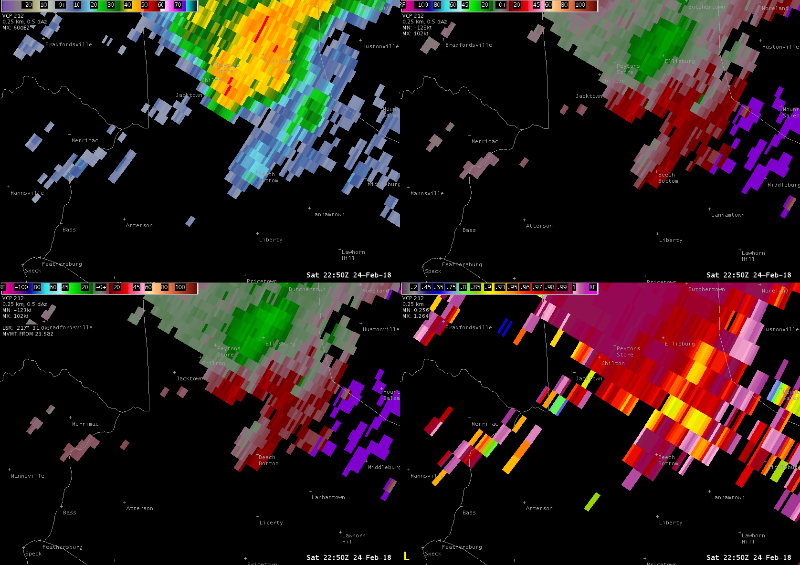
Logan County EF-1
 |
 |
 |
| 10:11pm EST | 10:15pm EST | 10:18pm EST |
Garrard County
 |
 |
 |
| 12:52am EST | 12:54am EST | 12:57am EST |
Butler County
 |
 |
 |
| 10:18pm EST | 10:21pm EST | 10:24pm EST |
Green County
 |
 |
 |
| 10:29pm CST | 10:33pm CST | 10:37pm CST |
Casey County
 |
 |
 |
| 5:37pm EST | 5:45pm EST | 5:50pm EST |
Simpson County
 |
 |
 |
| 10:49pm EST | 10:51pm EST | 10:53pm EST |
Storm Reports
| Sat Feb 24 2018 15:30:00 GMT-0500 (EST) | Butler | 2 NW Quality | KY | TSTM WND DMG | 0 | public | 37.09 | -86.87 | |
| Sat Feb 24 2018 21:00:00 GMT-0500 (EST) | Clark | Utica | IN | FLOOD | 0 | law enforcement | 38.33 | -85.65 | up to 2' of water covering 3rd st. between locust and ash and locust st between 2nd and 3rd. |
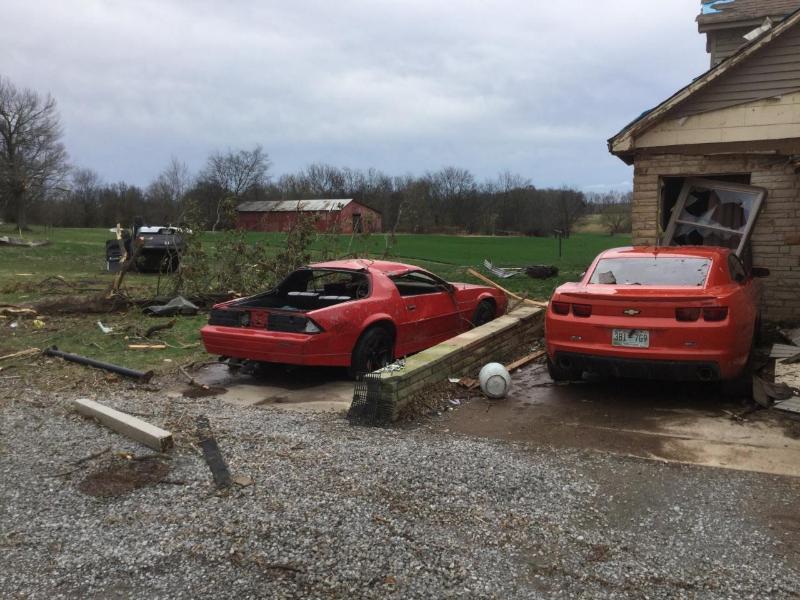
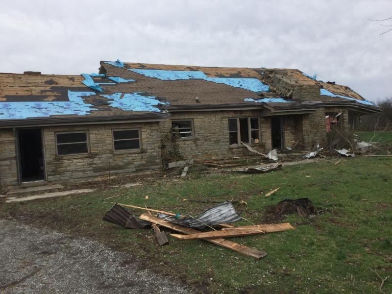
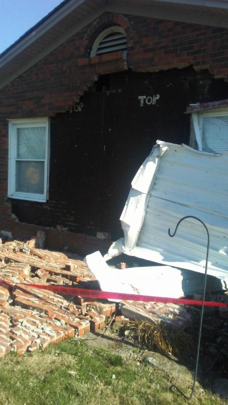
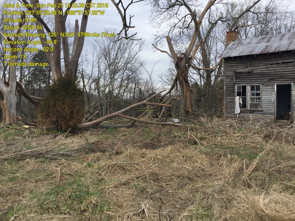
| Sat Feb 24 2018 21:54:00 GMT-0500 (EST) | Logan | 1 S Keysburg | KY | TORNADO | 0 | nws storm survey | 36.64 | -87.01 | *** 1 fatal, 1 inj *** an ef-2 tornado with max winds of 135 mph touched down near the ky/tn state line on mcghee road. the tornado then traveled ne to dot road where 1 fatality and 1 injury occurred at a residence. the tornado continued ne to about 4 miles ne of adairville where it lifted after crossing bores road. the maximum path width was 400 yards, and path length was 11.3 miles. |
| Sat Feb 24 2018 22:00:00 GMT-0500 (EST) | Simpson | 3 SE Franklin | KY | FLOOD | 0 | emergency mngr | 36.7 | -86.54 | *** 1 fatal *** one person drowned in submerged vehicle near flat bridge on kenny perry drive. time estimated. |
| Sat Feb 24 2018 22:05:00 GMT-0500 (EST) | Logan | 1 W Dot | KY | FUNNEL CLOUD | 0 | trained spotter | 36.68 | -86.97 | |
| Sat Feb 24 2018 22:10:00 GMT-0500 (EST) | Logan | 5 SW Corinth | KY | TSTM WND DMG | 0 | trained spotter | 36.74 | -86.85 | trees and power lines down. |
| Sat Feb 24 2018 22:35:00 GMT-0500 (EST) | Casey | 4 SSE Jacktown | KY | TSTM WND DMG | 0 | emergency mngr | 37.4 | -84.99 | trees down, brick home roof damage, camper tossed 6ft -8ft. |
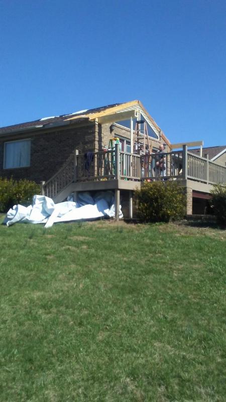
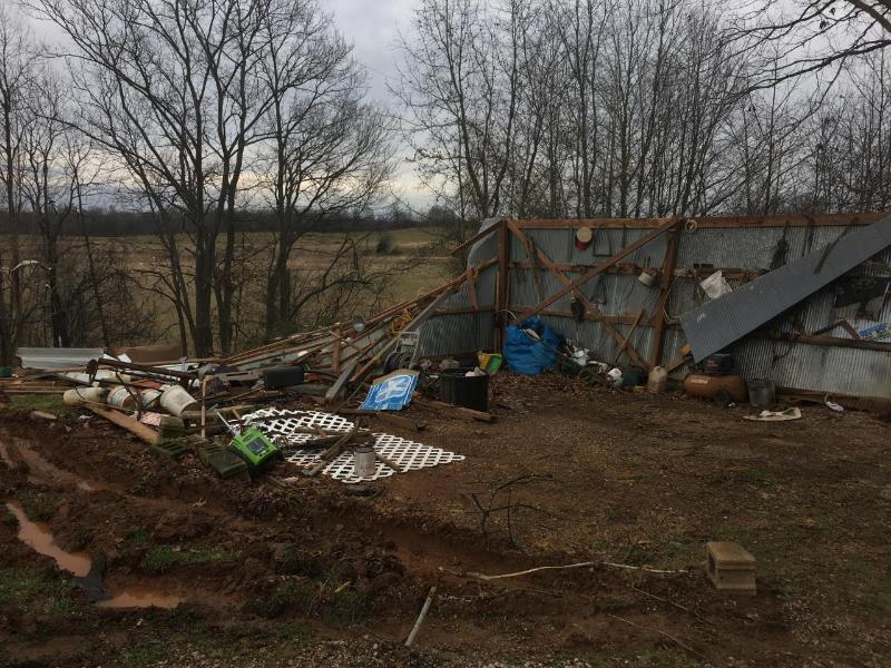
| Sat Feb 24 2018 22:40:00 GMT-0500 (EST) | Casey | 4 SSE Jacktown | KY | TSTM WND DMG | 0 | nws storm survey | 37.4 | -84.99 | nws storm survey found damage consistent of straight line winds in northern casey county. a porch awning was ripped off a home and thrown over the roof into a free standing antenna. a breezeway also had some damage with its ceiling and a door was pushed inward off the frame. downstream, a fifth wheel rv was knocked over, falling into some dirt. part of the house roof ended up downstream a quarter mile, where a forest along a downhill slope showed several trees snapped. |
| Sat Feb 24 2018 23:19:00 GMT-0500 (EST) | Warren | 1 SSW Hays | KY | TORNADO | 0 | nws storm survey | 37.02 | -86.14 | an ef-1 tornado with maximum estimated winds of 100 mph touched down on hays pondsville road about 1 mile ssw of hays. the tornado then traveled ne just across the warren/barren county line where it lifted after damaging a barn. the total path length was approximately 2.25 miles with a max width of 30 yards. the duration of the tornado event was 2 minutes. |
| Sat Feb 24 2018 23:20:00 GMT-0500 (EST) | Barren | 1 NE Hays | KY | TSTM WND DMG | 0 | 911 call center | 37.04 | -86.12 | reported at 2911 lewis road, smiths grove, ky trees down and structural damage. |
| Sat Feb 24 2018 23:30:00 GMT-0500 (EST) | Jefferson | 1 SSE Anchorage | KY | FLASH FLOOD | 0 | amateur radio | 38.26 | -85.53 | numerous reports of flooded roadways across much of the louisville metro area including water rescues in the anchorage area. manhole covers reported off in the downtown area. |
| Sat Feb 24 2018 23:40:00 GMT-0500 (EST) | Jefferson | 1 E Okolona | KY | FLOOD | 0 | public | 38.14 | -85.67 | high water, roads closed, vehicles stranded. |
| Sat Feb 24 2018 23:45:00 GMT-0500 (EST) | Jefferson | 3 WNW Louisville | KY | FLASH FLOOD | 0 | public | 38.27 | -85.81 | |
| Sat Feb 24 2018 23:59:00 GMT-0500 (EST) | Jefferson | 2 NNW Jeffersontown | KY | FLASH FLOOD | 0 | amateur radio | 38.23 | -85.58 | cars stranded. water up 4 ft on the road. |
| Sun Feb 25 2018 00:01:00 GMT-0500 (EST) | Jefferson | 2 E Louisville | KY | FLASH FLOOD | 0 | amateur radio | 38.26 | -85.72 | exit ramps being closed due to high water. i64 and story ave. |
| Sun Feb 25 2018 00:10:00 GMT-0500 (EST) | Jefferson | 4 ESE Middletown | KY | TSTM WND DMG | 0 | public | 38.22 | -85.46 | trees down. |
| Sun Feb 25 2018 00:10:00 GMT-0500 (EST) | Jefferson | 4 ESE Middletown | KY | TSTM WND DMG | 0 | amateur radio | 38.22 | -85.46 | corrects previous tstm wnd dmg report from 4 ese middletown. trees down. |
| Sun Feb 25 2018 00:17:00 GMT-0500 (EST) | Jefferson | 2 SSW Fairdale | KY | FLASH FLOOD | 0 | amateur radio | 38.09 | -85.77 | fairdale fire dept says intersection of mitchell rd and holsclaw rd impassable. |
| Sun Feb 25 2018 00:19:00 GMT-0500 (EST) | Jefferson | 2 NNW Jeffersontown | KY | FLASH FLOOD | 0 | law enforcement | 38.23 | -85.58 | water rescues. |
| Sun Feb 25 2018 00:45:00 GMT-0500 (EST) | Oldham | 2 SSE Buckner | KY | HEAVY RAIN | 2.9 | nws employee | 38.36 | -85.42 | 2.9 inches measured since 7 am est. |
| Sun Feb 25 2018 00:51:00 GMT-0500 (EST) | Jefferson | 1 NW Anchorage | KY | FLASH FLOOD | 0 | amateur radio | 38.28 | -85.55 | water rescue on the intersection of nutwood rd and evergreen rd. |
| Sun Feb 25 2018 01:00:00 GMT-0500 (EST) | Jefferson | 1 SSE Lyndon | KY | FLASH FLOOD | 0 | broadcast media | 38.25 | -85.58 | shelbyville rd and hurstbourne pkwy intersection. right lane flooded, car submerged. |
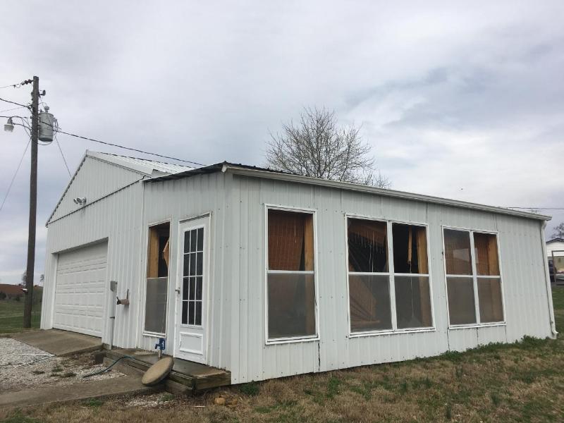
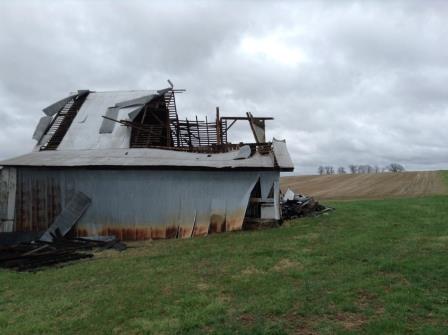
| Sun Feb 25 2018 01:03:00 GMT-0500 (EST) | Edmonson | 1 S Rhoda | KY | TSTM WND DMG | 0 | nws storm survey | 37.13 | -86.23 | the survey crew observed intermittent straight-line wind damage in the town of chalybeate. there was damage to fences, several trees snapped, and 2 older barns experienced significant damage. in a residential area, two large sections of trees fell on one roof, and an above ground swimming pool was blown away. everything was facing down from west to east, indicative of straight-line wind damage. the duration of the tstm wnd dmg event was 2 minutes. |
| Sun Feb 25 2018 01:10:00 GMT-0500 (EST) | Oldham | 1 WNW Pewee Valley | KY | HEAVY RAIN | 3.57 | nws employee | 38.32 | -85.5 | reported at 106 rollington rd, pewee valley , ky 3.57 inches since 7 am est. |
| Sun Feb 25 2018 02:17:00 GMT-0500 (EST) | Oldham | 3 ENE La Grange | KY | FLASH FLOOD | 0 | broadcast media | 38.42 | -85.33 | i-71 closed both directions due to flooding in oldham county. |
| Sun Feb 25 2018 02:23:00 GMT-0500 (EST) | Bullitt | 5 ENE West Point | KY | FLASH FLOOD | 0 | broadcast media | 38.01 | -85.86 | bullitt county ky 1526 has been closed between mile marker 1 and 2 (near ky 44) due to a mudslide. |
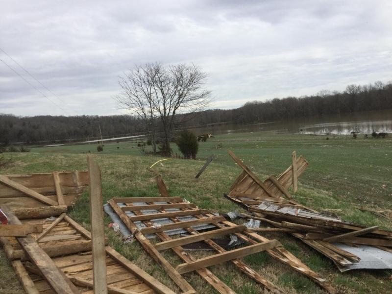
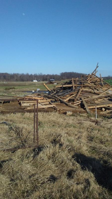
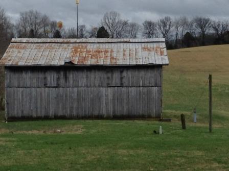
| Sun Feb 25 2018 02:35:00 GMT-0500 (EST) | Simpson | 4 SSW Franklin | KY | TORNADO | 0 | nws storm survey | 36.67 | -86.59 | the tornado began just southwest of lake spring road where a couple of trees were snapped or uprooted and a large 24 x 36 barn experienced extensive roof panel damage. maximum winds were estimated at 80 mph with a width between 75 and 100 yards. the tornado continued to cross farmland before striking another barn near the 31w intersection. the tornado threw metal sheeting from the barn in various directions with much of it suspended up in the trees. there were a couple twisted trees on both sides of highway 31w. maximum winds at this location were 75 mph with a width of 75 yards. the tornado lifted on the northeast side of the highway. |
| Sun Feb 25 2018 02:36:00 GMT-0500 (EST) | Clark | 1 N Henryville | IN | FLASH FLOOD | 0 | public | 38.54 | -85.77 | street flooding. us 31 near intersection of indiana 160 in henryville, in. |
| Sun Feb 25 2018 02:41:00 GMT-0500 (EST) | Trimble | 3 NNE Sligo | KY | FLASH FLOOD | 0 | dept of highways | 38.53 | -85.3 | delayed report...water over the road in several places on ky 3175...sulphur-bedford rd. |
| Sun Feb 25 2018 02:45:00 GMT-0500 (EST) | Bullitt | 1 E Shepherdsville | KY | FLASH FLOOD | 0 | public | 37.99 | -85.7 | salt river, under i-65 bridge. park signs nearly under water. |
| Sun Feb 25 2018 02:45:00 GMT-0500 (EST) | Dubois | Huntingburg | IN | FLASH FLOOD | 0 | 911 call center | 38.3 | -86.95 | delayed report. numerous roads closed due to high water. 32 roads closed in dubois county at one time. |
| Sun Feb 25 2018 02:50:00 GMT-0500 (EST) | Bullitt | 5 S Valley Station | KY | FLASH FLOOD | 0 | public | 38.04 | -85.86 | portion of the road washed out on weavers run road. |
| Sun Feb 25 2018 03:08:00 GMT-0500 (EST) | Scott | Scottsburg | IN | FLASH FLOOD | 0 | public | 38.69 | -85.78 | flash flooding on us 31 n just north of indiana 56 and east of i-65. |
| Sun Feb 25 2018 03:15:00 GMT-0500 (EST) | Logan | 4 N Lewisburg | KY | TSTM WND DMG | 0 | nws storm survey | 37.04 | -86.95 | a tree was blown across coon range lake road. |
| Sun Feb 25 2018 03:15:00 GMT-0500 (EST) | Logan | 2 NNW Lewisburg | KY | TORNADO | 0 | nws storm survey | 37.02 | -86.97 | an ef-1 tornado with max winds of 110 mph touched down near elamon road about 2 miles nnw of lewisburg. it then traveled ese across lewisburg road before lifting. the total path length was approximately 1 mile, and the tornado was on the ground for 1 minute. |
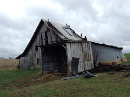
| Sun Feb 25 2018 03:21:00 GMT-0500 (EST) | Butler | 2 N Quality | KY | TSTM WND DMG | 0 | nws storm survey | 37.1 | -86.85 | a barn was damaged and a large tree was uprooted along huntsville-quality road. |
| Sun Feb 25 2018 03:21:00 GMT-0500 (EST) | Butler | 2 NW Quality | KY | TORNADO | 0 | nws storm survey | 37.09 | -86.87 | the damage began near ewing road where trees were snapped and twisted. this continued along graveltown road where more trees were twisted and snapped and couple were uprooted. wind speeds averaged 90 mph with a width of 75 to 100 yards. the tornado reached its peak intensity on highway 106 where it did significant damage to a large barn. wind speeds increased to 95 mph with a width of 100 yards. the tornado crossed highway 106 uprooting 2 trees and then lifted 200 yards past the highway. the duration of the tornado event was 3 minutes. |
| Sun Feb 25 2018 03:30:00 GMT-0500 (EST) | Jefferson | 4 NNE Okolona | KY | FLASH FLOOD | 0 | amateur radio | 38.19 | -85.66 | fire department rescuing residents due to flash flooding. |
| Sun Feb 25 2018 03:38:00 GMT-0500 (EST) | Jefferson | 1 SW Lyndon | KY | FLASH FLOOD | 0 | amateur radio | 38.25 | -85.6 | entrance to apartment complex flooded. |
| Sun Feb 25 2018 03:38:00 GMT-0500 (EST) | Warren | 2 NW Rockfield | KY | TSTM WND DMG | 0 | trained spotter | 36.92 | -86.57 | tree down. |
| Sun Feb 25 2018 03:38:00 GMT-0500 (EST) | Warren | 1 NNW Bowling Green | KY | TSTM WND DMG | 0 | public | 36.99 | -86.45 | tree down on power line, corner of cabell dr and chestnut st. |
| Sun Feb 25 2018 03:43:00 GMT-0500 (EST) | Warren | Bowling Green | KY | TSTM WND GST | 69 | public | 36.98 | -86.46 | |
| Sun Feb 25 2018 03:44:00 GMT-0500 (EST) | Warren | 1 SE Bowling Green | KY | TSTM WND GST | 58 | asos | 36.96 | -86.43 | peak wind gust at bowling green regional airport. |
| Sun Feb 25 2018 03:45:00 GMT-0500 (EST) | Warren | 2 ENE Bowling Green | KY | TSTM WND DMG | 0 | public | 36.98 | -86.4 | report of tree blocking 2100 block of mount victor lane. |
| Sun Feb 25 2018 03:54:00 GMT-0500 (EST) | Edmonson | 3 ENE Rhoda | KY | TSTM WND DMG | 0 | public | 37.17 | -86.18 | reported at hwy 70 near mammoth cave national park tree down blocking hwy 70 on both sides. |
| Sun Feb 25 2018 03:55:00 GMT-0500 (EST) | Jefferson | 1 SSW Fairdale | KY | FLASH FLOOD | 0 | amateur radio | 38.1 | -85.76 | significant flash flooding reported on mitchell hill rd, in the holly hills subdivision. |
| Sun Feb 25 2018 03:56:00 GMT-0500 (EST) | Bullitt | 5 S Valley Station | KY | TSTM WND DMG | 0 | nws employee | 38.04 | -85.86 | delayed report. trees down on weavers run rd. part of road washed out. |
| Sun Feb 25 2018 04:00:00 GMT-0500 (EST) | Hancock | 1 W Hawesville | KY | FLASH FLOOD | 0 | 911 call center | 37.9 | -86.77 | delayed report. numerous roads across county experienced high water and flood. |
| Sun Feb 25 2018 04:04:00 GMT-0500 (EST) | Warren | 1 N Bowling Green | KY | LIGHTNING | 0 | broadcast media | 36.99 | -86.44 | reports of roof on fire at steamers seafood in downtown bowling green. possible lightning strike. |
| Sun Feb 25 2018 04:10:00 GMT-0500 (EST) | Barren | Glasgow | KY | TSTM WND GST | 47 | awos | 37.03 | -85.95 | awos station glw, glasgow. |
| Sun Feb 25 2018 04:12:00 GMT-0500 (EST) | Jefferson | 2 E Saint Matthews | KY | FLASH FLOOD | 0 | broadcast media | 38.25 | -85.61 | shelbyville rd near oxmoor. water rescues in progress. |
| Sun Feb 25 2018 04:13:00 GMT-0500 (EST) | Jefferson | 3 S Saint Matthews | KY | HEAVY RAIN | 4.04 | broadcast media | 38.21 | -85.64 | klondike elementary school measured 4.04 inches of rain so far today. |
| Sun Feb 25 2018 04:20:00 GMT-0500 (EST) | Shelby | 2 S Eminence | KY | TSTM WND GST | 43 | mesonet | 38.33 | -85.17 | mesonet station crop, 2 s eminence. |
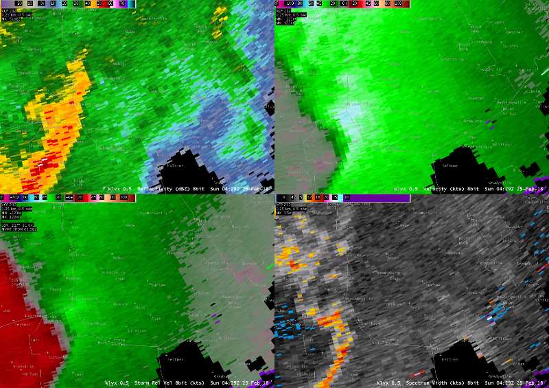
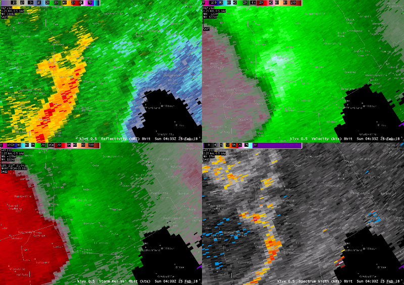
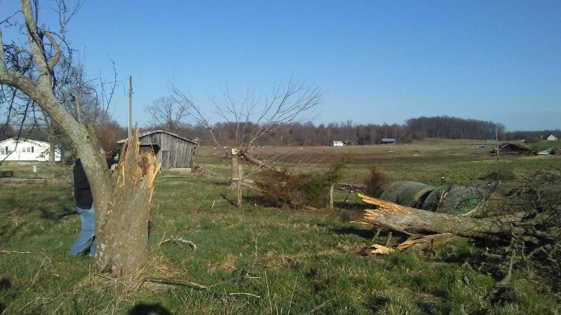
| Sun Feb 25 2018 04:33:00 GMT-0500 (EST) | Green | 3 N Pierce | KY | TORNADO | 0 | nws storm survey | 37.23 | -85.62 | an ef2 tornado with 110-115 mph peak winds touched down in green county ky near the town of grab. it damaged and downed multiple barns and snapped trees along its path. it also damaged several houses. |
| Sun Feb 25 2018 04:41:00 GMT-0500 (EST) | Hardin | 2 W Elizabethtown | KY | FLASH FLOOD | 0 | public | 37.7 | -85.91 | corrects previous flash flood report from 2 w elizabethtown. road flooding off ring rd. |
| Sun Feb 25 2018 04:45:00 GMT-0500 (EST) | Hart | 1 ENE Hardyville | KY | TSTM WND GST | 38 | mesonet | 37.26 | -85.78 | mesonet station hdyv, 1 ene hardyville. |
| Sun Feb 25 2018 04:49:00 GMT-0500 (EST) | Crawford | 1 NNW English | IN | FLASH FLOOD | 0 | county official | 38.34 | -86.47 | hwy 37 , english at sr 64 is under water, as well as several streets in marengo, crawford county. |
| Sun Feb 25 2018 04:57:00 GMT-0500 (EST) | Jefferson | 2 NNW Okolona | KY | FLASH FLOOD | 0 | public | 38.17 | -85.71 | widespread flooding with cars floating in the draining ditches near west indian trail near the pnc bank. |
| Sun Feb 25 2018 04:57:00 GMT-0500 (EST) | Green | 3 W Greensburg | KY | TSTM WND DMG | 0 | broadcast media | 37.26 | -85.55 | reported at green county, ky power outages and trees down county wide. |
| Sun Feb 25 2018 04:59:00 GMT-0500 (EST) | Jefferson | 2 SSW Lyndon | KY | FLASH FLOOD | 0 | public | 38.24 | -85.6 | water over roadway in oxmoor woods subdivision. |
| Sun Feb 25 2018 05:03:00 GMT-0500 (EST) | Green | 3 NNE Pierce | KY | TSTM WND DMG | 0 | emergency mngr | 37.23 | -85.6 | several trees and power lines down along grab rd, southwest of greensburg. |
| Sun Feb 25 2018 05:05:00 GMT-0500 (EST) | Jefferson | 1 NE Fairdale | KY | FLASH FLOOD | 0 | amateur radio | 38.12 | -85.75 | flooded street at national turnpike and gene snyder. |
| Sun Feb 25 2018 05:05:00 GMT-0500 (EST) | Harrison | 2 ESE Berry | KY | TSTM WND GST | 48 | mesonet | 38.5 | -84.35 | mesonet station rbsn, 2 ese berry. |
| Sun Feb 25 2018 05:07:00 GMT-0500 (EST) | Clark | 1 SSW Speed | IN | FLASH FLOOD | 0 | broadcast media | 38.41 | -85.75 | reported at north indiana ave, sellersburg, in water rescue in progress. |
| Sun Feb 25 2018 05:25:00 GMT-0500 (EST) | Jefferson | 2 NNW Okolona | KY | FLASH FLOOD | 0 | broadcast media | 38.17 | -85.71 | reported at 5500 preston hwy, louisville, ky 40219 reports of cars floating in the flood waters at west indian trail in okalona near pnc bank. |
| Sun Feb 25 2018 05:30:00 GMT-0500 (EST) | Oldham | 1 WNW Goshen | KY | FLASH FLOOD | 0 | dept of highways | 38.41 | -85.61 | delayed report. hwy 3222 flooded. other numerous roads experienced high water. |
| Sun Feb 25 2018 05:50:00 GMT-0500 (EST) | Garrard | 3 WNW Paint Lick | KY | TORNADO | 0 | nws storm survey | 37.63 | -84.47 | corrects previous tornado report from 3 wnw paint lick. a small and brief ef1 tornado touched down on the ridge of gillespie pike east of lancaster. the tornado first uprooted a tree, then came to a small shed, which it shifted off its foundation into a fence. the main property for that shed then had a loss of roof covering as well as impact from debris. another outbuilding was overturned and slid about 10 feet. the tornado then crossed the street, where a brick veneer home lost part of its outer wall, as it was struck by debris, as well as some roof damage. a couple of columns on the porch fell. the adjoining garage lost its roof and doors were bent inward, falling onto the vehicles inside. a barn behind the house collapsed and another outbuilding completely lost its walls, but the contents were not disturbed. this is the point where the tornado lifted. thanks to garrard county and kentucky emergency management for assisting with the survey. the duration of the tornado event was 1 minute. |
| Sun Feb 25 2018 06:07:00 GMT-0500 (EST) | Franklin | 1 WNW Forks Of Elkhorn | KY | HEAVY RAIN | 1.49 | public | 38.22 | -84.83 | |
| Sun Feb 25 2018 06:50:00 GMT-0500 (EST) | Garrard | 3 WNW Paint Lick | KY | TORNADO | 0 | nws storm survey | 37.63 | -84.47 | a small and brief ef1 tornado touched down on the ridge of gillespie pike east of lancaster. the tornado first uprooted a tree, then came to a small shed, which it shifted off its foundation into a fence. the main property for that shed then had a loss of roof covering as well as impact from debris. another outbuilding was overturned and slid about 10 feet. the tornado then crossed the street, where a brick veneer home lost part of its outer wall, as it was struck by debris, as well as some roof damage. a couple of columns on the porch fell. the adjoining garage lost its roof and doors were bent inward, falling onto the vehicles inside. a barn behind the house collapsed and another outbuilding completely lost its walls, but the contents were not disturbed. this is the point where the tornado lifted. thanks to garrard county and kentucky emergency management for assisting with the survey. the duration of the tornado event was 1 minute. |
| Sun Feb 25 2018 09:40:00 GMT-0500 (EST) | Jefferson | 1 NNW Pleasure Ridge Pa | KY | HEAVY RAIN | 2.18 | cocorahs | 38.16 | -85.86 | 24-hour total. 6.97" 5-day total. |
| Sun Feb 25 2018 10:00:00 GMT-0500 (EST) | Oldham | 2 SSW Buckner | KY | HEAVY RAIN | 4.65 | cocorahs | 38.36 | -85.45 | 24-hour total. 8.93" 5-day total. |
| Sun Feb 25 2018 11:00:00 GMT-0500 (EST) | Floyd | 2 W Floyds Knobs | IN | HEAVY RAIN | 2.89 | cocorahs | 38.32 | -85.9 | 24-hour total. 7.96" 5-day total. |
| Sun Feb 25 2018 11:00:00 GMT-0500 (EST) | Dubois | Huntingburg | IN | HEAVY RAIN | 3.04 | cocorahs | 38.29 | -86.96 | 24-hour total. 6.28" 5-day total. |
| Sun Feb 25 2018 11:00:00 GMT-0500 (EST) | Logan | 3 SSW Auburn | KY | HEAVY RAIN | 2.24 | cocorahs | 36.83 | -86.72 | 24-hour total. 5.59" 5-day total. |
| Sun Feb 25 2018 11:00:00 GMT-0500 (EST) | Clark | 1 NW Jeffersonville | IN | HEAVY RAIN | 2.42 | cocorahs | 38.31 | -85.74 | 24-hour total. 7.64" 5-day total. |
| Sun Feb 25 2018 11:00:00 GMT-0500 (EST) | Scott | 1 WSW Austin | IN | HEAVY RAIN | 2.41 | cocorahs | 38.74 | -85.83 | 24-hour total. 4.89" 5-day total. |
| Sun Feb 25 2018 11:30:00 GMT-0500 (EST) | Washington | 1 NNW Martinsburg | IN | HEAVY RAIN | 2.74 | cocorahs | 38.46 | -86.04 | 24-hour total. |
| Sun Feb 25 2018 12:00:00 GMT-0500 (EST) | Oldham | 1 WNW Pewee Valley | KY | HEAVY RAIN | 5.01 | nws employee | 38.32 | -85.5 | 24-hour rainfall total. 5-day total 9.26". |
| Sun Feb 25 2018 12:00:00 GMT-0500 (EST) | Oldham | 2 SSE Buckner | KY | HEAVY RAIN | 4.23 | nws employee | 38.36 | -85.42 | 24-hour total. 8.15" 5-day total. |
| Sun Feb 25 2018 12:00:00 GMT-0500 (EST) | Oldham | 2 NNE La Grange | KY | HEAVY RAIN | 4.05 | cocorahs | 38.43 | -85.36 | 24-hour total. 8.32" 5-day total. |
| Sun Feb 25 2018 12:00:00 GMT-0500 (EST) | Jefferson | 1 SW Pewee Valley | KY | HEAVY RAIN | 4.36 | cocorahs | 38.3 | -85.5 | 24-hour rainfall total. 8.24" 5-day total. |
| Sun Feb 25 2018 12:00:00 GMT-0500 (EST) | Jefferson | 3 NW Anchorage | KY | HEAVY RAIN | 3.39 | cocorahs | 38.3 | -85.57 | 24-hour total. 7.63" 5-day total. |
| Sun Feb 25 2018 12:00:00 GMT-0500 (EST) | Jefferson | 1 WSW Saint Matthews | KY | HEAVY RAIN | 2.99 | cocorahs | 38.24 | -85.66 | 24-hour total. 7.15" 5-day total. |
| Sun Feb 25 2018 12:00:00 GMT-0500 (EST) | Henry | 3 WNW Smithfield | KY | HEAVY RAIN | 2.81 | cocorahs | 38.4 | -85.3 | 24-hour total. 6.58" 5-day total. |
| Sun Feb 25 2018 12:00:00 GMT-0500 (EST) | Jefferson | 4 SE Pewee Valley | KY | HEAVY RAIN | 2.42 | cocorahs | 38.27 | -85.44 | 24-hour total. 6.01" 5-day total. |
| Sun Feb 25 2018 12:00:00 GMT-0500 (EST) | Trimble | 2 W Milton | KY | HEAVY RAIN | 2.67 | cocorahs | 38.71 | -85.41 | 24-hour total. 5.98" 5-day total. |
| Sun Feb 25 2018 12:00:00 GMT-0500 (EST) | Jefferson | 3 E Shively | KY | HEAVY RAIN | 2.38 | cocorahs | 38.2 | -85.76 | 24-hour total. 6.41" 5-day total. |
| Sun Feb 25 2018 12:00:00 GMT-0500 (EST) | Crawford | 1 ENE Curby | IN | HEAVY RAIN | 2.66 | cocorahs | 38.24 | -86.37 | 24-hour total. 6.98" 5-day total. |
| Sun Feb 25 2018 12:00:00 GMT-0500 (EST) | Harrison | 1 ESE Corydon | IN | HEAVY RAIN | 2.6 | cocorahs | 38.21 | -86.11 | 24-hour total. |
| Sun Feb 25 2018 12:00:00 GMT-0500 (EST) | Harrison | 2 N White Cloud | IN | HEAVY RAIN | 2.46 | cocorahs | 38.27 | -86.23 | 24-hour total. 6.51" 5-day total. |
| Sun Feb 25 2018 12:00:00 GMT-0500 (EST) | Clark | 2 NNE Henryville | IN | HEAVY RAIN | 2.69 | cocorahs | 38.56 | -85.75 | 24-hour total. 6.48" 5-day total. |
| Sun Feb 25 2018 12:00:00 GMT-0500 (EST) | Perry | 4 NNE Dodd | IN | HEAVY RAIN | 2.3 | cocorahs | 37.98 | -86.65 | 24-hour total. 7.2" 5-day total. |
| Sun Feb 25 2018 12:00:00 GMT-0500 (EST) | Jefferson | 1 S Hanover | IN | HEAVY RAIN | 2.18 | cocorahs | 38.7 | -85.47 | 24-hour total. 5.43" 5-day total. |
| Sun Feb 25 2018 12:00:00 GMT-0500 (EST) | Jefferson | 3 SE Jeffersontown | KY | HEAVY RAIN | 2.31 | cocorahs | 38.18 | -85.54 | 24-hour total. 5.77" 5-day total. |
| Sun Feb 25 2018 12:00:00 GMT-0500 (EST) | Bullitt | 1 S Brooks | KY | HEAVY RAIN | 2.08 | cocorahs | 38.05 | -85.72 | 24-hour total. 6.11" 5-day total. |
| Sun Feb 25 2018 12:00:00 GMT-0500 (EST) | Henry | 1 SE Eminence | KY | HEAVY RAIN | 2.03 | cocorahs | 38.35 | -85.16 | 24-hour total. 5.05" 5-day total. |
| Sun Feb 25 2018 12:00:00 GMT-0500 (EST) | Logan | Auburn | KY | HEAVY RAIN | 2.03 | cocorahs | 36.86 | -86.7 | 24-hour total. 5.60" 5-day total. |
| Sun Feb 25 2018 12:00:00 GMT-0500 (EST) | Washington | Organ Springs | IN | HEAVY RAIN | 2.38 | cocorahs | 38.48 | -86.16 | 24-hour total. 5.61" 5-day total. |
| Sun Feb 25 2018 12:00:00 GMT-0500 (EST) | Washington | 2 SSE Salem | IN | HEAVY RAIN | 2.25 | cocorahs | 38.57 | -86.08 | 24-hour total. 5.22" 5-day total. |
| Sun Feb 25 2018 12:00:00 GMT-0500 (EST) | Harrison | 1 N Elizabeth | IN | HEAVY RAIN | 2.16 | cocorahs | 38.15 | -85.97 | 24-hour total. 7.31" 5-day total. |
| Sun Feb 25 2018 12:00:00 GMT-0500 (EST) | Floyd | 2 NW Floyds Knobs | IN | HEAVY RAIN | 2.88 | cocorahs | 38.33 | -85.89 | 24-hour total. 7.88" 5-day total. |
| Sun Feb 25 2018 12:00:00 GMT-0500 (EST) | Harrison | 2 W Dogwood | IN | HEAVY RAIN | 2.12 | co-op observer | 38.1 | -86.11 | 24-hour total. 5.98" 5-day total. |
| Sun Feb 25 2018 12:00:00 GMT-0500 (EST) | Breckinridge | 3 WSW Big Spring | KY | HEAVY RAIN | 2.97 | co-op observer | 37.79 | -86.23 | 24-hour total. 7.71" 5-day total. |
| Sun Feb 25 2018 12:00:00 GMT-0500 (EST) | Jefferson | 2 SSW Highview | KY | HEAVY RAIN | 2.05 | official nws obs | 38.11 | -85.65 | 24-hour total. 5.77" 5-day total. |
| Sun Feb 25 2018 12:00:00 GMT-0500 (EST) | Jefferson | 1 ESE Lyndon | KY | HEAVY RAIN | 4.45 | nws employee | 38.26 | -85.57 | from saturday afternoon through early this morning. 5-day total of 8.65". |
| Sun Feb 25 2018 12:18:00 GMT-0500 (EST) | Crawford | 1 ESE West Fork | IN | HEAVY RAIN | 2.2 | cocorahs | 38.23 | -86.52 | 24-hour total. 6.04" 5-day total. |
| Sun Feb 25 2018 12:20:00 GMT-0500 (EST) | Washington | 1 N Mckinley | IN | HEAVY RAIN | 2.31 | public | 38.76 | -86.2 | 24-hour total. |
| Sun Feb 25 2018 12:45:00 GMT-0500 (EST) | Henry | 1 SSE Campbellsburg | KY | HEAVY RAIN | 3.06 | cocorahs | 38.52 | -85.2 | 24-hour total. 6.72" 5-day total. |
| Sun Feb 25 2018 13:00:00 GMT-0500 (EST) | Trimble | 4 NNW Bedford | KY | HEAVY RAIN | 2.84 | cocorahs | 38.65 | -85.35 | 24-hour total. 6.61" 5-day total. |
| Sun Feb 25 2018 13:00:00 GMT-0500 (EST) | Hancock | 3 E Lewisport | KY | HEAVY RAIN | 2.48 | cocorahs | 37.93 | -86.85 | 24-hour total. |
| Sun Feb 25 2018 13:00:00 GMT-0500 (EST) | Floyd | 2 SW Hamburg | IN | HEAVY RAIN | 3.08 | cocorahs | 38.37 | -85.79 | 24-hour total. 7.26" 5-day total. |
| Sun Feb 25 2018 13:00:00 GMT-0500 (EST) | Crawford | Beechwood | IN | HEAVY RAIN | 2.25 | co-op observer | 38.2 | -86.42 | 24-hour total. 6.12" 5-day total. |
| Sun Feb 25 2018 13:00:00 GMT-0500 (EST) | Shelby | 2 NW Chestnut Grove | KY | HEAVY RAIN | 2.3 | cocorahs | 38.32 | -85.28 | 24-hour total. 6.12" 5-day total. |
| Sun Feb 25 2018 13:00:00 GMT-0500 (EST) | Floyd | 3 WSW Saint Joseph | IN | HEAVY RAIN | 2.46 | cocorahs | 38.37 | -85.87 | 24-hour total. 6.87" 5-day total. |
| Sun Feb 25 2018 13:00:00 GMT-0500 (EST) | Harrison | 1 WNW New Salisbury | IN | HEAVY RAIN | 2.17 | cocorahs | 38.32 | -86.12 | 24-hour total. 6.46" 5-day total. |
| Sun Feb 25 2018 13:00:00 GMT-0500 (EST) | Henry | 2 NE Smithfield | KY | HEAVY RAIN | 2.56 | cocorahs | 38.41 | -85.23 | 24-hour total. 6.17" 5-day total. |
| Sun Feb 25 2018 13:00:00 GMT-0500 (EST) | Crawford | Leavenworth | IN | HEAVY RAIN | 2.74 | co-op observer | 38.2 | -86.35 | 24-hour total. 7.03" 5-day total. |
| Sun Feb 25 2018 13:00:00 GMT-0500 (EST) | Jefferson | 1 NNW Louisville | KY | HEAVY RAIN | 2.1 | co-op observer | 38.26 | -85.77 | 24-hour total. 7.05" 5-day total. |
| Sun Feb 25 2018 13:00:00 GMT-0500 (EST) | Perry | 1 W Tell City | IN | HEAVY RAIN | 2.5 | co-op observer | 37.95 | -86.77 | 24-hour total. 7.28" 5-day total. |
| Sun Feb 25 2018 13:25:00 GMT-0500 (EST) | Bullitt | Shepherdsville | KY | FLOOD | 0 | dept of highways | 37.98 | -85.72 | preston highway, ky 61, closed in downtown due to water over the road near the salt river bridge. |
| Sun Feb 25 2018 13:25:00 GMT-0500 (EST) | Jefferson | 4 WNW Saint Matthews | KY | FLOOD | 0 | dept of highways | 38.27 | -85.7 | exit ramps from i-71 in both directions closed at zorn ave due to flooding. |
| Sun Feb 25 2018 13:54:00 GMT-0500 (EST) | Jefferson | 2 E Louisville | KY | FLOOD | 0 | dept of highways | 38.26 | -85.72 | earlier had both directions of i-64 shut down near grinstead drive. now eastbound lanes are open. |
| Sun Feb 25 2018 14:00:00 GMT-0500 (EST) | Breckinridge | 1 NNW Hardinsburg | KY | FLOOD | 0 | dept of highways | 37.79 | -86.46 | several roads closed in the county, including parts of ky 261, past milner school, ky 992, ky 2779, ky 2199, and ky 259. |
| Sun Feb 25 2018 14:00:00 GMT-0500 (EST) | Butler | 3 NNW Sugar Grove | KY | FLOOD | 0 | dept of highways | 37.12 | -86.69 | multiple roads closed around county, including ky1153 near mile post 5-6, ky 3182 mile post 1-2 and ky 2713 near mile post 0-1. |
| Sun Feb 25 2018 14:00:00 GMT-0500 (EST) | Edmonson | 3 W Windyville | KY | FLOOD | 0 | dept of highways | 37.22 | -86.38 | ky 655 closed at mile 2.6. |
| Sun Feb 25 2018 14:00:00 GMT-0500 (EST) | Bullitt | 3 SW Shepherdsville | KY | FLOOD | 0 | dept of highways | 37.97 | -85.75 | multiple roads closed across the county, including ky 480 near woodsdale road, ky 1494 beech grove road at david arnold memorial bridge over long lick creek, ky 1526 near ky 44 for mudslide, and ky 44 old mill road near old pitts point rd. |
| Sun Feb 25 2018 14:00:00 GMT-0500 (EST) | Hancock | 1 NNE Lewisport | KY | FLOOD | 0 | dept of highways | 37.94 | -86.9 | multiple roads closed, including several spots on ky 334, ky 3543, 1403, 661 3101 2181 271 and 1389. |
| Sun Feb 25 2018 14:00:00 GMT-0500 (EST) | Hardin | 1 NNW Stephensburg | KY | FLOOD | 0 | dept of highways | 37.65 | -86.03 | ky 1375 between mile post 2 and 4 is closed along with ky 210 at mile post 4. |
| Sun Feb 25 2018 14:00:00 GMT-0500 (EST) | Harrison | Cynthiana | KY | FLOOD | 0 | dept of highways | 38.39 | -84.3 | ky 3016 closed between mile post 1 and 2. |
| Sun Feb 25 2018 14:00:00 GMT-0500 (EST) | Meade | 2 NNE Wolf Creek | KY | FLOOD | 0 | dept of highways | 38.12 | -86.37 | ky hwy 823 between mile post 0 and 1, hwy 230 mile posts 1-2, hwy 228 miles posts 3-4 all closed due to flooding. |
| Sun Feb 25 2018 14:00:00 GMT-0500 (EST) | Ohio | Hartford | KY | FLOOD | 0 | dept of highways | 37.45 | -86.89 | multiple roads across county have high water, including: us 62 mile posts 8-10 and 15-17; ky 54 mile post 2-3; ky 2670 mile post 2-3; ky 919 mile post 3-4; ky 2718 mile post 4-5; ky 762 mile post 0-1; ky 764 mile post 6-9; ky 1414 mile post 16-17; ky 1543 mile post 1-2; ky 2720 mile post 0-1; ky 2668 mile post 2-3; ky 505 mile post 14-16; and ky 69 mile post 21-22. |
| Sun Feb 25 2018 14:00:00 GMT-0500 (EST) | Oldham | 2 SSE Pewee Valley | KY | FLOOD | 0 | dept of highways | 38.29 | -85.47 | ash avenue closed near the shelby county line and westport road at mile post 4. left lane of i-71 north, previously blocked, now is open. |
| Sun Feb 25 2018 14:00:00 GMT-0500 (EST) | Warren | 1 E Hadley | KY | FLOOD | 0 | dept of highways | 37.05 | -86.59 | ky 626 closed at us 231. |
| Sun Feb 25 2018 14:00:00 GMT-0500 (EST) | Logan | 2 NE Adairville | KY | FLOOD | 0 | dept of highways | 36.69 | -86.83 | parts of ky 1153, 765, and 3201 closed. |
| Sun Feb 25 2018 14:00:00 GMT-0500 (EST) | Nelson | 2 S Boston | KY | FLOOD | 0 | public | 37.75 | -85.67 | exit 10 on bluegrass parkway, entrance and exit ramps have high water signs posted. also ky 733 near mile post 3 and 12 have high water. |
| Sun Feb 25 2018 14:00:00 GMT-0500 (EST) | Spencer | 2 SW Taylorsville | KY | FLOOD | 0 | dept of highways | 38.01 | -85.37 | ky 2885 closed at mile 2.65, west river road. |
| Sun Feb 25 2018 14:15:00 GMT-0500 (EST) | Breckinridge | Mcdaniels | KY | HEAVY RAIN | 2.21 | co-op observer | 37.6 | -86.43 | 24-hour total. 7.06" 5-day total. |
| Sun Feb 25 2018 14:45:00 GMT-0500 (EST) | Henry | 4 NE New Castle | KY | HEAVY RAIN | 2.59 | co-op observer | 38.47 | -85.12 | 24-hour total. 6.76" 5-day total. |
| Sun Feb 25 2018 14:57:00 GMT-0500 (EST) | Crawford | 3 NNE Pilot Knob | IN | HEAVY RAIN | 2.9 | cocorahs | 38.32 | -86.34 | 24-hour total. 6.92" 5-day total. |
| Sun Feb 25 2018 15:00:00 GMT-0500 (EST) | Meade | 3 NW Ekron | KY | HEAVY RAIN | 2.16 | mesonet | 37.96 | -86.22 | 24 hour total at kentucky mesonet station. 5-day total 6.54". |
| Sun Feb 25 2018 15:00:00 GMT-0500 (EST) | Breckinridge | 2 NE Mcquady | KY | HEAVY RAIN | 2.37 | mesonet | 37.72 | -86.49 | 24 hour total at kentucky mesonet station. 5-day total 7.41". |
| Sun Feb 25 2018 15:00:00 GMT-0500 (EST) | Breckinridge | 1 SSW Hardinsburg | KY | HEAVY RAIN | 2.27 | mesonet | 37.76 | -86.46 | 24 hour total at kentucky mesonet station. 5-day total 6.95". |
| Sun Feb 25 2018 15:00:00 GMT-0500 (EST) | Oldham | 1 S Westport | KY | HEAVY RAIN | 2.05 | mesonet | 38.47 | -85.47 | 24 hour total at kentucky mesonet station. 5-day total 6.00". |
| Sun Feb 25 2018 15:02:00 GMT-0500 (EST) | Crawford | 2 N Pilot Knob | IN | HEAVY RAIN | 2.84 | cocorahs | 38.31 | -86.35 | 24-hour total. |
| Sun Feb 25 2018 15:22:00 GMT-0500 (EST) | Perry | 2 ESE Leopold | IN | HEAVY RAIN | 2.61 | cocorahs | 38.09 | -86.55 | 24-hour total. 7.00" 5-day total. |
| Sun Feb 25 2018 20:00:00 GMT-0500 (EST) | Perry | 1 WNW Tell City | IN | FLOOD | 0 | 911 call center | 37.95 | -86.77 | most roads in the county have some water issues with widespread closures. |
| Sun Feb 25 2018 20:00:00 GMT-0500 (EST) | Washington | Fredericksburg | IN | FLOOD | 0 | 911 call center | 38.43 | -86.19 | dispatch reported road closures on hwy 150. |
| Sun Feb 25 2018 20:00:00 GMT-0500 (EST) | Dubois | Ferdinand | IN | FLOOD | 0 | 911 call center | 38.22 | -86.86 | dispatch reported 32 roads in the county still closed from earlier rains. |
Rain Reports
24 Hr Totals Ending 7am 2/25/2018
 |
 |
 |
5 Day Totals Ending 7am 2/25/2018
.png) |
.png) |
.png) |
 |
Media use of NWS Web News Stories is encouraged! Please acknowledge the NWS as the source of any news information accessed from this site. |
|


 Weather Story
 Weather Map
 Local Radar