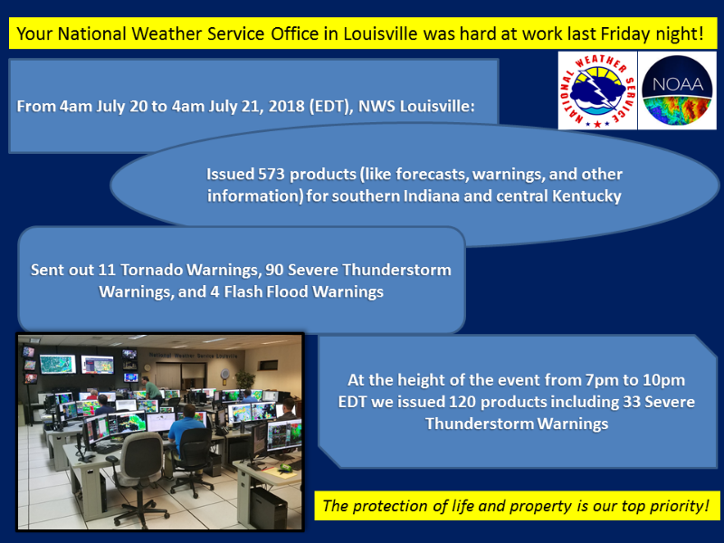
Overview
|
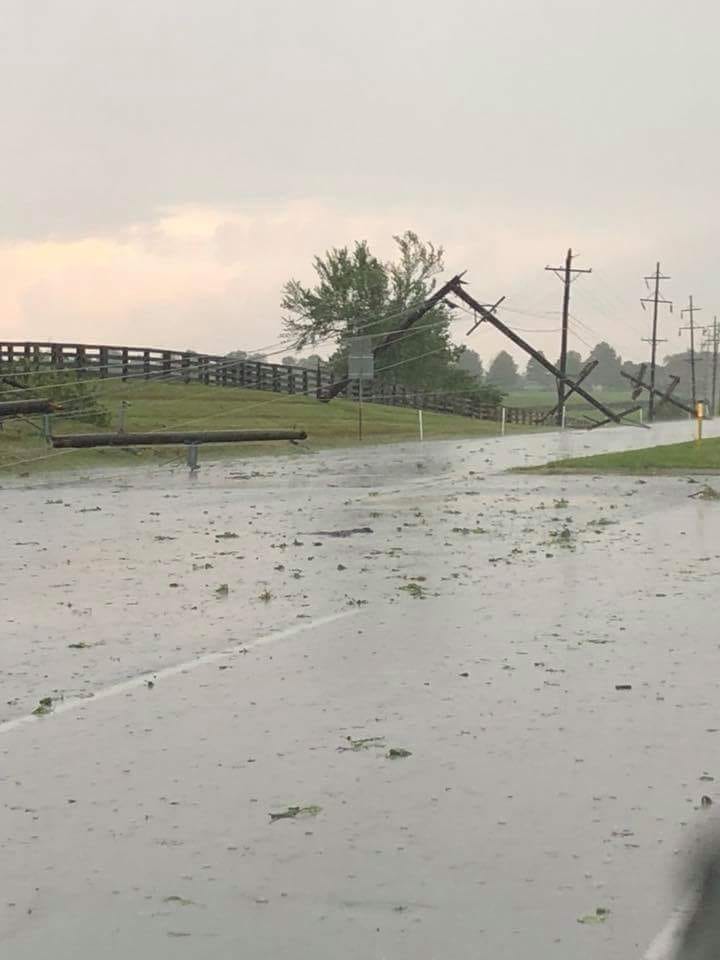
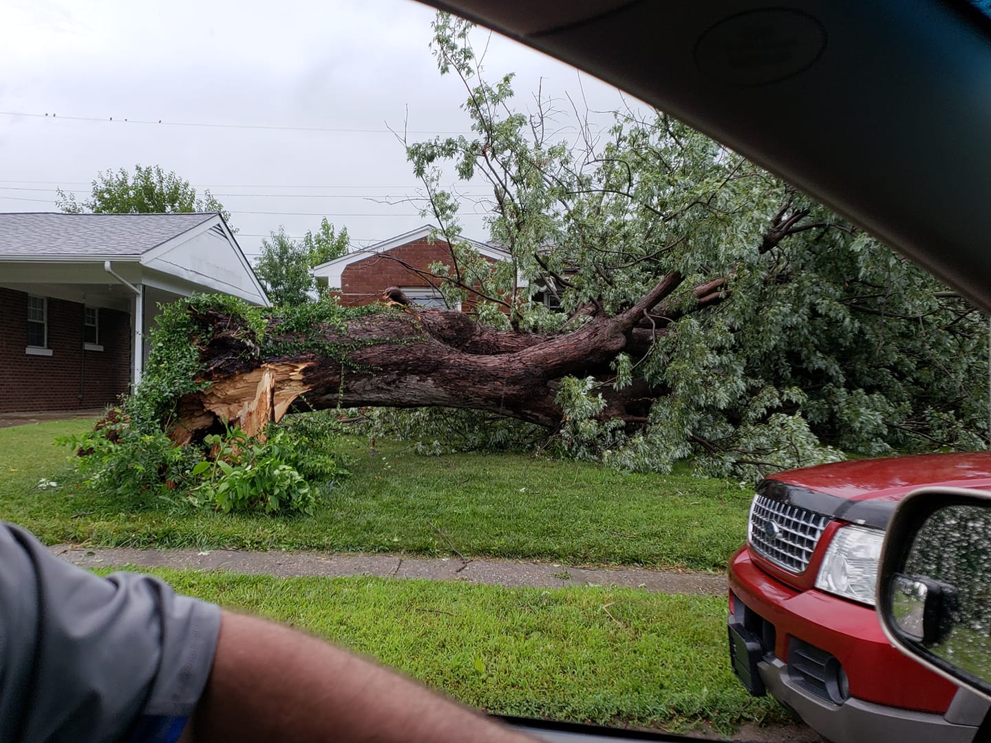
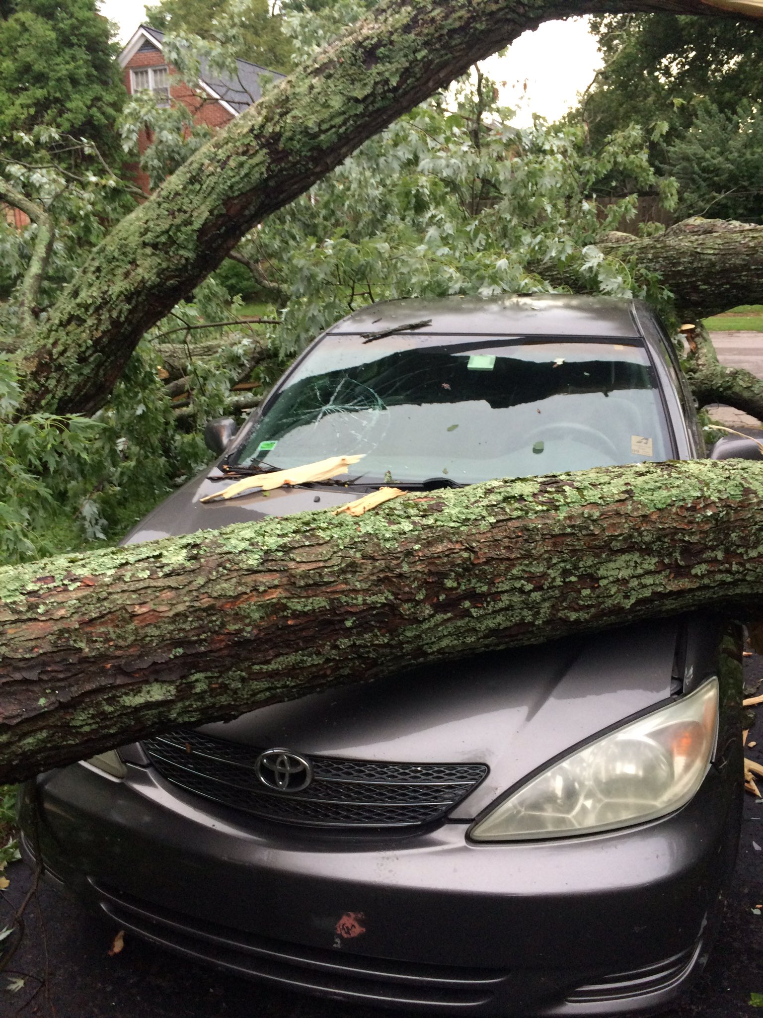
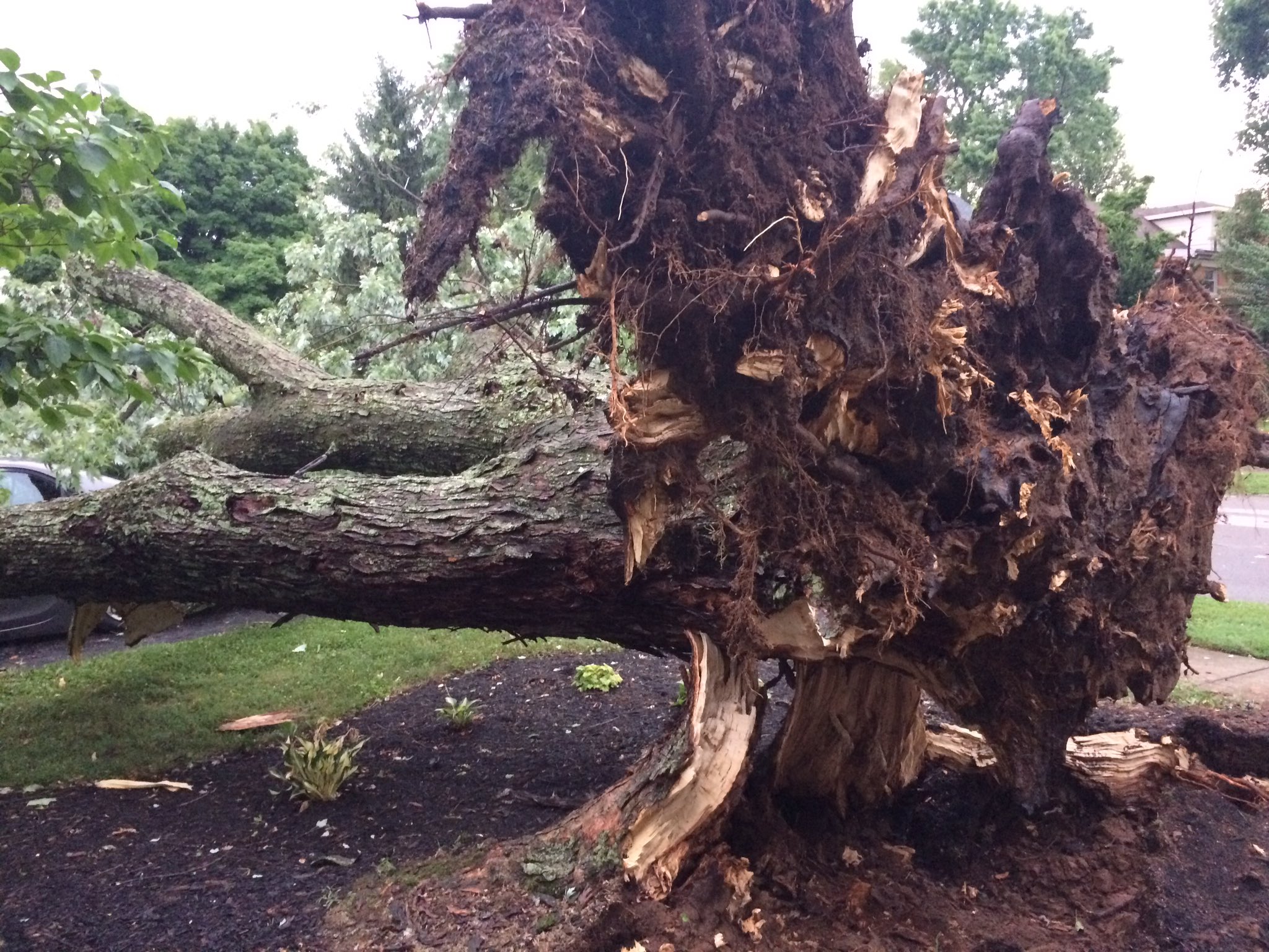
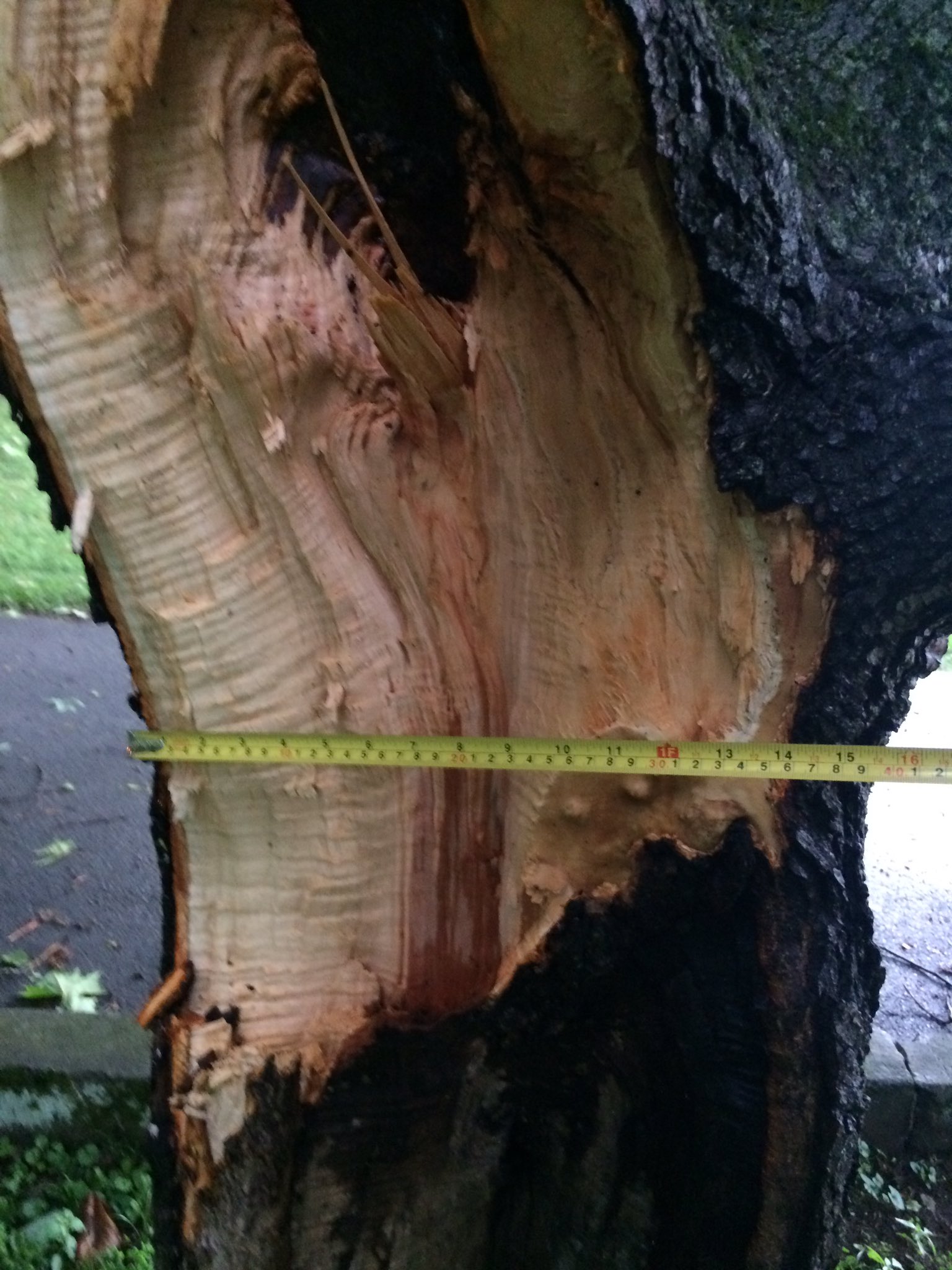
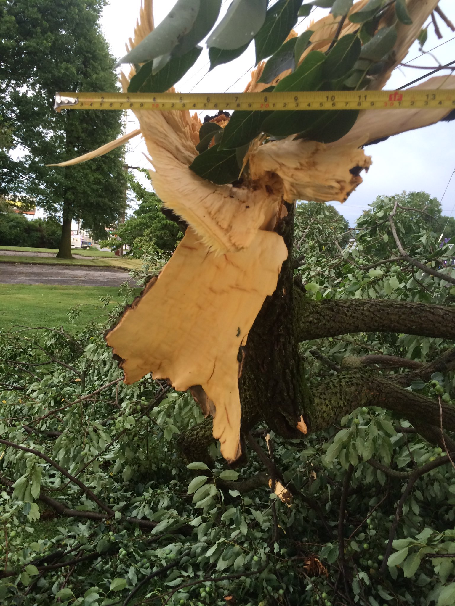
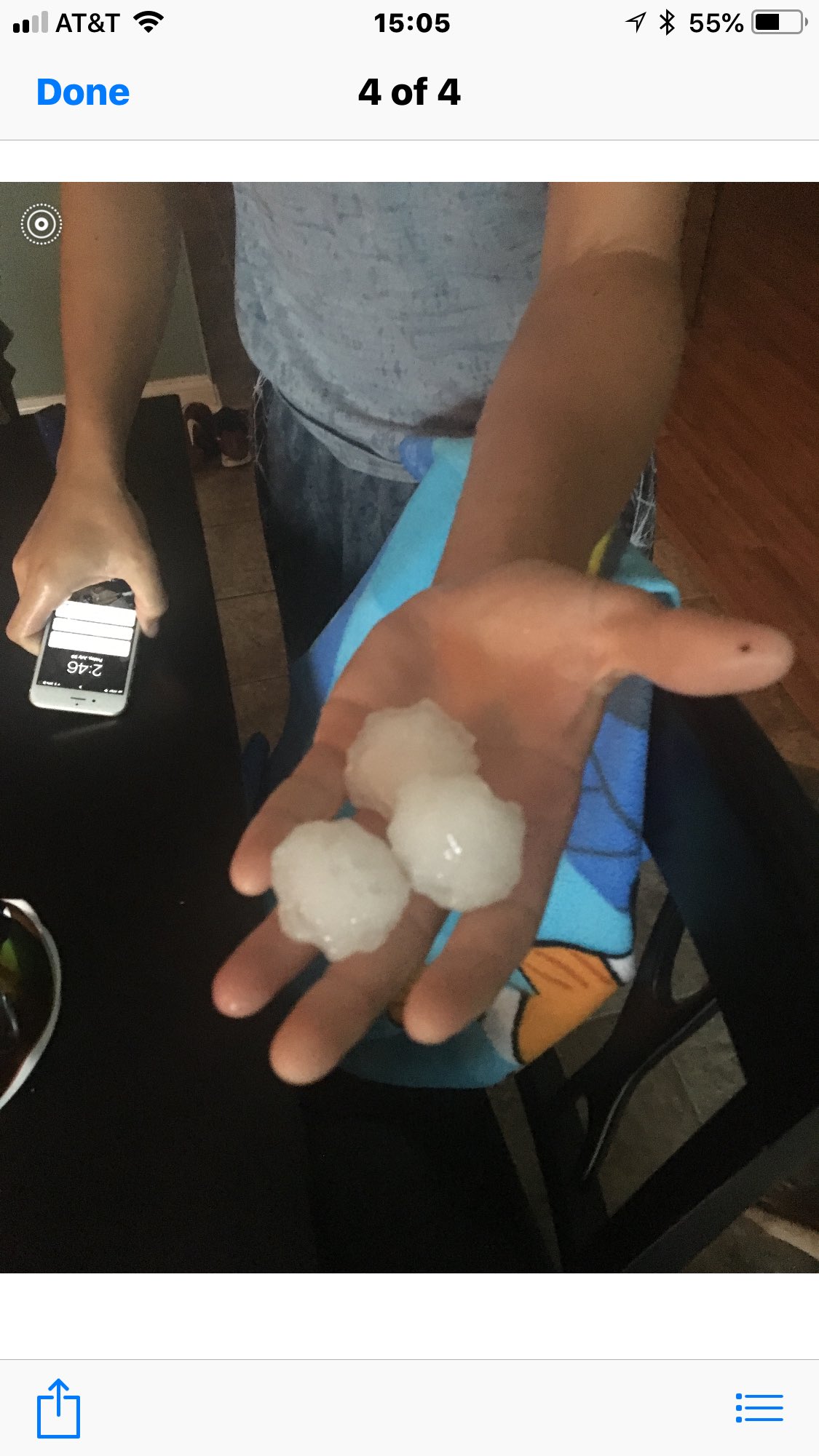
Rounds of severe storms hammered southern Indiana and central Kentucky on Friday, July 20, 2018 bringing very large hail, wind damage, heavy rain, and 4 confirmed tornadoes. The largest hail report we received was 4 inches in diameter (softball size) in Tompkinsville! The strongest measured wind gust was 70 mph at the Lexington Bluegrass Airport. NWS Damage Survey Teams confirmed four tornadoes: EF-1 Harrison County, IN EF-1 Hart County, KY EF-0 Metcalfe County, KY EF-0 Washington County, IN |
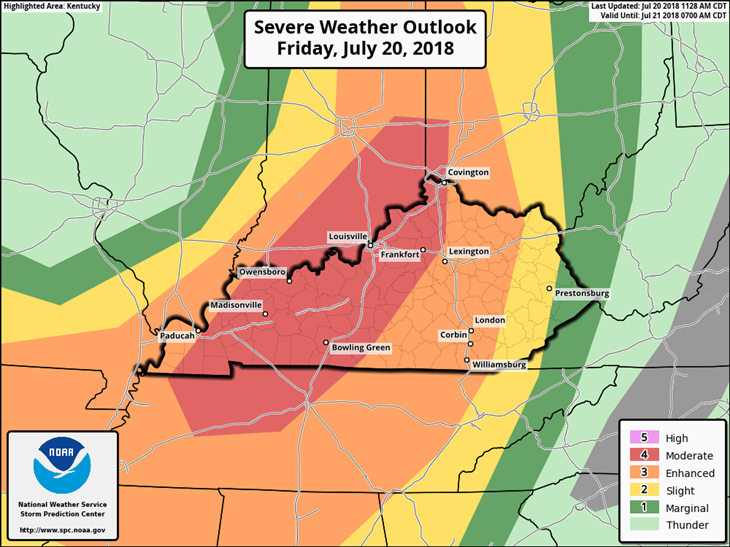 Storm Prediction Center graphic showing a Moderate Risk for Severe Weather |
Tornadoes:
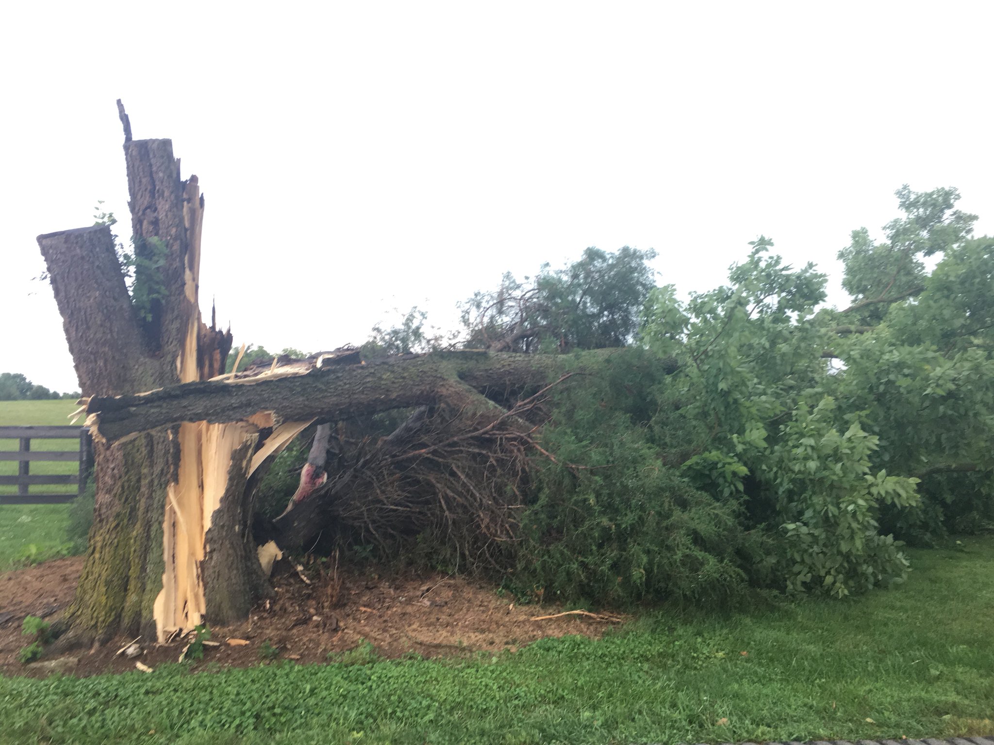
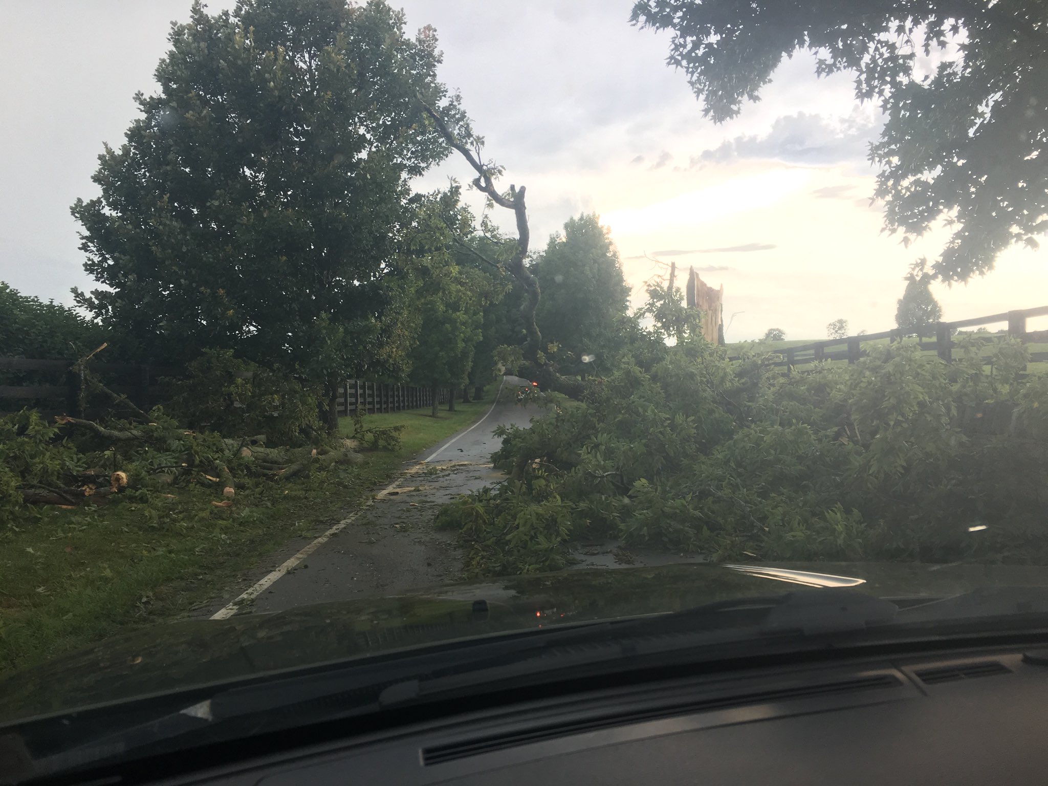
(Zoom in and click on the map icons below for damage survey info & photos)
|
|
||||||||||
|
||||||||||
|
Tornado - New Middletown
Track Map 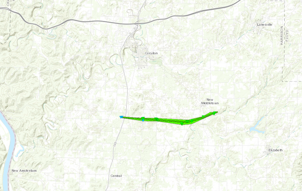 
|
||||||||||||||||
|
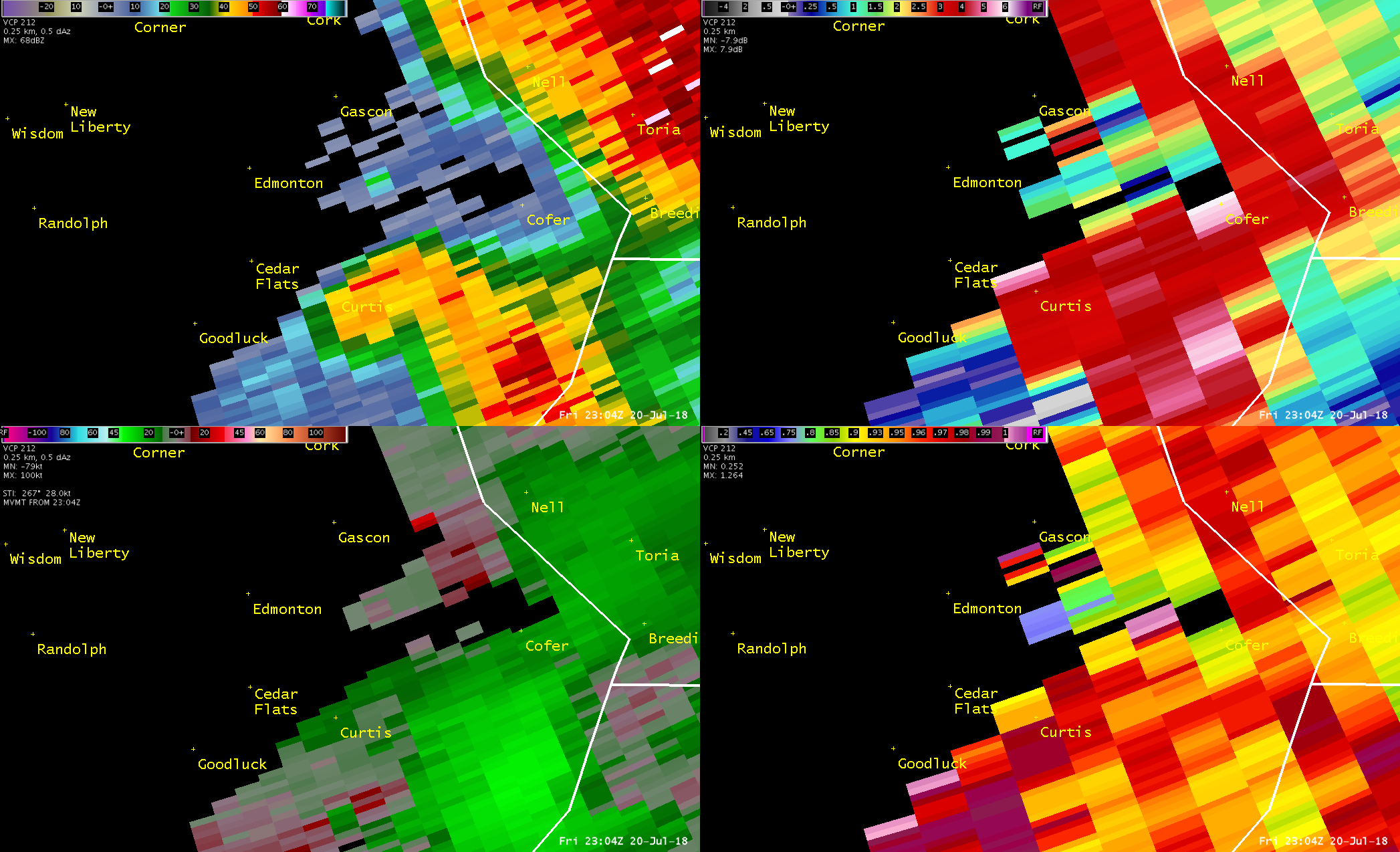
Tornado - Edmonton
Track Map 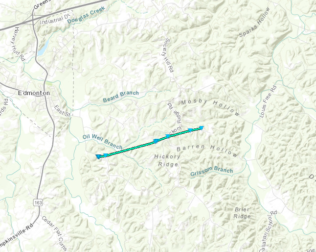
|
||||||||||||||||
|
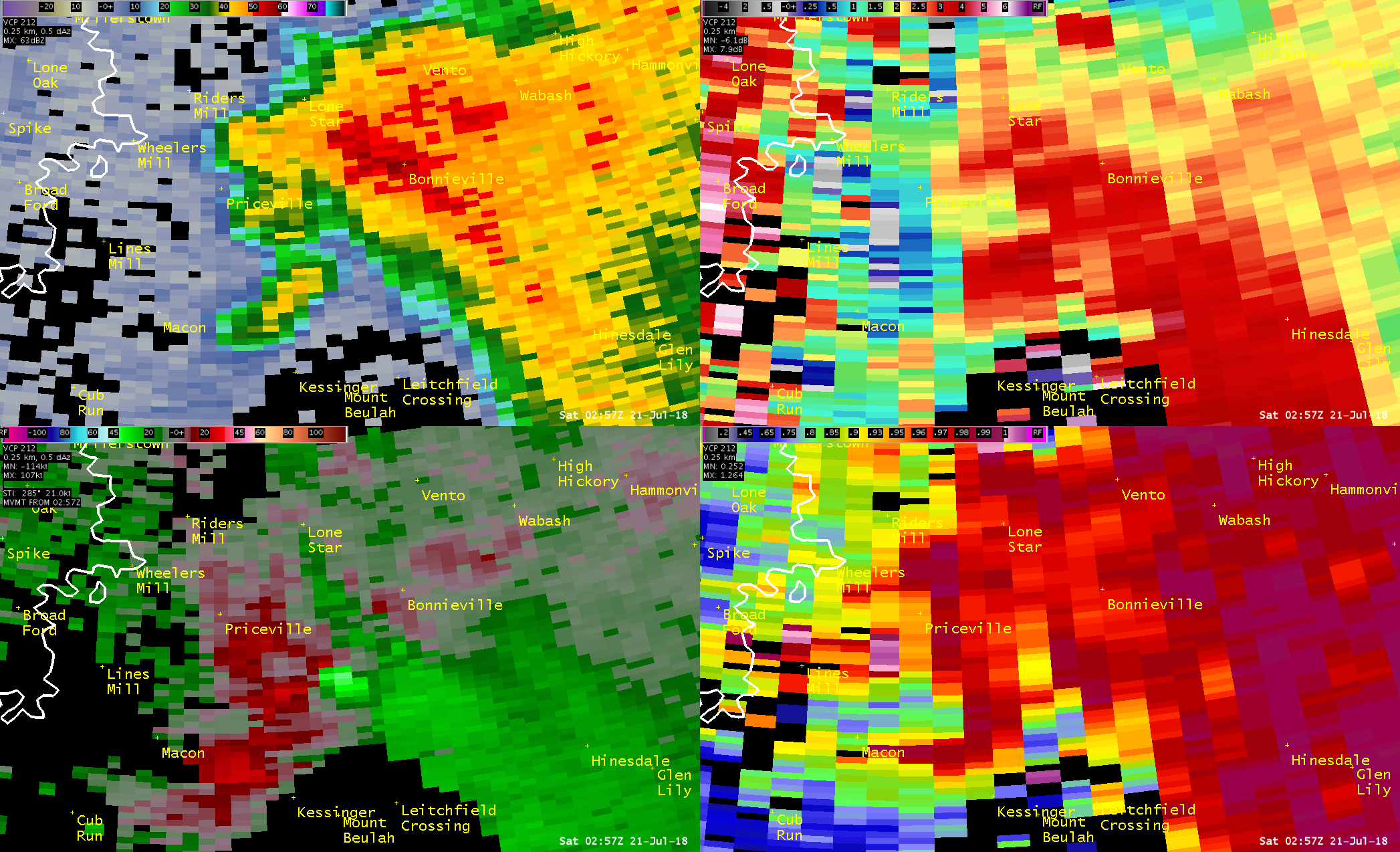
Tornado - Bonnieville
Track Map 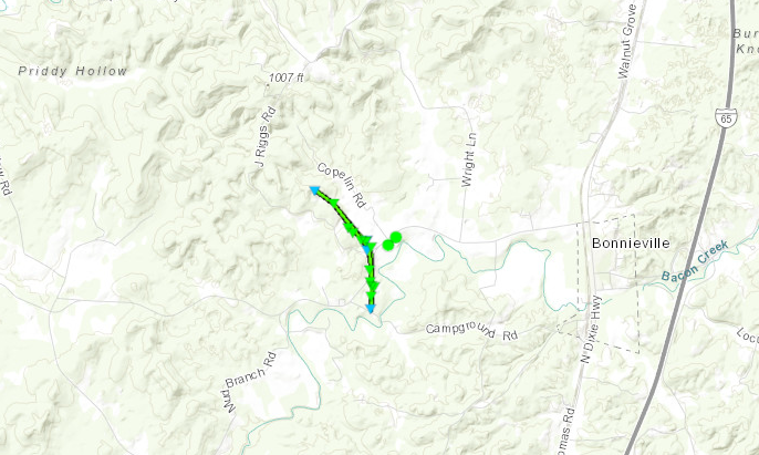
|
||||||||||||||||
|
Tornado - Salem, Indiana
Track Map 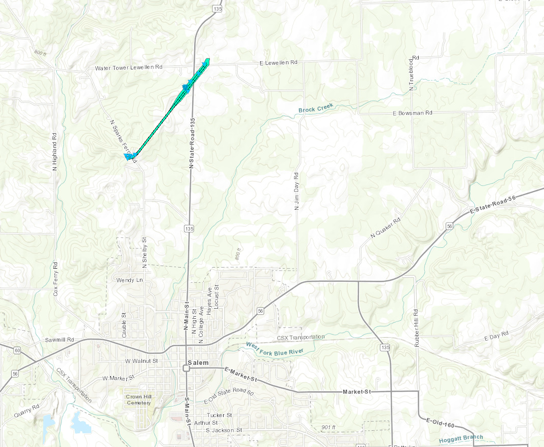
|
||||||||||||||||
The Enhanced Fujita (EF) Scale classifies tornadoes into the following categories:
| EF0 Weak 65-85 mph |
EF1 Moderate 86-110 mph |
EF2 Significant 111-135 mph |
EF3 Severe 136-165 mph |
EF4 Extreme 166-200 mph |
EF5 Catastrophic 200+ mph |
 |
|||||
Wind & Hail:
Wind
 |
 |
 |
 |
| Versailles, KY Courtesy of James Perkins | Versailles, KY Courtesy of James Perkins | Versailles, KY Courtesy of Judy Kincaid | Lexington, KY Courtesy of Krystal Porter |
 |
 |
 |
 |
| Lexington, KY Courtesy of W700 Weather Inc. | Lexington, KY Courtesy of W700 Weather Inc. | Lexington, KY Courtesy of W700 Weather Inc. | Lexington, KY Courtesy of W700 Weather Inc. |
Hail
 |
 |
 |
 |
| 4" Hail in Tompkinsville, KY Courtesy of Amy Arnett | Tompkinsville, KY Courtesy of Amy Arnett | Tompkinsville, KY Courtesy of Lisa Hutson (WHAS) | Coxs Creek, KY Courtesy of Brandi Stone |
 |
 |
 |
 |
| Louisville, KY - Shively Courtesy of Zach Meiman | Louisville, KY - PRP Courtesy of LeAnne Sergeant | Louisville, KY - Highview Courtesy of Bryce Jones | Casey County, KY Courtesy of Heather Luttrell |
Video:
Harrison County, IN EF-1 Tornado near Corydon, IN
Video Courtesy of Gregory Linker
Video courtesy of August Veron
Video courtesy of Patrick Koch
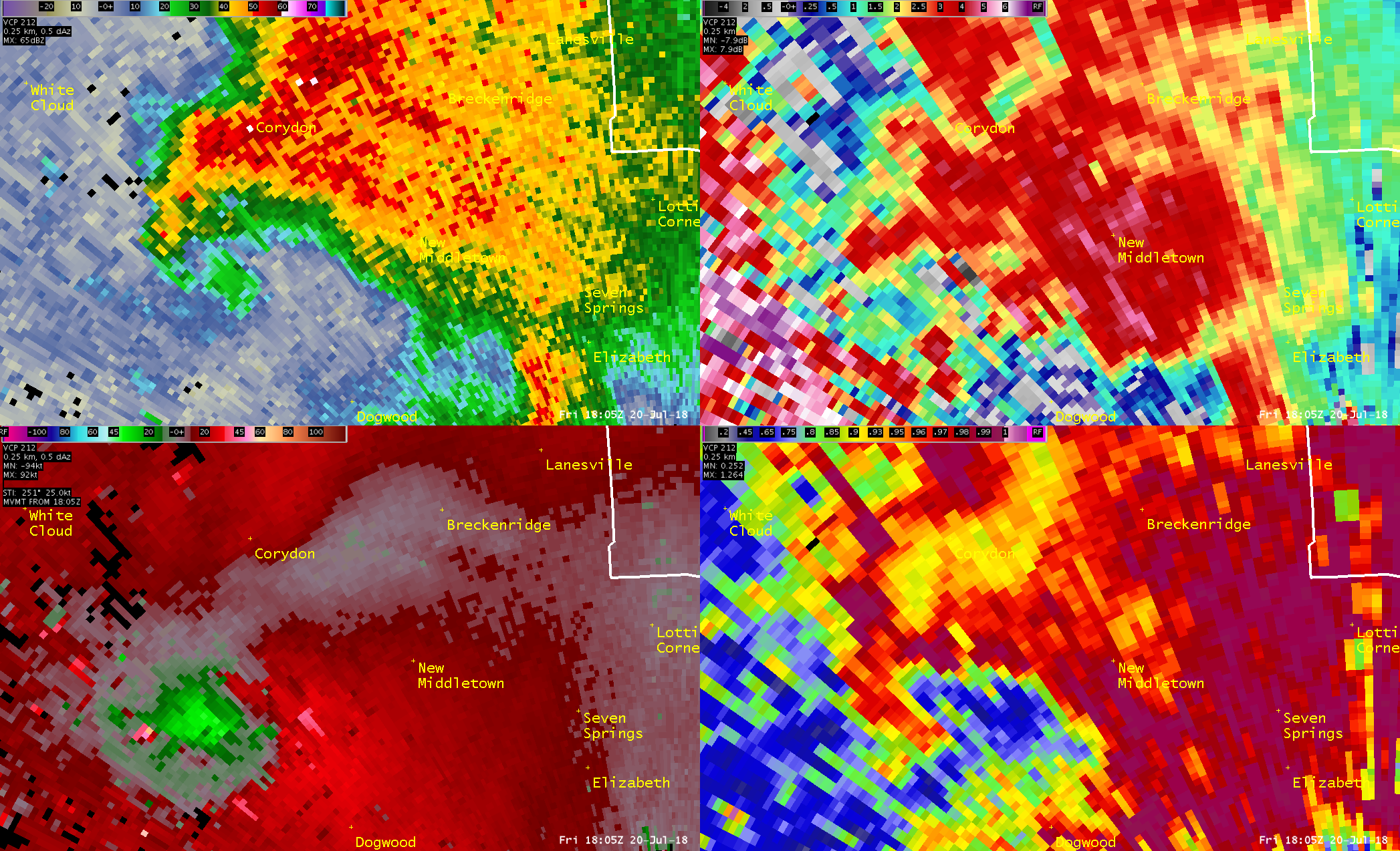
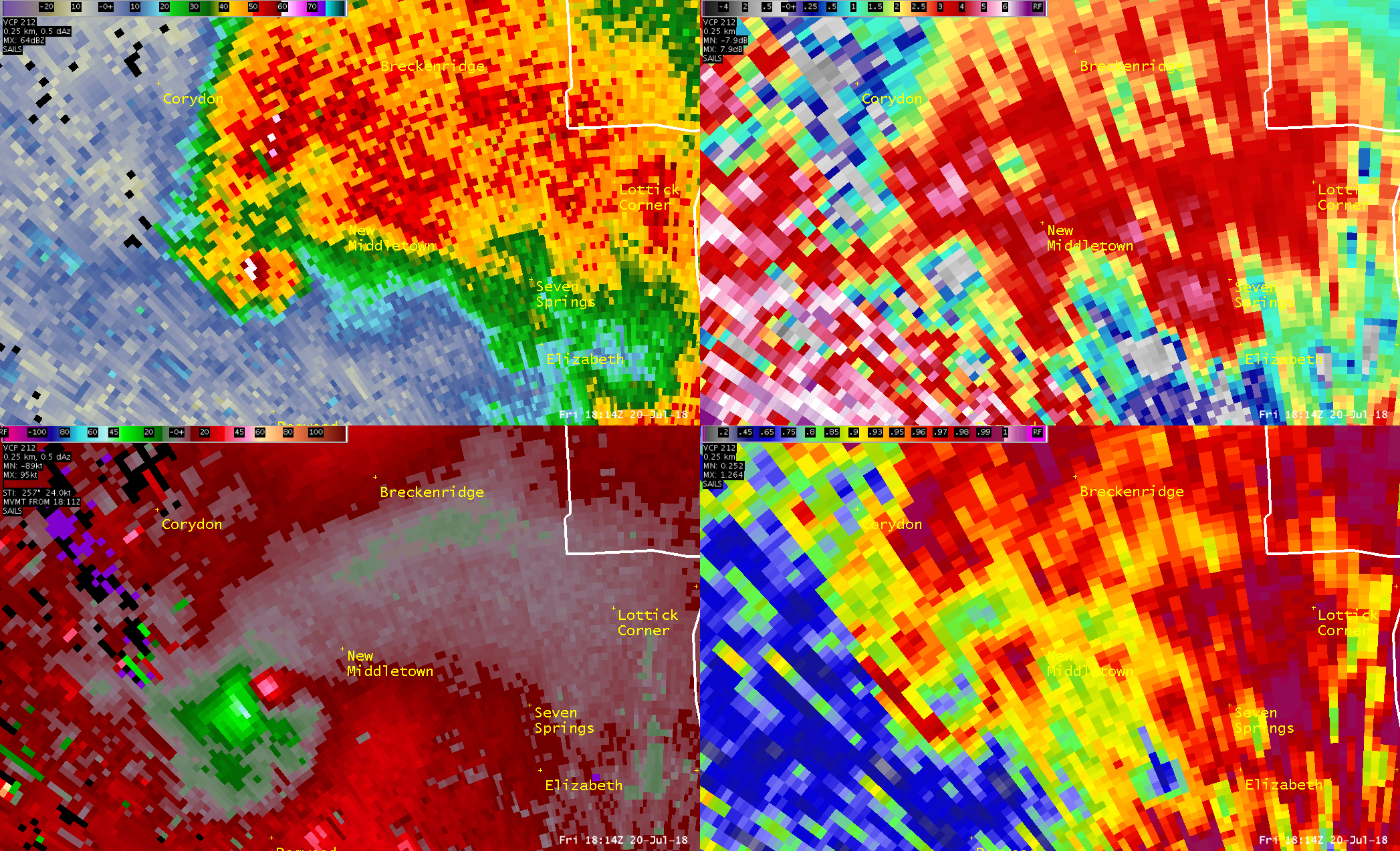
Radar:
Harrison County Tornado
 |
 |
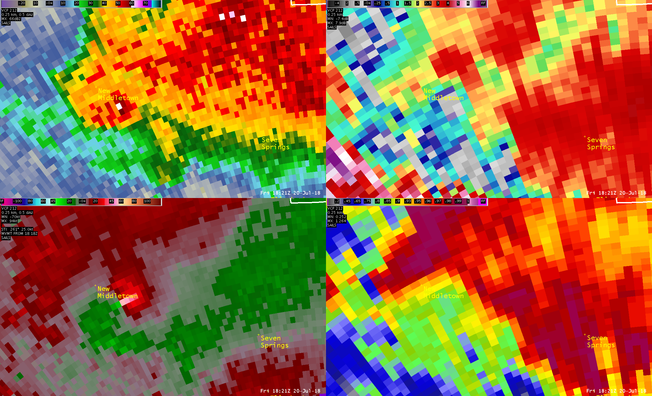 |
| 2:05PM EDT Z (Top left), ZDR (top right), SRM (bottom left), CC (bottom right) |
2:14PM EDT Z (Top left), ZDR (top right), SRM (bottom left), CC (bottom right) |
2:21PM EDT Z (Top left), ZDR (top right), SRM (bottom left), CC (bottom right) |
Metcalfe County Tornado
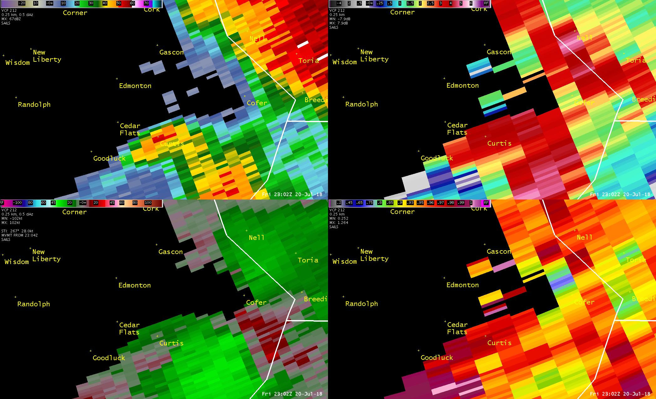 |
 |
| 6:02PM CDT Z (Top left), ZDR (top right), SRM (bottom left), CC (bottom right) |
6:04PM CDT Z (Top left), ZDR (top right), SRM (bottom left), CC (bottom right) |
Hart County Tornado
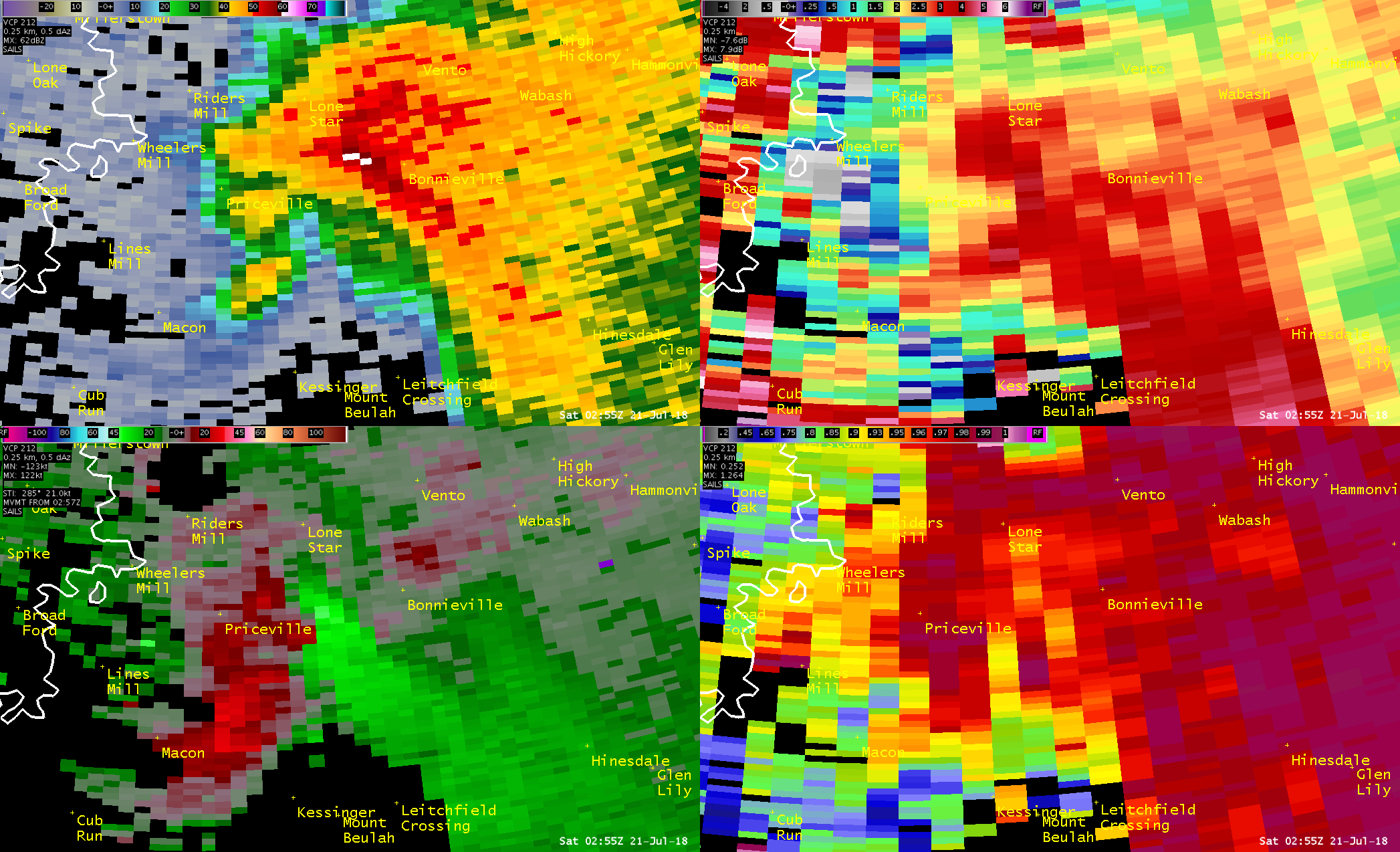 |
 |
| 9:55PM CDT Z (Top left), ZDR (top right), SRM (bottom left), CC (bottom right) |
9:57PM CDT Z (Top left), ZDR (top right), SRM (bottom left), CC (bottom right) |
Storm Reports
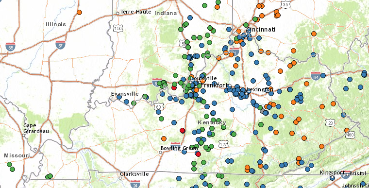 |
 |
Full List of Storm Reports for southern Indiana and central Kentucky:
..TIME... ...EVENT... ...CITY LOCATION... ...LAT.LON...
..DATE... ....MAG.... ..COUNTY LOCATION..ST.. ...SOURCE....
..REMARKS..
0810 AM TSTM WND DMG 6 W FORD 37.90N 84.35W
07/20/2018 FAYETTE KY BROADCAST MEDIA
TREES DOWN ON US 25 AND INTERSTATE 75 NEAR
MM 99.
0121 PM HAIL FREDONIA 38.18N 86.40W
07/20/2018 M2.00 INCH CRAWFORD IN TRAINED SPOTTER
0122 PM HAIL SULPHUR 38.23N 86.47W
07/20/2018 M1.75 INCH CRAWFORD IN PUBLIC
0128 PM HAIL LEAVENWORTH 38.20N 86.35W
07/20/2018 E1.25 INCH CRAWFORD IN EMERGENCY MNGR
0145 PM TSTM WND DMG 2 W ANDYVILLE 38.04N 86.41W
07/20/2018 MEADE KY 911 CALL CENTER
TREE DOWN ON STATE ROAD 144.
0201 PM HAIL CORYDON 38.21N 86.13W
07/20/2018 E1.75 INCH HARRISON IN EMERGENCY MNGR
HAIL FELL FOR 30 MIN IN DOWNTOWN CORYDON.
LARGEST WAS GOLFBALL SIZE.
0203 PM TSTM WND DMG 2 ESE BLOCHER 38.71N 85.61W
07/20/2018 JEFFERSON IN 911 CALL CENTER
A TREE BLEW DOWN ON STATE ROAD 56 EAST OF
STATE ROAD 3.
0204 PM TORNADO 4 N CENTRAL 38.15N 86.14W
07/20/2018 HARRISON IN NWS STORM SURVEY
ESTIMATED PEAK WIND 105 MPH; PATH LENGTH 6
MILES; PATH WIDTH 250 YARDS; TIME ON GROUND
16 MINUTES. DAMAGE INCLUDES SEVERAL BARNS
DESTROYED, SIGNIFICANT ROOF DAMAGE TO
SEVERAL HOMES, SIGNIFICANT TREE DAMAGE, POLE
BARN COMPLETELY DESTROYED, CYCLONIC CROP
DAMAGE, FLIPPED OVER SINGLE WIDE TRAILERS
AND A CAMPER.
0214 PM TSTM WND DMG 3 ESE SIROCCO 37.96N 86.23W
07/20/2018 MEADE KY 911 CALL CENTER
TREE DOWN ON HIGHWAY 79.
0215 PM HAIL HANOVER 38.72N 85.47W
07/20/2018 E0.75 INCH JEFFERSON IN TRAINED SPOTTER
STORM SPOTTER REPORTS 0.75 INCH HAIL IN
HANOVER, JEFFERSON COUNTY IN.
0225 PM TSTM WND DMG 3 S DOE VALLEY 37.95N 86.10W
07/20/2018 MEADE KY 911 CALL CENTER
POWER LINES AND TREE BLEW DOWN KNOCKING
POWER OUT TO SEVERAL IN THE AREA.
0227 PM HAIL MILTON 38.71N 85.37W
07/20/2018 E2.75 INCH TRIMBLE KY 911 CALL CENTER
0228 PM HAIL 1 S MADISON 38.74N 85.38W
07/20/2018 E1.75 INCH JEFFERSON IN 911 CALL CENTER
JEFFERSON COUNTY DISPATCH REPORTS GOLF BALL
SIZE HAIL AT THEIR LOCATION.
0228 PM HAIL PLEASURE RIDGE PAR 38.15N 85.85W
07/20/2018 E1.25 INCH JEFFERSON KY PUBLIC
0229 PM HAIL MADISON 38.76N 85.38W
07/20/2018 E1.50 INCH JEFFERSON IN EMERGENCY MNGR
0231 PM HAIL 1 W SCOTTSBURG 38.69N 85.80W
07/20/2018 E0.88 INCH SCOTT IN PUBLIC
0236 PM TSTM WND DMG 1 N SCOTTSBURG 38.70N 85.78W
07/20/2018 SCOTT IN 911 CALL CENTER
POWER LINES BLEW DOWN ON CEDAR STREET.
0236 PM TSTM WND DMG 1 N SCOTTSBURG 38.70N 85.78W
07/20/2018 SCOTT IN 911 CALL CENTER
POWER LINES BLEW DOWN ON GARDNER STREET.
0236 PM TSTM WND DMG 1 ESE SCOTTSBURG 38.68N 85.77W
07/20/2018 SCOTT IN 911 CALL CENTER
TREE BLEW DOWN ON MADISON STREET.
0236 PM TSTM WND DMG 1 W SCOTTSBURG 38.69N 85.81W
07/20/2018 SCOTT IN 911 CALL CENTER
POWER LINES BLEW DOWN ON WILLOW SHORE DRIVE.
0236 PM TSTM WND DMG 1 NNW SCOTTSBURG 38.70N 85.79W
07/20/2018 SCOTT IN 911 CALL CENTER
POWER LINES BLEW DOWN ON CARLA LANE.
0238 PM HAIL 1 NE BRIDGEPORT 38.18N 85.91W
07/20/2018 E1.50 INCH HARRISON IN PUBLIC
AT HORSESHOE SOUTHERN INDIANA CASINO.
0243 PM HAIL LITTLE YORK 38.70N 85.90W
07/20/2018 E1.00 INCH WASHINGTON IN NWS STORM SURVEY
SIGNIFICANT CROP DAMAGE CAUSED BY QUARTER
SIZED HAIL...REPORTED AT LITTLE YORK
WASHINGTON COUNTY IN.
0245 PM HAIL 3 SE SHIVELY 38.17N 85.78W
07/20/2018 E2.00 INCH JEFFERSON KY PUBLIC
0246 PM HAIL SHIVELY 38.20N 85.81W
07/20/2018 E1.75 INCH JEFFERSON KY LAW ENFORCEMENT
0248 PM HAIL 4 NW OKOLONA 38.19N 85.73W
07/20/2018 E1.00 INCH JEFFERSON KY ASOS
METAR KSDF GR 1.
0248 PM TSTM WND DMG DUPONT 38.90N 85.52W
07/20/2018 JEFFERSON IN EMERGENCY MNGR
POWER LINES DOWN.
0250 PM HAIL 3 SSE SHIVELY 38.16N 85.78W
07/20/2018 E1.75 INCH JEFFERSON KY AMATEUR RADIO
LARGE HAIL IN IROQUOIS PARK.
0250 PM HAIL 2 E SHIVELY 38.20N 85.77W
07/20/2018 E1.75 INCH JEFFERSON KY PUBLIC
GOLF BALL SIZE HAIL AT CHURCHILL DOWNS.
0253 PM HAIL 3 NNW OKOLONA 38.18N 85.72W
07/20/2018 E2.00 INCH JEFFERSON KY CO-OP OBSERVER
0257 PM HAIL 3 SE LOUISVILLE 38.22N 85.73W
07/20/2018 E1.00 INCH JEFFERSON KY PUBLIC
THURSTON AVENUE IN LOUISVILLE.
0257 PM TSTM WND DMG 2 S OKOLONA 38.12N 85.69W
07/20/2018 JEFFERSON KY TRAINED SPOTTER
REPORT OF LARGE MAPLE TREE DOWN NEAR SOUTH
PARK RD AND BLUE LICK RD.
0300 PM TSTM WND DMG 4 SSE LOUISVILLE 38.20N 85.73W
07/20/2018 JEFFERSON KY 911 CALL CENTER
LARGE TREE DOWN ON BUILDING.
0302 PM HAIL 4 NNW OKOLONA 38.20N 85.71W
07/20/2018 E1.00 INCH JEFFERSON KY TRAINED SPOTTER
4200 BLOCK OF POPLAR LEVEL ROAD.
0304 PM HAIL 1 SSE JEFFERSONTOWN 38.19N 85.57W
07/20/2018 E1.00 INCH JEFFERSON KY NWS EMPLOYEE
0310 PM TSTM WND DMG 6 NW LEXINGTON 38.10N 84.59W
07/20/2018 FAYETTE KY EMERGENCY MNGR
EIGHT STRUCTURES WITH TREES ON ROOFS. POWER
OUTAGES ALSO WIDESPREAD THROUGHOUT THE
COUNTY.
0318 PM TSTM WND DMG SHELBYVILLE 38.22N 85.23W
07/20/2018 SHELBY KY EMERGENCY MNGR
POWER LINES DOWN.
0329 PM HAIL 3 E SHEPHERDSVILLE 37.99N 85.66W
07/20/2018 E1.00 INCH BULLITT KY EMERGENCY MNGR
0340 PM TSTM WND GST 4 WSW MILLVILLE 38.12N 84.88W
07/20/2018 M51 MPH FRANKLIN KY MESONET
FRANKLIN COUNTY KY MESONET SITE.
0340 PM TSTM WND DMG FRANKFORT 38.17N 84.90W
07/20/2018 FRANKLIN KY COUNTY OFFICIAL
MULTIPLE TREES DOWN AROUND THE CITY, SOME ON
POWER LINES.
0342 PM TSTM WND DMG 1 NW ALTON 38.10N 84.95W
07/20/2018 ANDERSON KY EMERGENCY MNGR
TREE DOWN ON CAR WITH PEOPLE INSIDE OF IT.
MANY OTHER TREES DOWN IN THE AREA.
0345 PM TSTM WND GST 4 WSW MILLVILLE 38.12N 84.88W
07/20/2018 M61 MPH FRANKLIN KY MESONET
FRANKLIN COUNTY MESONET.
0352 PM HAIL 2 WNW COXS CREEK 37.92N 85.51W
07/20/2018 E2.50 INCH NELSON KY PUBLIC
0352 PM TSTM WND DMG 3 SSE MILLVILLE 38.10N 84.79W
07/20/2018 WOODFORD KY PUBLIC
TREES DOWN NEAR MCCRACKEN PIKE AND STEELE
ROAD.
0353 PM TSTM WND DMG 2 S VERSAILLES 38.03N 84.72W
07/20/2018 WOODFORD KY PUBLIC
0354 PM HAIL COXS CREEK 37.90N 85.47W
07/20/2018 E2.00 INCH NELSON KY PUBLIC
0359 PM TSTM WND DMG VERSAILLES 38.05N 84.73W
07/20/2018 WOODFORD KY EMERGENCY MNGR
LARGE TREES DOWN.
0401 PM TSTM WND DMG 3 SSW MIDWAY 38.11N 84.70W
07/20/2018 WOODFORD KY PUBLIC
LARGE TREES DOWN ALONG MIDWAY ROAD.
0402 PM TSTM WND DMG 2 SSW LEXINGTON 38.02N 84.52W
07/20/2018 FAYETTE KY BROADCAST MEDIA
TREE ON A HOME IN VENICE PARK.
0403 PM TSTM WND DMG 2 NW MIDWAY 38.17N 84.71W
07/20/2018 WOODFORD KY PUBLIC
CORRECTED LSR FOR TIME BASED ON RADAR.
0405 PM TSTM WND DMG 1 SSE LEXINGTON 38.04N 84.50W
07/20/2018 FAYETTE KY NEWSPAPER
TREE ON A HOUSE, ROSE AND MAXWELL.
0405 PM TSTM WND DMG 3 SSW LEXINGTON 38.00N 84.52W
07/20/2018 FAYETTE KY PUBLIC
TREE DOWN ACROSS MALIBU DRIVE.
0406 PM TSTM WND GST 6 W LEXINGTON 38.04N 84.60W
07/20/2018 M70 MPH FAYETTE KY OFFICIAL NWS OBS
MEASURED AT BLUE GRASS AIRPORT.
0407 PM TSTM WND DMG 4 NE LEXINGTON 38.09N 84.45W
07/20/2018 FAYETTE KY PUBLIC
TREE DOWNED ON LESLIE DRIVE.
0410 PM TSTM WND DMG 6 NW LEXINGTON 38.11N 84.58W
07/20/2018 FAYETTE KY EMERGENCY MNGR
CORRECTED LSR FOR TIME BASED ON RADAR. EIGHT
STRUCTURES WITH TREES ON ROOF. POWER OUTAGES
ALSO WIDESPREAD THROUGH COUNTY.
0415 PM TSTM WND DMG 1 SSW CHAPLIN 37.88N 85.23W
07/20/2018 NELSON KY LAW ENFORCEMENT
TREES DOWN NEAR OLD TUNNEL MILL ROAD.
0417 PM TSTM WND DMG 4 NNE CENTERVILLE 38.27N 84.35W
07/20/2018 BOURBON KY BROADCAST MEDIA
ROOF TORN OFF A BARN AND MULTIPLE TREES DOWN
ON BRENTSVILLE ROAD.
0424 PM TSTM WND DMG 5 SW LEXINGTON 38.01N 84.57W
07/20/2018 FAYETTE KY PUBLIC
TREE BRANCHES SHEARED 6 FT ABOVE GROUND.
0430 PM TSTM WND DMG 3 N KEENE 37.98N 84.62W
07/20/2018 JESSAMINE KY 911 CALL CENTER
MULTIPLE TREES DOWN FROM STRONG WINDS.
0435 PM TSTM WND DMG 4 NNW CARLISLE 38.37N 84.07W
07/20/2018 NICHOLAS KY 911 CALL CENTER
TREES DOWN ON CALCUTTA RD.
0438 PM TSTM WND DMG 4 WSW MOOREFIELD 38.23N 84.00W
07/20/2018 NICHOLAS KY 911 CALL CENTER
TREES REPORTED DOWN AT SOMERSET RD NICHOLAS
COUNTY KY.
0443 PM TSTM WND DMG 1 ENE CARLISLE 38.32N 84.02W
07/20/2018 NICHOLAS KY 911 CALL CENTER
TREES DOWN ON YOUNG ST.
0507 PM TSTM WND DMG 1 ESE HARRODSBURG 37.76N 84.82W
07/20/2018 MERCER KY 911 CALL CENTER
WIDESPREAD TREE DAMAGE ALONG BURGIN ROAD.
0513 PM TSTM WND DMG REDHOUSE 37.83N 84.27W
07/20/2018 MADISON KY COUNTY OFFICIAL
TREES DOWN.
0518 PM TSTM WND DMG 4 WNW REDHOUSE 37.86N 84.33W
07/20/2018 MADISON KY EMERGENCY MNGR
TREES DOWN.
0527 PM HAIL 4 ESE REDHOUSE 37.80N 84.20W
07/20/2018 E0.75 INCH MADISON KY TRAINED SPOTTER
0531 PM TSTM WND DMG 2 NW MIDWAY 38.16N 84.71W
07/20/2018 WOODFORD KY PUBLIC
0611 PM HAIL LORETTO 37.64N 85.40W
07/20/2018 E0.75 INCH MARION KY TRAINED SPOTTER
0615 PM HAIL LORETTO 37.64N 85.40W
07/20/2018 E1.25 INCH MARION KY TRAINED SPOTTER
0622 PM HAIL JACKTOWN 37.45N 85.02W
07/20/2018 E1.00 INCH CASEY KY PUBLIC
0624 PM HAIL 3 W KNOB LICK 37.08N 85.74W
07/20/2018 E1.00 INCH METCALFE KY FIRE DEPT/RESCUE
0629 PM HAIL 1 W SULPHUR WELL 37.10N 85.64W
07/20/2018 E1.75 INCH METCALFE KY BROADCAST MEDIA
VIEWER REPORTS GOLF BALL SIZE HAIL NEAR
SULPHUR WELL.
0630 PM HAIL 1 SW SAINT CATHERINE 37.69N 85.26W
07/20/2018 E1.75 INCH WASHINGTON KY 911 CALL CENTER
GOLF BALL SIZE HAIL ALONG HIGHWAY 152.
0633 PM TSTM WND DMG SAINT CATHERINE 37.70N 85.25W
07/20/2018 WASHINGTON KY 911 CALL CENTER
TREES DOWN AT BARDSTOWN ROAD AND HIGHWAY
152.
0639 PM TSTM WND DMG 1 SE EDMONTON 36.98N 85.61W
07/20/2018 METCALFE KY EMERGENCY MNGR
FIRE CHIEF REPORTS TREES, POWER LINES DOWN
AND SHOP DESTROYED NEAR EDMONTON ALONG
HIGHWAY 496. HIGHWAY 496 CLOSED DUE TO
DEBRIS.
0643 PM HAIL 5 W SALOMA 37.41N 85.50W
07/20/2018 E1.50 INCH TAYLOR KY LAW ENFORCEMENT
IN THE MAC COMMUNITY.
0646 PM HAIL LEBANON 37.57N 85.25W
07/20/2018 E1.00 INCH MARION KY 911 CALL CENTER
REPORTED AT BEDROCK LANE LEBANON MARION
COUNTY KY.
0647 PM HAIL 1 ENE ELK HORN 37.32N 85.27W
07/20/2018 E1.00 INCH TAYLOR KY TRAINED SPOTTER
0649 PM TSTM WND DMG 1 SSW MIDDLEBURG 37.34N 84.82W
07/20/2018 CASEY KY 911 CALL CENTER
TREES BLOCKING THE ROAD ON N KY 501.
0649 PM TSTM WND GST CAMPBELLSVILLE 37.34N 85.34W
07/20/2018 M60 MPH TAYLOR KY LAW ENFORCEMENT
0654 PM HAIL 2 SE MIDDLEBURG 37.32N 84.79W
07/20/2018 E2.50 INCH CASEY KY PUBLIC
0657 PM HAIL 4 NNE BRADFORDSVILLE 37.56N 85.13W
07/20/2018 E1.00 INCH MARION KY 911 CALL CENTER
NEAR BRADFORDSVILLE.
0659 PM HAIL 1 WNW ROCKBRIDGE 36.79N 85.69W
07/20/2018 E1.00 INCH MONROE KY TRAINED SPOTTER
0700 PM HAIL 5 E HOBSON 37.42N 85.28W
07/20/2018 E1.75 INCH TAYLOR KY PUBLIC
0701 PM HAIL GRADYVILLE 37.08N 85.42W
07/20/2018 E1.50 INCH ADAIR KY TRAINED SPOTTER
0703 PM TORNADO 2 SE EDMONTON 36.96N 85.59W
07/20/2018 METCALFE KY NWS STORM SURVEY
ESTIMATED PEAK WIND 80-85 MPH; PATH LENGTH
2.1 MILES; PATH WIDTH 60 YARDS; ON THE
GROUND FOR 2 MINUTES. DAMAGE INCLUDES
CARPORT OVERTURNED, METAL ROOF TORN OFF OF
METAL OUTBUILDING, NUMEROUS TREES SNAPPED,
PUSHED MOBILE HOME OFF BLOCKS AND BREAKING
WINDOWS AND ROOF SHINGLES RIPPED OFF.
0718 PM HAIL 1 NNW MEMPHIS 38.49N 85.77W
07/20/2018 E0.88 INCH CLARK IN PUBLIC
0719 PM HAIL 4 SE GRADYVILLE 37.05N 85.37W
07/20/2018 E1.75 INCH ADAIR KY BROADCAST MEDIA
VIEWER REPORT OF HAIL A LITTLE LARGER THAN
GOLF BALL SIZE NEAR COLUMBIA.
0719 PM HAIL 3 S CAMPBELLSVILLE 37.31N 85.34W
07/20/2018 E1.00 INCH TAYLOR KY PUBLIC
0726 PM TSTM WND DMG 1 SSW BLOCHER 38.71N 85.66W
07/20/2018 SCOTT IN 911 CALL CENTER
A LARGE TREE WAS REPORTED DOWN ON STATE ROAD
56 NEAR BLOCHER.
0726 PM TSTM WND DMG 2 N HENRYVILLE 38.56N 85.76W
07/20/2018 CLARK IN BROADCAST MEDIA
LISTENER REPORTS TREES DOWN AT US 31 AND
BROWNSTOWN ROAD NORTH OF HENRYVILLE.
0730 PM HAIL 2 ESE MARROWBONE 36.81N 85.47W
07/20/2018 E1.75 INCH CUMBERLAND KY PUBLIC
0742 PM HAIL 2 W BUCKNER 38.38N 85.47W
07/20/2018 E1.00 INCH OLDHAM KY PUBLIC
0745 PM TSTM WND DMG BROWNSBORO 38.36N 85.50W
07/20/2018 OLDHAM KY PUBLIC
REPORTED AT 7511 HWY 329 CRESTWOOD TREES AND
POWERLINES DOWN.
0754 PM HAIL TOMPKINSVILLE 36.70N 85.69W
07/20/2018 M4.00 INCH MONROE KY BROADCAST MEDIA
VERIFIED PHOTO ON TWITTER. TIME ESTIMATED
FROM RADAR.
0800 PM HAIL TOMPKINSVILLE 36.70N 85.69W
07/20/2018 E1.00 INCH MONROE KY PUBLIC
REPORTED AT TOMPKINSVILLE.
0810 PM FLASH FLOOD 1 W SAINT MATTHEWS 38.25N 85.66W
07/20/2018 JEFFERSON KY EMERGENCY MNGR
WATER RESCUE--CAR DROVE INTO HIGH WATER ON
LEXINGTON ROAD AT OXFORD PLACE.
0810 PM TSTM WND DMG 1 SSW SAINT MATTHEWS 38.24N 85.64W
07/20/2018 JEFFERSON KY EMERGENCY MNGR
TREE ON A HOUSE AT ALTON RD AND SHERRIN AVE
IN ST. MATTHEWS.
0810 PM HAIL LEAVENWORTH 38.20N 86.35W
07/20/2018 E0.75 INCH CRAWFORD IN PUBLIC
0810 PM HAIL 1 ENE COLUMBIA 37.10N 85.29W
07/20/2018 E1.00 INCH ADAIR KY PUBLIC
0810 PM HAIL CURBY 38.24N 86.38W
07/20/2018 E1.00 INCH CRAWFORD IN PUBLIC
0810 PM HAIL 1 NNE CURBY 38.25N 86.38W
07/20/2018 E1.00 INCH CRAWFORD IN NWS EMPLOYEE
0810 PM HAIL CAREFREE 38.24N 86.36W
07/20/2018 E1.00 INCH CRAWFORD IN PUBLIC
0815 PM TSTM WND DMG 2 SW PEWEE VALLEY 38.30N 85.51W
07/20/2018 JEFFERSON KY PUBLIC
TREE DAMAGE ALONG OLD LAGRANGE ROAD NEAR
WESTPORT ROAD.
0820 PM LIGHTNING 1 ENE WACO 37.74N 84.14W
07/20/2018 MADISON KY FIRE DEPT/RESCUE
STRUCTURE FIRE DUE TO LIGHTNING STRIKE ON
WACO LOOP.
0822 PM HAIL 4 NW TELL CITY 38.00N 86.80W
07/20/2018 E0.75 INCH PERRY IN AMATEUR RADIO
PENNY SIZE HAIL NEAR TROY.
0828 PM HAIL CLARKSVILLE 38.32N 85.77W
07/20/2018 E1.00 INCH CLARK IN TRAINED SPOTTER
0846 PM     TSTM WND DMG     2 WSW VERSAILLES        38.04N 84.76W
07/20/2018                   WOODFORD           KY   EMERGENCY MNGR

            DELAYED REPORT...A COUPLE OF REPORTS PHONED
            INTO DISPATCH THAT LIKELY WERE ASSOCIATED
            WITH THE EVENING WARNING AND NOT THE
            AFTERNOON. PART OF THE ROOF AT LEDVANCE WAS
            LOST, WITH WATER COMING INTO A COMPUTER
            ROOM. ALSO NEARBY AT EMERSON DR AND TYRONE
            PIKE A TREE WAS DOWN BLOCKING THE ROAD. TIME
            ESTIMATED BASED ON RADAR.
0855 PM     HAIL             1 N VALLEY STATION      38.12N 85.85W
07/20/2018  M1.00 INCH       JEFFERSON          KY   PUBLIC

            HAIL WAS MEASURED AT STONESTREET ROAD. TIME
            FROM RADAR.

0901 PM     HAIL             1 SW VALLEY STATION     38.09N 85.88W
07/20/2018  E1.00 INCH       JEFFERSON          KY   PUBLIC


0910 PM     FLASH FLOOD      1 W SAINT MATTHEWS      38.25N 85.66W
07/20/2018                   JEFFERSON          KY   EMERGENCY MNGR

            CORRECTED LSR FOR TIME BASED ON RADAR. WATER
            RESCUE -- CAR DROVE INTO HIGH WATER ON
            LEXINGTON ROAD AT OXFORD PLACE.

0913 PM     HAIL             LANESVILLE              38.24N 85.99W
07/20/2018  E0.50 INCH       HARRISON           IN   PUBLIC


0914 PM     TSTM WND DMG     5 ENE WEST POINT        38.01N 85.86W
07/20/2018                   BULLITT            KY   911 CALL CENTER

            A LARGE TREE WAS REPORTED DOWN ON MERKER
            LANE. TIME BASED ON RADAR.

0919 PM     TSTM WND DMG     5 ENE WEST POINT        38.01N 85.87W
07/20/2018                   BULLITT            KY   911 CALL CENTER

            A TREE FELL AND KNOCKED DOWN POWER LINES AT
            HIGHWAY 44 AND KNOB CREEK. TIME BASED ON
            RADAR.

0919 PM     HAIL             1 W CENTRAL BARREN      38.37N 86.11W
07/20/2018  E1.75 INCH       HARRISON           IN   EMERGENCY MNGR

            GOLF BALL SIZE HAIL ALONG HANCOCK CHAPEL
            ROAD.

0922 PM     TSTM WND DMG     4 NW SHEPHERDSVILLE     38.02N 85.77W
07/20/2018                   BULLITT            KY   911 CALL CENTER

            THERE WAS A TREE DOWN ON MOUNT ELMIRA ROAD.
            TIME BASED ON RADAR.

0924 PM     TSTM WND DMG     2 E GEORGETOWN          38.30N 85.93W
07/20/2018                   FLOYD              IN   PUBLIC

            DELAYED REPORT...FACEBOOK POST ABOUT DAMAGE
            ON EDWARDSVILLE-GALENA ROAD. SAID STORM TOOK
            OUT TREES AND ELECTRICAL POSTS AND WIRES.
            TIME ESTIMATED BASED ON RADAR.

0925 PM     TSTM WND DMG     5 NE MOUNT WASHINGTON   38.09N 85.48W
07/20/2018                   BULLITT            KY   911 CALL CENTER

            THERE WAS A TREE REPORTED DOWN ON KINGSWOOD
            AVENUE AT KINGS CHURCH ROAD. TIME FROM
            RADAR.

0925 PM     TSTM WND DMG     3 NW SHEPHERDSVILLE     38.01N 85.75W
07/20/2018                   BULLITT            KY   911 CALL CENTER

            THERE WAS A TREE REPORTED DOWN ON THE 1500
            BLOCK OF RAYMOND ROAD. TIME BASED ON RADAR.

0925 PM     TSTM WND DMG     3 NW SHEPHERDSVILLE     38.02N 85.75W
07/20/2018                   BULLITT            KY   911 CALL CENTER

            TWO TREES AND POWER LINES WERE REPORTED DOWN
            ON THE 800 BLOCK OF WALLS HOLLOW ROAD NORTH.

0927 PM     TSTM WND DMG     4 SSE HILLVIEW          38.02N 85.65W
07/20/2018                   BULLITT            KY   911 CALL CENTER

            A POWER LINE WAS REPORTED DOWN ON SANDY
            DRIVE. TIME BASED ON RADAR.

0933 PM     TSTM WND DMG     3 NNW DEATSVILLE        37.94N 85.59W
07/20/2018                   BULLITT            KY   911 CALL CENTER

            THERE WAS A TREE DOWN ON LOTUS DRIVE NEAR
            DEATSVILLE ROAD. TIME BASED ON RADAR.

0934 PM     TSTM WND DMG     JEFFERSONVILLE          38.28N 85.72W
07/20/2018                   CLARK              IN   TRAINED SPOTTER

            LARGE TREE, MULTIPLE LIMBS, AND POWER LINES
            DOWNED JUST NE OF DOWNTOWN JEFFERSONVILLE.

0940 PM     TSTM WND GST     2 SW SAINT MATTHEWS     38.23N 85.66W
07/20/2018  M60 MPH          JEFFERSON          KY   ASOS


0941 PM     TSTM WND DMG     3 N DEATSVILLE          37.95N 85.56W
07/20/2018                   BULLITT            KY   911 CALL CENTER

            A TREE WAS REPORTED DOWN ON WOODSDALE ROAD.
            TIME BASED ON RADAR.

0941 PM     HAIL             2 NNE HILLVIEW          38.10N 85.67W
07/20/2018  E1.00 INCH       JEFFERSON          KY   PUBLIC


0941 PM     FLOOD            2 SSW HIGHVIEW          38.11N 85.64W
07/20/2018                   JEFFERSON          KY   AMATEUR RADIO

            6-8 INCHES OF WATER REPORTED ON STREET OF
            CUL-DE-SAC.

0945 PM     HAIL             MCDANIELS               37.60N 86.43W
07/20/2018  E1.00 INCH       BRECKINRIDGE       KY   CO-OP OBSERVER


0945 PM     FLASH FLOOD      3 E ANCHORAGE           38.27N 85.49W
07/20/2018                   JEFFERSON          KY   NWS EMPLOYEE

            OLD HENRY ROAD FLOODED TO FACTORY LANE FROM
            THE SNYDER. ANOTHER REPORT OF RAPIDS IN
            WATER FLOWING ALONG MILE MARKER 28 ON
            SNYDER.

0945 PM     HAIL             2 NE ANCHORAGE          38.29N 85.51W
07/20/2018  M1.00 INCH       JEFFERSON          KY   NWS EMPLOYEE

            ALSO SAW TREE BRANCHES AND LEAVES DOWN.

0945 PM     HAIL             2 S PEWEE VALLEY        38.28N 85.48W
07/20/2018  E1.00 INCH       JEFFERSON          KY   PUBLIC


0950 PM     HAIL             3 E ANCHORAGE           38.27N 85.49W
07/20/2018  E1.00 INCH       JEFFERSON          KY   PUBLIC


0952 PM     FLOOD            1 SSW CEMENTVILLE       38.34N 85.75W
07/20/2018                   CLARK              IN   AMATEUR RADIO

            4 INCHES OF WATER ON INTERSTATE 65.

1019 PM     TSTM WND DMG     1 SSE BIG CLIFTY        37.53N 86.14W
07/20/2018                   GRAYSON            KY   PUBLIC

            DELAYED REPORT...RECEIVED A PICTURE OF LARGE
            TREE SNAPPED ALONG MORRISON ROAD. TIME
            ESTIMATED BASED ON RADAR.

1030 PM     TSTM WND DMG     2 NNW TELL CITY         37.98N 86.77W
07/20/2018                   PERRY              IN   LAW ENFORCEMENT

            TREES DOWN ALONG HIGHWAY 66 BETWEEN TELL
            CITY AND TROY.

1048 PM     TSTM WND GST     1 NW FORT KNOX          37.90N 85.97W
07/20/2018  M51 MPH          HARDIN             KY   AWOS

            AWOS STATION FTK, 1 NW FORT KNOX.

1056 PM     TORNADO          3 NE PRICEVILLE         37.39N 85.95W
07/20/2018                   HART               KY   NWS STORM SURVEY

            ESTIMATED PEAK WIND 90-95 MPH; PATH LENGTH
            1.2 MILES; PATH WIDTH 60 YARDS; ON THE
            GROUND FOR 3 MINUTES. DAMAGE INCLUDES
            DESTROYED LARGE BARN, NUMEROUS SNAPPED
            TREES, DESTROYED LARGE HAY BALES.

1059 PM     TSTM WND DMG     2 W BONNIEVILLE         37.38N 85.94W
07/20/2018                   HART               KY   FIRE DEPT/RESCUE

            HART COUNTY FIRE DEPARTMENT REPORTED TREES
            DOWN AROUND THE INTERSECTION OF 728 AND
            CAMPGROUND ROAD.

1100 PM     TSTM WND GST     2 NE MCQUADY            37.72N 86.49W
07/20/2018  E51 MPH          BRECKINRIDGE       KY   MESONET

            BRECKINRIDGE COUNTY KY MESONET SITE.

1111 PM     TSTM WND DMG     4 E BARDSTOWN           37.82N 85.39W
07/20/2018                   NELSON             KY   LAW ENFORCEMENT

            TREES DOWN NEAR WOODLAWN ROAD.

1122 PM     TSTM WND DMG     4 WNW SUMMERSVILLE      37.35N 85.68W
07/20/2018                   GREEN              KY   EMERGENCY MNGR

            TREES DOWN ON HWY 569.

1129 PM     TSTM WND DMG     ALLENDALE               37.37N 85.58W
07/20/2018                   GREEN              KY   EMERGENCY MNGR

            HWY 61 BLOCKED BY DOWNED TREE LIMBS.

1138 PM     TSTM WND DMG     3 NNE PIERCE            37.22N 85.59W
07/20/2018                   GREEN              KY   EMERGENCY MNGR

            DOWNED TREE BLOCKING HWY 1464 NEAR GRAB
            ROAD.

1142 PM     HAIL             2 SW GREENSBURG         37.23N 85.53W
07/20/2018  E1.00 INCH       GREEN              KY   EMERGENCY MNGR

            QUARTER SIZE HAIL IN THE THURLOW AREA.

1142 PM     TSTM WND DMG     3 SSE GREENSBURG        37.22N 85.47W
07/20/2018                   GREEN              KY   EMERGENCY MNGR

            DOWNED TREES BLOCKING HWY 61 AND OLD SPRING
            ROAD.

1145 PM     HAIL             EXIE                    37.17N 85.53W
07/20/2018  E1.00 INCH       GREEN              KY   EMERGENCY MNGR


1148 PM     TSTM WND DMG     1 SW EXIE               37.16N 85.54W
07/20/2018                   GREEN              KY   EMERGENCY MNGR

            TREE LIMBS PARTIALLY BLOCKING MATNEY ROAD.

1150 PM     HAIL             1 NNE EXIE              37.18N 85.53W
07/20/2018  E1.00 INCH       GREEN              KY   EMERGENCY MNGR

            CORRECTS PREVIOUS HAIL REPORT FROM 1 NNE
            EXIE.

0110 AM     TSTM WND DMG     1 ESE GLASGOW           37.00N 85.91W
07/21/2018                   BARREN             KY   BROADCAST MEDIA

            VIEWER-RELAYED REPORT OF TREE DOWN ON CAR ON
            EAST FRONT STREET. TIME ESTIMATED BASED ON
            RADAR.

0215 AM     HEAVY RAIN       3 NW WINDYVILLE         37.24N 86.37W
07/21/2018  M2.15 INCH       EDMONSON           KY   PUBLIC
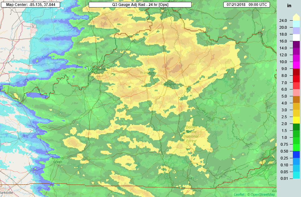
Rain Reports
Environment
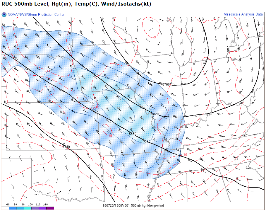
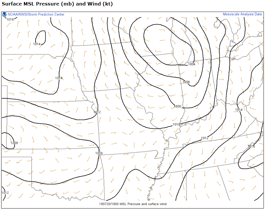
A very strong, anomalous upper level low brought multiple rounds of severe weather to the region.
 |
 |
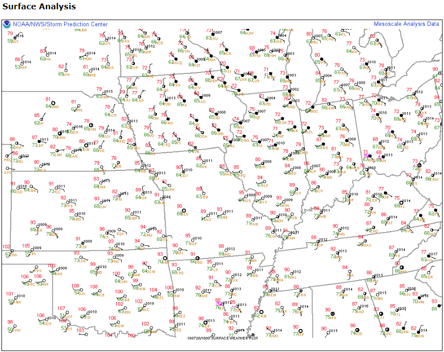 |
| Figure 1: 500mb analysis at 18z (7/20) | Figure 2: MSLP and surface winds (7/20) | Figure 3: Surface observations at 18z (7/20) |
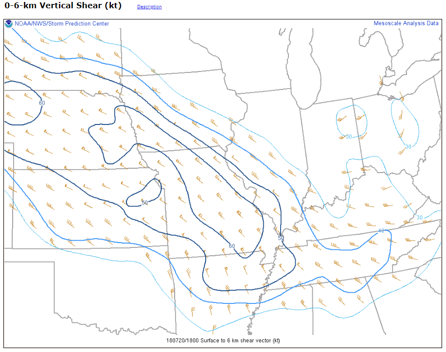
Afternoon storm environment.
 |
 |
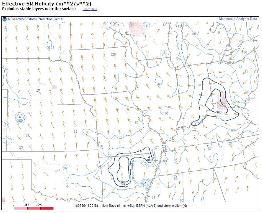 |
| Figure 4: SBCAPE at 18z (7/20) | Figure 5: 0-6km bulk shear at 18z (7/20) | Figure 6: ESRH at 18z (7/20) |
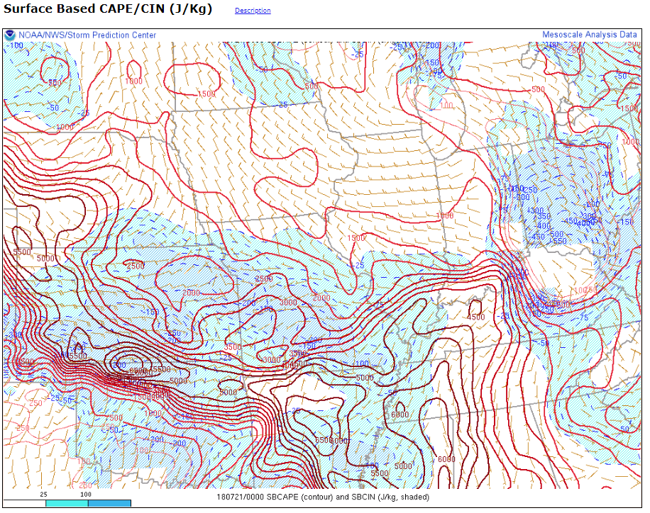
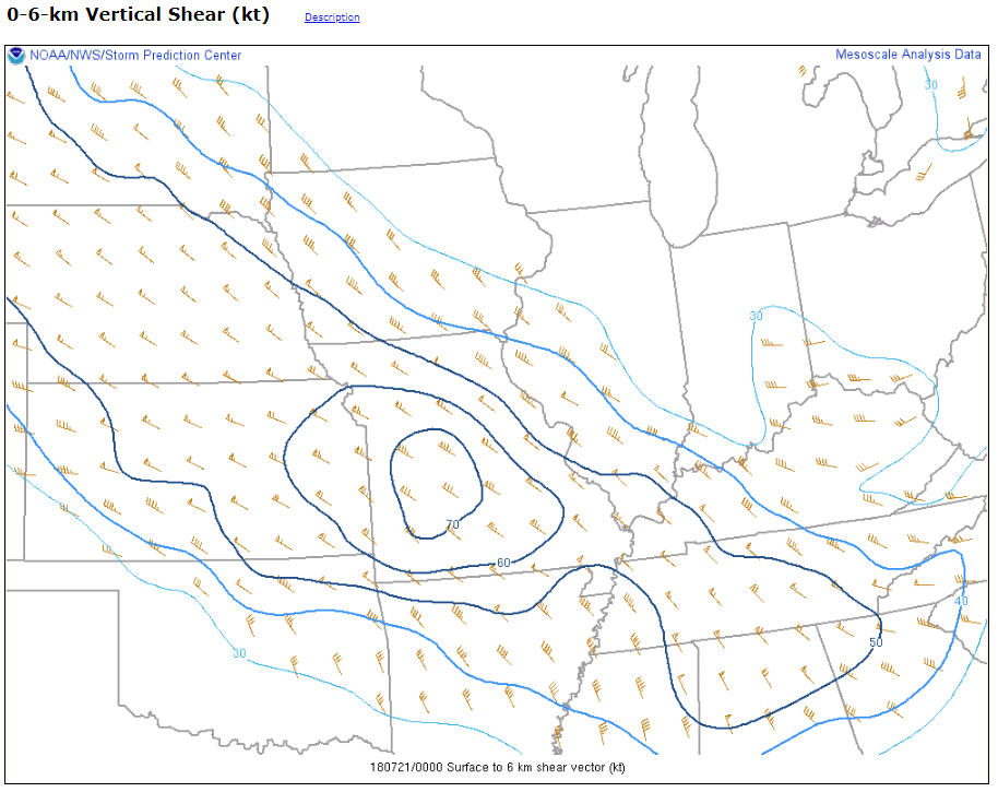
Evening/Overnight storm environment.
 |
 |
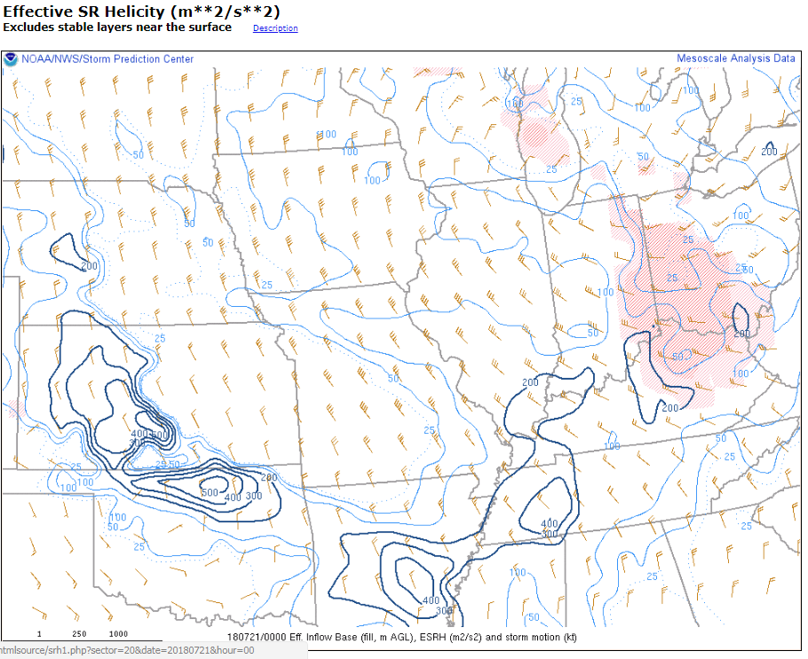 |
| Figure 7: SBCAPE at 00z (7/21) | Figure 8: 0-6km bulk shear at 00z (7/21) | Figure 9: ESRH at 00z (7/21) |
Other
 |
Media use of NWS Web News Stories is encouraged! Please acknowledge the NWS as the source of any news information accessed from this site. |
|


 Weather Story
 Weather Map
 Local Radar