Overview
|
A cold front approached the region on the afternoon and evening of Sunday July 2. Ahead of the front, a moist and unstable airmass combined with fairly strong wind shear aloft for this time of year. Numerous showers and thunderstorms developed in this airmass, including some supercell structures. Overall, two EF- 1 tornadoes touched down across central and east central Kentucky, as well as numerous wind damage reports across the area. A few instances of large hail up to the size of golf balls were also reported. This webpage is under construction, so check back frequently for updates. |
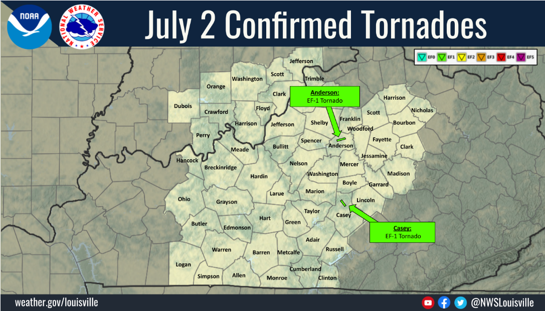 Two NWS Louisville damage surveys were conducted after the July 2, 2023 storms. Results of the surveys found two EF-1 tornadoes touched down across east central KY, in addition to numerous reports of wind damage across the region. |
Tornadoes:
Interactive Damage Survey Map - Zoom in and click the points to see damage information and pictures. All damage points are preliminary at this time. Performance of this map may be slow due to heavy internet traffic. **Zoom in to see very small, brief tornadoes.**

|
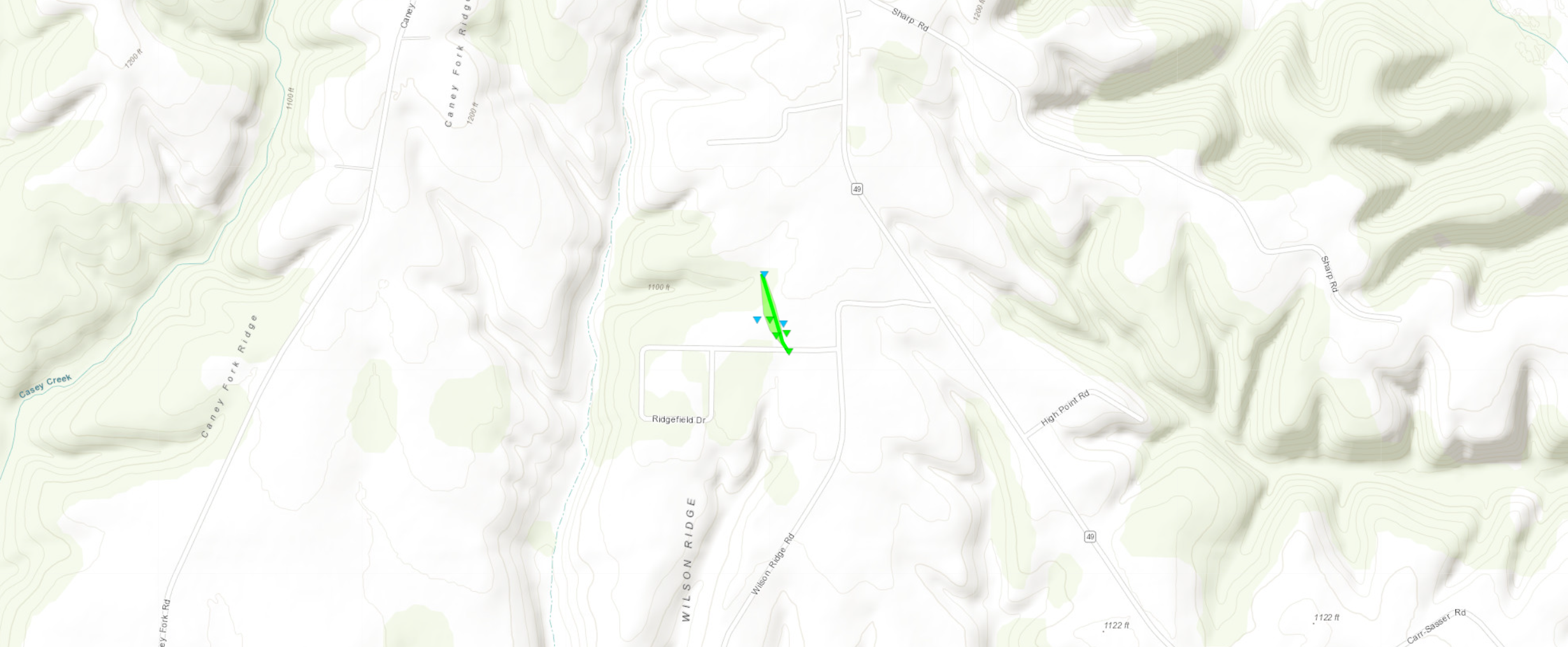
Tornado - Beech Bottom EF-1
Track Map
|
||||||||||||||||||
|
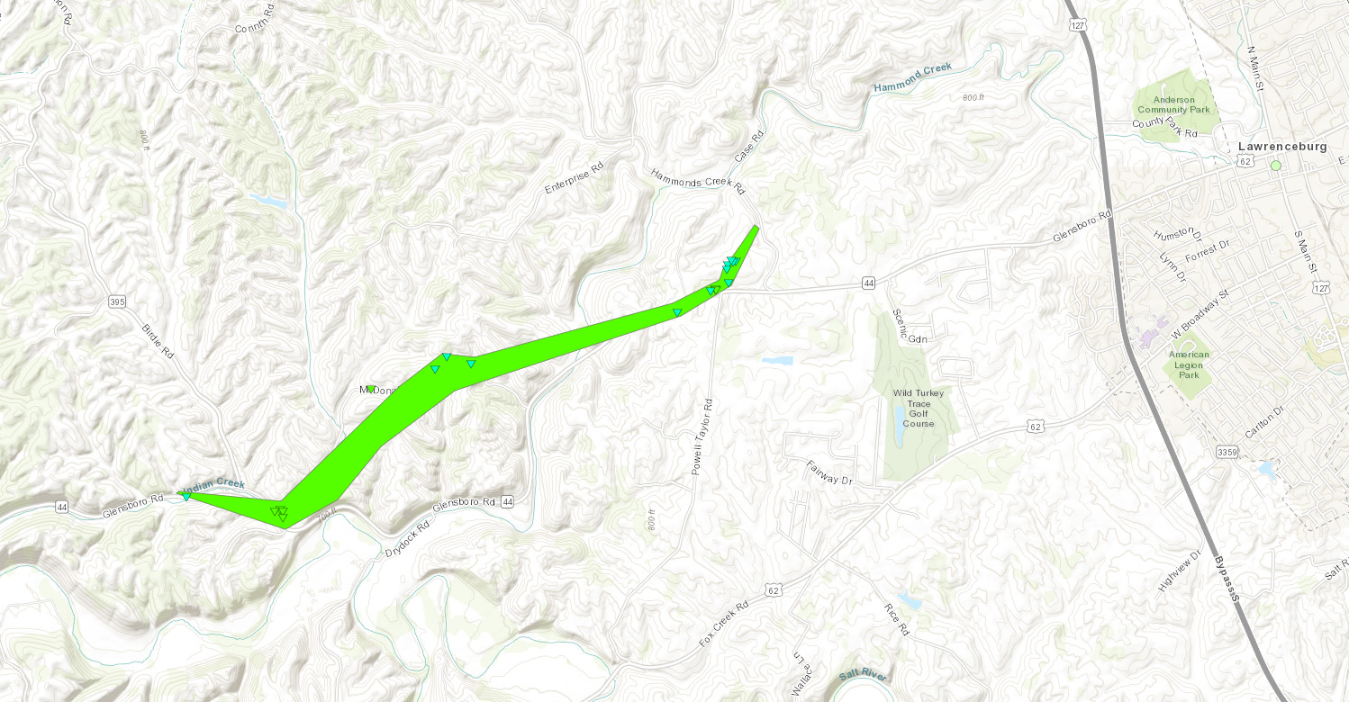
Tornado - Anderson City EF-1
Track Map
|
||||||||||||||||||
The Enhanced Fujita (EF) Scale classifies tornadoes into the following categories:
| EF0 Weak 65-85 mph |
EF1 Moderate 86-110 mph |
EF2 Significant 111-135 mph |
EF3 Severe 136-165 mph |
EF4 Extreme 166-200 mph |
EF5 Catastrophic 200+ mph |
 |
|||||
Radar Imagery
 |
 |
 |
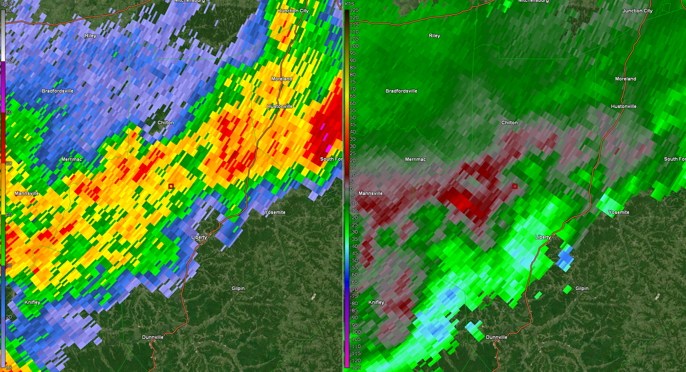 |
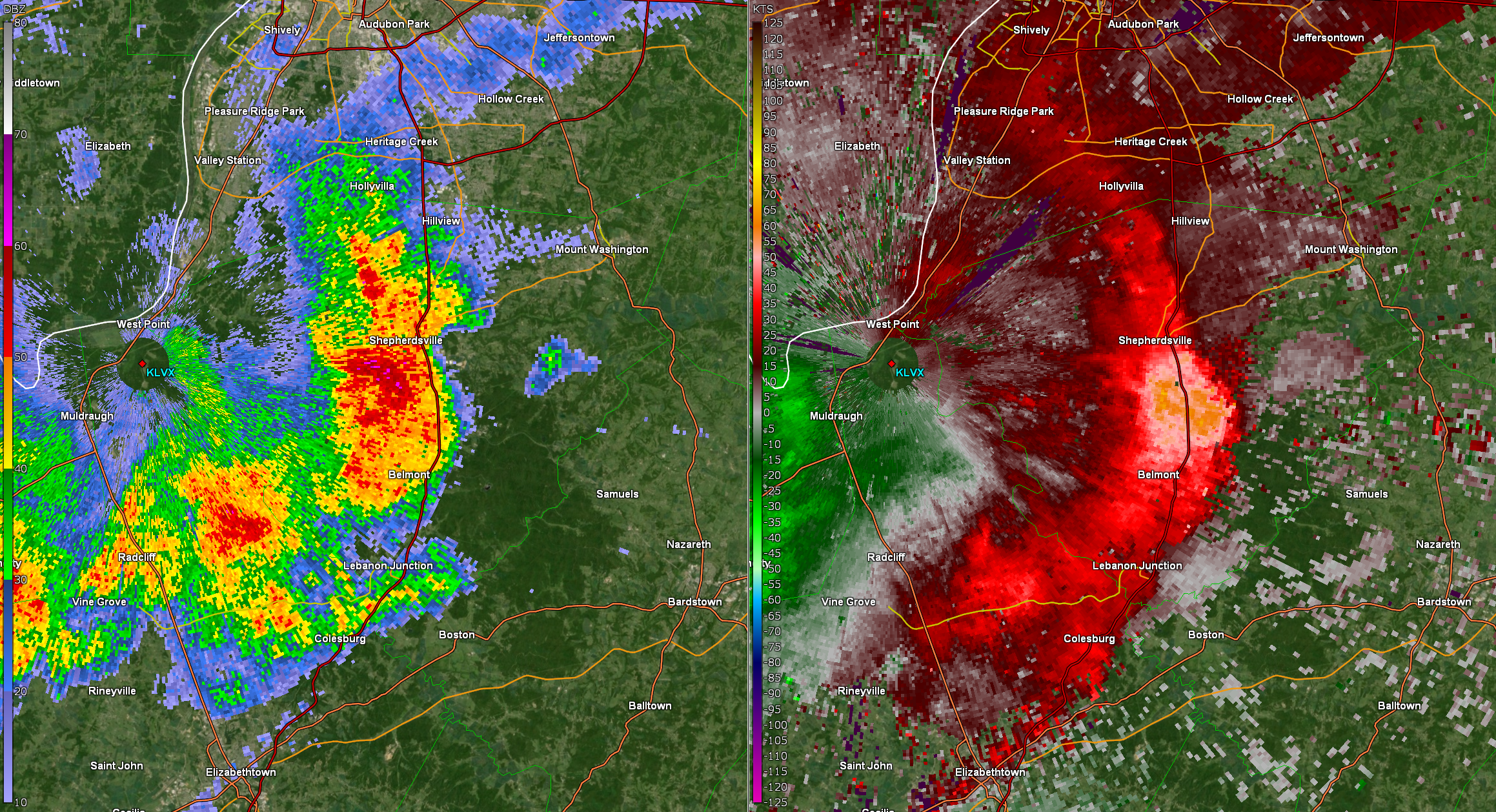
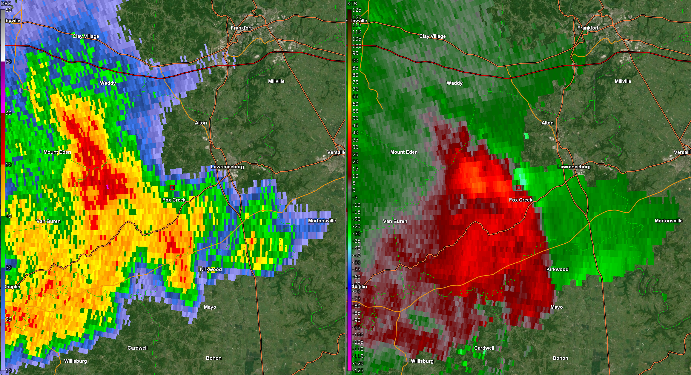
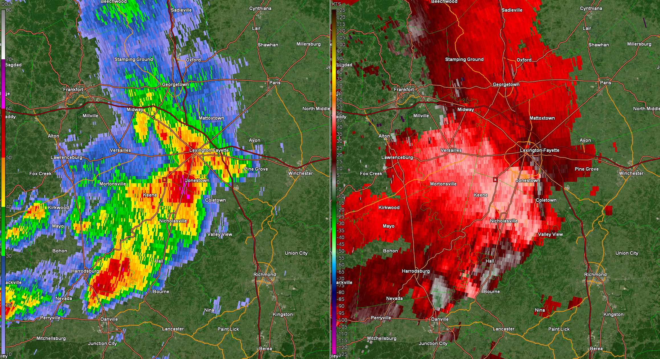
| KLVX Base Reflectivity (left) and Velocity (right) at 3:04 p.m. EDT for a storm moving through Bullitt County. Radar estimated wind speeds just south of Shepherdsville are between 70-75 mph at approximately 700 feet off the ground. Widespread tree and power line damage was reported from this storm. | KLVX Base Reflectivity (left) and Storm Relative Motion (right) at 3:56 p.m. EDT for a storm moving through Anderson County. At this time, an EF-1 tornado was ongoing west of Lawrenceburg, with the tornado's approximate position being represented by the red box on the image above. Winds moving toward the radar (west) are represented by green colors, while winds moving away from the radar (east) are represented by red colors. | KLVX Base Reflectivity (left) and Velocity (right) at 4:31 p.m. EDT for a storm moving through the Lexington metro. The "reverse C"/"bowing" shape of these storms are a good indicator for strong or severe winds, and many reports of wind damage were received from Lexington and Fayette County around this time. While radar velocity estimates winds between 60-70 mph from this storm, the LVX radar beam is 5000-6000 feet off the ground over this area, making surface wind estimates less reliable. | KLVX Base Reflectivity (left) and Storm Relative Motion (right) at 7:55 p.m. EDT for a storm moving through Casey County. A very brief EF-1 tornado tracked just northwest of Liberty around this time, with the estimated position of the tornado being represented by a red box in the image above. |
Storm Reports
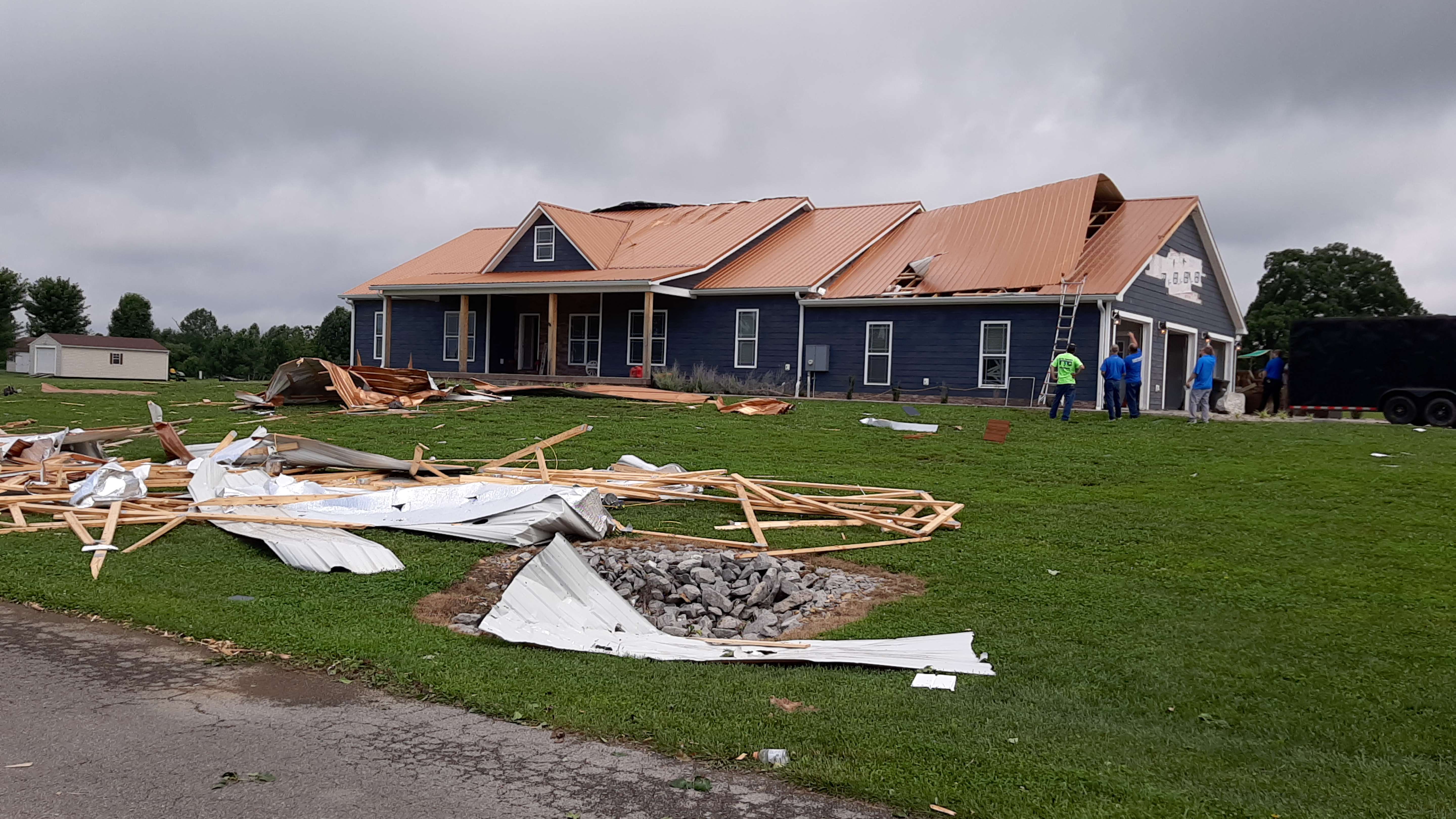
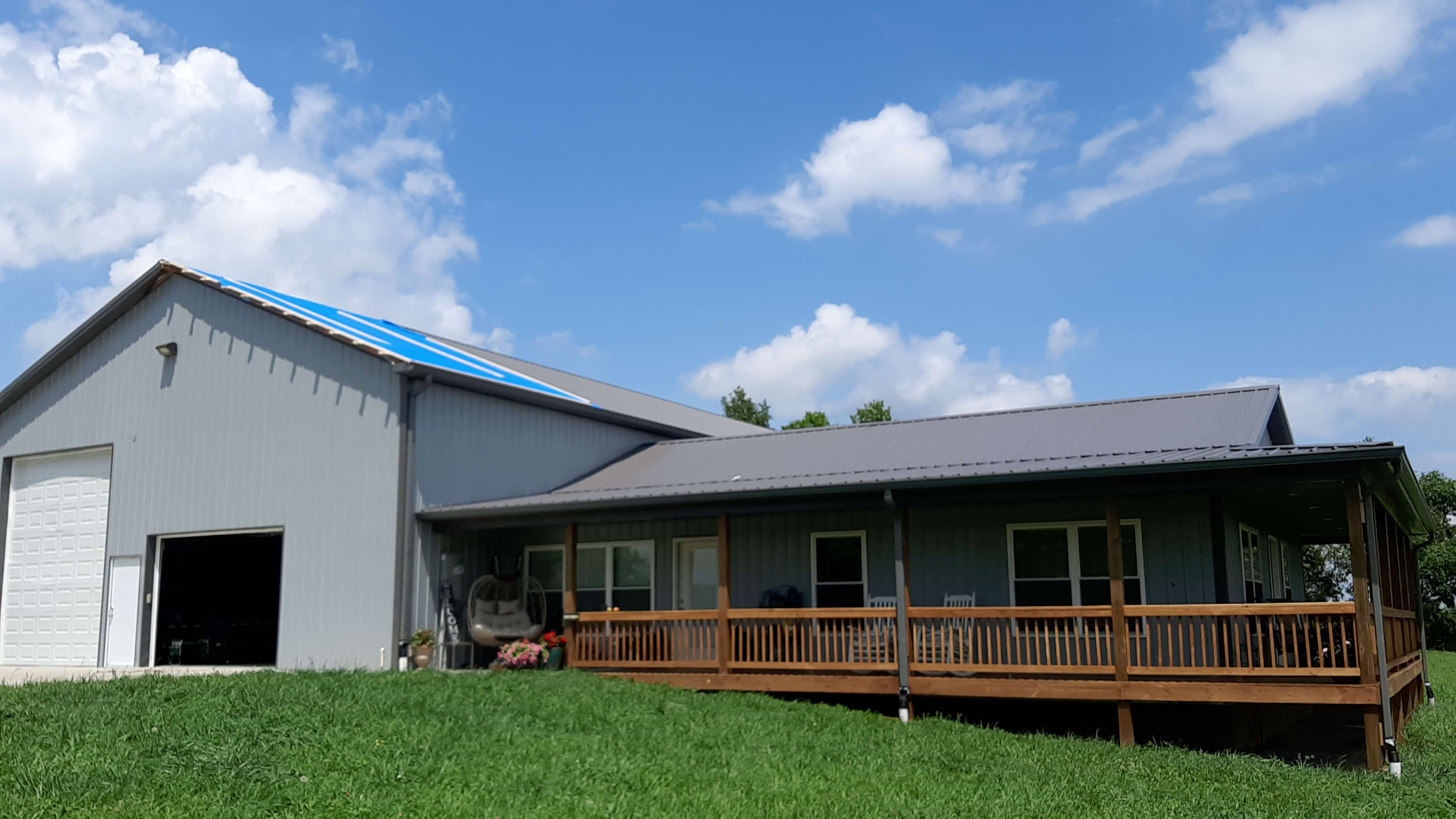
Preliminary Local Storm Report...Summary
National Weather Service Louisville KY
828 AM EDT Tue Jul 4 2023

..TIME...   ...EVENT...      ...CITY LOCATION...     ...LAT.LON...
..DATE...   ....MAG....      ..COUNTY LOCATION..ST.. ...SOURCE....
            ..REMARKS..

0414 PM     Tstm Wnd Dmg     Versailles              38.05N 84.73W
07/02/2023                   Woodford           KY   Emergency Mngr

            Trees down over roads.

0416 PM     Tstm Wnd Dmg     1 NNE Versailles        38.07N 84.73W
07/02/2023                   Woodford           KY   Public

            Tree down on Magnolia Circle.

0416 PM     Tstm Wnd Dmg     2 SE Versailles         38.04N 84.71W
07/02/2023                   Woodford           KY   Public

            Tree down near Huntertown road.

0418 PM     Tstm Wnd Dmg     Versailles              38.05N 84.73W
07/02/2023                   Woodford           KY   Trained Spotter

            Tree down.

0418 PM     Tstm Wnd Dmg     Midway                  38.15N 84.68W
07/02/2023                   Woodford           KY   Emergency Mngr

            Power pole down on Midway Road.

0426 PM     Tstm Wnd Dmg     1 NNE Versailles        38.07N 84.72W
07/02/2023                   Woodford           KY   Public

            Multiple trees down.

0434 PM     Tstm Wnd Dmg     3 S Midway              38.10N 84.69W
07/02/2023                   Woodford           KY   Public

            Tree down on road.

0405 PM     Tstm Wnd Dmg     1 N Willisburg          37.82N 85.12W
07/02/2023                   Washington         KY   911 Call Center

            Tree down over Chaplin Road.

0415 PM     Tstm Wnd Dmg     4 NE Mackville          37.78N 85.03W
07/02/2023                   Washington         KY   911 Call Center

            Tree down over road and dime sized hail.

0340 PM     Tstm Wnd Dmg     Taylorsville            38.03N 85.34W
07/02/2023                   Spencer            KY   911 Call Center

            Trees down over road.

0340 PM     Hail             Wakefield               37.97N 85.31W
07/02/2023  E1.00 inch       Spencer            KY   911 Call Center


0340 PM     Tstm Wnd Dmg     3 SSE Taylorsville      38.00N 85.33W
07/02/2023                   Spencer            KY   911 Call Center

            Roof blown off a barn near Bloomfield Rd.

0347 PM     Tstm Wnd Dmg     Chaplin                 37.90N 85.22W
07/02/2023                   Nelson             KY   911 Call Center

            Trees and powerlines down.

0440 PM     Tstm Wnd Dmg     2 E Burgin              37.75N 84.73W
07/02/2023                   Mercer             KY   Public

            Tree down on Normans Camp Road.

0230 PM     Tstm Wnd Dmg     Ekron                   37.93N 86.18W
07/02/2023                   Meade              KY   911 Call Center

            Trees down on powerline.

0246 PM     Tstm Wnd Dmg     2 SE Garrett            37.88N 86.10W
07/02/2023                   Meade              KY   911 Call Center

            Tree down over road.

0342 PM     Tstm Wnd Dmg     2 S Brandenburg         37.96N 86.18W
07/02/2023                   Meade              KY   Amateur Radio

            Trees down over Old State Road.

0350 PM     Tstm Wnd Dmg     2 NNE Ekron             37.96N 86.17W
07/02/2023                   Meade              KY   Public

            Multiple trees down.

0354 PM     Tstm Wnd Dmg     1 NE Ekron              37.94N 86.17W
07/02/2023                   Meade              KY   Emergency Mngr

            Emergency manager sent in a picture of a
            metal carport wrapped around a large tree
            that has been blown over and on the ground.

0721 PM     Tstm Wnd Dmg     1 NE Moreland           37.51N 84.81W
07/02/2023                   Lincoln            KY   Emergency Mngr

            Tree down over road.

0754 PM     Tstm Wnd Dmg     Crab Orchard            37.46N 84.51W
07/02/2023                   Lincoln            KY   Trained Spotter

            Trees down.

0145 PM     Hail             2 E Pellville           37.76N 86.78W
07/02/2023  E1.00 inch       Hancock            KY   Public

            Report from mPING: Quarter (1.00 in.).

0148 PM     Tstm Wnd Dmg     2 NNW Lyonia            37.75N 86.75W
07/02/2023                   Hancock            KY   Public

            Tree down on Bates Hollow Road.

0218 PM     Hail             3 ESE Lyonia            37.69N 86.68W
07/02/2023  E1.75 inch       Hancock            KY   911 Call Center


0458 PM     Hail             5 NW Hawesville         37.95N 86.82W
07/02/2023  E1.00 inch       Hancock            KY   Public


0728 PM     Tstm Wnd Dmg     3 WNW Black Gnat        37.33N 85.50W
07/02/2023                   Green              KY   Trained Spotter

            Damage to barn roof on Marshall Ridge Road.

0738 PM     Tstm Wnd Dmg     1 NW Greensburg         37.27N 85.51W
07/02/2023                   Green              KY   Emergency Mngr

            Tree down on Hidden Valley Road.

0739 PM     Tstm Wnd Dmg     Greensburg              37.26N 85.49W
07/02/2023                   Green              KY   Emergency Mngr

            Tree down on Russell Ave.

0424 PM     Tstm Wnd Dmg     5 SSW Lexington         37.99N 84.54W
07/02/2023                   Fayette            KY   Trained Spotter

            Walnut tree snapped.

0428 PM     Tstm Wnd Dmg     6 SSW Lexington         37.97N 84.53W
07/02/2023                   Fayette            KY   Broadcast Media

            Trees down on Nicholasville Rd.

0428 PM     Tstm Wnd Dmg     6 S Lexington           37.96N 84.50W
07/02/2023                   Fayette            KY   Broadcast Media

            Trees down on Tates Creek Rd.

0430 PM     Tstm Wnd Gst     6 W Lexington           38.04N 84.61W
07/02/2023  M59 MPH          Fayette            KY   ASOS


0430 PM     Tstm Wnd Dmg     5 S Lexington           37.98N 84.51W
07/02/2023                   Fayette            KY   Public

            Multiple trees down on road.

0432 PM     Tstm Wnd Dmg     Lexington               38.05N 84.50W
07/02/2023                   Fayette            KY   Trained Spotter

            Tree down in yard.

0432 PM     Tstm Wnd Dmg     4 SSW Lexington         37.98N 84.52W
07/02/2023                   Fayette            KY   Public

            Tree on road.

0433 PM     Tstm Wnd Dmg     5 SSW Lexington         37.98N 84.53W
07/02/2023                   Fayette            KY   Public

            Tree down near Nicholasville Road.

0435 PM     Tstm Wnd Dmg     6 NNW Spears            37.95N 84.48W
07/02/2023                   Fayette            KY   Public

            Tree down near Tates Creek Road.

0435 PM     Tstm Wnd Dmg     6 S Lexington           37.97N 84.48W
07/02/2023                   Fayette            KY   Public

            Tree down near Man O War Blvd.

0436 PM     Tstm Wnd Dmg     4 SSE Lexington         37.99N 84.46W
07/02/2023                   Fayette            KY   Public

            Uprooted tree.

0439 PM     Tstm Wnd Dmg     6 SE Lexington          38.00N 84.42W
07/02/2023                   Fayette            KY   Public

            Multiple trees down near Andover Hill.

0450 PM     Tstm Wnd Gst     6 SSW Lexington         37.96N 84.53W
07/02/2023  M56 MPH          Fayette            KY   Mesonet


0454 PM     Tstm Wnd Dmg     1 ESE Winchester        37.99N 84.18W
07/02/2023                   Clark              KY   911 Call Center

            Trees down over multiple roads.

0454 PM     Tstm Wnd Dmg     4 NNE Ford              37.94N 84.23W
07/02/2023                   Clark              KY   911 Call Center

            Multiple trees down.

0755 PM     Tornado          5 NNW Liberty           37.38N 84.98W
07/02/2023                   Casey              KY   NWS Storm Survey

            A very brief EF-1 tornado touched down off
            Highway 49 and Wilson Ridge Road in Casey
            county. The tornado had peak winds of 105
            mph, and a max path width of 40 yards, and
            was on the ground for less than 1 minute.
            The tornado did significant roof, porch, and
            siding damage to a home, as well as some
            tree damage upon touchdown. The homeowner
            gave a time just before 8 PM EDT.

0756 PM     Tstm Wnd Dmg     5 NNW Liberty           37.38N 84.97W
07/02/2023                   Casey              KY   Emergency Mngr

            Roof blown off home near intersection of
            Wilson Ridge Road and HWY 49.

0306 PM     Tstm Wnd Dmg     Bardstown Junction      37.94N 85.70W
07/02/2023                   Bullitt            KY   911 Call Center

            Multiple trees down.

0306 PM     Tstm Wnd Dmg     Shepherdsville          37.99N 85.72W
07/02/2023                   Bullitt            KY   Public

            Multiple trees and power lines down over the
            road.

0307 PM     Tstm Wnd Dmg     1 NNW Clermont          37.93N 85.65W
07/02/2023                   Bullitt            KY   Amateur Radio

            Tree on house.

0318 PM     Tstm Wnd Dmg     3 W Highgrove           37.97N 85.54W
07/02/2023                   Bullitt            KY   911 Call Center

            Trees down.

0129 PM     Hail             Cloverport              37.84N 86.63W
07/02/2023  E1.00 inch       Breckinridge       KY   Emergency Mngr


0355 PM     Tornado          4 ENE Glensboro         38.01N 85.00W
07/02/2023                   Anderson           KY   NWS Storm Survey

            An EF-1 tornado with peak winds of 100 MPH
            touched down along Highway 44 west of
            Lawrenceburg. The tornado was on the ground
            for a little of 3 miles, reached a max width
            of 400 yards, and caused structural damage
            as well as numerous trees either uprooted or
            snapped.

0358 PM     Tstm Wnd Dmg     Glensboro               38.00N 85.06W
07/02/2023                   Anderson           KY   County Official

            Tree fallen on car.

0402 PM     Tstm Wnd Dmg     3 N Salvisa             37.97N 84.87W
07/02/2023                   Anderson           KY   Public

            Tree down on HWY 127.

0404 PM     Tstm Wnd Dmg     3 W Lawrenceburg        38.03N 84.95W
07/02/2023                   Anderson           KY   Emergency Mngr

            Roof blown off building and multiple trees
            down near 1600 Glensboro Road.

0406 PM     Tstm Wnd Gst     Lawrenceburg            38.04N 84.90W
07/02/2023  M57 MPH          Anderson           KY   County Official


0406 PM     Tstm Wnd Dmg     3 WSW Lawrenceburg      38.02N 84.95W
07/02/2023                   Anderson           KY   Public

            Tree down near Glensboro Road.

0409 PM     Tstm Wnd Dmg     1 SSE Lawrenceburg      38.02N 84.89W
07/02/2023                   Anderson           KY   Public

            Tree down near South Main Street.

0410 PM     Tstm Wnd Dmg     3 SSE Lawrenceburg      37.99N 84.88W
07/02/2023                   Anderson           KY   Public

            Tree down near Harrodsburg Road.

0411 PM     Tstm Wnd Dmg     1 SE Tyrone             38.02N 84.84W
07/02/2023                   Anderson           KY   Public

            Treed down near Wildcat Road.

0245 PM     Tstm Wnd Dmg     Oriole                  38.17N 86.50W
07/02/2023                   Perry              IN   911 Call Center

            Trees down.

0453 PM     Tstm Wnd Dmg     Mt. Pleasant            38.12N 86.52W
07/02/2023                   Perry              IN   911 Call Center

            Trees down near Mt. Pleasant area.

0500 PM     Tstm Wnd Dmg     Derby                   38.03N 86.53W
07/02/2023                   Perry              IN   911 Call Center

            Trees down.

0259 PM     Tstm Wnd Dmg     Sulphur                 38.24N 86.47W
07/02/2023                   Crawford           IN   911 Call Center

            Tree down near Sulphur.

0318 PM     Tstm Wnd Dmg     1 NNE Marengo           38.38N 86.34W
07/02/2023                   Crawford           IN   911 Call Center

            Large tree limb down over road.
Environment
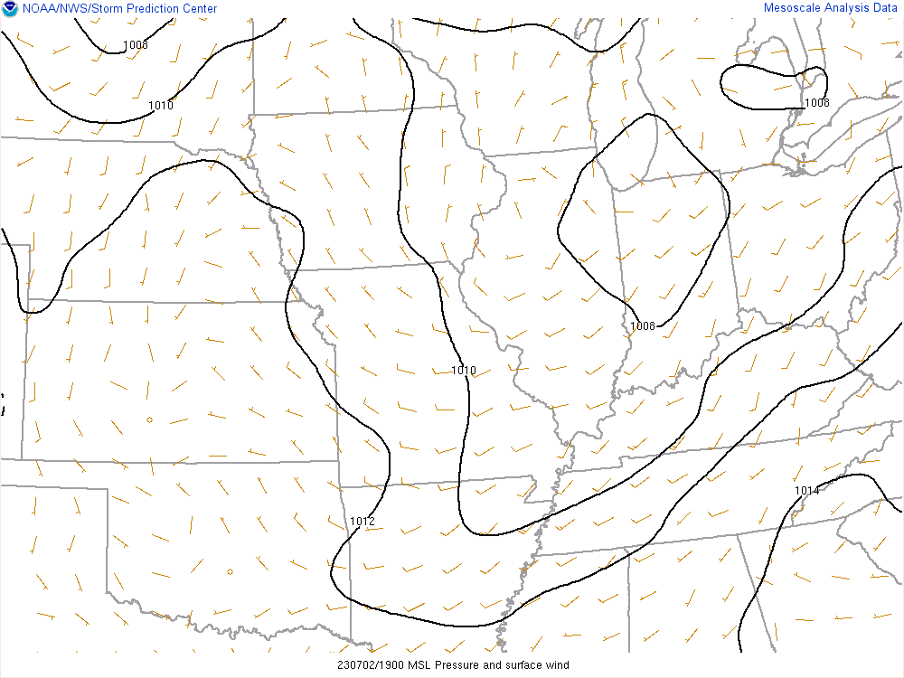
A strongly unstable airmass developed ahead of an approaching cold front on the afternoon and evening of Sunday July 2, 2023. In addition to the unstable atmosphere, strong shear for this time of year also developed, leading to the development of organized strong to severe storms. Some of the storms displayed supercell characteristics, including splitting supercells that veered to the right and left of the mean flow.
Environmental Parameters - 3 PM EDT
 |
.gif) |
 |
|
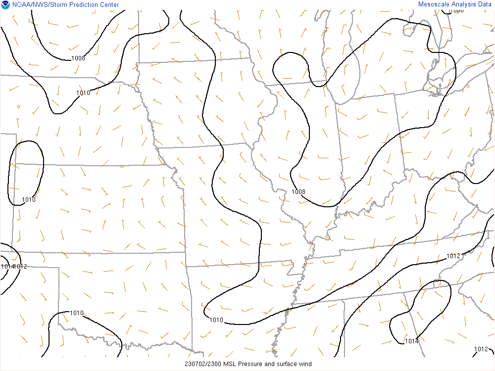
Figure 1: Mean Sea Level Pressure A weak surface low was position over the lower Great Lakes region, with a trailing cold front entering the Ohio River Valley from the west. |
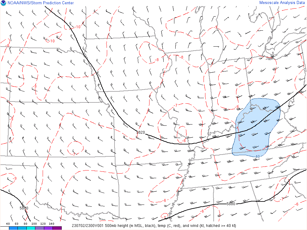
Figure 2: 500mb Heights/Isotachs A shortwave trough was entering the region, providing an enhancement in the deep layer wind shear, as well as upward vertical motion (triggering) for thunderstorm development. |
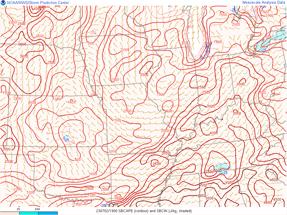
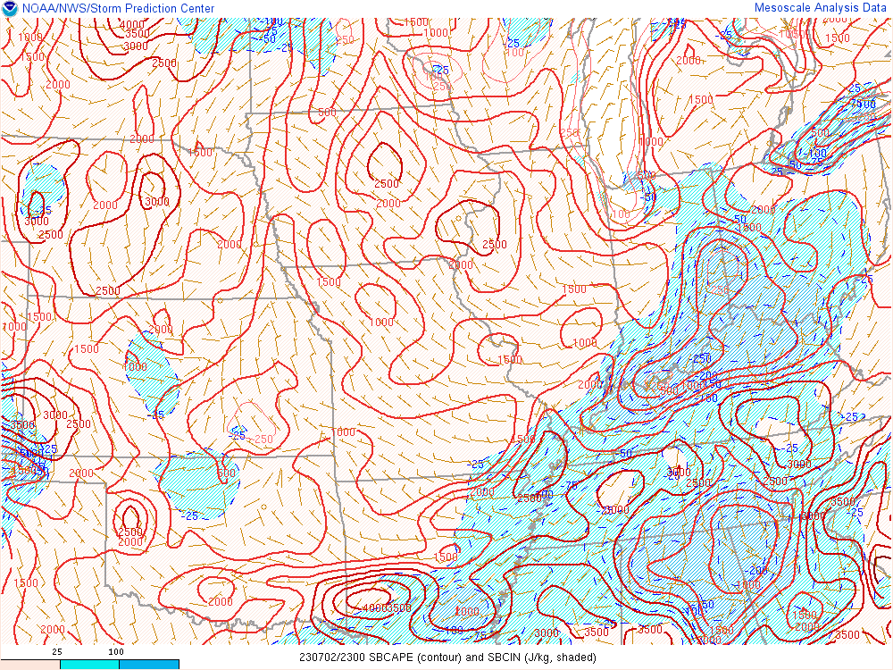
Figure 3: Surface Based CAPE 3000-4000 J/KG of surface based instability indicated a strongly unstable environment, capable of producing robust updrafts. Instability of this magnitude can lead to increase threats of large hail, damaging winds, and tornadoes in the presence of other critical environmental parameters. |
 |
 |
 |
|
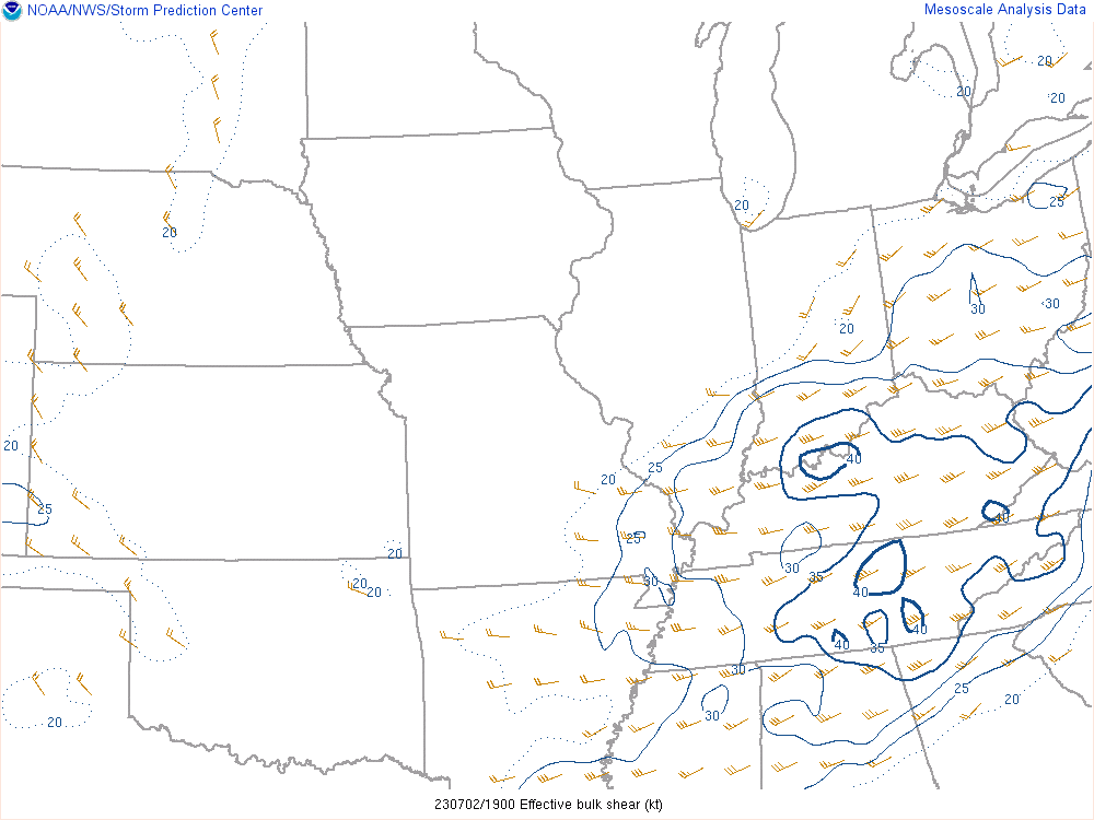
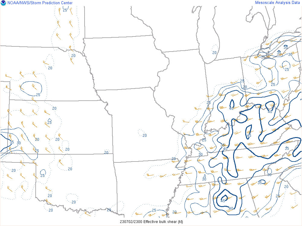
Figure 4: Effective Bulk Shear This parameter shows the amount of available wind shear that the storm was able to ingest from the bottom to the top of the storm. Values over 25 to 30 knots are usually sufficient for organized severe storms, including supercells. |
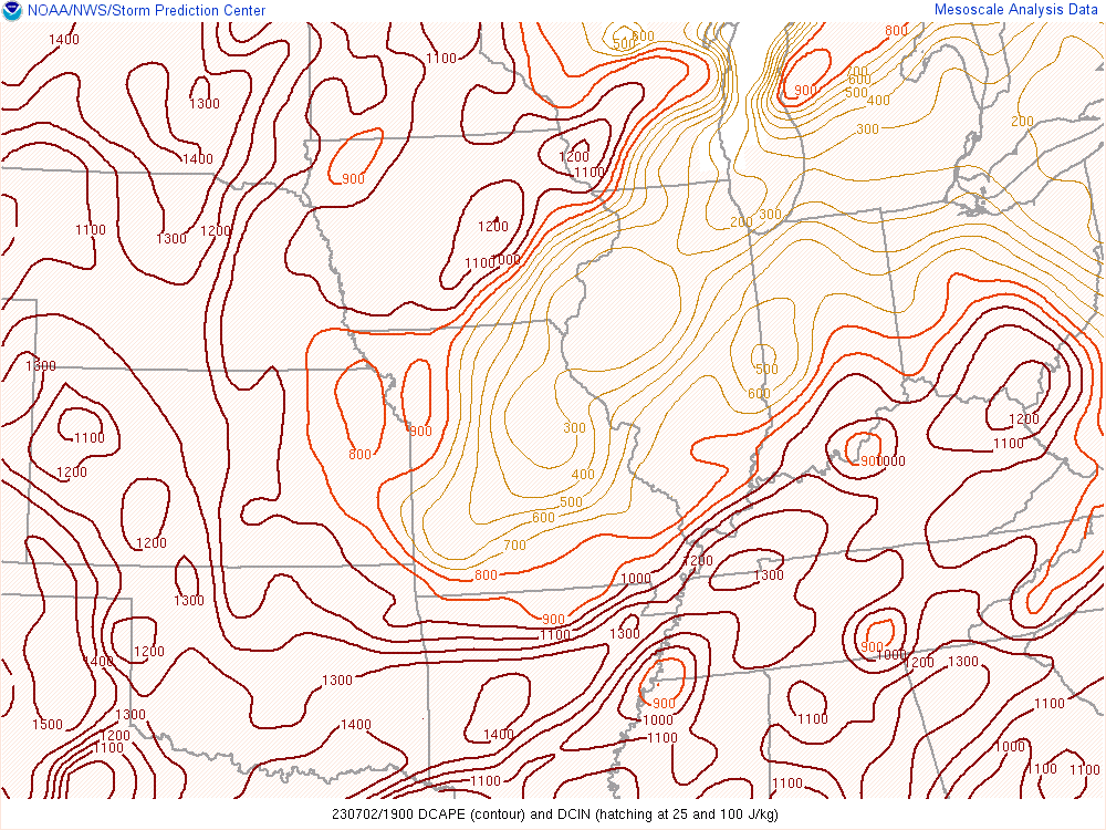
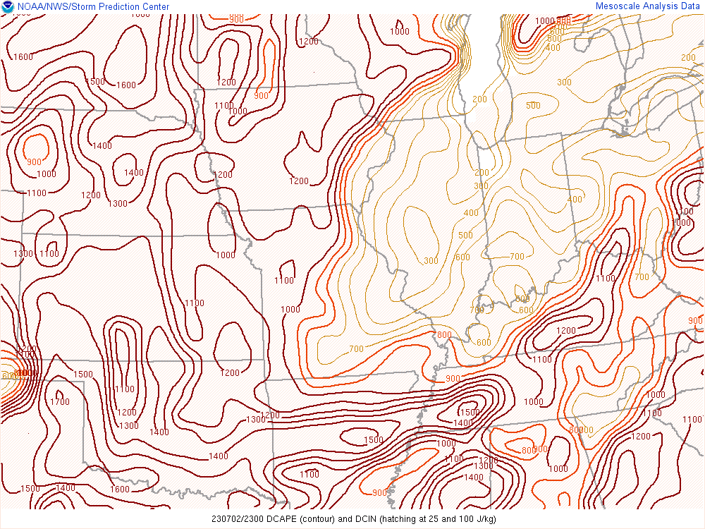
Figure 5: Downdraft CAPE Downdraft CAPE measures how much downward instability momentum a storm environment may have, which leads to increased damaging wind potential. In this case, values were well over 1000 J/KG which is very conducive to severe wind gusts from strong downdrafts. |
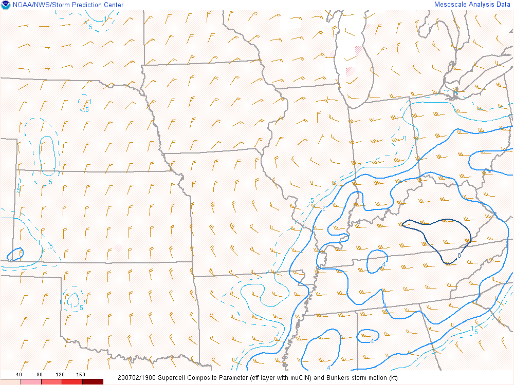
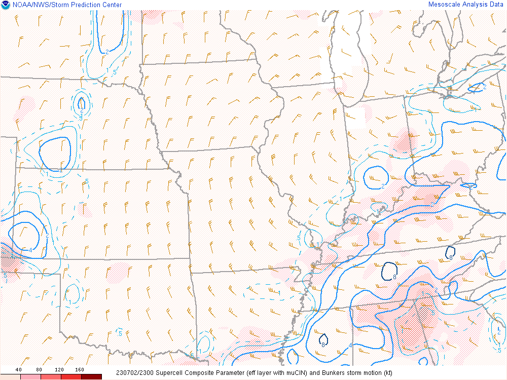
Figure 6: Supercell Composite Parameter This parameter was showing the potential for updrafts to rotate, which is the main driver for the supercell storm mode. The combination of sufficient deep layer shear (speed and directional), combined with an unstable atmosphere created the potential for supercells. |
The environment was very conducive to damaging winds, and instances of large hail with the strongest storms. However, the overall environment was not that favorable for tornadoes. In a couple of instances, local storm interactions and boundary ingestion likely contributed to brief enhanced tornado threats in Anderson and Casey counties.
Environmental Parameters - 7 PM EDT
 |
 |
 |
|
Figure 7: Mean Sea Level Pressure A weak surface continues to be positioned over the lower Great Lakes region, with the cold front now having progressed south and east of the Ohio River. |
Figure 8: 500mb Heights/Isotachs The shortwave trough continues to provide lift and enhanced deep layer shear across our region, allowing for continued support of organized strong to severe storms. |
Figure 9: Surface Based CAPE The environment remains strongly unstable, however a weak low level inversion has begun to set up with the loss of daytime heating. |
 |
 |
 |
|
Figure 10: Effective Bulk Shear Plenty of deep layer wind shear still exists for organized storm updrafts, adding to the potential for severe weather, including supercell storm modes in this case. |
Figure 11: Downdraft CAPE Downdraft CAPE remains strong south and east of the cold front. Damaging wind reports were continuing to occur where values were exceeding 1000 J/KG. |
Figure 12: Supercell Composite Parameter As evidenced by other parameters, the environment was still favorable for supercells, including some left and right moving storms. |
 |
Media use of NWS Web News Stories is encouraged! Please acknowledge the NWS as the source of any news information accessed from this site. |
|


.jpg)

 Weather Story
 Weather Map
 Local Radar