Louisville, KY
Weather Forecast Office
The Arctic Oscillation (AO) is a measure of the difference in pressures near the surface between the North Pole and 40 degrees latitude. When this index is very negative, as it is currently, indicated by the time series chart below, the Ohio Valley tends to have a better chance for measuring snowfall and colder temperatures. This contrast is more pronounced during a strong El Nino, as we also currently have.
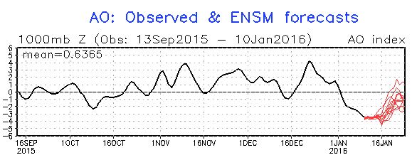
Note that for much of this cool season, the values has been near zero or positive (the black line on the plot above). Consequently, the region has not seen any measurable snowfall until now. Where the black line ends and the red lines begin are the forecast for the possible values of the AO based on model data. These forecasts are indicating the AO will stay negative at least for the next 7 days. Consequently our forecasts call for a couple of chances for measurable snowfall.
If you're interested in more study of these large-scale patterns check out this webpage from the Climate Prediction Center, http://www.cpc.ncep.noaa.gov/products/precip/CWlink/daily_ao_index/ao.shtml.
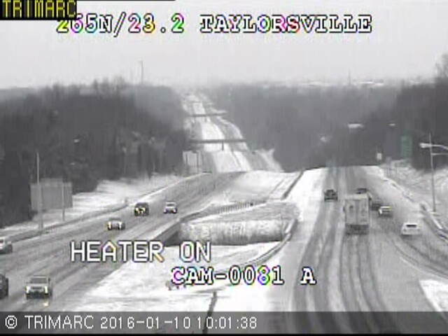
Louisville Trimarc Camera Image of potentially icy roads after morning snows along the Gene Snyder (I-265) and Taylorsville Road.
Current Hazards
Hazardous Weather Outlook
Storm Prediction Center
Submit a Storm Report
Advisory/Warning Criteria
Radar
Fort Knox
Evansville
Fort Campbell
Nashville
Jackson
Wilmington
Latest Forecasts
El Nino and La Nina
Climate Prediction
Central U.S. Weather Stories
1-Stop Winter Forecast
Aviation
IDSS Forecast Points
Air Quality
Fire Weather
Recreation Forecasts
1-Stop Drought
Event Ready
1-Stop Severe Forecast
Past Weather
Climate Graphs
1-Stop Climate
CoCoRaHS
Local Climate Pages
Tornado History
Past Derby/Oaks/Thunder Weather
Football Weather
Local Information
About the NWS
Forecast Discussion
Items of Interest
Spotter Training
Regional Weather Map
Decision Support Page
Text Products
Science and Technology
Outreach
LMK Warning Area
About Our Office
Station History
Hazardous Weather Outlook
Local Climate Page
Tornado Machine Plans
Weather Enterprise Resources
US Dept of Commerce
National Oceanic and Atmospheric Administration
National Weather Service
Louisville, KY
6201 Theiler Lane
Louisville, KY 40229-1476
502-969-8842
Comments? Questions? Please Contact Us.


 Weather Story
 Weather Map
 Local Radar