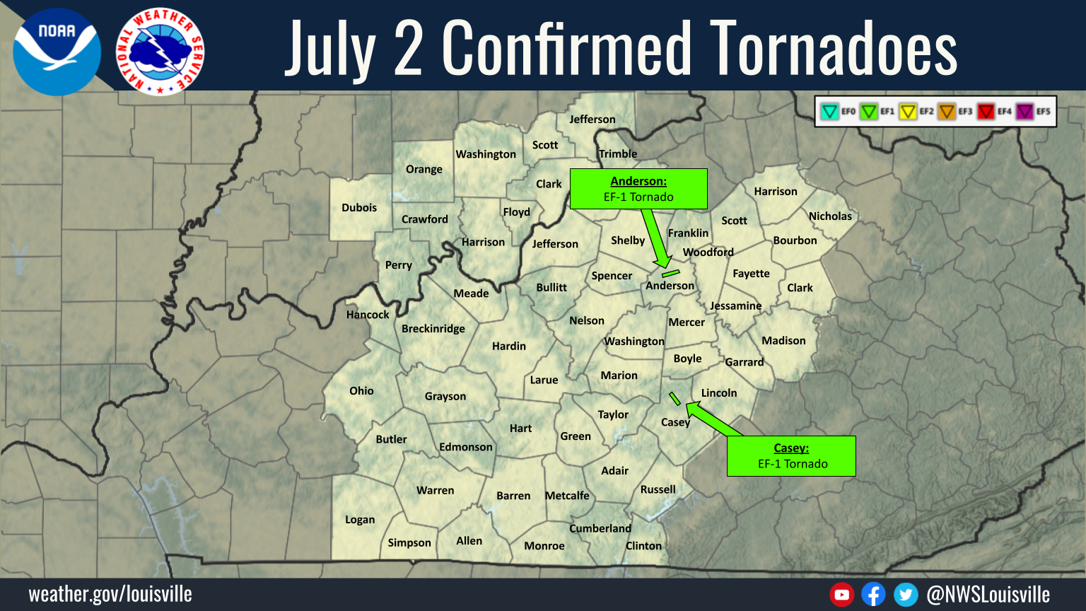
...NWS Damage Survey for 07/02/23 Tornado Event...

.Anderson County, Ky EF1 Tornado...

Rating:                 EF1
Estimated Peak Wind:    100 mph
Path Length /statute/:  3.3425 miles
Path Width /maximum/:   400.0 yards
Fatalities:             0
Injuries:               0

Start Date:             07/02/2023
Start Time:             03:55 PM EDT
Start Location:         1 ENE Anderson City / Anderson County /
KY
Start Lat/Lon:          38.0115 / -85.0005

End Date:               07/02/2023
End Time:               03:59 PM EDT
End Location:           3 WSW Lawrenceburg / Anderson County / KY
End Lat/Lon:            38.029 / -84.9478

Survey Summary:
Severe storms developed west of Lawrenceburg in two waves. One
produced straight line winds as a squall line and moved from west
to east into downtown Lawrenceburg where it caused multiple trees
to fall, likely with winds of 80-90 mph. Additionally, a brick
building downtown that had been previously damaged from the March
3rd event suffered additional damage to the brickwork.

The other was a storm that developed just south of that line and
caused a tornado to drop along Highway 44 west of Lawrenceburg
starting in the 2200 block where several large trees had fallen
along the road but had been cleaned up by the time the survey
occurred. There was significant tree damage along McDonald Road
paralleling Highway 44. The most significant damage occurred
around a square home with pyramid shaped roof. Trees fell without
hitting the home, but fell in multiple directions. No shingles
were damaged, but that may be due to the steepness of the roof.
The survey continued ENE with tree damage on both McDonald and
Highway 44 from the 2200 block all they way to the 1600 block. At
the latter location, a barndominium suffered partial roof damage.
Part of the metal roof was torn in one slab and thrown to the
east of the property. The property owner witnessed a circulation
approaching and took shelter in an open garage whose closed doors
were blown outwards. The tornado appeared to lift at this point
and merge with the main line heading towards Lawrenceburg.

The National Weather Service would like to thank Anderson County
Emergency Management for escorting us through the heaviest hit
areas.

&&

EF Scale: The Enhanced Fujita Scale classifies tornadoes into the
following categories:

EF0...Weak......65 to 85 mph
EF1...Weak......86 to 110 mph
EF2...Strong....111 to 135 mph
EF3...Strong....136 to 165 mph
EF4...Violent...166 to 200 mph
EF5...Violent...>200 mph

NOTE:
The information in this statement is preliminary and subject to
change pending final review of the event and publication in NWS
Storm Data.
...NWS Damage Survey for 07/02/2023 Tornado Event...

.Casey County, KY EF1 Tornado...

Rating:                 EF1
Estimated Peak Wind:    105 mph
Path Length /statute/:  0.1234 miles
Path Width /maximum/:   40.0 yards
Fatalities:             0
Injuries:               0

Start Date:             07/02/2023
Start Time:             07:55 PM EDT
Start Location:         2 W Beech Bottom / Casey County / KY
Start Lat/Lon:          37.3809 / -84.9794

End Date:               07/03/2023
End Time:               06:20 PM EDT
End Location:           2 W Beech Bottom / Casey County / KY
End Lat/Lon:            37.3792 / -84.9787

Survey Summary:
The National Weather Service conducted a storm survey of damage
to a property off of Wilson Ridge Road. There a well-built home
with a metal roof had its roof peeled off in the middle section
of the home. In that same area, an attached back porch awning was
also lifted and completely detached from the house. Some thick
siding was removed from the home as well. Damage in this area was
consistent with an EF-1 tornado with winds of 100-105 mph. The
homeowner stated the damage occurred a little before eight
o`clock, which is important given multiple storms moving across
the area over that hour. Time that the tornado was on the ground
was brief. Homeowner noted a small gap in the tree line north of
the house which we believe was the starting point. Damage went
downstream into a field of soybeans, but there was no apparent
path in the soybeans themselves.

We would like to thank the Casey County Emergency Management and
Kentucky Emergency Management (Area 10) for their assistance with
the survey.

&&

EF Scale: The Enhanced Fujita Scale classifies tornadoes into the
following categories:

EF0...Weak......65 to 85 mph
EF1...Weak......86 to 110 mph
EF2...Strong....111 to 135 mph
EF3...Strong....136 to 165 mph
EF4...Violent...166 to 200 mph
EF5...Violent...>200 mph

NOTE:
The information in this statement is preliminary and subject to
change pending final review of the event and publication in NWS
Storm Data.


 Weather Story
 Weather Map
 Local Radar