
Tropical Depression Nine is forecast to track toward the central U.S. Gulf Coast while strengthening into a tropical storm by early Wednesday and a hurricane on Thursday. Stay tuned to forecast updates. Much higher than typical October temperatures will continue across much of California through midweek. Temperatures are forecast to gradually cool beginning Thursday in Coastal California. Read More >
Louisville, KY
Weather Forecast Office
What is a temperature inversion?
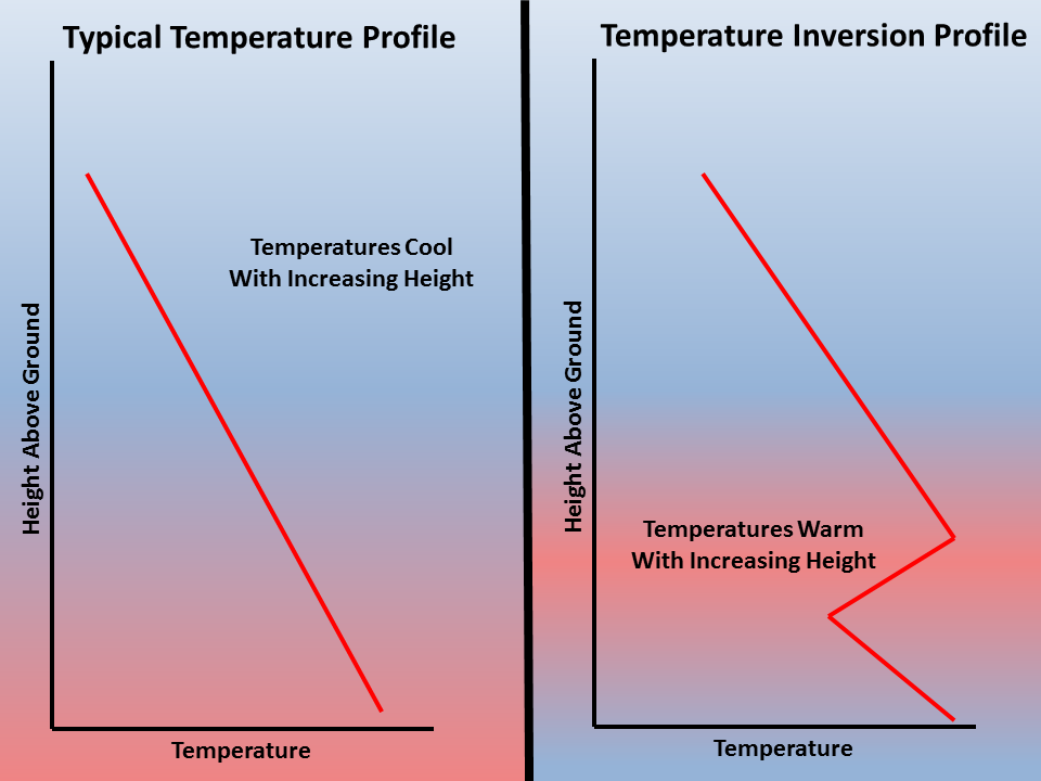
Typically, temperatures in the atmosphere cool with increasing altitude. This is due to the fact that the sun's energy is converted to sensible heat at the ground and warms the air at the surface. As this warm air rises, it cools and expands. However, in an inversion, the air temperature actually rises with height. When there is warm air on top of cooler air, meteorologists refer to this as an 'inversion' because the temperature profile is 'inverted' from its usual state. The image below illustrates this concept.
How do inversions develop?
Inversions are caused when warmer air is advected (moved) into the region where cooler air remains near the surface. Another method in which inversions develop is through the cooling of air near the ground at night. Once the sun goes down, the ground loses heat very quickly and this rapidly cools the air near the ground. However, since air is a poor conductor of heat, the air above the surface remains warm. Conditions that lead to this type of inversion are long night, clear skies and calm winds. The calm winds prevent that warmer air aloft from mixing down to the ground
How do inversions impact air quality?
Inversions can greatly impact air quality conditions throughout the year. The warm air aloft acts as a 'lid', which traps the colder air near the surface. Pollution and emissions from vehicles, industry, etc are then unable to escape the lowest levels of the atmosphere, which results in poor air quality. For the latest air quality conditions and forecast for your area, check out AirNow.
Current Hazards
Hazardous Weather Outlook
Storm Prediction Center
Submit a Storm Report
Advisory/Warning Criteria
Radar
Fort Knox
Evansville
Fort Campbell
Nashville
Jackson
Wilmington
Latest Forecasts
El Nino and La Nina
Climate Prediction
Central U.S. Weather Stories
1-Stop Winter Forecast
Aviation
IDSS Forecast Points
Air Quality
Fire Weather
Recreation Forecasts
1-Stop Drought
Event Ready
1-Stop Severe Forecast
Past Weather
Climate Graphs
1-Stop Climate
CoCoRaHS
Local Climate Pages
Tornado History
Past Derby/Oaks/Thunder Weather
Football Weather
Local Information
About the NWS
Forecast Discussion
Items of Interest
Spotter Training
Regional Weather Map
Decision Support Page
Text Products
Science and Technology
Outreach
LMK Warning Area
About Our Office
Station History
Hazardous Weather Outlook
Local Climate Page
Tornado Machine Plans
Weather Enterprise Resources

US Dept of Commerce
National Oceanic and Atmospheric Administration
National Weather Service
Louisville, KY
6201 Theiler Lane
Louisville, KY 40229-1476
502-969-8842
Comments? Questions? Please Contact Us.


 Weather Story
 Weather Map
 Local Radar
 Follow us on X
 Follow us on Facebook
 Follow us on YouTube
 LMK RSS Feed