Overview
A strong and deepening low pressure system moved across the Midwest Thursday and Thursday night March 25, 2021. As it did so it brought a warm front across Kentucky and Indiana during the daylight hours, with light to moderate rains. As we moved into the late afternoon and evening hours, strong winds above the surface helped to create an environment favoring spinning storms. In some cases this spinning allowed for large hail to grow and in others, some damaging wind gusts as well as tornadoes developed across central Kentucky.
Editor's note: This page will be updated as time and resources allow.
Tornadoes:
|
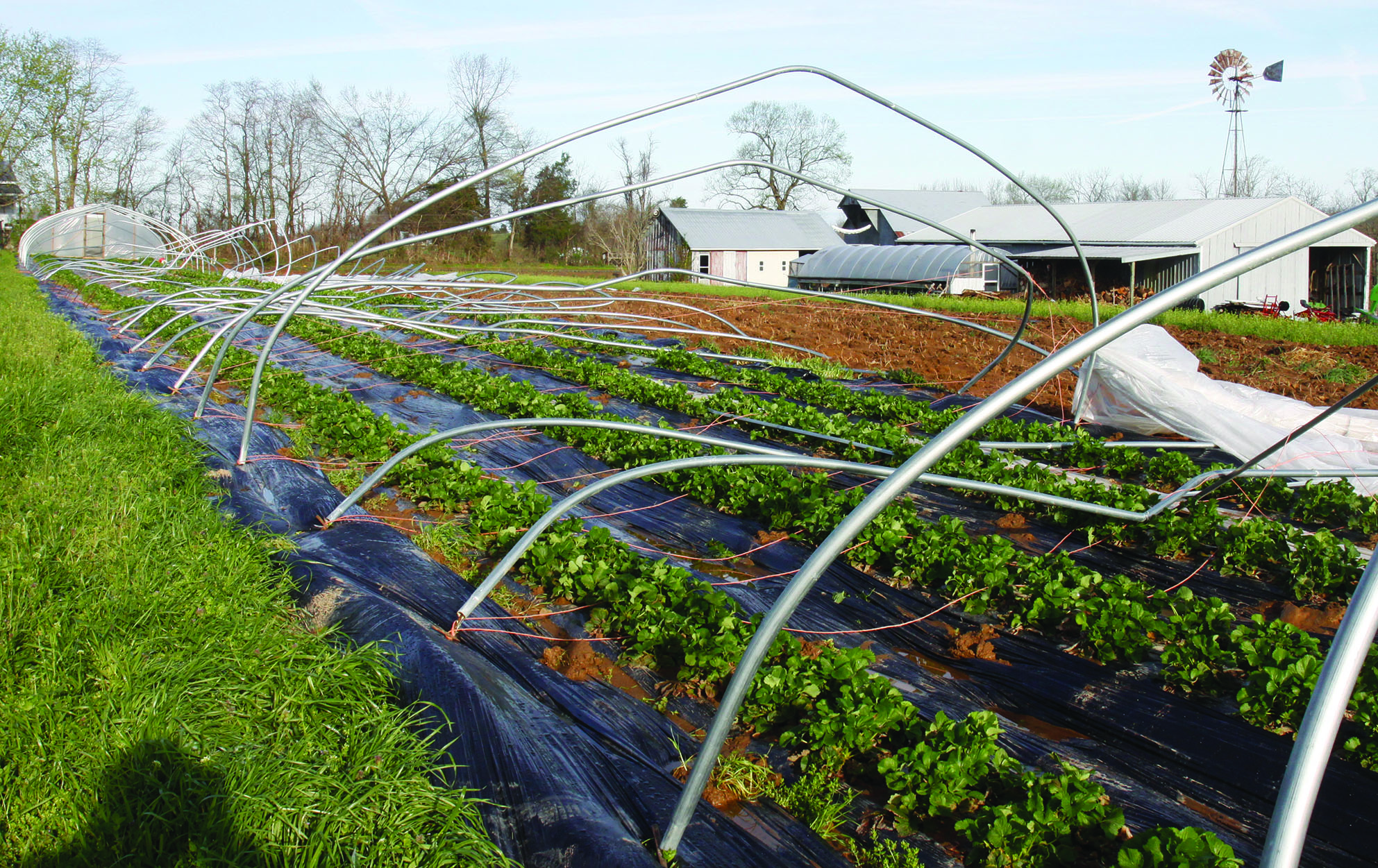
Tornado - HODGENVILLE
Track Map 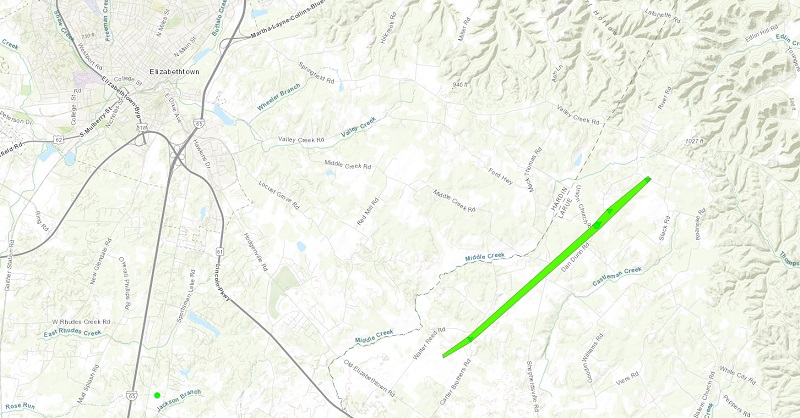 
Downloadable KMZ File |
||||||||||||||||
|
Tornado - CLARKSON
Track Map .jpg)
Downloadable KMZ File |
||||||||||||||||
|
Tornado - ROSINE
Track Map 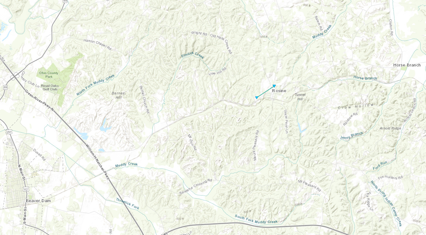
Downloadable KMZ File |
||||||||||||||||
The Enhanced Fujita (EF) Scale classifies tornadoes into the following categories:
| EF0 Weak 65-85 mph |
EF1 Moderate 86-110 mph |
EF2 Significant 111-135 mph |
EF3 Severe 136-165 mph |
EF4 Extreme 166-200 mph |
EF5 Catastrophic 200+ mph |
 |
|||||
Wind & Hail:
Wind
 |
 |
 |
|
Straight line wind damage in Allen County, KY (Photo Credits: Matt Pedigo) |
Straight line wind damage in Allen County, KY (Photo Credits: Matt Pedigo) |
Straight line wind damage in Allen County, KY (Photo Credits: Matt Pedigo) |
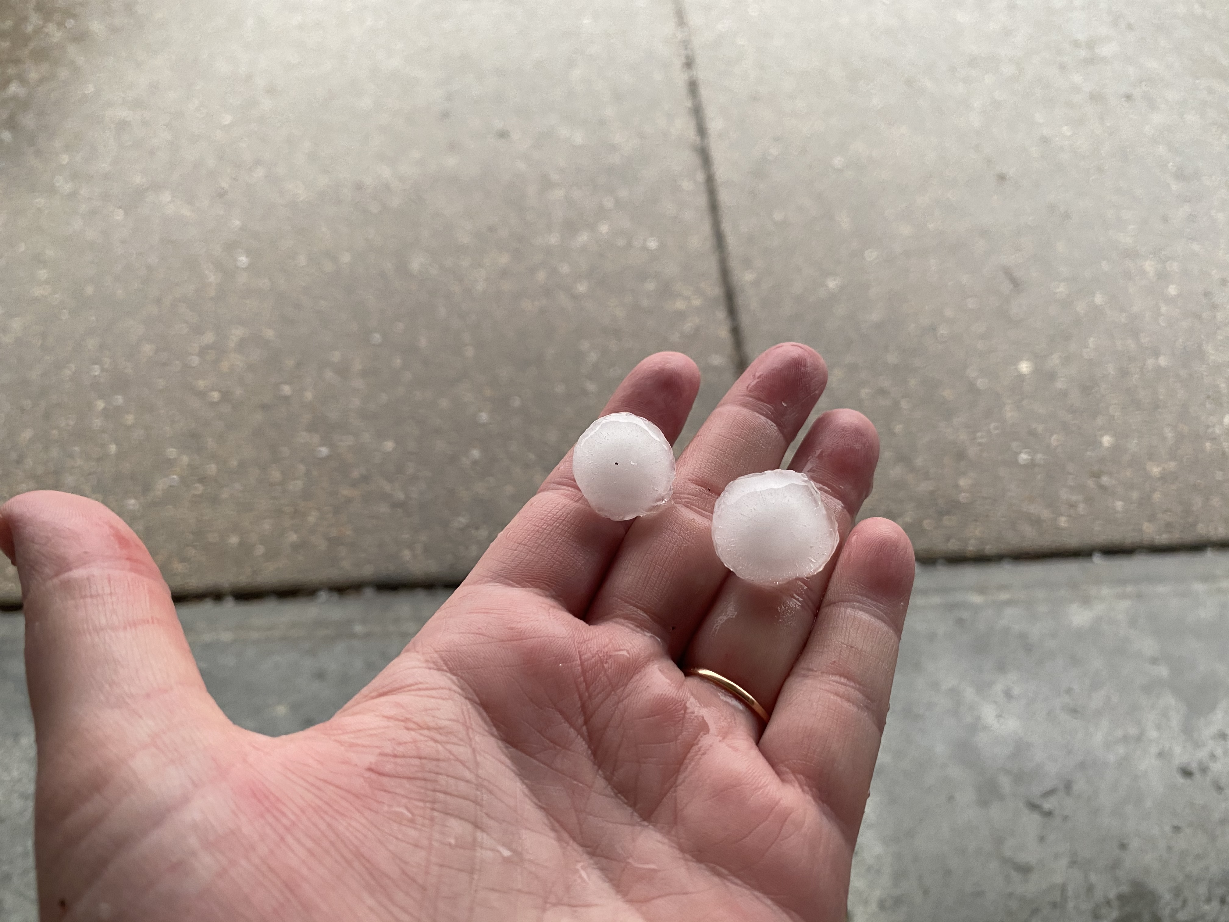
Hail
 |
|
Hailstones in Spencer County, KY (Photo Credits: Rebecca Goff) |
Photos & Video
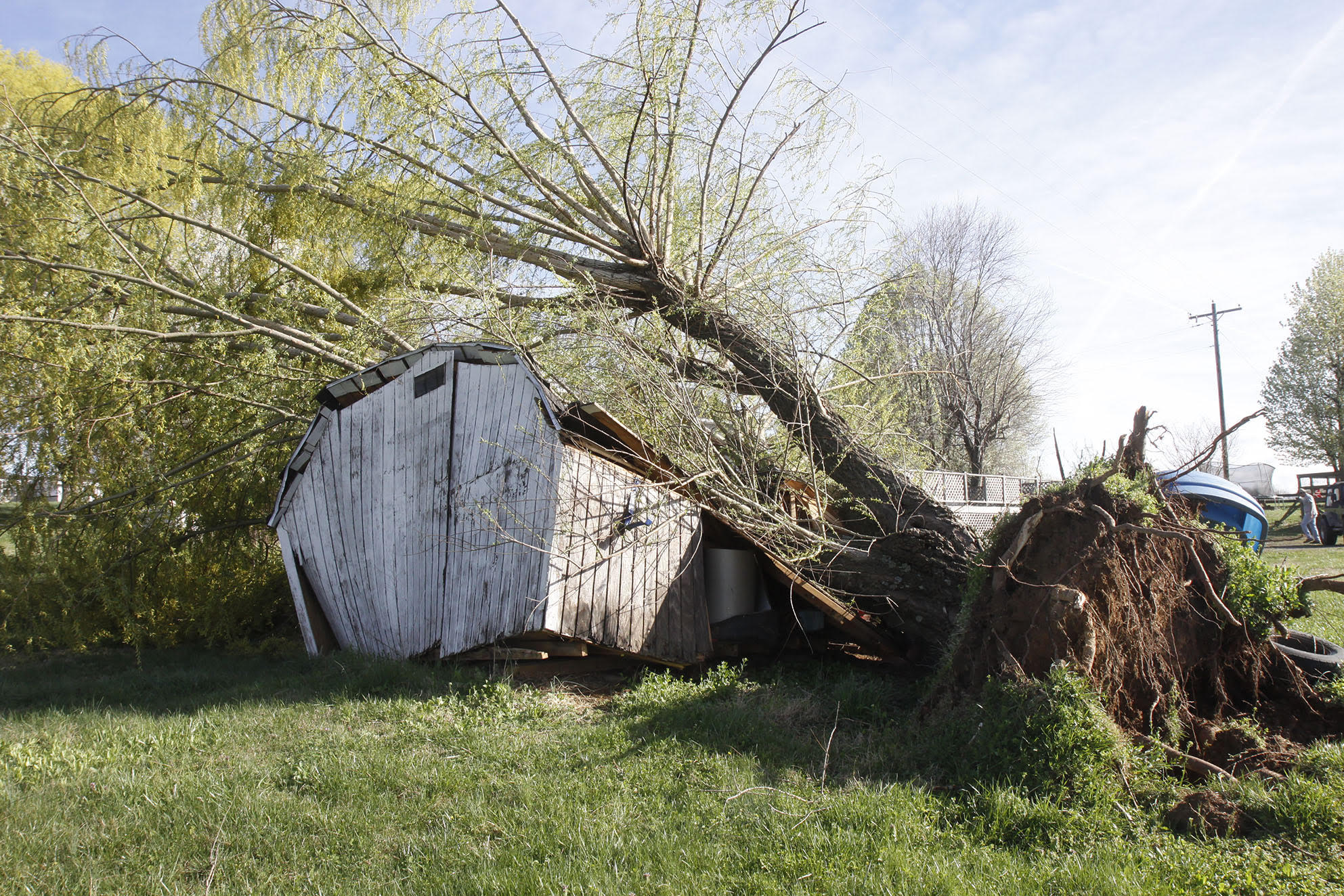
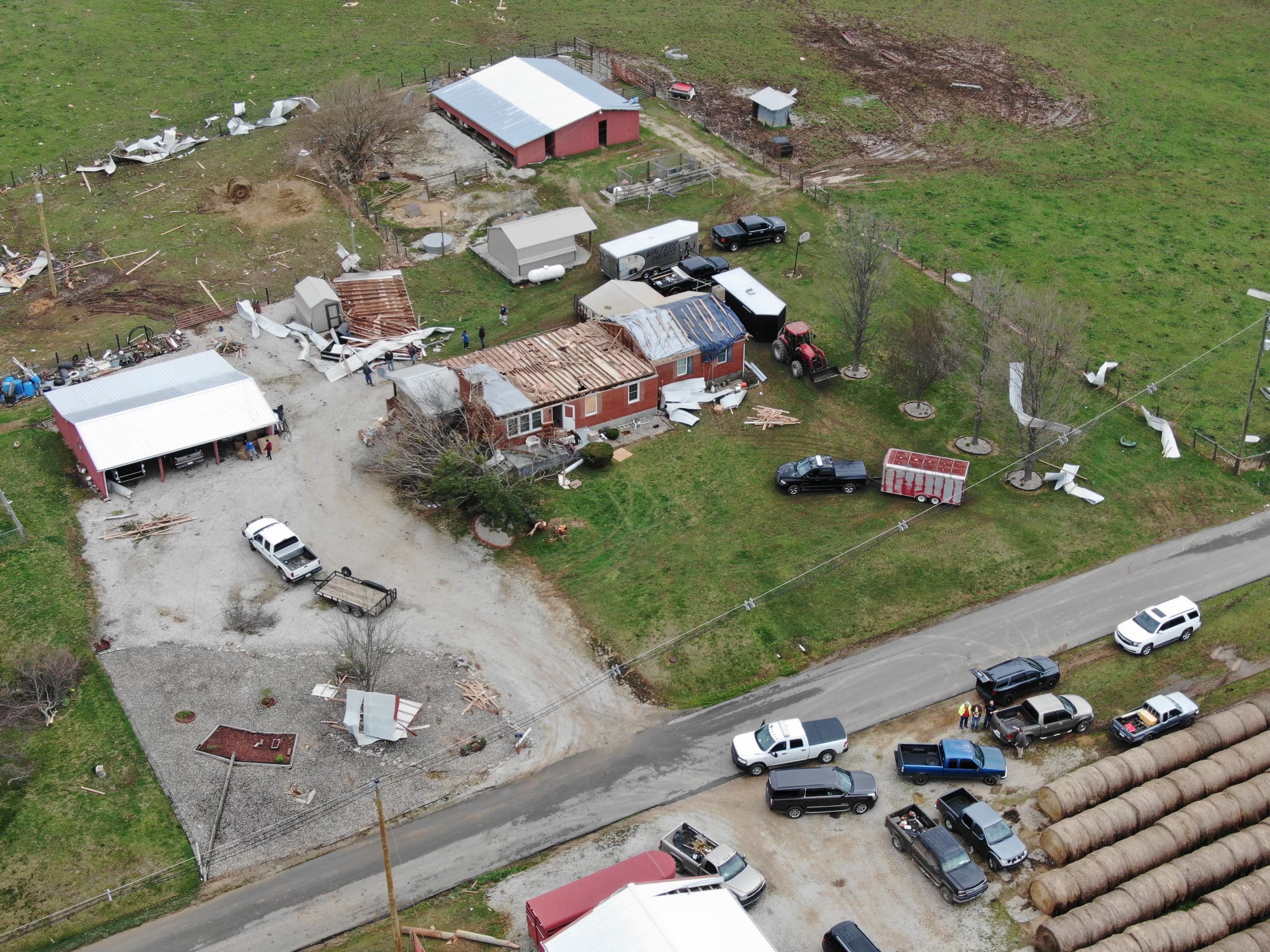
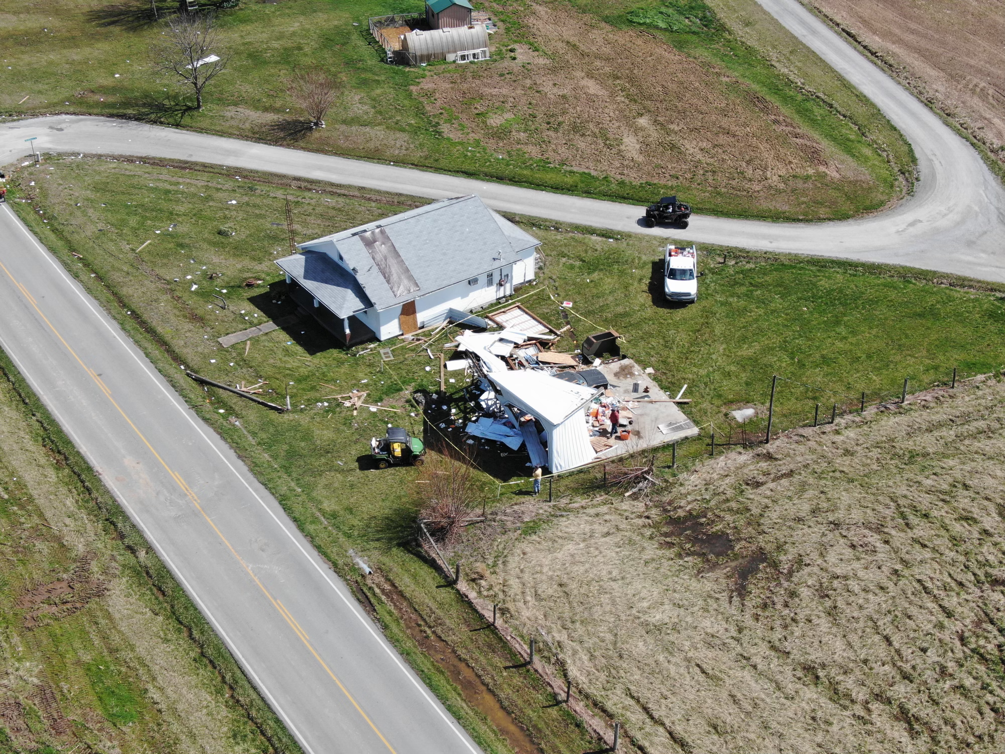
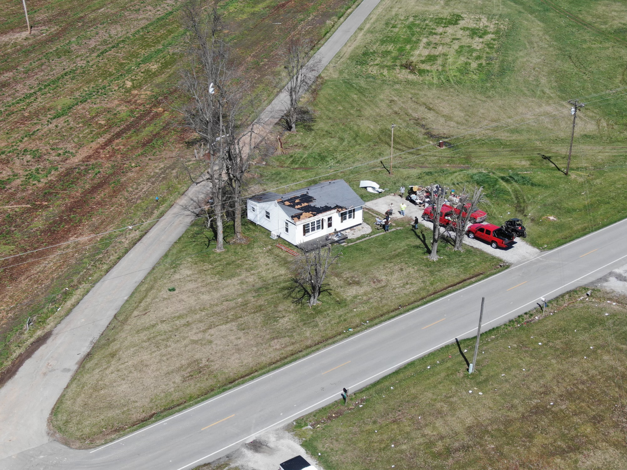
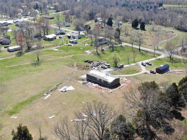
LaRue County, KY EF-1 Tornado Damage
 |
 |
 |
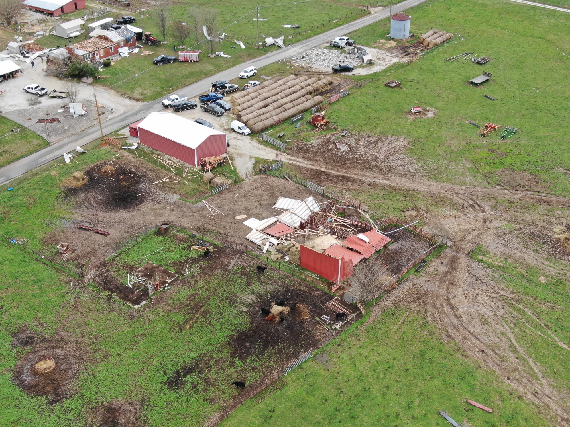 |
| Drone photo of property damage left by an EF-1 tornado in LaRue County, KY (NWS Storm Survey) |
Additional drone footage from LaRue County, KY (NWS Storm Survey) |
Additional drone footage from LaRue County, KY (NWS Storm Survey) |
Additional drone footage from LaRue County, KY (NWS Storm Survey) |
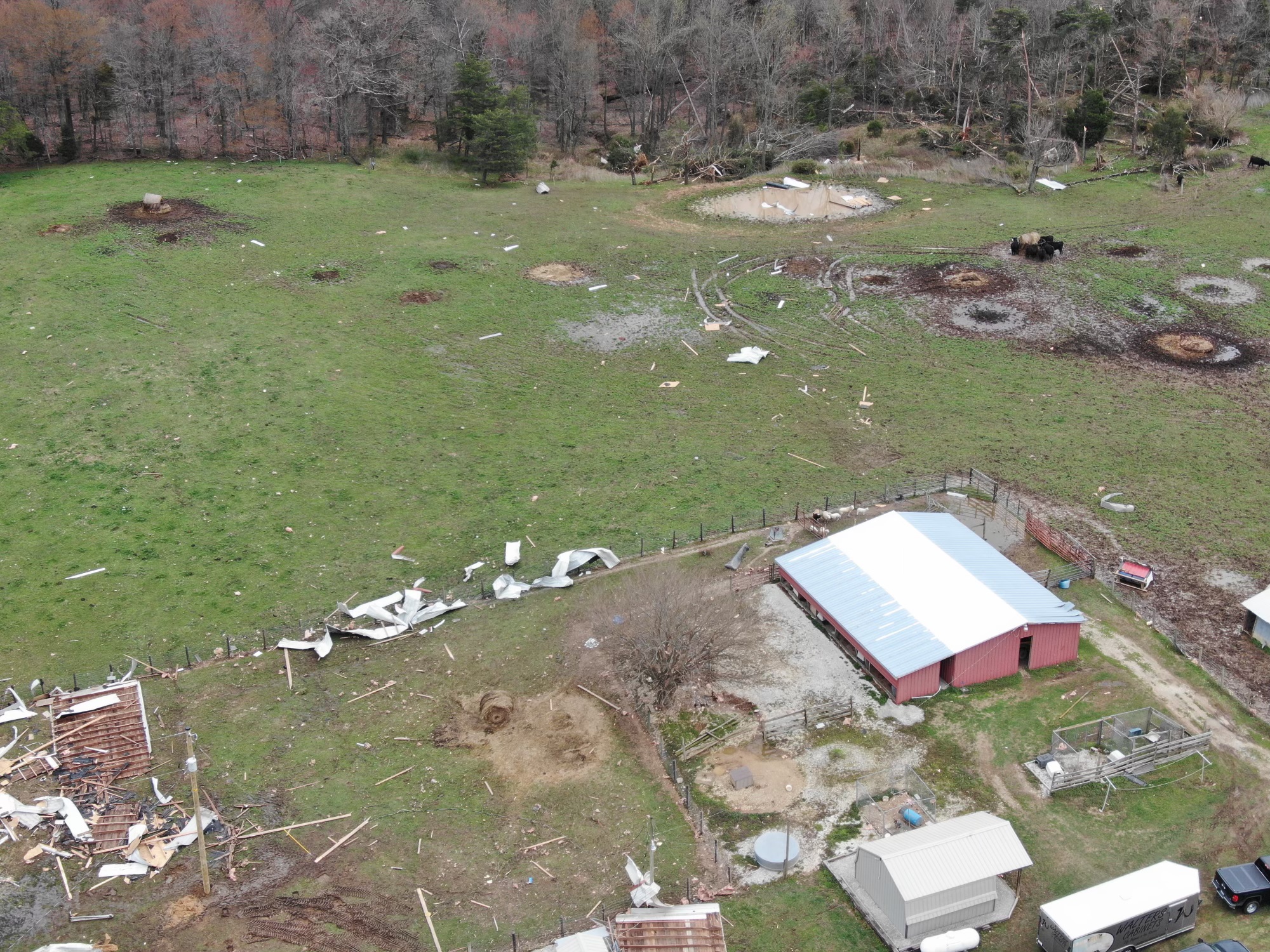
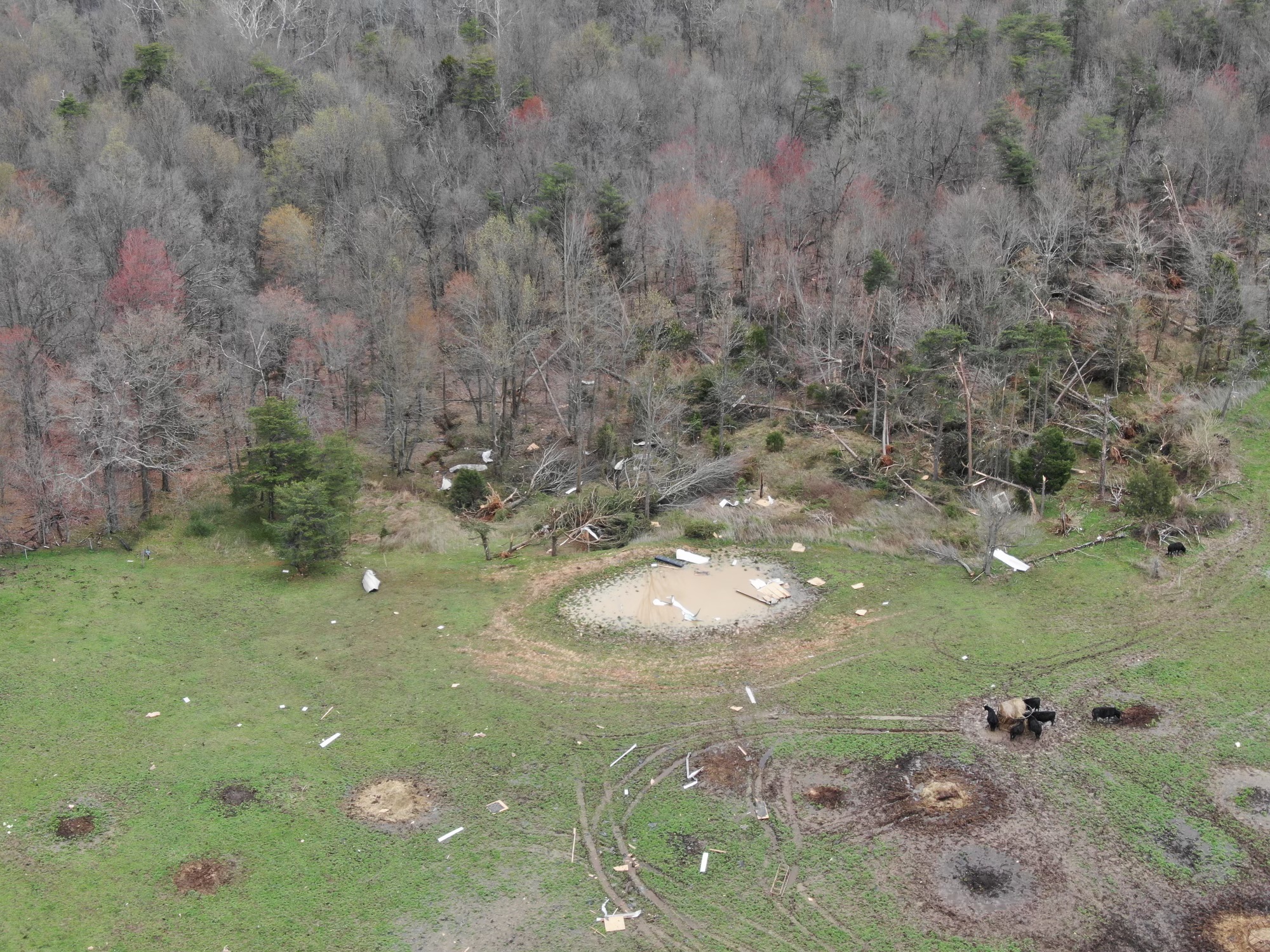
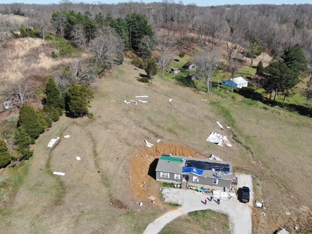
Grayson County, KY EF-0 Tornado Damage
 |
 |
 |
 |
| Drone photo of ground swirls created by EF-0 tornado in Grayson County, KY (NWS Storm Survey) |
Additional drone footage from Grayson County, KY (NWS Storm Survey) |
Additional drone footage from Grayson County, KY (NWS Storm Survey) |
Additional drone footage from Grayson County, KY (NWS Storm Survey) |
Ohio County, KY EF-0 Tornado Damage
 |
 |
 |
| Drone photo of property damage done by an EF-0 tornado in Ohio County, KY (NWS Storm Survey) |
Additional drone footage from Ohio County, KY (NWS Storm Survey) |
Additional drone footage from Ohio County, KY (NWS Storm Survey) |
Ground Swirls from EF-0 Tornado in Grayson County, KY
Radar
LaRue County, KY EF-1 Tornado
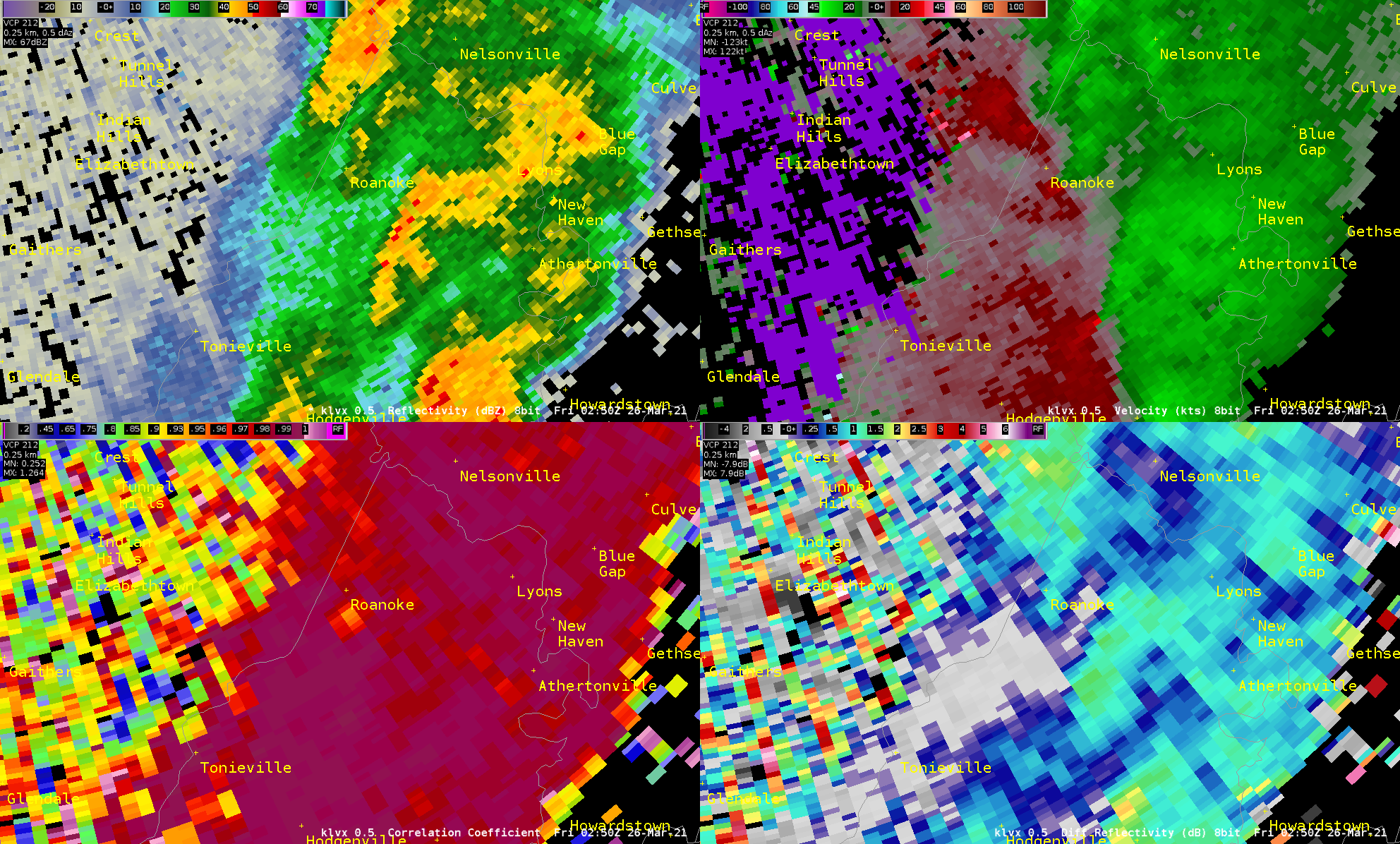 |
| 4-panel radar imagery showing clockwise from upper left: Reflectivity (Z), Velocity (V), Differential Reflectivity (ZDR), and Correlation Coefficient (CC). The most notable feature here is the circulation evident on V, which is coincident with a weak Tornadic Debris Signature (TDS) on CC. |
Grayson County, KY EF-0 Tornado
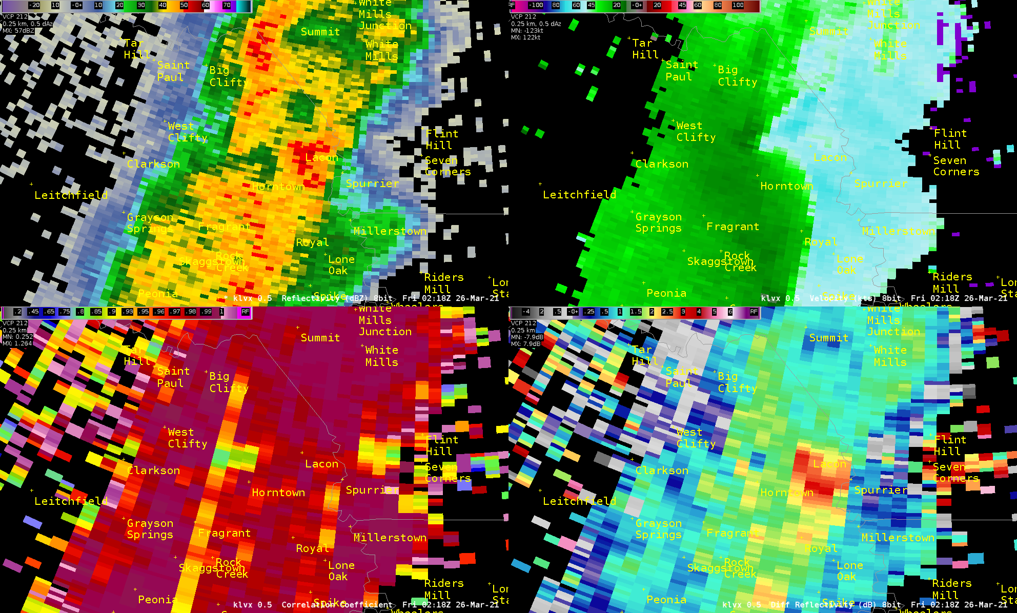 |
| 4-panel radar imagery showing clockwise from upper left: Reflectivity (Z), Velocity (V), Differential Reflectivity (ZDR), and Correlation Coefficient (CC). Again, the most notable feature is the circulation evident on V, which is coincident with a weak Tornadic Debris Signature (TDS) on CC. |
Ohio County, KY EF-0 Tornado
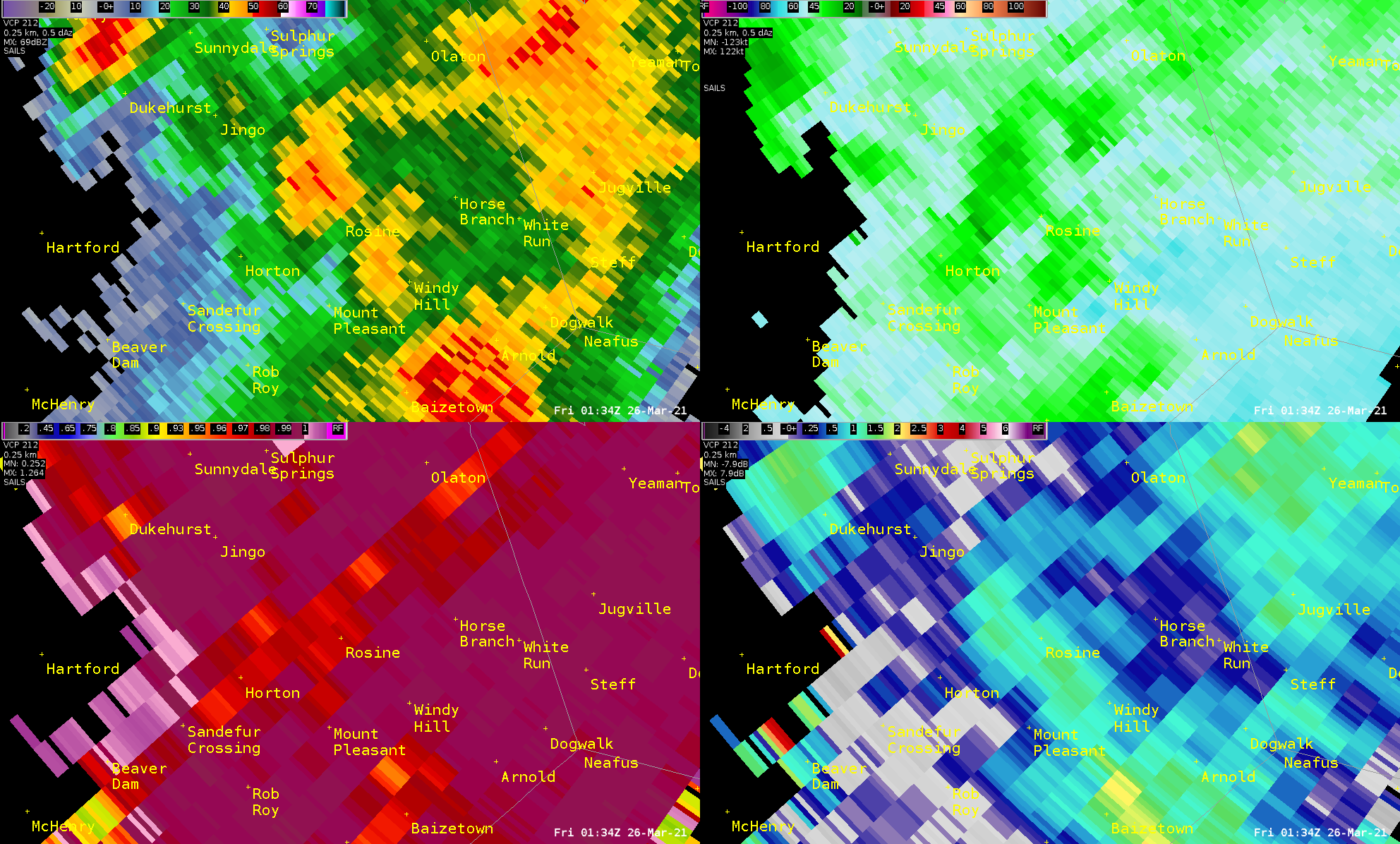 |
| 4-panel radar imagery showing clockwise from upper left: Reflectivity (Z), Velocity (V), Differential Reflectivity (ZDR), and Correlation Coefficient (CC). Tornadic features on this image are less evident, but subtle circulation can be seen on V that is coincident with a weak hook on Z. |
Radar Animation of Entire Event
Storm Reports
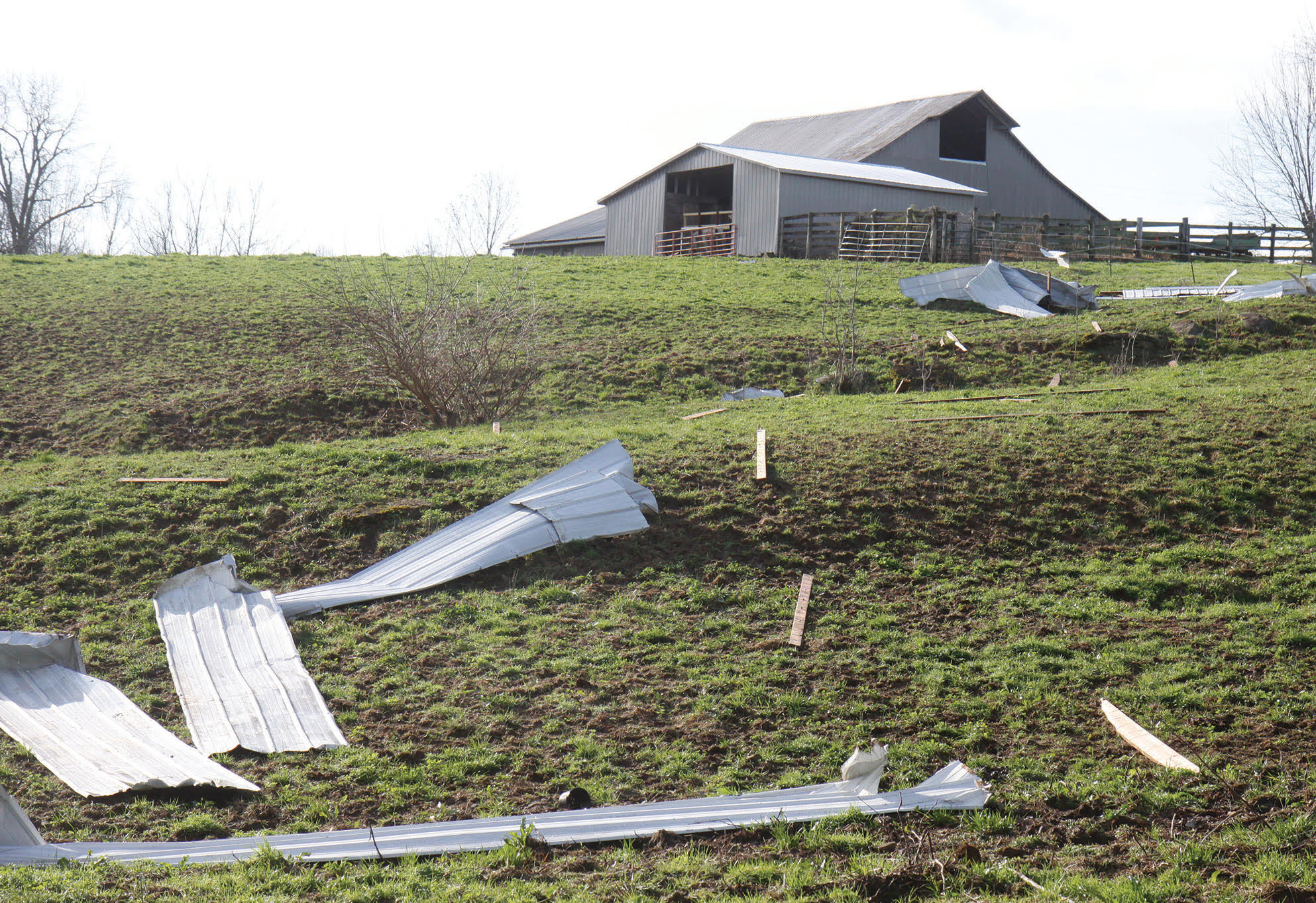
PRELIMINARY LOCAL STORM REPORT...SUMMARY
NATIONAL WEATHER SERVICE LOUISVILLE KY
426 AM EDT SAT MAR 27 2021

..TIME...   ...EVENT...      ...CITY LOCATION...     ...LAT.LON...
..DATE...   ....MAG....      ..COUNTY LOCATION..ST.. ...SOURCE....
            ..REMARKS..

0608 PM     TSTM WND DMG     2 ENE RAPIDS            36.68N 86.43W
03/25/2021                   SIMPSON            KY   EMERGENCY MNGR

            REPORT OF MULTIPLE TREES DOWN IN THE AREA OF
            LEO BINION RD. AND PLEASANT HILL RD.

0609 PM     TSTM WND DMG     2 NE MT. ARIEAL         36.77N 86.35W
03/25/2021                   ALLEN              KY   PUBLIC

            VIA PHOTO, WILLOW TREE UPROOTED AND CRUSHES
            SHED ALONG WITH BRADFORD PEAR UPROOTED ON
            PROPERTY.

0611 PM     TSTM WND DMG     1 E MT. ARIEAL          36.75N 86.36W
03/25/2021                   ALLEN              KY   BROADCAST MEDIA

            PHOTO SHOWS BROKEN CEDAR TRUNK ON THE WEST
            SIDE OF KY 585 WITH THE TOPS ON THE EAST
            SIDE OF THE ROAD, JUST NORTH OF THE KY1332
            INTERSECTION.

0613 PM     TSTM WND DMG     2 N HALFWAY             36.83N 86.29W
03/25/2021                   ALLEN              KY   PUBLIC

            REPORTS OF TREES DOWN AS WELL AS A POWER
            POLE. DAMAGE TO ROOF ON THE RESIDENCE PORCH
            AND MID-SECTION OF THE HOME. POWER METER
            FOUND OFF HOME IN THE YARD AND DAMAGED.

0613 PM     TSTM WND DMG     1 SE MT. ARIEAL         36.74N 86.37W
03/25/2021                   ALLEN              KY   BROADCAST MEDIA

            PHOTOS SHOW DAMAGE TO A METAL ROOF ON A BARN
            AND LIGHTLY CONSTRUCTED TUNNEL GREENHOUSES
            FLATTENED AND DESTROYED.

0614 PM     TSTM WND DMG     3 SE CLAYPOOL           36.87N 86.22W
03/25/2021                   ALLEN              KY   BROADCAST MEDIA

            REPORT WITH PHOTO OF A TREE DOWN ON A HOME
            IN NORTHWESTERN ALLEN COUNTY.

0629 PM     TSTM WND DMG     2 W PARK CITY           37.09N 86.09W
03/25/2021                   EDMONSON           KY   PUBLIC

            REPORTS OF CEDAR TREES DOWN ACROSS 31W
            BLOCKING THREE LANES AND REPORTS OF TWO
            BUILDINGS DAMAGED.

0636 PM     HAIL             3 E MAMMOTH CAVE        37.19N 86.04W
03/25/2021  E0.70 INCH       HART               KY   PUBLIC

            1 TO 2 MINUTES OF INTENSE DIME SIZE HAIL.

0642 PM     TSTM WND DMG     2 E KESSINGER           37.30N 85.94W
03/25/2021                   HART               KY   BROADCAST MEDIA

            ROOF LOSS ON A BARN NEAR MT. BEULAH. TIME
            BASED ON RADAR IMAGERY.

0718 PM     HAIL             4 NNE BOSTON            37.83N 85.63W
03/25/2021  M1.00 INCH       NELSON             KY   PUBLIC

            QUARTER SIZED HAIL FROM NWS EMPLOYEE FAMILY
            MEMBER ON HURRICANE HILLS LAKE.

0720 PM     HAIL             DEATSVILLE              37.90N 85.56W
03/25/2021  E1.00 INCH       NELSON             KY   PUBLIC

            PHOTO OF ESTIMATE 1 INCH HAIL OUT OF
            DEATSVILLE.

0723 PM     TSTM WND DMG     COXS CREEK              37.90N 85.47W
03/25/2021                   NELSON             KY   PUBLIC

            LARGE TREE BRANCH CAME DOWN AND DESTROYED A
            TRAMPOLINE. TIME BASED ON RADAR DATA.

0738 PM     HAIL             3 NW ELK CREEK          38.13N 85.40W
03/25/2021  E1.50 INCH       SPENCER            KY   PUBLIC

            GOLF BALL SIZED HAIL REPORTED ON BATTERY LN.

0745 PM     HAIL             1 ENE SIMPSONVILLE      38.22N 85.34W
03/25/2021  E1.00 INCH       SHELBY             KY   BROADCAST MEDIA

            PHOTO VIA SOCIAL MEDIA OF QUARTER SIZE HAIL
            NEAR SIMPSONVILLE.

0750 PM     HAIL             1 SSE SIMPSONVILLE      38.20N 85.35W
03/25/2021  E1.75 INCH       SHELBY             KY   PUBLIC

            GOLF BALL SIZED HAIL REPORTED AT 750 PM EDT
            AT CULVERS NEAR THE OUTLET SHOPPES OF THE
            BLUEGRASS ALONG I-64.

0932 PM     TORNADO          ROSINE                  37.45N 86.75W
03/25/2021                   OHIO               KY   NWS STORM SURVEY

            SHORT-LIVED EF-0 TORNADO WAS ON THE GROUND
            FOR 0.7 MILES WITH A MAXIMUM WIDTH OF 50
            YARDS AS IT TRAVELED EAST NORTHEAST. MINOR
            ROOF DAMAGE TO A DOLLAR GENERAL STORE ALONG
            WITH SNAPPING/UPROOTING OF A FEW TREES. MORE
            SUBSTANTIAL DAMAGE DONE ON 1544 IN ROSINE,
            WHERE SEVERAL HOMES RECEIVED SHINGLE DAMAGE
            ALONG WITH MORE SNAPPED/UPROOTED TREES. ALSO
            HAD SOME MOBILE HOME DAMAGE.

0943 PM     TSTM WND DMG     BEAVER DAM              37.41N 86.88W
03/25/2021                   OHIO               KY   COUNTY OFFICIAL

            ONE SNAPPED POWER POLE IN THE BEAVER DAM
            AREA.

1005 PM     TSTM WND DMG     1 NW LEITCHFIELD        37.49N 86.30W
03/25/2021                   GRAYSON            KY   FIRE DEPT/RESCUE

            SHINGLES REMOVED FROM ROOF, DAMAGE TO
            OUTBUILDING.

1015 PM     TSTM WND DMG     4 E CLARKSON            37.48N 86.15W
03/25/2021                   GRAYSON            KY   FIRE DEPT/RESCUE

            ROOF OFF HOUSE AND WINDOWS BLOWN OUT.
            ATTACHED GARAGE DAMAGED. OUTBUILDING
            DAMAGED. OLD BARN DAMAGED. POWER LINES AND
            POLES DOWN.

1016 PM     TSTM WND DMG     4 S BIG CLIFTY          37.50N 86.15W
03/25/2021                   GRAYSON            KY   FIRE DEPT/RESCUE

            SEVERAL LARGE TREES DOWN.

1016 PM     TORNADO          4 ESE CLARKSON          37.48N 86.16W
03/25/2021                   GRAYSON            KY   NWS STORM SURVEY

            1 MILE LONG EF-0 TORNADO WITH MAXIMUM WIDTH
            OF 40 YARDS. BRIEF TORNADO THAT CAUSED
            DAMAGE IN THE 3900 BLOCK OF MILLERSTOWN
            ROAD. ALSO OF INTEREST WAS A VERY NOTICEABLE
            GROUND SWIRL...FROM DRONE FOOTAGE...IN OPEN
            FARMLAND.

1018 PM     TSTM WND DMG     5 NW MILLERSTOWN        37.48N 86.13W
03/25/2021                   GRAYSON            KY   UTILITY COMPANY

            NUMEROUS POWER OUTAGES IN THE MILLERSTOWN
            AREA OF GRAYSON COUNTY.

1030 PM     TSTM WND DMG     2 NW LEITCHFIELD        37.50N 86.31W
03/25/2021                   GRAYSON            KY   TRAINED SPOTTER

            LARGE TREE ON HOUSE ABOUT ALONG HIGHWAY 737
            WEST OF LEITCHFIELD.

1035 PM     TSTM WND DMG     3 ENE GLENDALE          37.61N 85.86W
03/25/2021                   HARDIN             KY   BROADCAST MEDIA

            BROADCAST MEDIA REPORTED DAMAGE TO A HOUSE
            (ROOF BLOW AWAY) AND HEAVY DAMAGE TO A
            MOBILE HOME BOTH ALONG FIRST UNION CHURCH
            RD. TIME ESTIMATED FROM RADAR.

1044 PM     TORNADO          3 NE TONNIEVILLE        37.63N 85.76W
03/25/2021                   LARUE              KY   NWS STORM SURVEY

            4.5 MILE LENGTH EF-1 TORNADO. MAXIMUM WIDTH
            75 YARDS. DRONE FOOTAGE SHOWED DISTINCT
            SWIRLS ON FARMLAND. SEVERAL STRUCTURES WERE
            DAMAGED ALONG THE PATH AS WELL AS NUMEROUS
            UPROOTED/SNAPPED TREES. MOST SIGNIFICANT
            DAMAGE IN THE 3000 BLOCK OF SLACK ROAD WHERE
            TWO BARNS WERE DESTROYED AND SIGNIFICANT
            ROOF DAMAGE OCCURRED AT A WELL-BUILT ONE
            STORY RESIDENCE.

1045 PM     TSTM WND DMG     3 NE TONNIEVILLE        37.63N 85.76W
03/25/2021                   LARUE              KY   911 CALL CENTER

            SEVERAL DAMAGE REPORTS FROM CARTER BROTHERS
            ROAD EAST TO SHEPHERDSVILLE ROAD AND THEN
            CONTINUING TO DAN DUN ROAD, SPENCER SCHOOL
            ROAD, AND INTERSECTION OF CISSAL HILL ROAD
            AND ROANOKE ROAD. AT LEAST 2 BUILDINGS WITH
            LOTS OF DAMAGE, ONE COLLAPSED. SEVERAL TREES
            DOWN AND A FEW POLES DOWN. A FEW OTHER
            STRUCTURES DAMAGED. TIME OF INITIAL DAMAGE
            ESTIMATED FROM RADAR.

1050 PM     TSTM WND DMG     4 WSW LYONS             37.67N 85.69W
03/25/2021                   LARUE              KY   911 CALL CENTER

            APPROXIMATE END POINT OF DAMAGE MENTIONED IN
            PREVIOUS REPORT. TIME ESTIMATED FROM RADAR.

1135 PM     TSTM WND DMG     2 NNW CANAAN            38.90N 85.31W
03/25/2021                   JEFFERSON          IN   911 CALL CENTER

            8 INCH DIAMETER TREE DOWN ON THE ROAD NEAR
            THE INTERSECTION OF JEFFERSON AND LEMON
            ROADS. ALSO CLEARING A TREE ON SR 62 NEAR
            CHINAVILLE ROAD. TIME ESTIMATED BASED ON
            RADAR.

1135 PM     NON-TSTM WND GST 2 N JOHNSBURG           38.25N 86.95W
03/25/2021  M51 MPH          DUBOIS             IN   ASOS

            REPORTED AT HUNTINGBURG AIRPORT.

1145 PM     TSTM WND DMG     GEORGETOWN              38.21N 84.55W
03/25/2021                   SCOTT              KY   AMATEUR RADIO

            CORRECTS PREVIOUS TSTM WND DMG REPORT FROM
            GEORGETOWN. LARGE TREE DOWN ACROSS
            WARRENDALE AVE. NO DAMAGE TO STRUCTURES OR
            POWERLINES REPORTED.

1207 AM     NON-TSTM WND GST 6 W LEXINGTON           38.04N 84.61W
03/26/2021  M48 MPH          FAYETTE            KY   ASOS

            REPORTED AT KLEX.
.
Environment
Synoptic Overview
 |
 |
 |
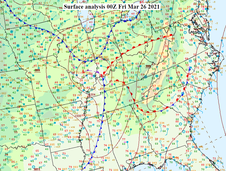 |
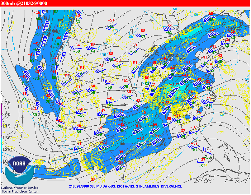
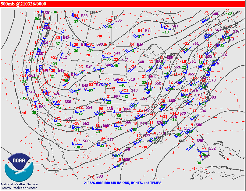
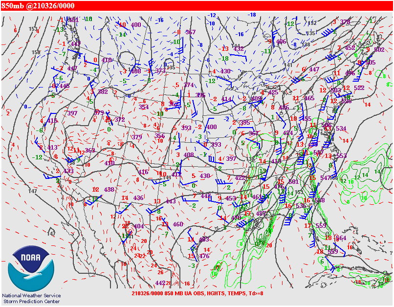
| Figure 1: 300mb upper air chart 00Z March 26, 2021 | Figure 2: 500mb upper air chart 00Z March 26, 2021 | Figure 3: 850mb upper air chart 00Z March 26, 2021 | Figure 4: WPC's 00Z Surface Analysis March 26, 2021 |
Near-storm Environment
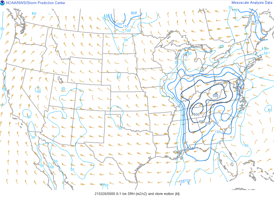
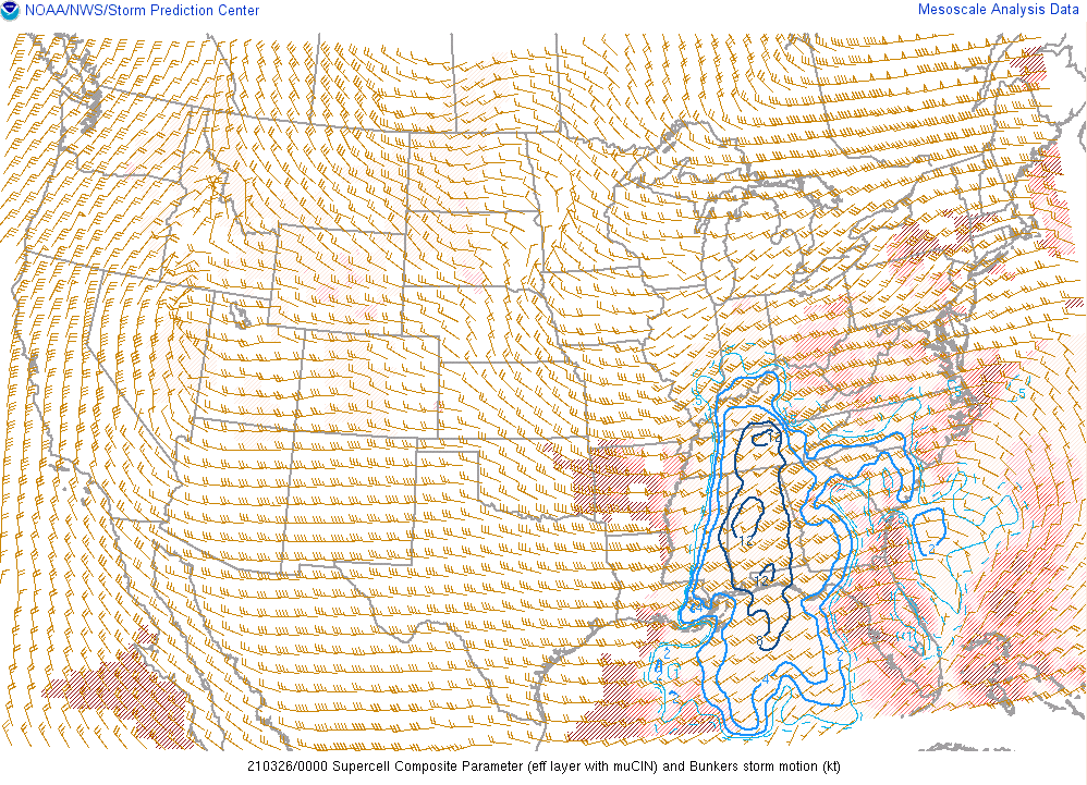
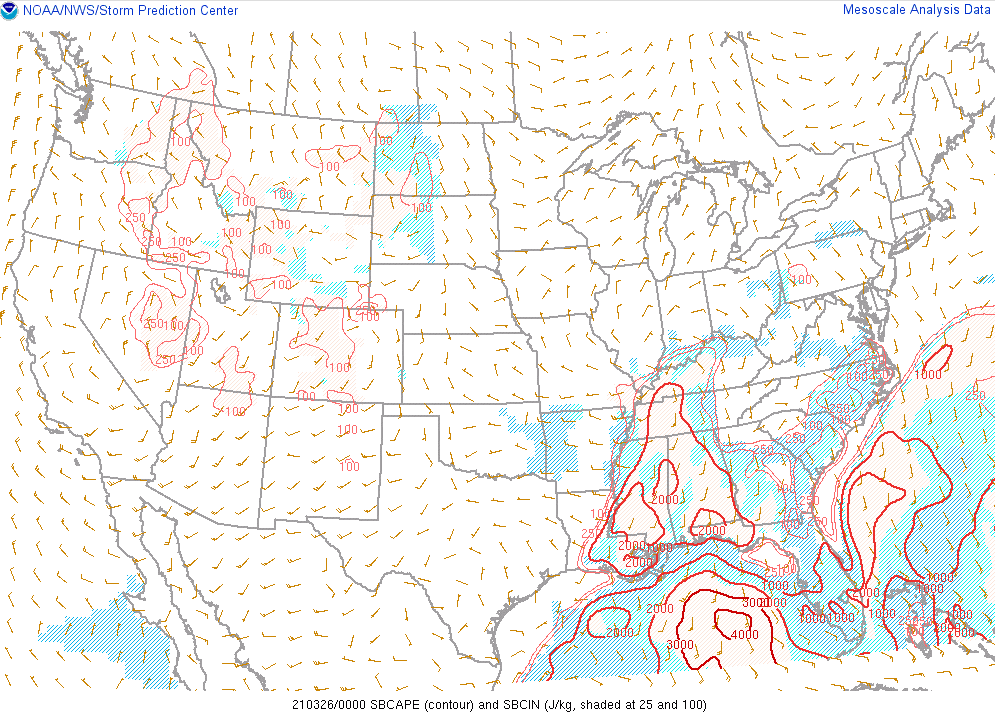 |
 |
 |
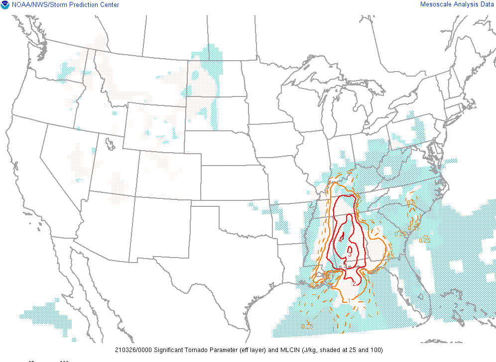 |
| Figure 5: Surface Based CAPE 00Z March 26, 2021 | Figure 6: 0-1km Storm Relative Helicity (SRH) 00Z March 26, 2021 | Figure 7: Supercell Composite Parameter (SCP) 00Z March 26, 2021 | Figure 8: Significant Tornado Parameter 00Z March 26, 2021 |
Additional environmental data.
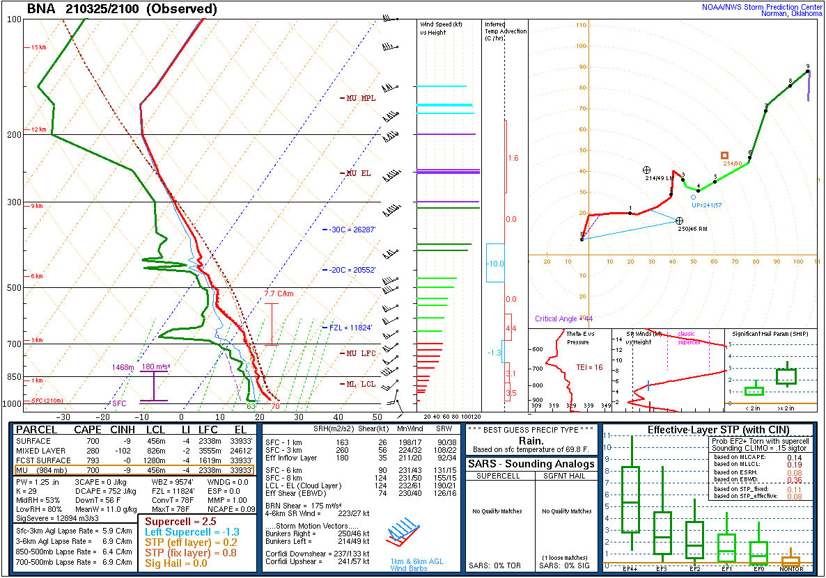 |
| Figure 9: Upper Air Sounding from Nashville, TN (BNA) 21Z March 25, 2021 |
 |
Media use of NWS Web News Stories is encouraged! Please acknowledge the NWS as the source of any news information accessed from this site. |
|


 Weather Story
 Weather Map
 Local Radar