Louisville, KY
Weather Forecast Office
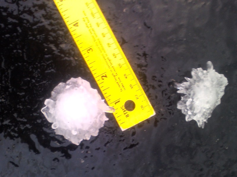
A NWS storm survey team surveyed Barren, Metcalfe, Green, Adair, and Russell counties. Several pine trees were down within the hail path, but likely due to straight-line winds. Several people reported seeing a funnel cloud, including Russell County Emergency Management personnel, who chased the funnel cloud to Highway 80 toward Pulaski County. No tornado damage was found, but that area did suffer extensive large hail damage. The most significant hail damage was found in and near Columbia in Adair County. Along one stretch of roadway from the Metcalfe/Adair county line to the city of Columbia, not one vehicle was found that did not have its windshield damaged. In the city of Columbia, one house had hail break through the roof and a Wal-Mart store had 160 skylights damaged.
Hail in Columbia. Photo courtesy Kristy Keene
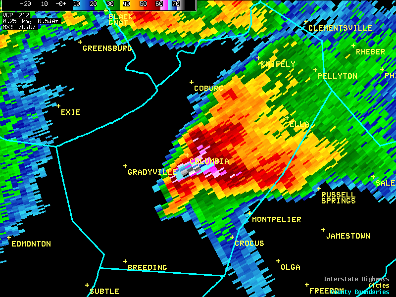
Below is a radar image of the storm as it was hitting the south side of Columbia. The very bright colors indicate large hail. The blue colors shooting off to the southeast represent a "hail spike" or "scatter spike" which is sometimes seen on radar displays when the radar beam strikes very large, wet hail. In an area of large hail, radiation from the radar can bounce from hailstone to hailstone before being reflected back to the radar. The time delay between the backscattered radiation from the storm and the bounced and scattered radiation from the large hail causes the reflectivity from the hail to appear to come from a farther range than the actual storm.
Current Hazards
Hazardous Weather Outlook
Storm Prediction Center
Submit a Storm Report
Advisory/Warning Criteria
Radar
Fort Knox
Evansville
Fort Campbell
Nashville
Jackson
Wilmington
Latest Forecasts
El Nino and La Nina
Climate Prediction
Central U.S. Weather Stories
1-Stop Winter Forecast
Aviation
IDSS Forecast Points
Air Quality
Fire Weather
Recreation Forecasts
1-Stop Drought
Event Ready
1-Stop Severe Forecast
Past Weather
Climate Graphs
1-Stop Climate
CoCoRaHS
Local Climate Pages
Tornado History
Past Derby/Oaks/Thunder Weather
Football Weather
Local Information
About the NWS
Forecast Discussion
Items of Interest
Spotter Training
Regional Weather Map
Decision Support Page
Text Products
Science and Technology
Outreach
LMK Warning Area
About Our Office
Station History
Hazardous Weather Outlook
Local Climate Page
Tornado Machine Plans
Weather Enterprise Resources
US Dept of Commerce
National Oceanic and Atmospheric Administration
National Weather Service
Louisville, KY
6201 Theiler Lane
Louisville, KY 40229-1476
502-969-8842
Comments? Questions? Please Contact Us.


 Weather Story
 Weather Map
 Local Radar