
A Nor'easter will bring significant coastal impacts to the Mid-Atlantic and New England into Monday. Moderate to major coastal flooding, heavy rain, strong winds and high surf expected. Hurricane Nolo is expected to remain south of the Big Island of Hawaii. However, strong winds, damaging waves, and heavy rainfall may bring significant, life-threatening flooding and mudslides through the weekend. Read More >
Louisville, KY
Weather Forecast Office
Logan County Straight Line Wind Damage
Supercell #1:
Begin Time: 3:30 PM CST
End Time: 3:31 PM CST
Begin Point: Deer Lick Road in NW Logan County
End Point: Deer Lick Road in NW Logan County
Wind Speed: 60 MPH
Injuries: 0
Fatalities: 0
The National Weather Service in conjunction with the Logan County Emergency Management conducted a storm survey in Logan County, Kentucky.
It was determined straight-line winds downed a few trees on Deer Lick Road in northwestern Logan County. The National Weather Service in Louisville would like to thank the NWS office in Nashville for their assistance with the storm damage survey.
Supercell #2:
Begin Time: 4:07 PM CST
End Time: 4:08 PM CST
Begin Point: 5 miles SW of Russellville
End Point: 5 miles SW of Russellville
Wind Speed: 75 MPH
Injuries: 0
Fatalities: 0
The National Weather Service in conjunction with Logan County, KY Emergency Management concluded in their storm survey that straight-line winds destroyed a barn one mile south-southeast of the intersection of US 79 and SR 1041 along SR 1041 just southeast of Cave Springs. There was also minor roof/siding damage to a home in this area, and there were several trees down.
The National Weather Service in Louisville would like to thank the NWS office in Nashville for their assistance with the storm damage survey.
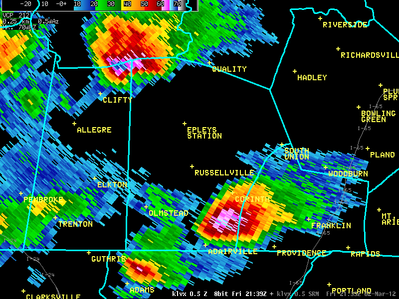
Here's a radar image of storms crossing opposite corners of Logan County. The northwestern storm is "Supercell #1" above. The NWS didn't receive any reports from the southeastern storm, but it likely did produce hail as well.
Current Hazards
Hazardous Weather Outlook
Storm Prediction Center
Submit a Storm Report
Advisory/Warning Criteria
Radar
Fort Knox
Evansville
Fort Campbell
Nashville
Jackson
Wilmington
Latest Forecasts
El Nino and La Nina
Climate Prediction
Central U.S. Weather Stories
1-Stop Winter Forecast
Aviation
IDSS Forecast Points
Air Quality
Fire Weather
Recreation Forecasts
1-Stop Drought
Event Ready
1-Stop Severe Forecast
Past Weather
Climate Graphs
1-Stop Climate
CoCoRaHS
Local Climate Pages
Tornado History
Past Derby/Oaks/Thunder Weather
Football Weather
Local Information
About the NWS
Forecast Discussion
Items of Interest
Spotter Training
Regional Weather Map
Decision Support Page
Text Products
Science and Technology
Outreach
LMK Warning Area
About Our Office
Station History
Hazardous Weather Outlook
Local Climate Page
Tornado Machine Plans
Weather Enterprise Resources

US Dept of Commerce
National Oceanic and Atmospheric Administration
National Weather Service
Louisville, KY
6201 Theiler Lane
Louisville, KY 40229-1476
502-969-8842
Comments? Questions? Please Contact Us.


 Weather Story
 Weather Map
 Local Radar
 Follow us on X
 Follow us on Facebook
 Follow us on YouTube
 LMK RSS Feed