After an April with no severe weather, May was also very quiet. The only significant severe weather of the month took place on the 3rd when the year's fifth tornado touched down. Just after eight o'clock in the morning a small tornado, only about 180 feet wide, was on the ground for half a mile in Tompkinsville. Most of the damage was to trees, power lines, and rooftops. Also on this day hail around the size of quarters was reported in Warren County and trees were blown down in Burkesville.
The only other storm damage of the month was when trees were blown down near the Makers Mark Distillery in Marion County on the 4th. Also on that date Bowling Green was drenched with 3.11" of rain...the 8th wettest May day on record for the city.
Overall, temperatures were not oppressive. Cool weather prevailed from the 5th to the 16th, with highs in the 60s and lows mostly in the 40s, but some spots did dip into the 30s several times during that stretch. On the 6th the mercury fell to 36 degrees at Lexington, just two degrees away from the record.
The one warm spell took place from the 19th to the 27th, peaking from the 23rd to the 25th when Louisville hit exactly 90 each day. However, dew points were low so it wasn't very humid, and morning lows were in the 60s.
The month ended on a chilly note with clouds and drizzle leading to record cool high temperatures in the 50s on the 29th.
| Average Temperature | Departure from Normal | Precipitation | Departure from Normal | |
| Bowling Green | 64.6° | -3.4° | 4.80" | -0.23" |
| Frankfort | 62.8° | -2.7° | 2.88" | -2.22" |
| Lexington | 61.1° | -4.3° | 4.78" | -0.66" |
| Louisville Ali | 66.0° | -2.3° | 2.95" | -2.23" |
| Louisville Bowman | 64.2° | -3.0° | 2.61" | -2.55" |
Records
4th: Rainfall of 3.11" at Bowling Green, 8th wettest May day on record at Bowling Green
28th: Rainfall of 1.59" at Lexington
29th: Cool high of 57° at Bowling Green, cool high of 52° at Lexington, cool high of 57° at Louisville
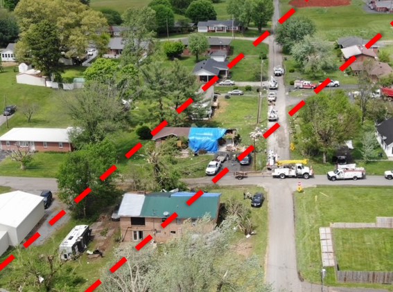
Tornado damage at the corner of Fifth and Irdu in Tompkinsville on the 3rd. Image from NWS Louisville drone survey.


 Weather Story
 Weather Map
 Local Radar