Louisville, KY
Weather Forecast Office
 |
|
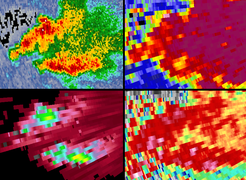
Conventional Doppler radar sends out a horizontal energy pulse providing a one dimensional view of precipitation. Dual pol radar sends both horizontal and vertical pulses, providing a two dimensional view. Thus, it provides much better information about the size, shape, and estimated amount of precipitation, distinguishing between rain, snow, and hail. Basic dual pol products include correlation coefficient (CC), differential reflectivity (ZDR), and specific differential phase (KDP). More information is available on our Dual Pol webpage. Above, two clusters of thunderstorms had high base reflectivity values between 50 and 60 dBZ (upper left). Meanwhile, CC data (upper right) showed high values above 0.96 (dark red/purple) in the same area as the high reflectivity values. High CC indicates similarly-shaped precipitation vs. a mix of types (i.e., hail-rain mix). ZDR (lower right) depicted values of 3.0-5.0 in the same location, suggesting large hamburger bun-shaped rain drops. KDP (lower left), often used to assess heavy rain using dual pol data, showed values of 2.0-5.0 suggesting a large concentration of rain and large drops. The combination of CC, ZDR, and KDP all supported the occurrence of very heavy rainfall with large drops in the storms, and little or no hail. Reflectivity alone cannot be used to specifically identify the exact nature of precipitation type and size in a storm. |
Current Hazards
Hazardous Weather Outlook
Storm Prediction Center
Submit a Storm Report
Advisory/Warning Criteria
Radar
Fort Knox
Evansville
Fort Campbell
Nashville
Jackson
Wilmington
Latest Forecasts
El Nino and La Nina
Climate Prediction
Central U.S. Weather Stories
1-Stop Winter Forecast
Aviation
IDSS Forecast Points
Air Quality
Fire Weather
Recreation Forecasts
1-Stop Drought
Event Ready
1-Stop Severe Forecast
Past Weather
Climate Graphs
1-Stop Climate
CoCoRaHS
Local Climate Pages
Tornado History
Past Derby/Oaks/Thunder Weather
Football Weather
Local Information
About the NWS
Forecast Discussion
Items of Interest
Spotter Training
Regional Weather Map
Decision Support Page
Text Products
Science and Technology
Outreach
LMK Warning Area
About Our Office
Station History
Hazardous Weather Outlook
Local Climate Page
Tornado Machine Plans
Weather Enterprise Resources
US Dept of Commerce
National Oceanic and Atmospheric Administration
National Weather Service
Louisville, KY
6201 Theiler Lane
Louisville, KY 40229-1476
502-969-8842
Comments? Questions? Please Contact Us.


 Weather Story
 Weather Map
 Local Radar