Louisville, KY
Weather Forecast Office
 |
|
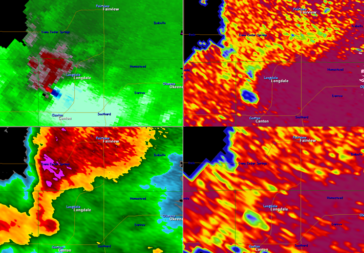
Conventional Doppler radar sends out a horizontal energy pulse providing a one dimensional view of precipitation. Dual pol radar sends both horizontal and vertical pulses, providing a two dimensional view. Thus, it provides much better information about the size, shape, and estimated amount of precipitation, distinguishing between rain, snow, and hail. Basic dual pol products include correlation coefficient (CC), differential reflectivity (ZDR), and specific differential phase (KDP). More information is available on our Dual Pol webpage. Above, base reflectivity (lower left) showed a classic supercell with a hook echo on its southern side. Corresponding storm-relative velocity data (upper left) showed a strong low-level mesocyclone (dark blue-red couplet) that was associated with a tornado at this time. Dual pol CC data (right 2 panels at different elevation angles) showed a definitive area of blue, or very low values of around 0.7 in the location of the mesocyclone and tornado. The low CC values indicates a concentrated cluster of particles of different sizes, thus producing entities that are not correlated in size and shape. This is dual pol's depiction of a "debris ball" at the location of the tornado, i.e., various debris caught within and rotating around the tornado, and lifted up into the parent thunderstorm. This CC signature would be less evident for weaker tornadoes and for storms distant from the radar. Reflectivity and velocity structure and trends are the primary data sources needed to determine tornado potential and evolution. |
Current Hazards
Hazardous Weather Outlook
Storm Prediction Center
Submit a Storm Report
Advisory/Warning Criteria
Radar
Fort Knox
Evansville
Fort Campbell
Nashville
Jackson
Wilmington
Latest Forecasts
El Nino and La Nina
Climate Prediction
Central U.S. Weather Stories
1-Stop Winter Forecast
Aviation
IDSS Forecast Points
Air Quality
Fire Weather
Recreation Forecasts
1-Stop Drought
Event Ready
1-Stop Severe Forecast
Past Weather
Climate Graphs
1-Stop Climate
CoCoRaHS
Local Climate Pages
Tornado History
Past Derby/Oaks/Thunder Weather
Football Weather
Local Information
About the NWS
Forecast Discussion
Items of Interest
Spotter Training
Regional Weather Map
Decision Support Page
Text Products
Science and Technology
Outreach
LMK Warning Area
About Our Office
Station History
Hazardous Weather Outlook
Local Climate Page
Tornado Machine Plans
Weather Enterprise Resources
US Dept of Commerce
National Oceanic and Atmospheric Administration
National Weather Service
Louisville, KY
6201 Theiler Lane
Louisville, KY 40229-1476
502-969-8842
Comments? Questions? Please Contact Us.


 Weather Story
 Weather Map
 Local Radar