Louisville, KY
Weather Forecast Office
 |
|
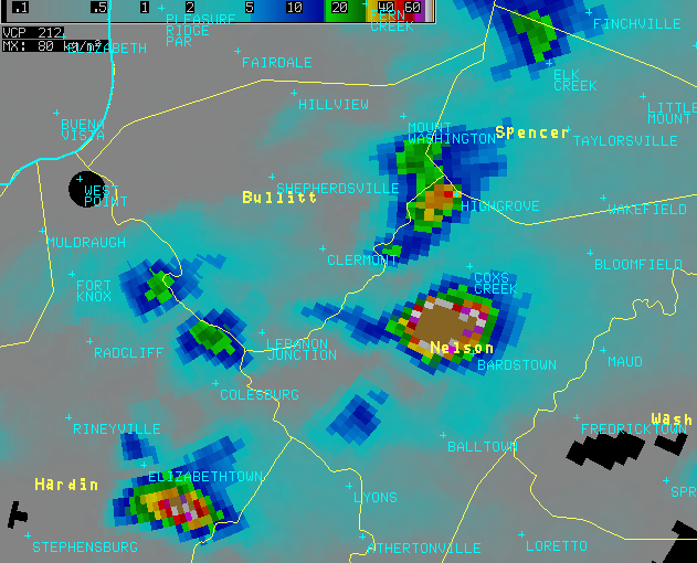
This is an example of the Digital Vertically Integrated Liquid (DVIL) derived product. DVIL is a vertical integration of reflectivity values within the full depth of a thunderstorm, with values converted to equivalent liquid water. DVIL is useful to identify storms containing hail and a large liquid water content (i.e., deep, tall storms). It helps differentiate the relative strength and depth of storms. Limitations exist, but it gives NWS forecasters a quick assessment of storms in an area. Above, DVIL is shown for several thunderstorms in north-central Kentucky in April 2011. The storm with the light brown color in Nelson County was severe, and had the highest DVIL values compared to other storms nearby. The storm southeast of Elizabethtown in Hardin County also was strong. Other cells had lower DVIL values and were weaker at this time. DVIL trends over time are very important and indicate growing or decaying storms. In fact, a storm with lowering DVIL values could be a collapsing cell about to produce a microburst before weakening. Intensifying storms (strong updrafts) would show increasing DVIL values. |
Current Hazards
Hazardous Weather Outlook
Storm Prediction Center
Submit a Storm Report
Advisory/Warning Criteria
Radar
Fort Knox
Evansville
Fort Campbell
Nashville
Jackson
Wilmington
Latest Forecasts
El Nino and La Nina
Climate Prediction
Central U.S. Weather Stories
1-Stop Winter Forecast
Aviation
IDSS Forecast Points
Air Quality
Fire Weather
Recreation Forecasts
1-Stop Drought
Event Ready
1-Stop Severe Forecast
Past Weather
Climate Graphs
1-Stop Climate
CoCoRaHS
Local Climate Pages
Tornado History
Past Derby/Oaks/Thunder Weather
Football Weather
Local Information
About the NWS
Forecast Discussion
Items of Interest
Spotter Training
Regional Weather Map
Decision Support Page
Text Products
Science and Technology
Outreach
LMK Warning Area
About Our Office
Station History
Hazardous Weather Outlook
Local Climate Page
Tornado Machine Plans
Weather Enterprise Resources
US Dept of Commerce
National Oceanic and Atmospheric Administration
National Weather Service
Louisville, KY
6201 Theiler Lane
Louisville, KY 40229-1476
502-969-8842
Comments? Questions? Please Contact Us.


 Weather Story
 Weather Map
 Local Radar