
Heavy rain and widely scattered severe storms are expected over portions of the central and southern Plains into the Ohio Valley. Unseasonable warmth will continue for a few more days across the Midwest, Southeast, and Mid-Atlantic where several daily record highs could fall. Read More >
Louisville, KY
Weather Forecast Office
 |
|
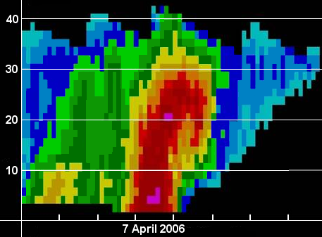
Vertical cross-sections of reflectivity (and velocity) data can be constructed from NWS Doppler radar. Forecasters "cut" a cross-sectional line through a precipitation entity or thunderstorm of interest. Software creates the chosen cross-section based on all radar elevation scans through the entity, which is then displayed for forecaster assessment. Cross-sections are extremely important in assessing the vertical structure of thunderstorms and severe weather potential. In the image of a supercell thunderstorm, a deep layer of heavy precipitation and possibly hail (red and pink colors) exists up to 30,000 ft with an echo top just over 40,000 ft. In addition, a bounded weak echo region (BWER) is present aloft between the main deep core of red color (downdraft location) and the "overhanging" red area to the right of the core, where an area of lower reflectivity values exist. A BWER indicates the location of the rotating updraft (mesocyclone) in a severe supercell. Since the updraft is displaced from the downdraft (and also due to dynamical processes in the storm), a supercell can maintain its intensity potentially for several hours. Blue colors in the upper right of the image represent light precipitation and ice crystals in the anvil of the storm downwind from the storm's core. |
Current Hazards
Hazardous Weather Outlook
Storm Prediction Center
Submit a Storm Report
Advisory/Warning Criteria
Radar
Fort Knox
Evansville
Fort Campbell
Nashville
Jackson
Wilmington
Latest Forecasts
El Nino and La Nina
Climate Prediction
Central U.S. Weather Stories
1-Stop Winter Forecast
Aviation
IDSS Forecast Points
Air Quality
Fire Weather
Recreation Forecasts
1-Stop Drought
Event Ready
1-Stop Severe Forecast
Past Weather
Climate Graphs
1-Stop Climate
CoCoRaHS
Local Climate Pages
Tornado History
Past Derby/Oaks/Thunder Weather
Football Weather
Local Information
About the NWS
Forecast Discussion
Items of Interest
Spotter Training
Regional Weather Map
Decision Support Page
Text Products
Science and Technology
Outreach
LMK Warning Area
About Our Office
Station History
Hazardous Weather Outlook
Local Climate Page
Tornado Machine Plans
Weather Enterprise Resources

US Dept of Commerce
National Oceanic and Atmospheric Administration
National Weather Service
Louisville, KY
6201 Theiler Lane
Louisville, KY 40229-1476
502-969-8842
Comments? Questions? Please Contact Us.


 Weather Story
 Weather Map
 Local Radar
 Follow us on X
 Follow us on Facebook
 Follow us on YouTube
 LMK RSS Feed