Louisville, KY
Weather Forecast Office
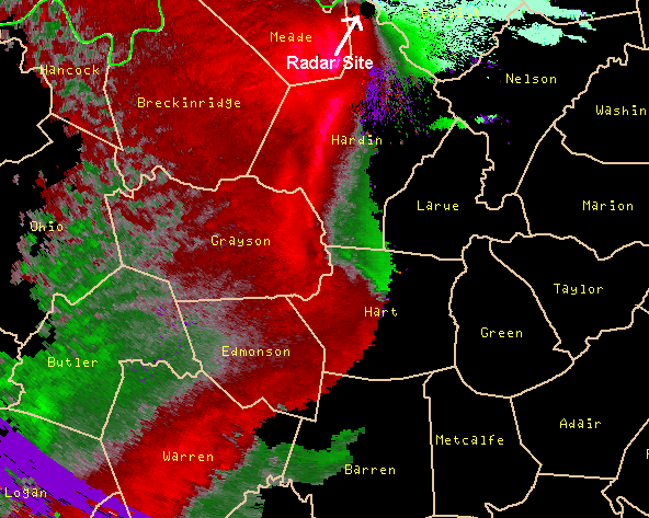 |
NWS Doppler radar senses atmospheric motion based on cloud and precipitation movement toward (green) and away from (red) the radar (radial velocity). Two types of velocity exist: base (ground-relative) velocity, and storm-relative velocity map (SRM). SRM equals storm motion minus base velocity, and shows winds "felt" by entities (e.g., thunderstorms) as they move through their environment. For more information, consult "Overview of the WSR-88D Radar System." SRM detects rotation in severe storms, and patterns of convergence and divergence. The image here shows KLVX 0.5 degree SRM on April 24, 2010 of a bow echo over central Kentucky. The radar is at Ft. Knox (top of image). The interface between green inbound and red outbound colors in Hardin and Hart counties represents the leading edge (gust front) of the convective system, and where severe weather can occur. In this event, wind damage occurred over parts of Hart County where broad counterclockwise (cyclonic) motion was indicated. |
Current Hazards
Hazardous Weather Outlook
Storm Prediction Center
Submit a Storm Report
Advisory/Warning Criteria
Radar
Fort Knox
Evansville
Fort Campbell
Nashville
Jackson
Wilmington
Latest Forecasts
El Nino and La Nina
Climate Prediction
Central U.S. Weather Stories
1-Stop Winter Forecast
Aviation
IDSS Forecast Points
Air Quality
Fire Weather
Recreation Forecasts
1-Stop Drought
Event Ready
1-Stop Severe Forecast
Past Weather
Climate Graphs
1-Stop Climate
CoCoRaHS
Local Climate Pages
Tornado History
Past Derby/Oaks/Thunder Weather
Football Weather
Local Information
About the NWS
Forecast Discussion
Items of Interest
Spotter Training
Regional Weather Map
Decision Support Page
Text Products
Science and Technology
Outreach
LMK Warning Area
About Our Office
Station History
Hazardous Weather Outlook
Local Climate Page
Tornado Machine Plans
Weather Enterprise Resources
US Dept of Commerce
National Oceanic and Atmospheric Administration
National Weather Service
Louisville, KY
6201 Theiler Lane
Louisville, KY 40229-1476
502-969-8842
Comments? Questions? Please Contact Us.


 Weather Story
 Weather Map
 Local Radar