Overview
|
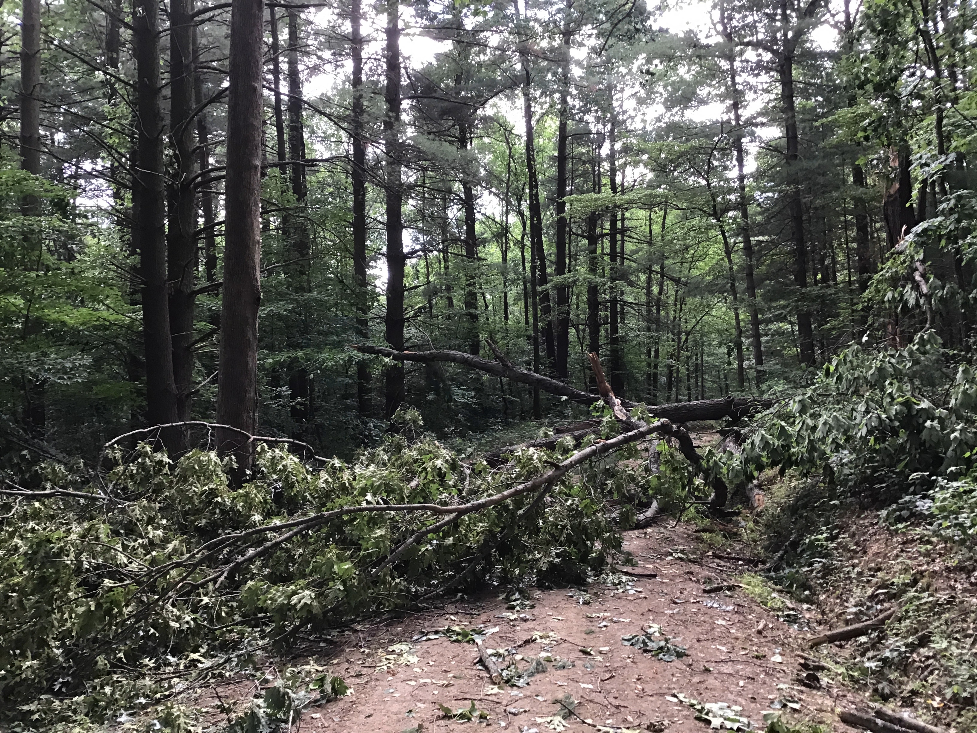
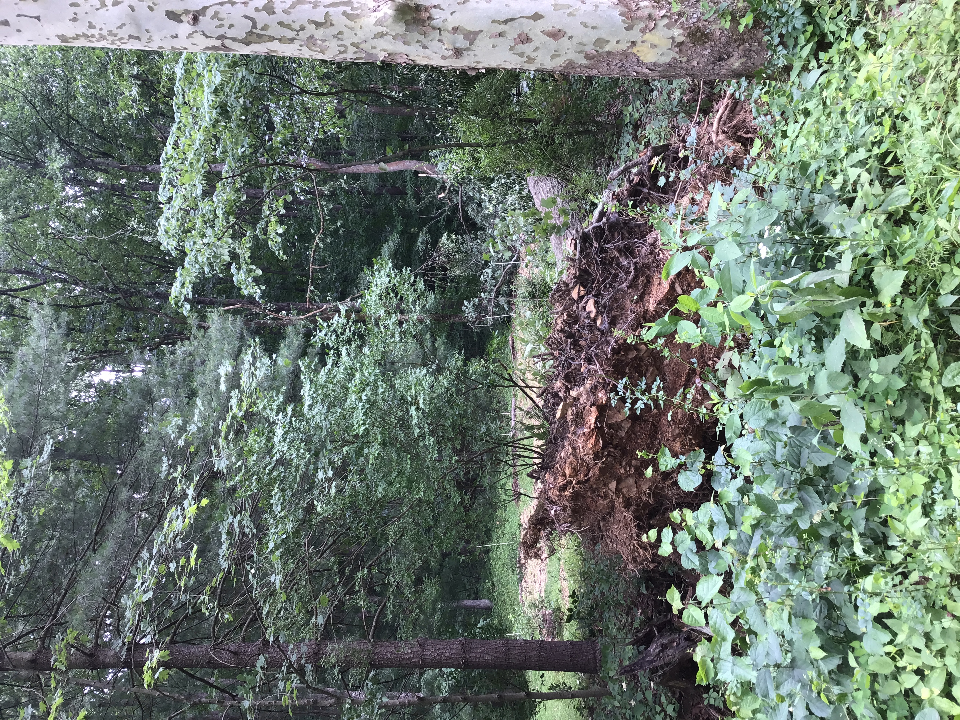
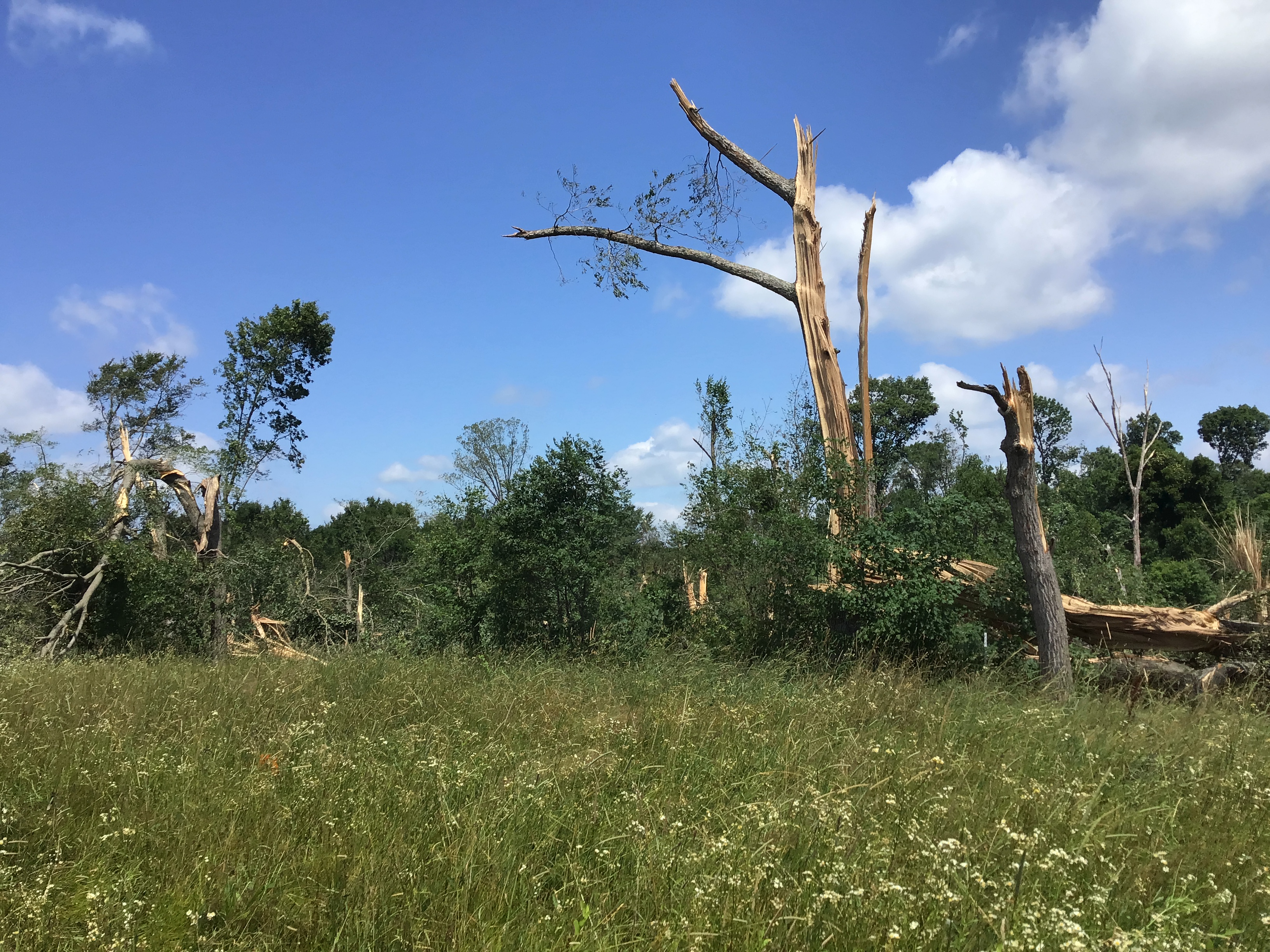
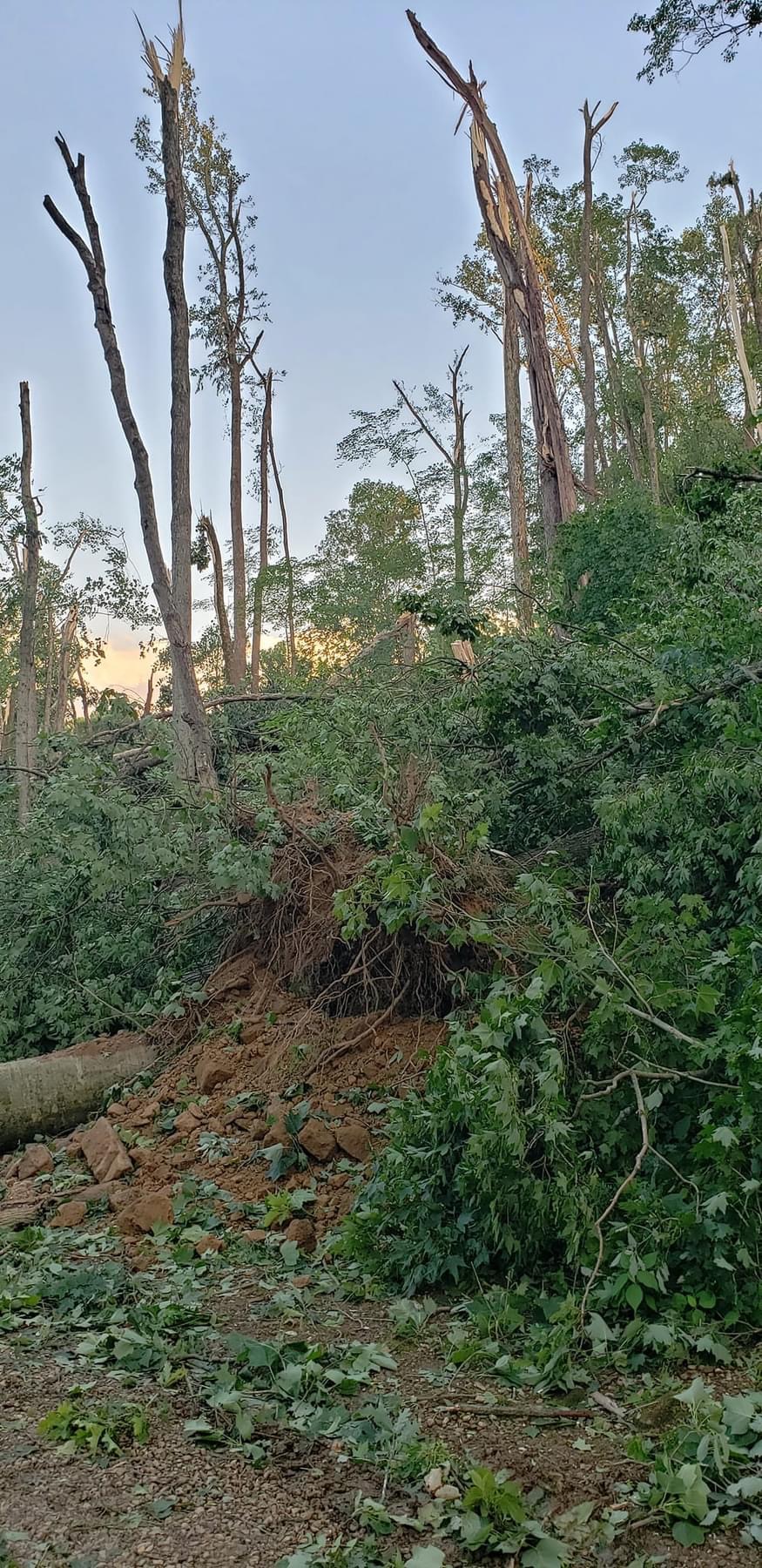
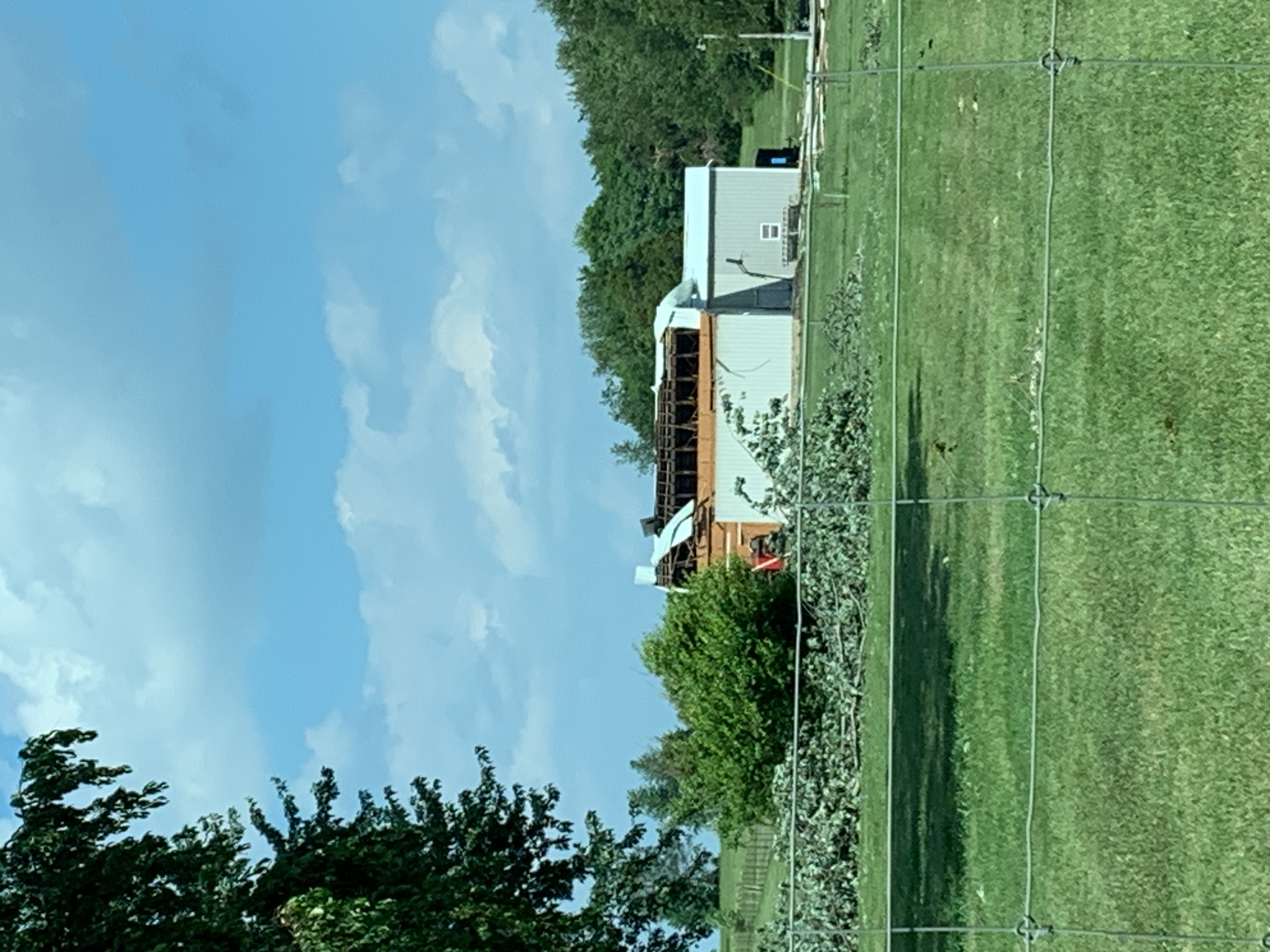
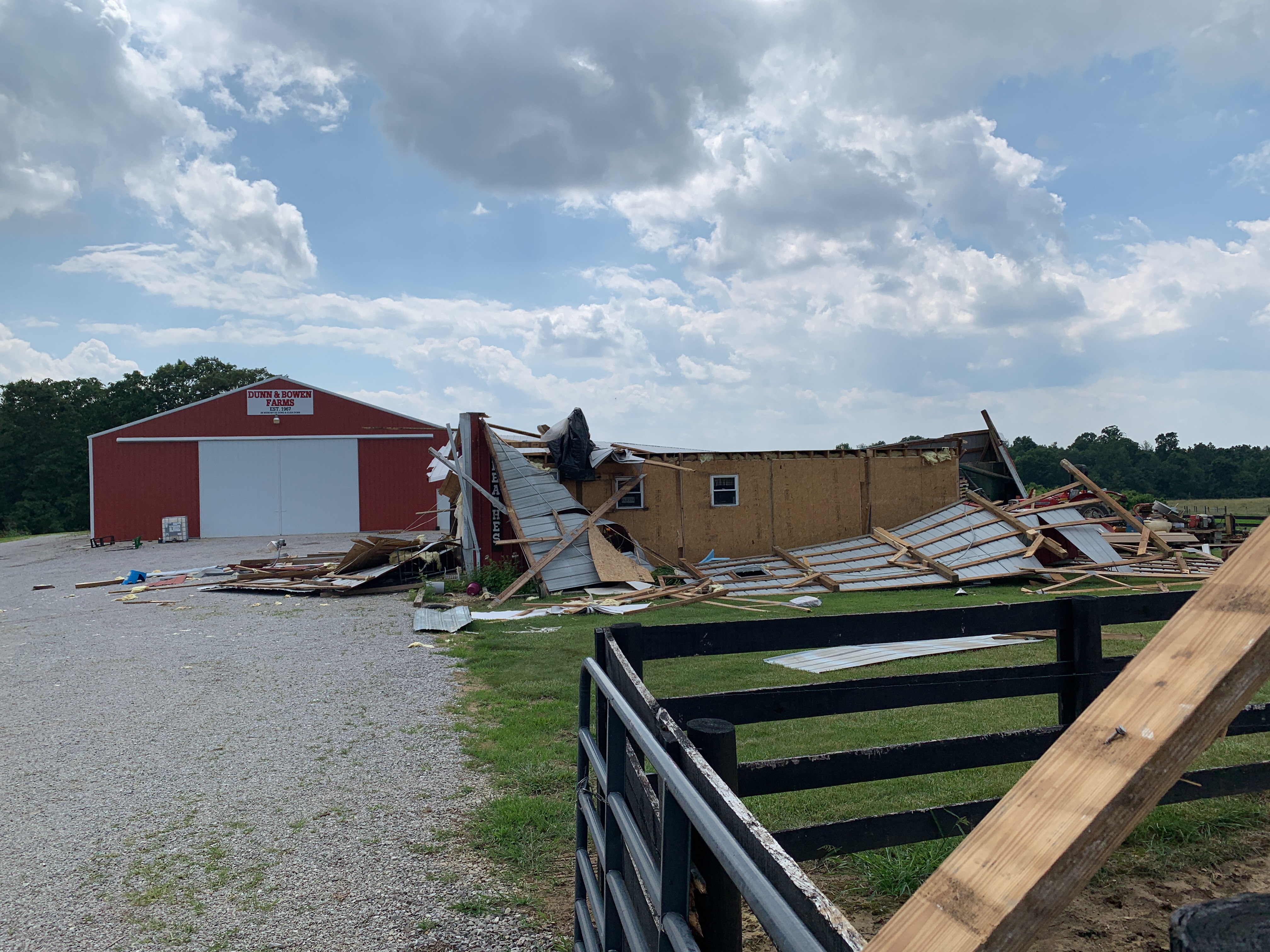
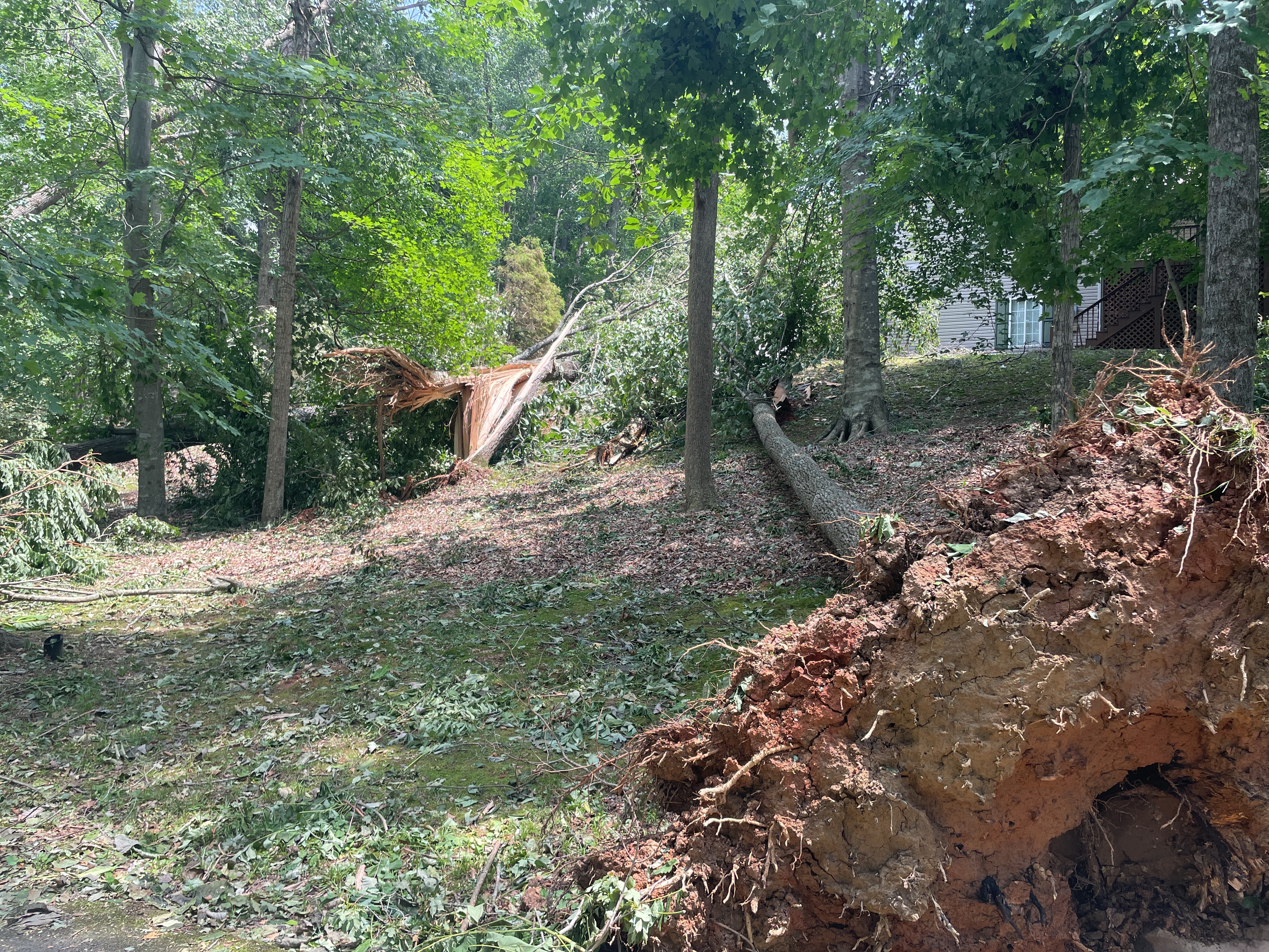
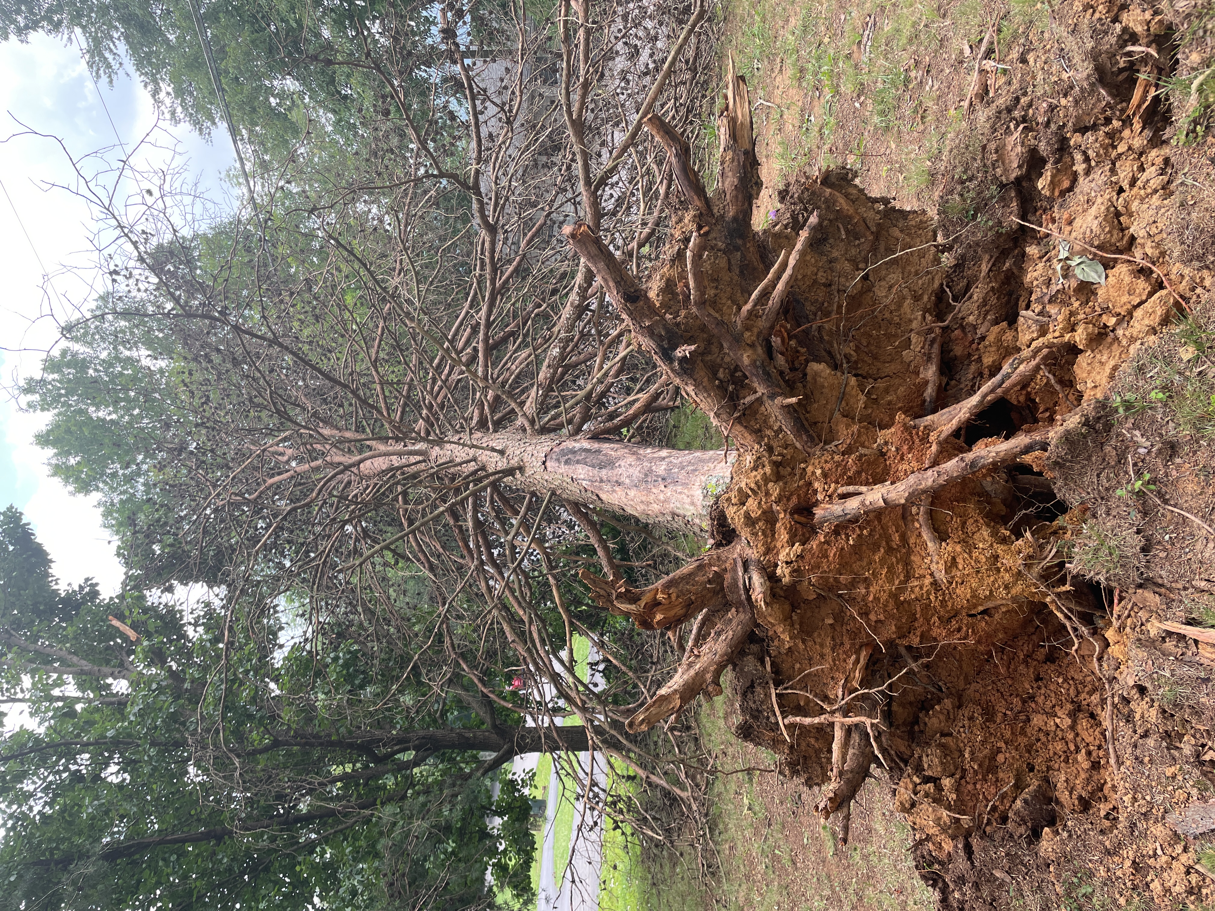
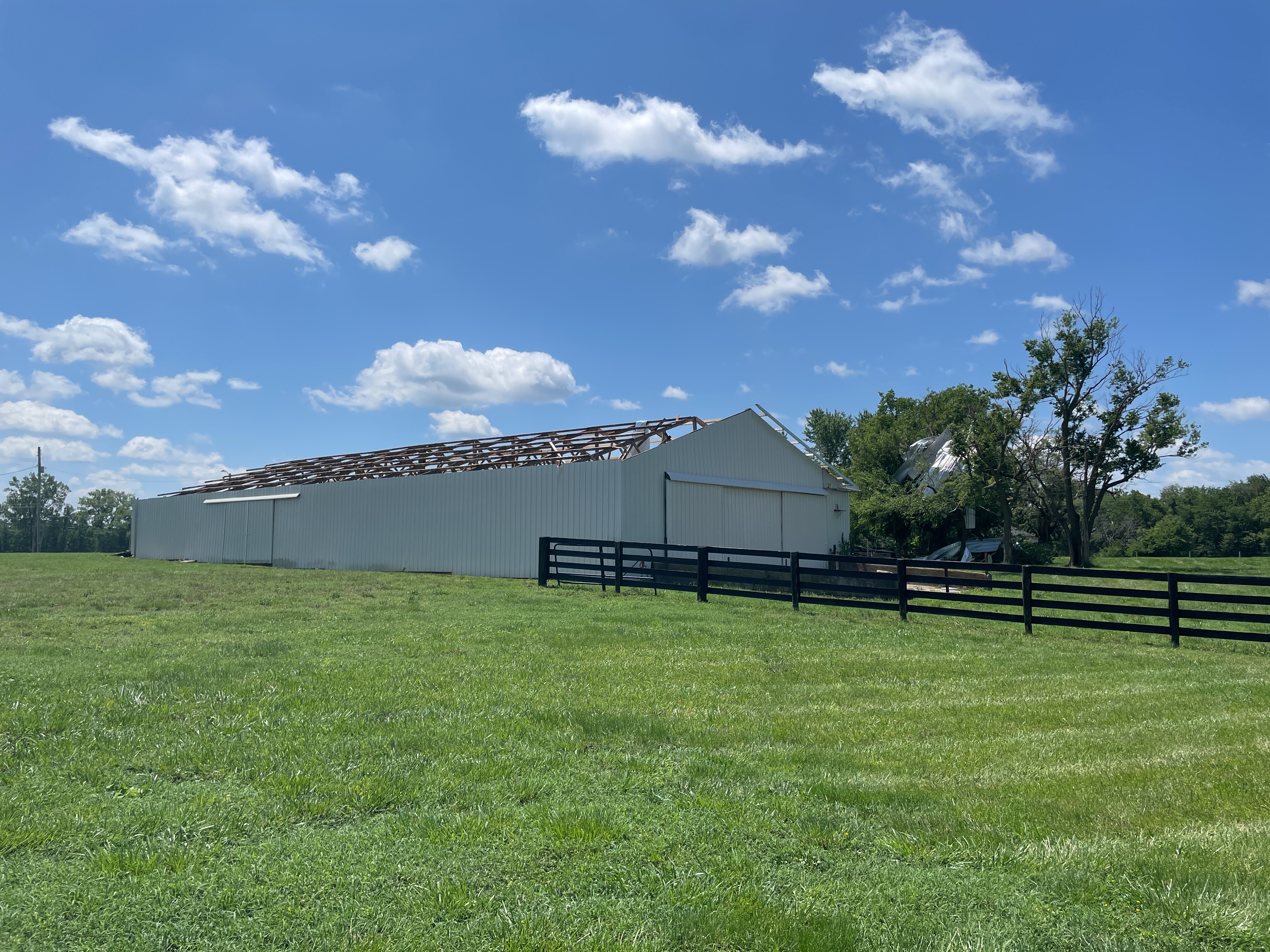
On the night of June 25th, 2023, strong thunderstorms moved through the region bringing large hail, winds up to 110mph, and a few tornadoes. NWS surveyed the damage for three days. With complex storm types and storm motions, determining exactly what occurred was not a simple task for the survey teams. |
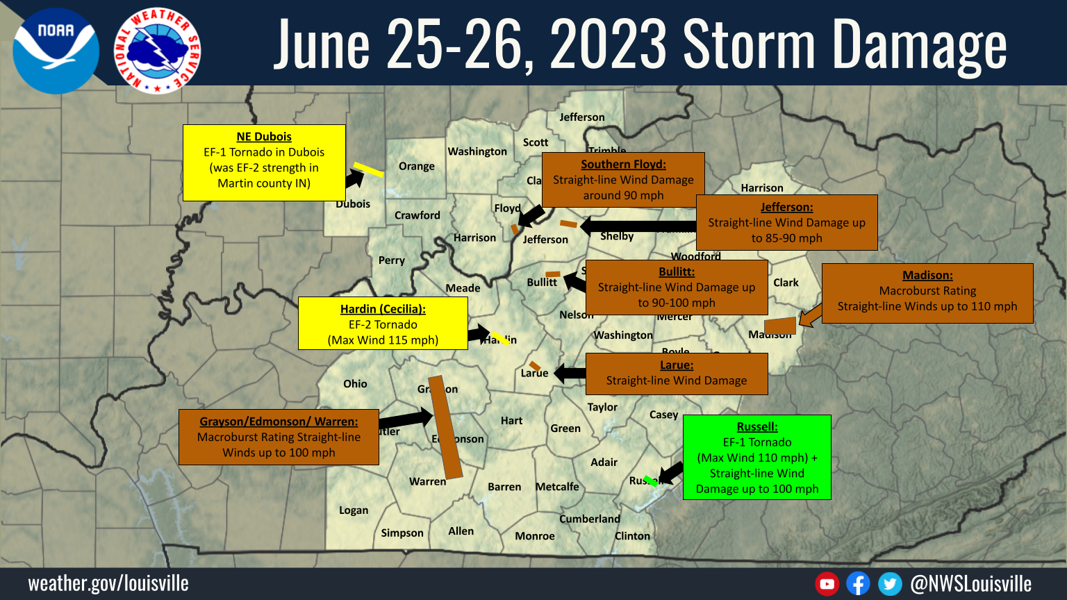 Summary of June 25-26, 2023 Storm Damage |
 |
 |
 |
| Giant Hail in French Lick, IN Courtesy of Sandy Hercamp |
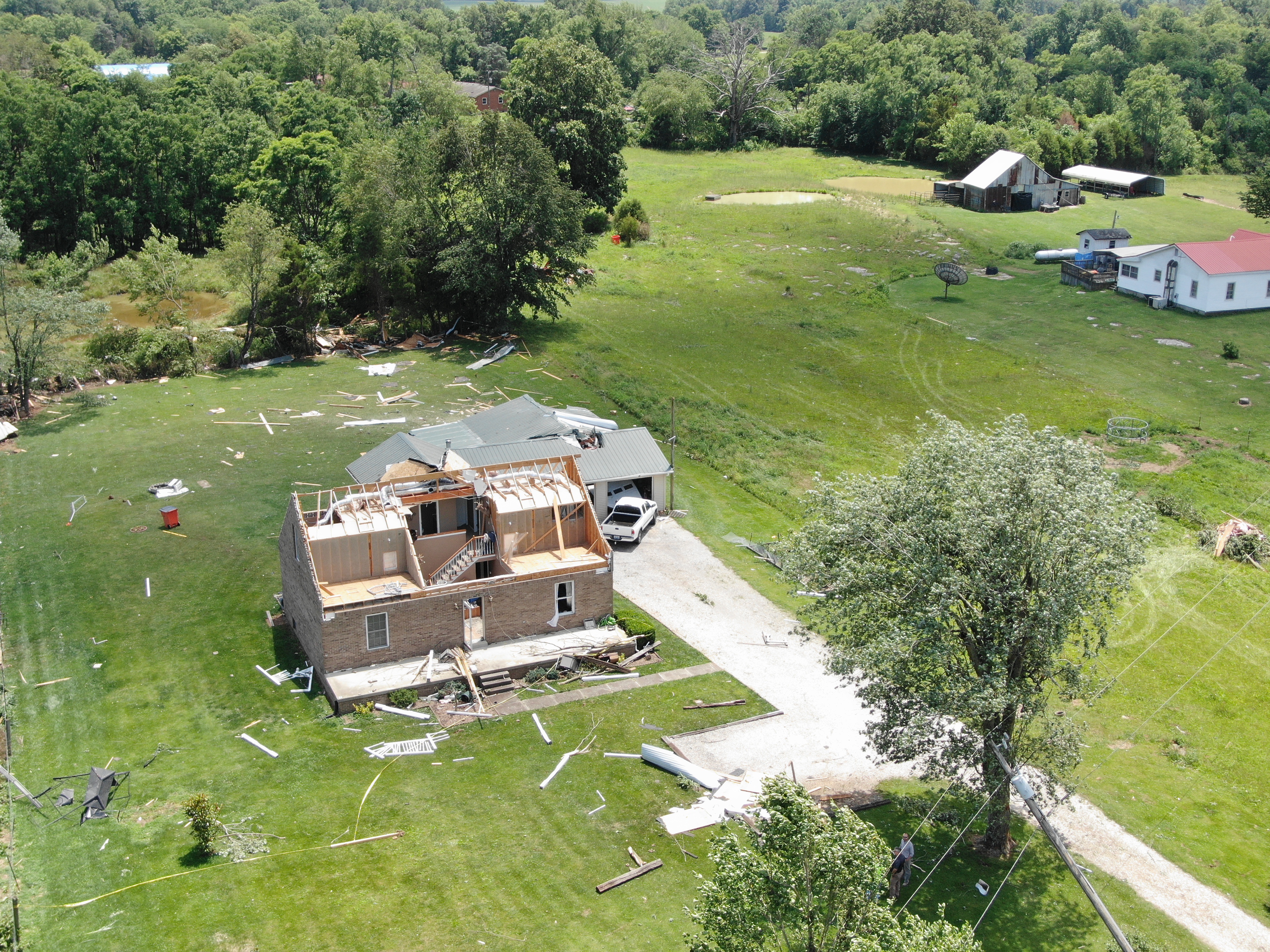
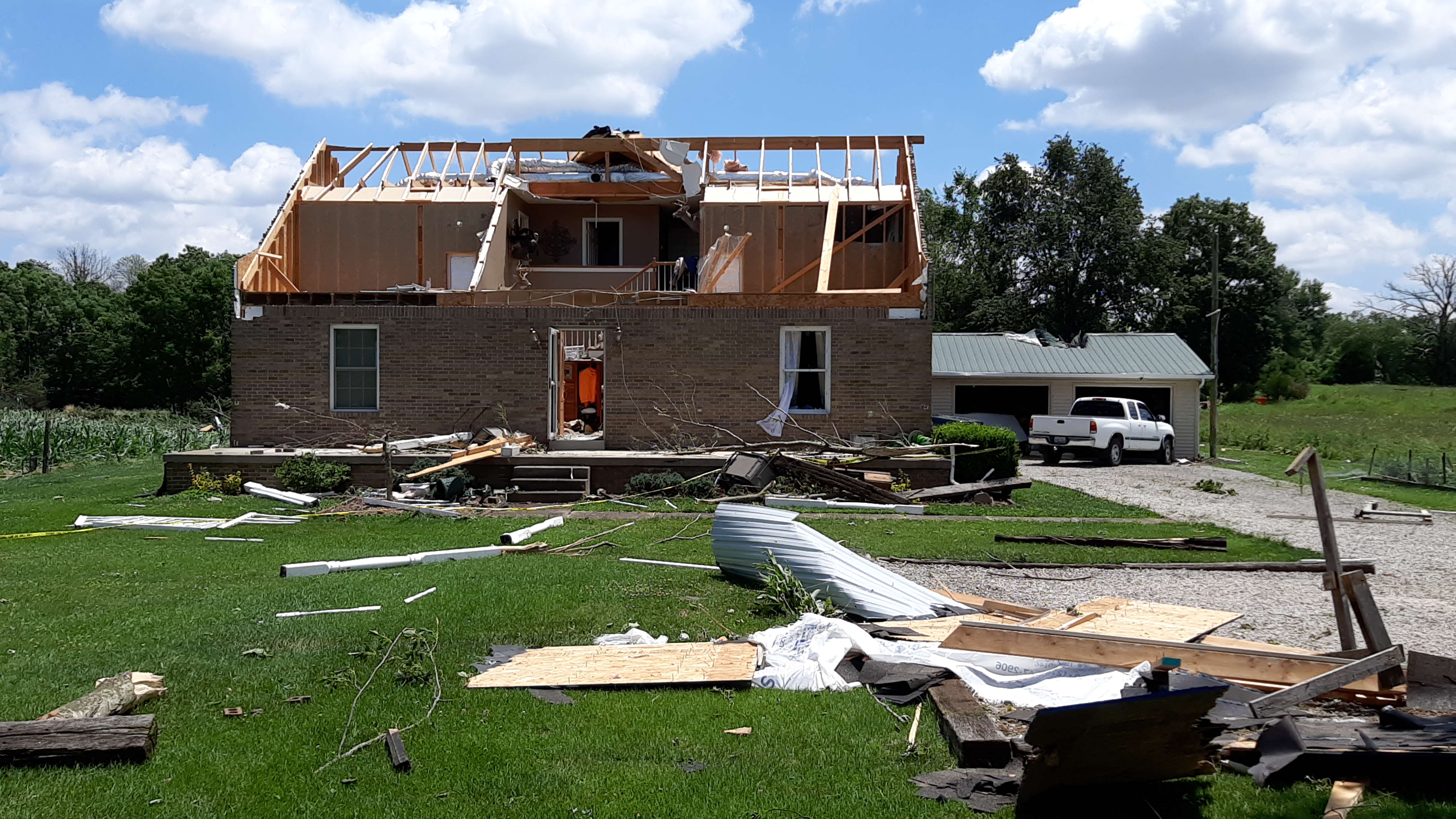
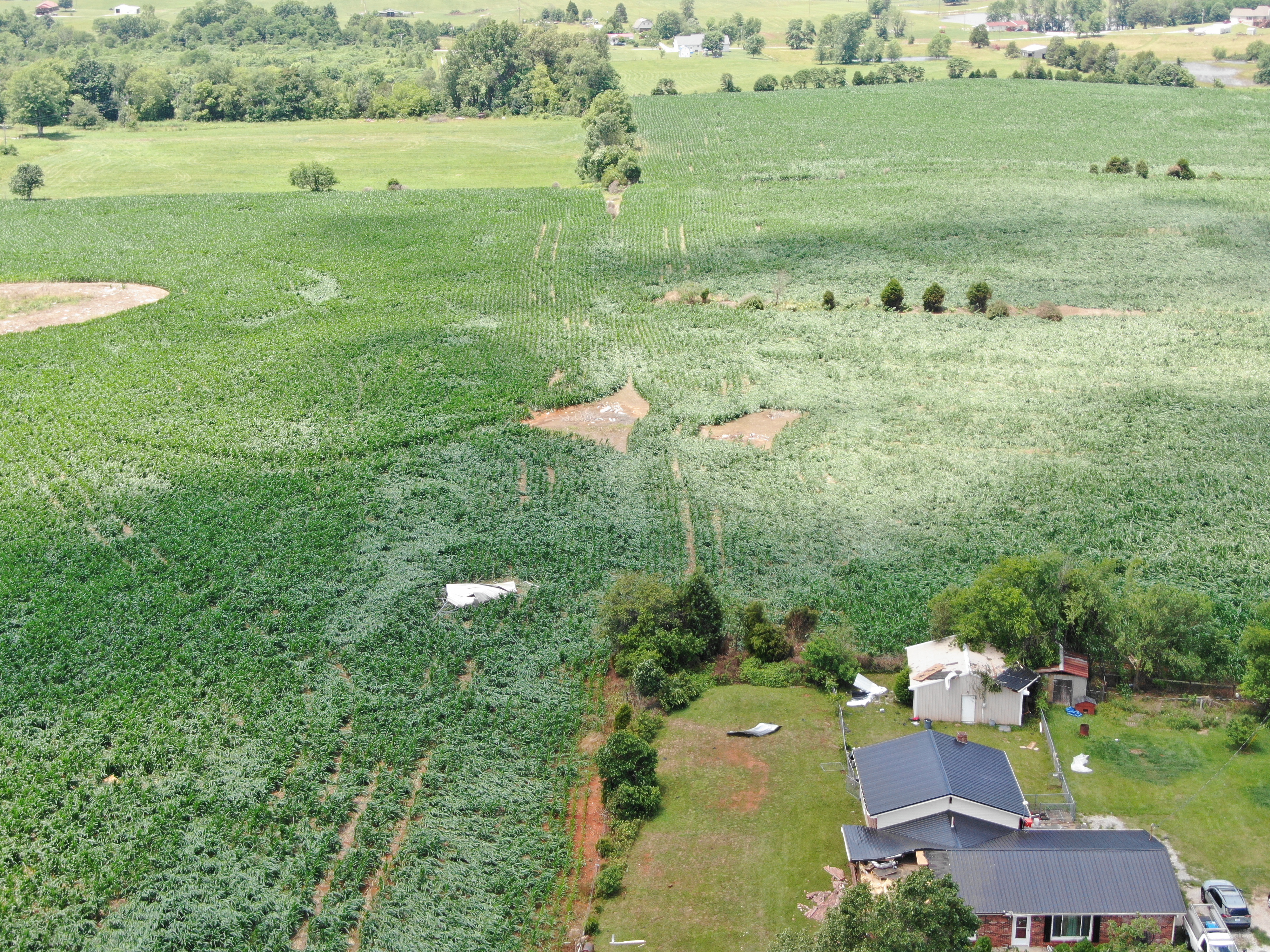
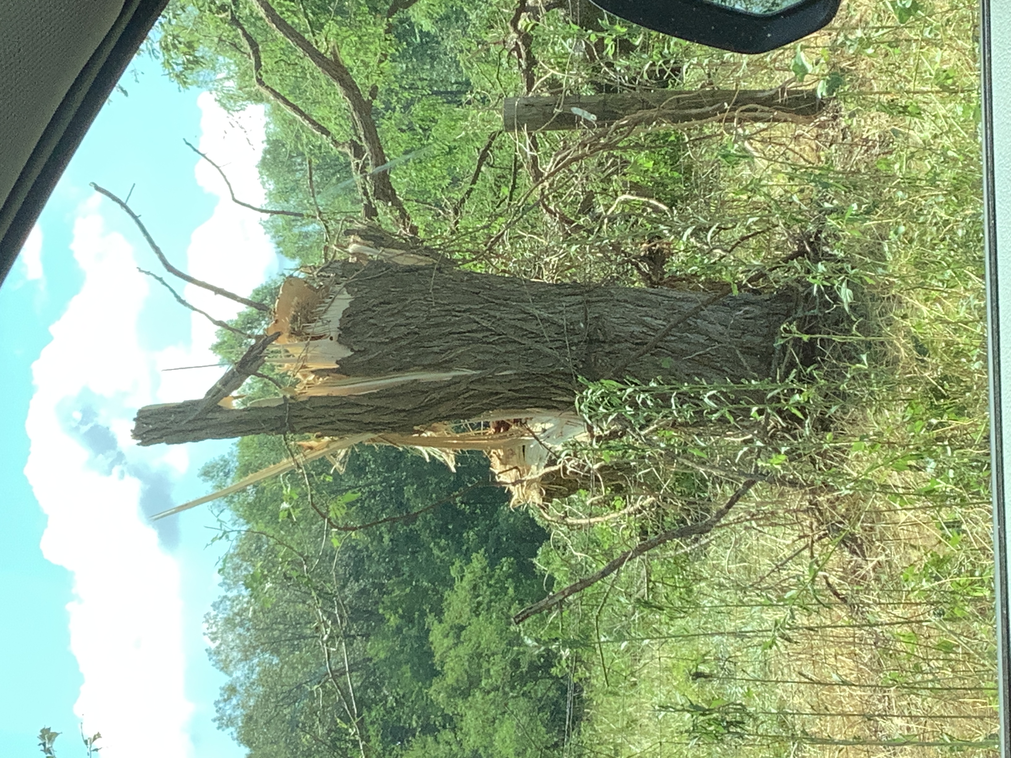
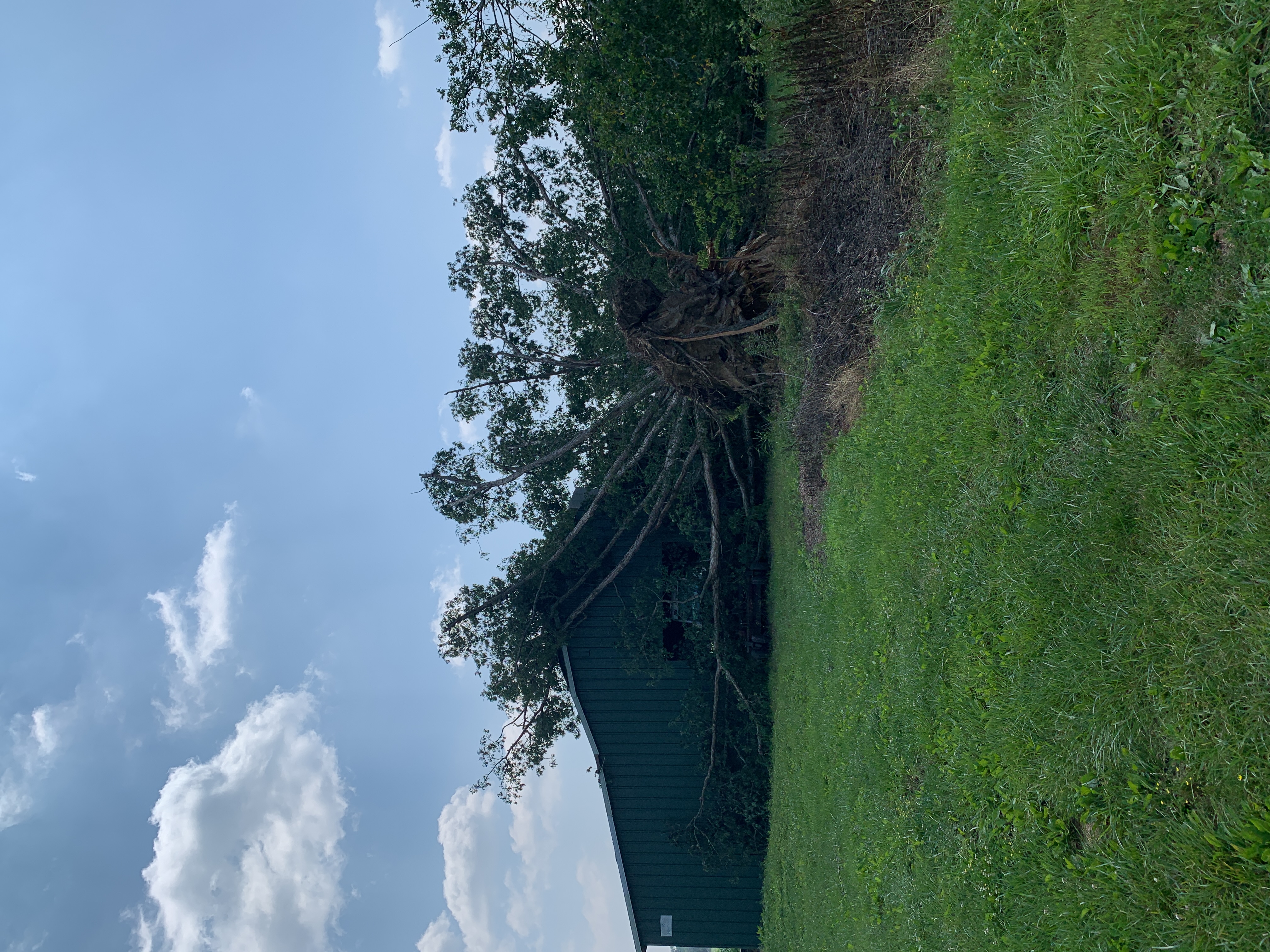
EF2 Tornado damage in Hardin County | Wind damage from Russell County |
Tornadoes
Interactive Damage Survey Map - Zoom in and click the points to see damage information and pictures. All damage points are preliminary at this time. Performance of this map may be slow due to heavy internet traffic. **Zoom in to see very small, brief tornadoes.**

|
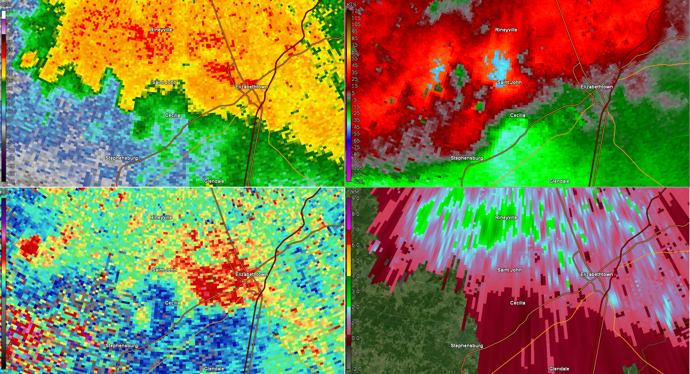
Tornado - Cecilia, KY
Track Map 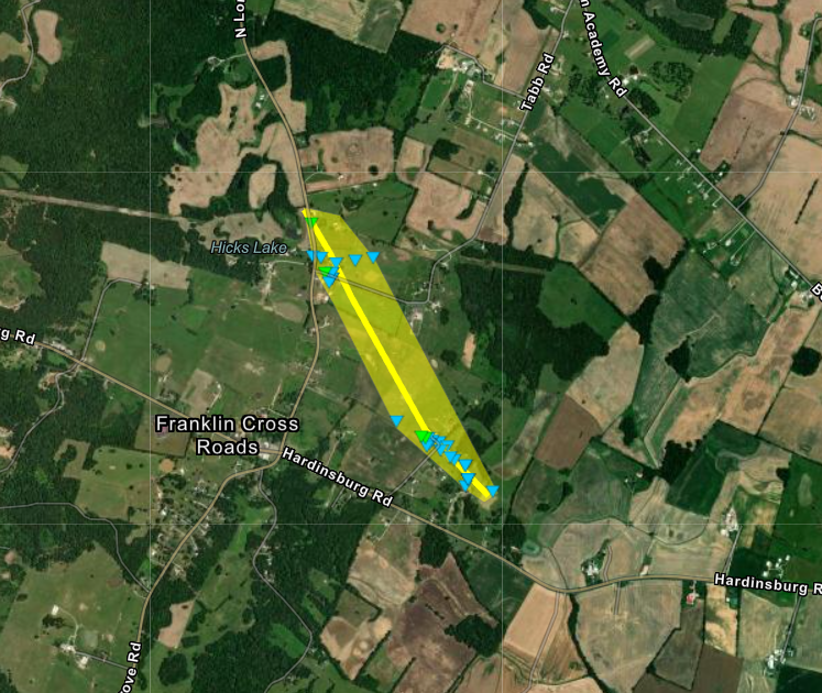
Downloadable KMZ File |
||||||||||||||||
|
||||||||||||||||
|
Tornado - Hillham
Track Map 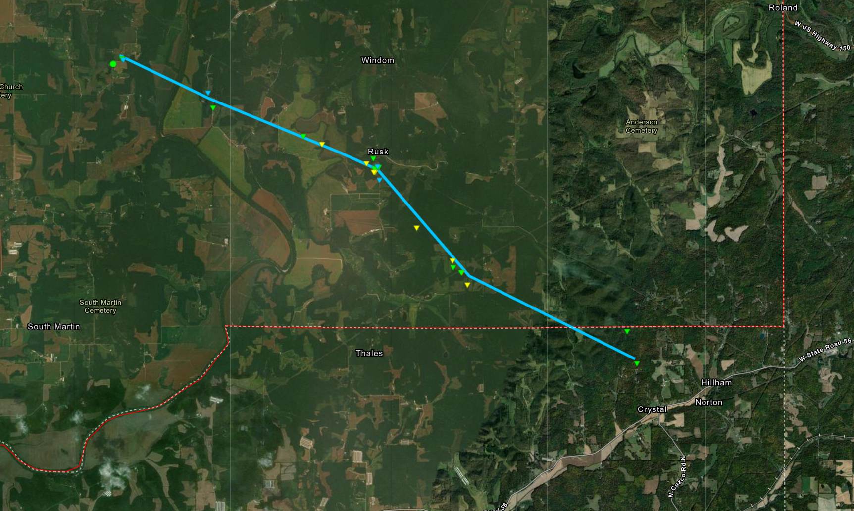
Downloadable KMZ File |
||||||||||||||||
|
||||||||||||||||
|
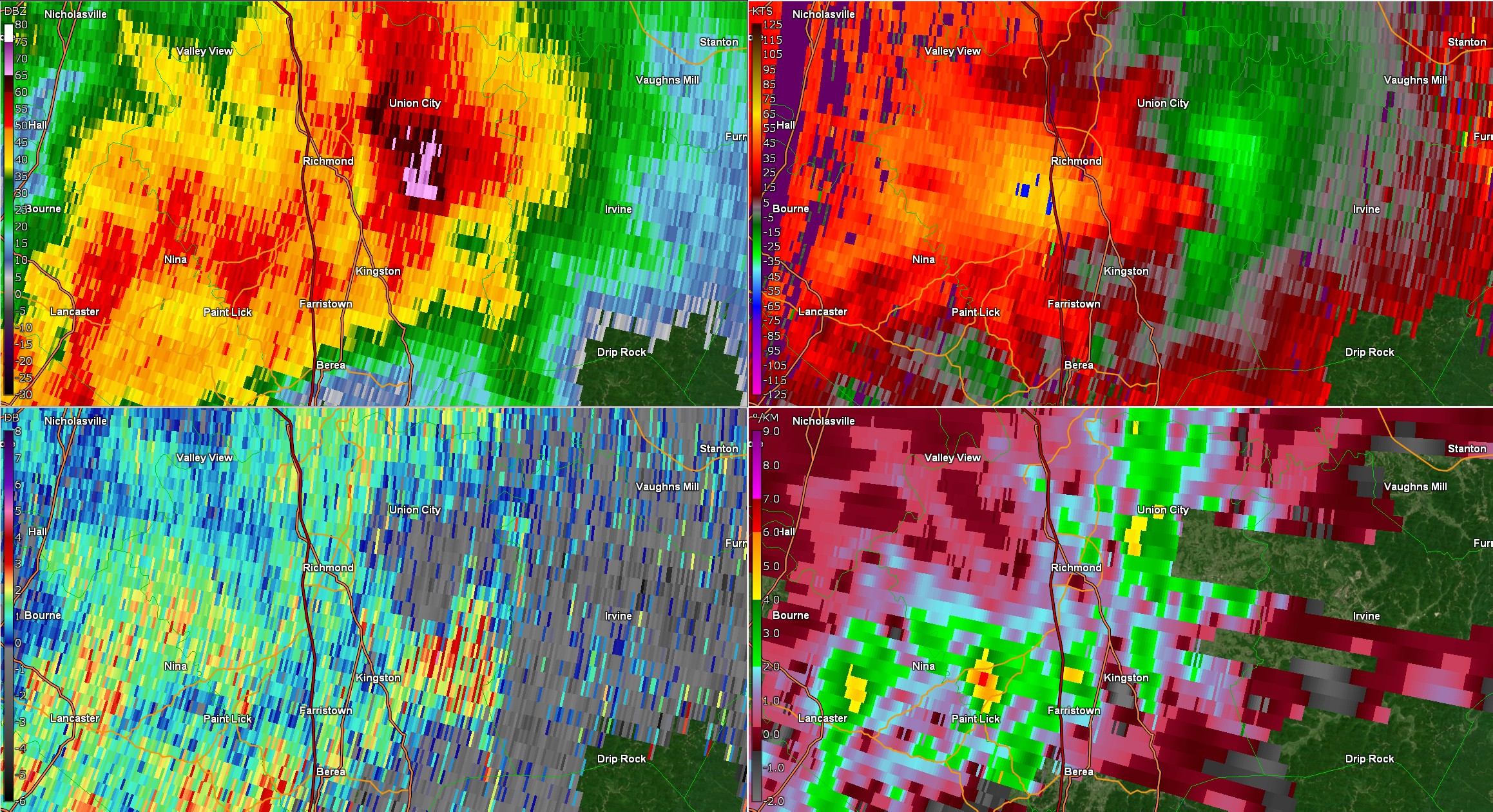
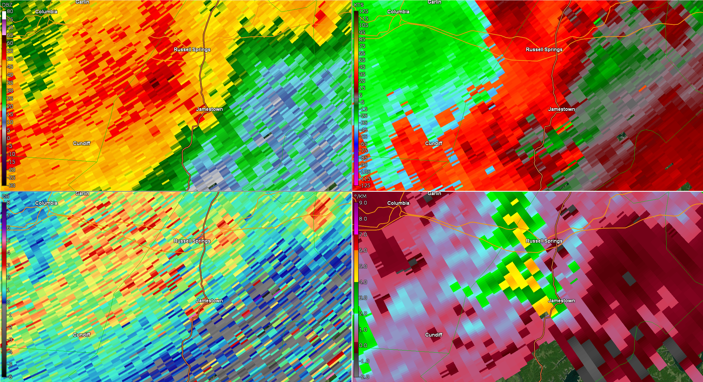
Tornado - Jamestown, KY
Track Map 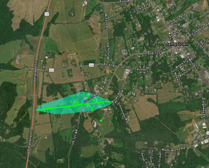
Downloadable KMZ File |
||||||||||||||||
|
||||||||||||||||
The Enhanced Fujita (EF) Scale classifies tornadoes into the following categories:
| EF0 Weak 65-85 mph |
EF1 Moderate 86-110 mph |
EF2 Significant 111-135 mph |
EF3 Severe 136-165 mph |
EF4 Extreme 166-200 mph |
EF5 Catastrophic 200+ mph |
 |
|||||
Wind:
|
Macroburst - Richmond, KY
Track Map 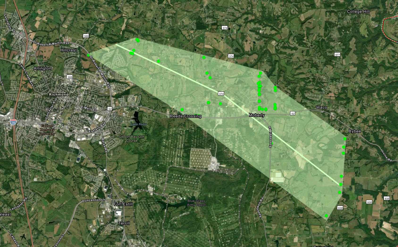
Downloadable KMZ File |
||||||||||||||
|
||||||||||||||
|
Macroburst
Track Map 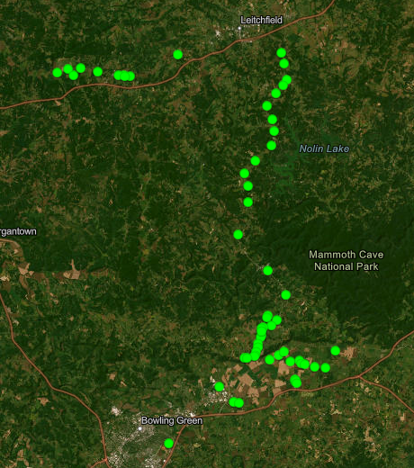
Downloadable KMZ File |
||||||||||||||
|
||||||||||||||
|
Straight-Line Wind - Jamestown, KY
Track Map 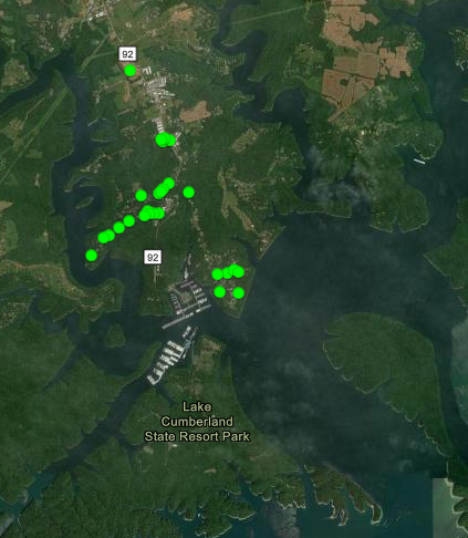
Downloadable KMZ File |
||||||||||||||
|
||||||||||||||
|
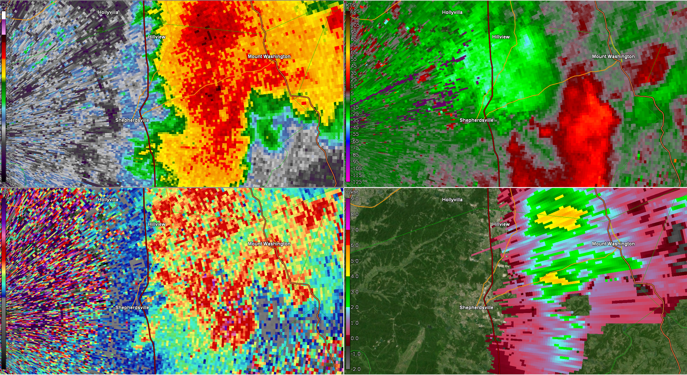
Straight-Line Wind - Shepherdsville, KY
Track Map 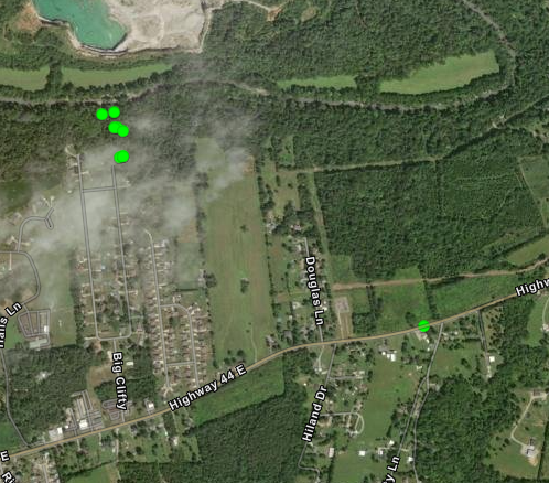
Downloadable KMZ File |
||||||||||||||
|
||||||||||||||
|
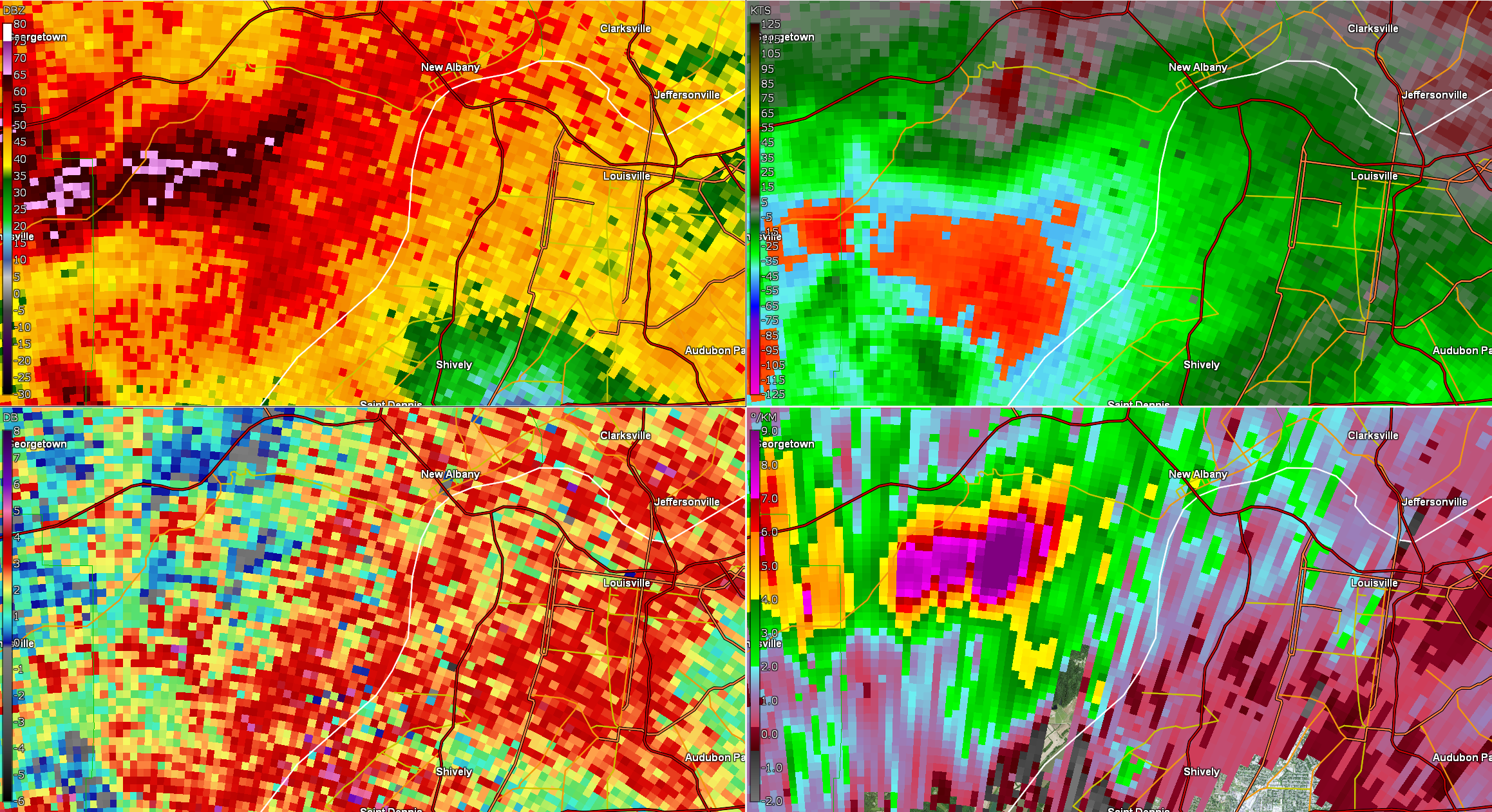
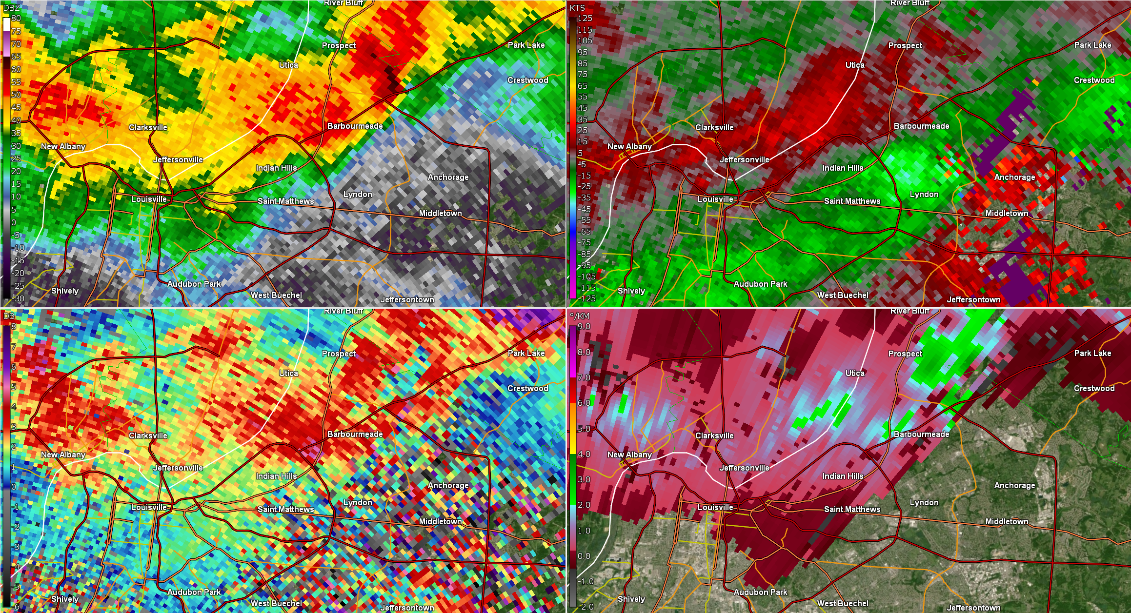
Straight-Line Wind - New Albany, IN
Track Map 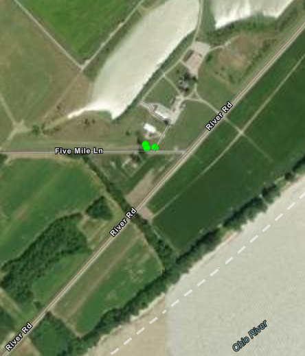
Downloadable KMZ File |
||||||||||
|
||||||||||
|
Straight-Line Wind - Lyndon, KY
Track Map 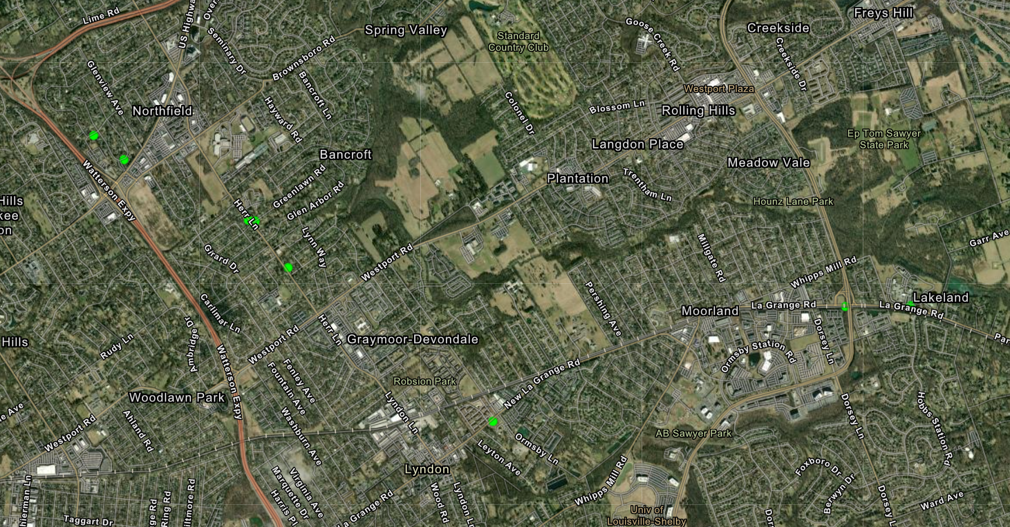
Downloadable KMZ File |
||||||||||
|
||||||||||
|
Straight-Line Wind - Hodgenville, KY
Track Map 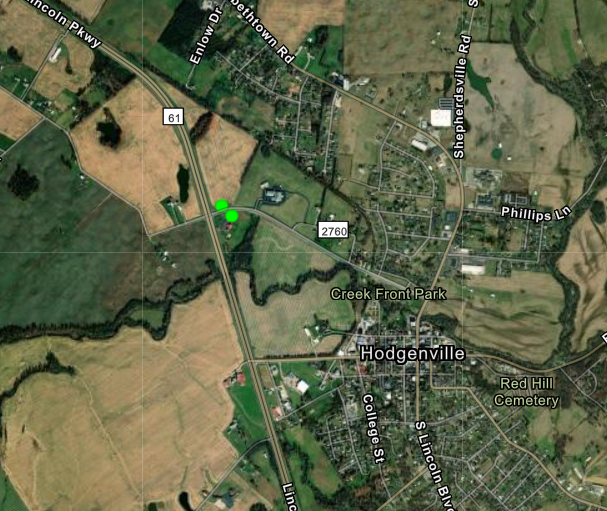
Downloadable KMZ File |
||||||||||
|
||||||||||
|
Straight-Line Wind - Breckinridge, IN
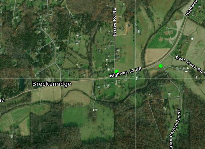
Downloadable KMZ File |
||||||||||
|
||||||||||
Hail:
|
 |
 |
 |
|
Larger than apple sized hail from French Lick, IN Courtesy of Sandy Hercamp via Marc Weinberg |
Large Hail from French Lick, IN Courtesy of Emily Goodman |
Hail Damage from Richmond, KY Courtesy of Tim Webb |
Quarter Sized Hail from Louisville, KY Courtesy of Riley Pfeiffer |
Radar
 |
 |
 |
 |
| Bullitt County Straight-line Wind | Dubois County Tornado | Floyd County Straight-line Wind | Hardin County Tornado |
 |
 |
 |
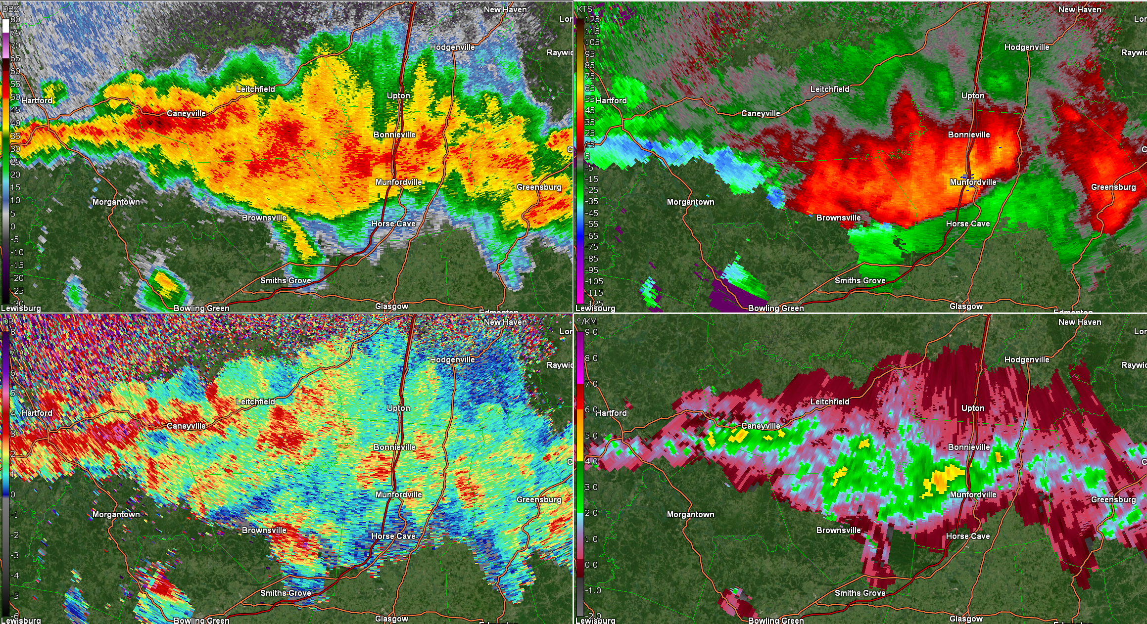 |
| Jefferson County Straight-line Wind | Madison County Macroburst | Russell County Tornado | Grayson/Edmonson/Warren County Macroburst |
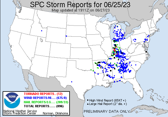
Storm Reports
Preliminary Local Storm Report...Summary
National Weather Service Louisville KY
624 PM EDT Wed Jun 28 2023
..TIME... ...EVENT... ...CITY LOCATION... ...LAT.LON...
..DATE... ....MAG.... ..COUNTY LOCATION..ST.. ...SOURCE....
..REMARKS..
0828 PM Hail 2 E Buckner 38.38N 85.40W
06/25/2023 E1.50 inch Oldham KY Public
Delayed report. Also had a medium size tree
fall across power lines in the 3100 block of
Pin Oak Dr. Hail came down laterally for at
least 3 to 4 minutes. Time estimated from
radar matching up hail core with likely
winds.
1000 AM Tstm Wnd Dmg 4 SE Linwood 37.30N 85.71W
06/25/2023 Hart KY Emergency Mngr
Tree down over Davis Bend Road.
1007 AM Tstm Wnd Dmg 3 SSE Pierce 37.14N 85.61W
06/25/2023 Green KY Emergency Mngr
Tree down over HWY 729 in southern Green
County.
1032 AM Tstm Wnd Dmg 1 ENE Cecilia 37.67N 85.93W
06/25/2023 Hardin KY Public
Numerous trees down and limbs snapped North
Black Branch Rd in Elizabethtown.
0828 PM Tstm Wnd Dmg 1 E Lyndon 38.26N 85.57W
06/25/2023 Jefferson KY NWS Employee
Large tree down on a house.
1018 PM Tstm Wnd Dmg 1 W Deanefield 37.66N 86.84W
06/25/2023 Ohio KY Public
Corrects previous tornado report from 1 W
Deanefield. Roof damage. Tree damage, some
uprooted. Along Collier Rd. Time estimated
based off radar.
1031 PM Tstm Wnd Dmg 3 W Elizabethtown 37.71N 85.92W
06/25/2023 Hardin KY Public
Delayed report. 2 barns with trusses taken
off the roof on Franklin Ln. Damage pointed
southward. Time estimate from when the power
went out.
0555 PM Hail 1 E Ramsey 38.32N 86.13W
06/25/2023 E2.00 inch Harrison IN Public
Report from mPING: Hen Egg (2.00 in.).
1000 PM Hail 3 W Redhouse 37.82N 84.31W
06/25/2023 E1.50 inch Madison KY Public
1049 PM Flood 4 S Lexington 37.98N 84.51W
06/25/2023 Fayette KY Amateur Radio
A few inches of water in an apartment
parking lot. East Hickman Creek out of its
banks.
0450 PM Hail Hillham 38.52N 86.70W
06/25/2023 E1.75 inch Dubois IN Public
Golf ball sized hail, trees down, loud
roaring sound with wind. Time estimated from
radar data for the hail core. Report time
was 5 PM, but assumed the damage happened
earlier.
0455 PM Hail French Lick 38.55N 86.62W
06/25/2023 E1.00 inch Orange IN NWS Employee
at the French Lick Resort.
0456 PM Hail French Lick 38.55N 86.62W
06/25/2023 E2.00 inch Orange IN Broadcast Media
Picture relayed from social media.
0456 PM Hail West Baden Springs 38.57N 86.62W
06/25/2023 E3.00 inch Orange IN Public
0522 PM Hail Marengo 38.37N 86.34W
06/25/2023 E1.50 inch Crawford IN Trained Spotter
0524 PM Hail French Lick 38.55N 86.62W
06/25/2023 E2.75 inch Orange IN Broadcast Media
0529 PM Hail 1 WNW Abydel 38.57N 86.57W
06/25/2023 M2.50 inch Orange IN Trained Spotter
2.5 inch hail fell at a storm spotter home.
0529 PM Hail Huntingburg 38.30N 86.96W
06/25/2023 E1.00 inch Dubois IN Public
Quarter sized hail fell.
0535 PM Hail 3 NW Syria 38.61N 86.44W
06/25/2023 M1.00 inch Orange IN Public
0541 PM Hail 2 WNW Maltersville 38.36N 86.92W
06/25/2023 E1.75 inch Dubois IN Emergency Mngr
Dubois County Highway Garage.
0549 PM Hail 1 NW Ramsey 38.32N 86.16W
06/25/2023 E2.00 inch Harrison IN Public
0558 PM Hail 1 W Georgetown 38.30N 85.99W
06/25/2023 E1.00 inch Floyd IN Public
0600 PM Hail 1 NNE Floyds Knobs 38.33N 85.86W
06/25/2023 E0.25 inch Floyd IN Public
0623 PM Hail 1 NW North Madison 38.78N 85.41W
06/25/2023 E1.50 inch Jefferson IN Public
0623 PM Hail 2 SSE Louisville 38.23N 85.75W
06/25/2023 E1.00 inch Jefferson KY Public
Video of quarter sized hail.
0625 PM Hail Madison 38.75N 85.38W
06/25/2023 E1.75 inch Jefferson IN Trained Spotter
0626 PM Hail 2 W North Madison 38.77N 85.43W
06/25/2023 E1.00 inch Jefferson IN Public
0635 PM Hail 2 NW Lanesville 38.27N 86.01W
06/25/2023 E1.75 inch Harrison IN Public
Report from mPING: Golf Ball (1.75 in.).
Time estimated from radar.
0636 PM Hail 2 NNE Hillview 38.09N 85.67W
06/25/2023 E1.00 inch Jefferson KY Broadcast Media
0636 PM Hail 1 SE Georgetown 38.29N 85.96W
06/25/2023 E1.25 inch Floyd IN Public
0636 PM Hail 2 SW Edwardsville 38.26N 85.94W
06/25/2023 E1.25 inch Floyd IN Public
Report from mPING: Half Dollar (1.25 in.).
0646 PM Hail 3 S Louisville 38.21N 85.76W
06/25/2023 E1.00 inch Jefferson KY Public
0646 PM Hail Shively 38.20N 85.81W
06/25/2023 E0.75 inch Jefferson KY Public
0649 PM Hail 2 SSW Highview 38.12N 85.64W
06/25/2023 E0.75 inch Jefferson KY NWS Employee
0650 PM Hail Shively 38.20N 85.81W
06/25/2023 E1.25 inch Jefferson KY Public
0652 PM Hail 1 ENE Pleasure Ridge Pa 38.16N 85.83W
06/25/2023 E1.50 inch Jefferson KY Public
0653 PM Hail 4 SSW Saint Matthews 38.20N 85.66W
06/25/2023 E0.25 inch Jefferson KY Public
0654 PM Hail 3 ESE Louisville 38.23N 85.71W
06/25/2023 E0.50 inch Jefferson KY Public
0656 PM Hail 3 NW Fairdale 38.14N 85.80W
06/25/2023 E1.00 inch Jefferson KY Public
Report from mPING: Quarter (1.00 in.).
0705 PM Hail Orleans 38.67N 86.45W
06/25/2023 E0.70 inch Orange IN Public
0709 PM Hail 1 E Mount Washington 38.05N 85.54W
06/25/2023 E0.88 inch Bullitt KY Public
0719 PM Hail 2 WSW Mount Washington 38.04N 85.59W
06/25/2023 E1.00 inch Bullitt KY Public
0723 PM Hail 1 SE Highgrove 37.99N 85.49W
06/25/2023 E0.70 inch Nelson KY Trained Spotter
0730 PM Hail 1 E Mount Washington 38.05N 85.54W
06/25/2023 E1.00 inch Bullitt KY Trained Spotter
0745 PM Hail 3 NW Syria 38.61N 86.44W
06/25/2023 M1.00 inch Orange IN Public
0814 PM Hail 1 SW Solon 38.49N 85.55W
06/25/2023 E1.00 inch Clark IN Public
Quarter sized hail in Vesta.
0823 PM Hail 1 SW Westport 38.48N 85.48W
06/25/2023 E1.00 inch Oldham KY Public
Report from mPING: Quarter (1.00 in.).
0825 PM Hail 1 NW Pewee Valley 38.32N 85.50W
06/25/2023 E0.75 inch Oldham KY Public
0832 PM Hail 1 SSE Crestwood 38.33N 85.47W
06/25/2023 E0.50 inch Oldham KY Broadcast Media
Between quarter and half dollar hail.
0835 PM Hail 2 SSE Buckner 38.36N 85.42W
06/25/2023 E1.00 inch Oldham KY NWS Employee
0847 PM Hail 1 E Fredonia 38.18N 86.38W
06/25/2023 E1.50 inch Crawford IN Public
0852 PM Hail 2 SSW Jeffersonville 38.28N 85.74W
06/25/2023 E1.25 inch Clark IN Public
Multiple reports of 1 to 1.25 inch sized
hail from social media.
0853 PM Hail 1 S Jeffersonville 38.28N 85.73W
06/25/2023 E1.00 inch Clark IN Public
Report from mPING: Quarter (1.00 in.).
0906 PM Hail 3 WSW New Middletown 38.15N 86.09W
06/25/2023 E1.25 inch Harrison IN Public
0906 PM Hail Jeffersontown 38.21N 85.56W
06/25/2023 E1.00 inch Jefferson KY Public
0908 PM Hail 2 E Peytona 38.19N 85.04W
06/25/2023 E1.00 inch Shelby KY Public
0910 PM Hail Fern Creek 38.16N 85.60W
06/25/2023 E1.00 inch Jefferson KY NWS Employee
0912 PM Hail 2 SE Fern Creek 38.13N 85.57W
06/25/2023 E1.00 inch Jefferson KY Public
0914 PM Hail 2 NE Harrisonville 38.10N 85.03W
06/25/2023 E1.50 inch Anderson KY Trained Spotter
Quarter to ping pong ball size hail
reported.
0917 PM Hail 2 ENE Wolf Creek 38.12N 86.35W
06/25/2023 E1.75 inch Meade KY Public
0920 PM Hail 2 ENE Mount Washington 38.06N 85.51W
06/25/2023 E1.00 inch Bullitt KY Public
0926 PM Hail Elk Creek 38.10N 85.37W
06/25/2023 E1.00 inch Spencer KY NWS Employee
0933 PM Hail 4 NNW Webster 37.93N 86.37W
06/25/2023 E1.00 inch Breckinridge KY Amateur Radio
0941 PM Hail Finchville 38.15N 85.32W
06/25/2023 E0.50 inch Shelby KY Public
1011 PM Hail 1 NNW Keene 37.95N 84.64W
06/25/2023 E0.88 inch Jessamine KY Emergency Mngr
1015 PM Hail 6 NE Nicholasville 37.95N 84.52W
06/25/2023 E1.00 inch Jessamine KY Public
1044 PM Hail 1 N Valley View 37.85N 84.43W
06/25/2023 E2.75 inch Madison KY Emergency Mngr
1045 PM Hail 1 NNW Richmond 37.75N 84.30W
06/25/2023 E1.50 inch Madison KY Public
1046 PM Hail 3 NW Richmond 37.77N 84.32W
06/25/2023 E2.50 inch Madison KY Public
1049 PM Hail 1 ESE Tonnieville 37.59N 85.78W
06/25/2023 E0.75 inch Larue KY Public
1050 PM Hail 3 SSE Redhouse 37.79N 84.25W
06/25/2023 E1.00 inch Madison KY Public
1052 PM Hail 3 WNW Waco 37.74N 84.21W
06/25/2023 E1.00 inch Madison KY Public
1057 PM Hail 3 SSE Redhouse 37.78N 84.25W
06/25/2023 E0.88 inch Madison KY Amateur Radio
Reports of hail breaking windows on Union
City Rd near Hackett Pike (ground covered in
Marble size hail) in Madison County and also
apartments near Robert E Martin Bypass.
1114 PM Hail 2 WNW Waco 37.74N 84.18W
06/25/2023 U0.25 inch Madison KY Amateur Radio
Ham operator reported windows broken in
house on Meadowbrook Rd near Moberly.
1119 PM Hail 2 NNW Webster 37.91N 86.35W
06/25/2023 E1.00 inch Breckinridge KY Public
1119 PM Hail 6 NNW Welchs Creek 37.43N 86.62W
06/25/2023 E1.00 inch Grayson KY Public
Report from mPING: Quarter (1.00 in.).
1120 PM Hail 6 NNW Welchs Creek 37.43N 86.62W
06/25/2023 E1.25 inch Grayson KY Public
1127 PM Hail Caneyville 37.43N 86.49W
06/25/2023 E1.00 inch Grayson KY Trained Spotter
0130 AM Hail 1 SE Halfway 36.79N 86.29W
06/26/2023 E1.00 inch Allen KY Public
Report from mPING: Quarter (1.00 in.). Time
estimated from radar.
0446 PM Tornado 1 W Hillham 38.52N 86.72W
06/25/2023 Dubois IN NWS Storm Survey
Location where EF1 tornado lifted in Dubois
County.
1027 PM Tornado 3 N Stephensburg 37.68N 86.01W
06/25/2023 Hardin KY NWS Storm Survey
Tornado formed as a cluster of storms
briefly interacted with an old outflow
boundary. Caused damage to numerous trees,
and its path was noticeable in a field of
corn. Worst damage was to two properties on
Basham Lane, with one house having its roof
peeled off. Start time was based off of
eyewitness account of when power went out at
Tabb Rd.
0530 PM Tstm Wnd Dmg 1 ENE Huntingburg 38.30N 86.95W
06/25/2023 Dubois IN Emergency Mngr
2 trees down over Clay Street in
Huntingburg.
0615 PM Tstm Wnd Dmg 3 NE Bridgeport 38.21N 85.88W
06/25/2023 Floyd IN Emergency Mngr
time estimated - Significant wind damage.
0618 PM Tstm Wnd Dmg 1 S New Albany 38.29N 85.82W
06/25/2023 Floyd IN Fire Dept/Rescue
Tree down on I-64 near exit 122.
0620 PM Tstm Wnd Dmg Depauw 38.34N 86.22W
06/25/2023 Harrison IN Public
Picture of uprooted tree relayed on social
media.
0625 PM Tstm Wnd Dmg 2 NNE Lanesville 38.27N 85.96W
06/25/2023 Floyd IN Public
Multiple trees uprooted along tree line.
Time of report in mping data base was 630.
Estimated 625 from radar data, though it
could have been from an earlier storm just
before 6 as well.
0630 PM Tstm Wnd Dmg 2 SW Lanesville 38.22N 86.01W
06/25/2023 Harrison IN Public
Report from mPING: Multiple trees damaged.
Time estimated based on radar.
0633 PM Tstm Wnd Dmg 2 WNW Lyndon 38.27N 85.62W
06/25/2023 Jefferson KY Public
Damaged trees and large limbs snapped.
0707 PM Tstm Wnd Dmg 3 NE Shepherdsville 38.02N 85.67W
06/25/2023 Bullitt KY NWS Storm Survey
NWS Storm Survey estimated winds of 90-100
mph along Hwy 44 and near Big Clifty and
Gibraltar Drive. Numerous trees felled,
including one with significant damage on a
home. Timing is based on eye witness
accounts, as there were multiple warned
storms that went through this region that
night.
0708 PM Tstm Wnd Dmg 3 ESE Shepherdsville 37.98N 85.66W
06/25/2023 Bullitt KY Public
Report from mPING: Multiple trees damaged.
Time estimated from radar.
0709 PM Tstm Wnd Dmg 1 SSE Shepherdsville 37.98N 85.71W
06/25/2023 Bullitt KY Public
Tree down on Cedar Grove Road in Bullitt
County.
0709 PM Tstm Wnd Dmg 5 E Shepherdsville 38.00N 85.63W
06/25/2023 Bullitt KY Trained Spotter
Trees down and minor damage to home.
0710 PM Tstm Wnd Dmg 5 E Shepherdsville 38.00N 85.63W
06/25/2023 Bullitt KY Public
Multiple trees down. Several snapped like
toothpicks. NWS Storm Survey in that
vicinity showed 90-100 mph straight lined
winds and this matches up along that area.
Time estimated from radar.
0815 PM Tstm Wnd Dmg Jeffersonville 38.30N 85.73W
06/25/2023 Clark IN Public
Firework tent damage and a tree fallen onto
a power line near the White Castle.
0815 PM Tstm Wnd Dmg 2 E Jeffersonville 38.30N 85.69W
06/25/2023 Clark IN Public
Report from mPING: Trees down. Time
estimated from radar.
0816 PM Tstm Wnd Dmg 1 NNW Prospect 38.37N 85.62W
06/25/2023 Jefferson KY NWS Employee
Trees down on Rose Island Rd near the
Jefferson county and Oldham county line per
former National Weather Service Employee.
0826 PM Tstm Wnd Dmg 2 N Saint Matthews 38.28N 85.64W
06/25/2023 Jefferson KY Broadcast Media
Trees down.
0830 PM Tstm Wnd Dmg 1 WSW Lyndon 38.26N 85.60W
06/25/2023 Jefferson KY Broadcast Media
Large limbs down and power outages between
Lyndon and Middletown.
0901 PM Tstm Wnd Dmg 1 N Finchville 38.16N 85.32W
06/25/2023 Shelby KY Public
Trees down.
0910 PM Tstm Wnd Dmg 2 NE Stamping Ground 38.29N 84.66W
06/25/2023 Scott KY Emergency Mngr
Large tree branches snapped. Small shed
tipped over.
0917 PM Tstm Wnd Dmg 2 SE Alton 38.07N 84.91W
06/25/2023 Anderson KY Trained Spotter
Tree and fence damage occurred at several
locations across the north side of
Lawrenceburg.
0943 PM Tstm Wnd Dmg 1 N Irvington 37.90N 86.29W
06/25/2023 Breckinridge KY Amateur Radio
Trees on car.
0955 PM Tstm Wnd Dmg 1 W Versailles 38.05N 84.74W
06/25/2023 Woodford KY Emergency Mngr
Trees down on Clifton Rd and Tyrone Pike.
1002 PM Tstm Wnd Dmg 3 NE Shepherdsville 38.02N 85.67W
06/25/2023 Bullitt KY Public
Trees were uprooted and fell onto a house.
1005 PM Tstm Wnd Dmg 2 SSW Bohon 37.79N 84.93W
06/25/2023 Mercer KY Emergency Mngr
Downed tree blocking Cornishville Road.
1012 PM Tstm Wnd Dmg Wilmore 37.86N 84.66W
06/25/2023 Jessamine KY Emergency Mngr
Reports of several trees down.
1012 PM Tstm Wnd Dmg 2 NE Rose Hill 37.77N 84.89W
06/25/2023 Mercer KY Public
Report from mPING: Multiple trees damaged.
Time estimated from radar.
1015 PM Tstm Wnd Dmg 2 W Rineyville 37.75N 86.00W
06/25/2023 Hardin KY NWS Employee
Several trees had tree top damage with large
limbs broken. A tree fell onto a house on
Rineyville-Big Springs Rd producing gutter
and minor roof damage. Report time based on
radar imagery.
1030 PM Tstm Wnd Dmg 1 N Valley View 37.85N 84.43W
06/25/2023 Fayette KY Public
Homeowner stated around 20 trees were down
in her yard on the 9400 block of Hickory
Hill Road. A large barn in the area was also
blown down.
1036 PM Tstm Wnd Dmg 4 N Tonnieville 37.66N 85.81W
06/25/2023 Hardin KY Public
Several trees down and damaged Locus Grove
Rd.
1040 PM Tstm Wnd Dmg 4 SSE Redhouse 37.78N 84.23W
06/25/2023 Madison KY Public
Path of downed trees and storm damage. Time
estimated from rarad.
1046 PM Tstm Wnd Dmg 4 N Hodgenville 37.62N 85.72W
06/25/2023 Larue KY Public
Pictures show a few uprooted trees.
1047 PM Tstm Wnd Dmg Bryantsville 37.72N 84.65W
06/25/2023 Garrard KY Public
Trees down across the road in Bryantsville.
1050 PM Tstm Wnd Dmg Hodgenville 37.57N 85.74W
06/25/2023 Larue KY Broadcast Media
Corrects previous tstm wnd dmg report from
Hodgenville. Video shows scattered tree
damage around a house in Hodgenville.
1056 PM Tstm Wnd Dmg 1 NE Leitchfield 37.49N 86.28W
06/25/2023 Grayson KY Public
Large tree down on shed on Dixie Avenue via
social media.
1057 PM Tstm Wnd Dmg New Hope 37.63N 85.51W
06/25/2023 Nelson KY Public
Downed tree and power lines between Church
and Center Streets.
1100 PM Tstm Wnd Dmg 3 NW Shrewsbury 37.42N 86.41W
06/25/2023 Grayson KY Public
Report from mPING: Multiple trees damaged.
Time estimated from radar.
1111 PM Tstm Wnd Dmg 1 WNW Sunfish 37.31N 86.38W
06/25/2023 Edmonson KY Public
Significant tree damage and power lines
down. Also causing roads to be impassable.
Roof damage to barn. Busted windows and
fence securing horses damaged and pulled out
of ground.
1112 PM Tstm Wnd Dmg 4 E Bee Spring 37.27N 86.21W
06/25/2023 Edmonson KY Public
Multiple tree damage in Mammoth Cave near
Nolin Dam. Time estimated from radar.
1117 PM Tstm Wnd Dmg 1 N Clarkson 37.51N 86.22W
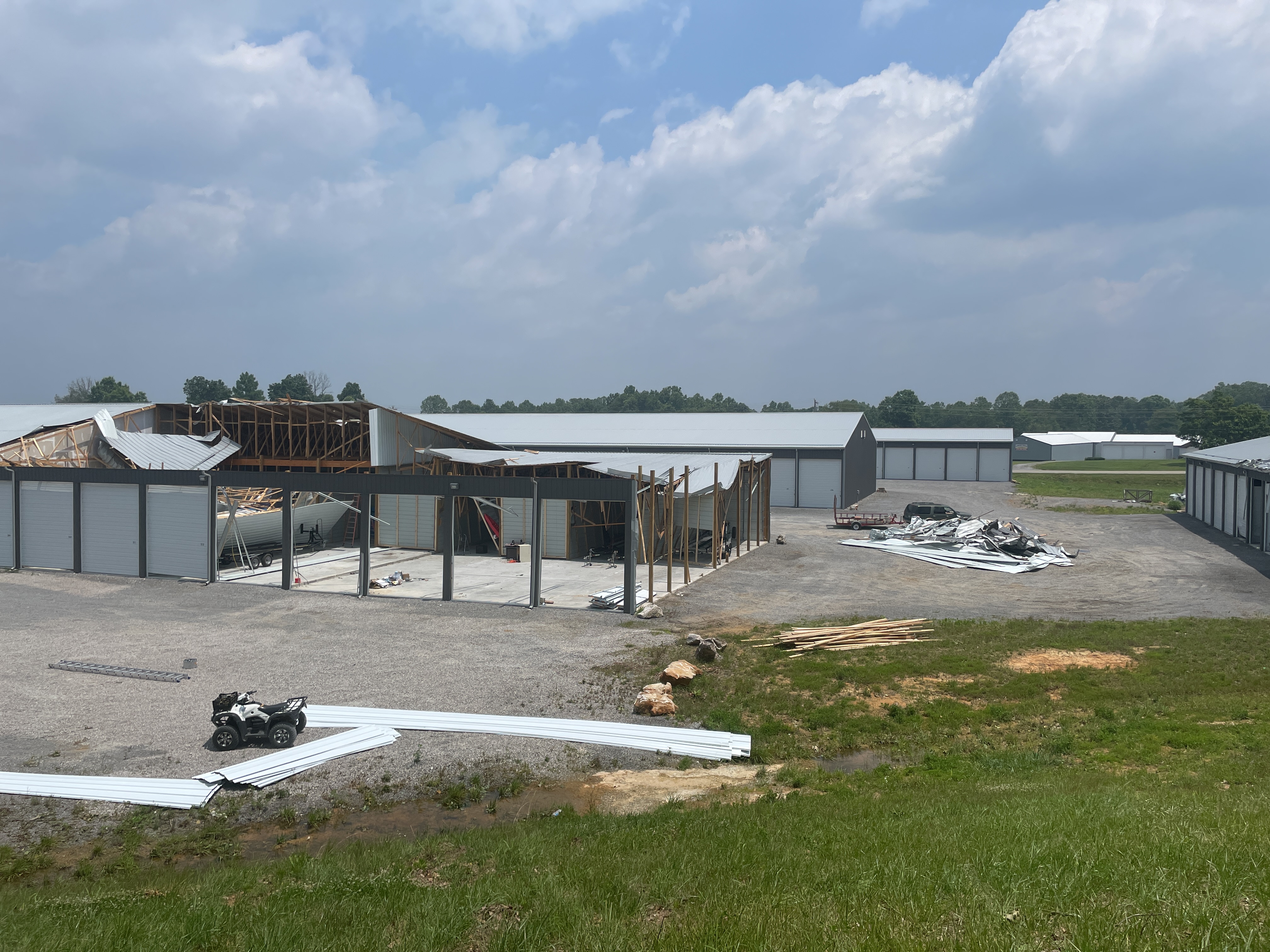
06/25/2023 Grayson KY Fire Dept/Rescue
Report per Clarkson Fire Chief, a 20x50 pole
barn has been destroyed by strong winds just
a mile north of Clarkson city limits.
Grayson County.
1126 PM Tstm Wnd Dmg Munfordville 37.28N 85.90W
06/25/2023 Hart KY Emergency Mngr
Numerous trees down across the roadways in
several areas including Priceville...
Linwood... Munfordville... and Hardyville.
Several power outages also being reported
across Hart County.
1145 PM Tstm Wnd Dmg 2 NE Stanford 37.56N 84.63W
06/25/2023 Lincoln KY Trained Spotter
Tree limbs and other debris across US 27
near Dix River Golf Course.
1153 PM Tstm Wnd Dmg Bryantsville 37.72N 84.65W
06/25/2023 Garrard KY Public
Tree down across the road.
1155 PM Tstm Wnd Dmg 5 ENE Gascon 37.01N 85.48W
06/25/2023 Adair KY Public
Alot of tree tops twisted off and uprooted
in this area, appears to be about a mile
long.
1155 PM Tstm Wnd Dmg Morgantown 37.22N 86.71W
06/25/2023 Butler KY Public
Report from mPING: Multiple trees damaged.
1155 PM Tstm Wnd Dmg Edmonton 36.98N 85.61W
06/25/2023 Metcalfe KY Emergency Mngr
Numerous trees down and power outage
currently approximately 5000 out of power.
Over 100 trees down throughout county.
Report came in at Midnight EDT, estimate at
least 5 minutes before for damage, and chose
Edmonton as location., but likely report for
the northern half of the county.
1210 AM Tstm Wnd Dmg 1 WNW Columbia 37.10N 85.32W
06/26/2023 Adair KY Law Enforcement
Corrects previous tstm wnd dmg report from 1
WNW Columbia. Reports of trees down across
roadway and one has fallen on a vehicle
causing damage.
1215 AM Tstm Wnd Dmg 1 NNW Glens Fork 37.03N 85.25W
06/26/2023 Adair KY Law Enforcement
Tree down South 55 blocking roadway.
1215 AM Tstm Wnd Dmg 3 SSE Rhoda 37.11N 86.22W
06/26/2023 Edmonson KY Public
Multiple trees down in neighborhood one
uprooted in our backyard. Time estimated
from radar.
1219 AM Tstm Wnd Dmg 3 ENE Freedom 36.93N 85.05W
06/26/2023 Russell KY Broadcast Media
Significant damage to boat storage building
at Jamestown Marina. Numerous trees and
power lines down.
1220 AM Tstm Wnd Dmg Glasgow 37.00N 85.92W
06/26/2023 Barren KY 911 Call Center
Numerous trees and power lines down across
Barren County.
1220 AM Tstm Wnd Dmg 3 SE Glasgow 36.98N 85.89W
06/26/2023 Barren KY Public
Large branches, 8 inches or more, down from
mature Silver Maple. Shingle damage to
neighbors roof. Several power lines down.
Time estimated from radar.
1224 AM Tstm Wnd Dmg 2 S Rhoda 37.13N 86.24W
06/26/2023 Edmonson KY Public
Significant damage to an RV garage relayed
on social media.
1225 AM Tstm Wnd Dmg 2 NE Coburg 37.22N 85.27W
06/26/2023 Adair KY Law Enforcement
Trees down Holmes Bend road near lake and
campground.
1229 AM Tstm Wnd Dmg 2 NE Haywood 36.97N 85.94W
06/26/2023 Barren KY Public
Entire roof of a Shell gas station flipped
over off of Hwy 90.
1235 AM Tstm Wnd Dmg Plum Springs 37.02N 86.38W
06/26/2023 Warren KY Public
Trees down, large branches down. Time
estimated from radar.
1247 AM Tstm Wnd Dmg Burkesville 36.79N 85.37W
06/26/2023 Cumberland KY 911 Call Center
Trees were blown down across Cumberland
County, resulting in several road closures.
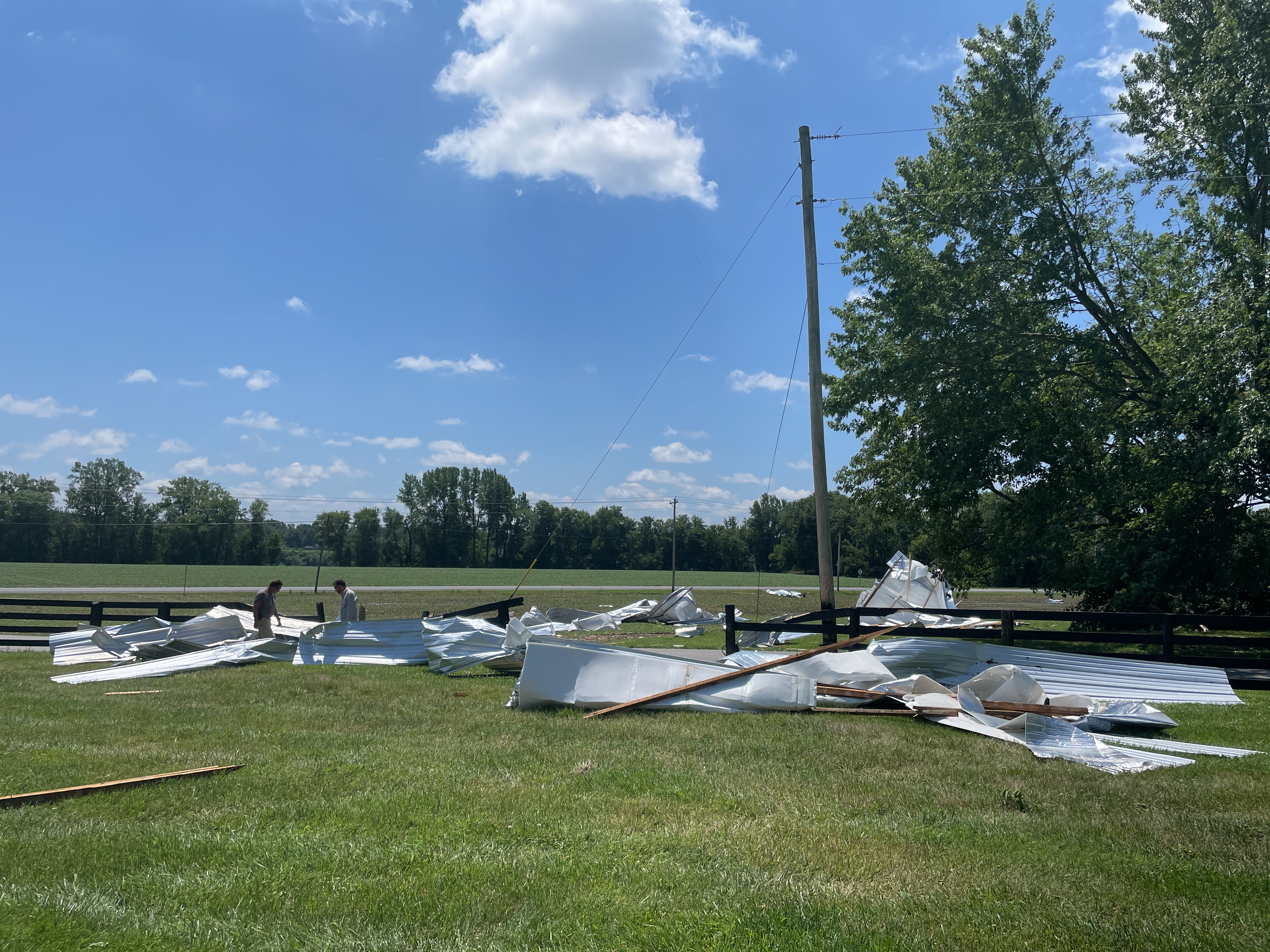
1253 AM Tstm Wnd Dmg 3 SSE Rockbridge 36.74N 85.64W
06/26/2023 Monroe KY Public
Pictures show metal siding and roofing blown
off a barn, as well as several trees down
along Meshack Creek Road and Lyons Chapel
Road.
0100 AM Tstm Wnd Dmg Albany 36.69N 85.14W
06/26/2023 Clinton KY 911 Call Center
Numerous reports of tree and power line
damage across Clinton County.
0911 PM Tstm Wnd Gst 1 SSE Highview 38.12N 85.62W
06/25/2023 E70 MPH Jefferson KY NWS Employee
1 inch hail as well.
1052 PM Tstm Wnd Gst 1 NNW Richmond 37.75N 84.30W
06/25/2023 E70 MPH Madison KY Public
1100 PM Tstm Wnd Gst 1 SSW Waco 37.72N 84.15W
06/25/2023 M66 MPH Madison KY Mesonet
Kentucky Mesonet station ELST Richmond 8 E.
1154 PM Tstm Wnd Gst Bryantsville 37.72N 84.65W
06/25/2023 E65 MPH Garrard KY Public
1220 AM Tstm Wnd Gst 1 SW Woodbury 37.18N 86.65W
06/26/2023 M60 MPH Butler KY Mesonet
Kentucky Mesonet station WDBY Morgantown 4
SSE.
1235 AM Tstm Wnd Gst 2 NE Plum Springs 37.04N 86.35W
06/26/2023 M63 MPH Warren KY Mesonet
Kentucky Mesonet site EWPK measured a 63 mph
wind gust.
Rain Reports
-RainfallAnalysis-20230624_1200-20230626_1200.png)
Environment
 |
 |
 |
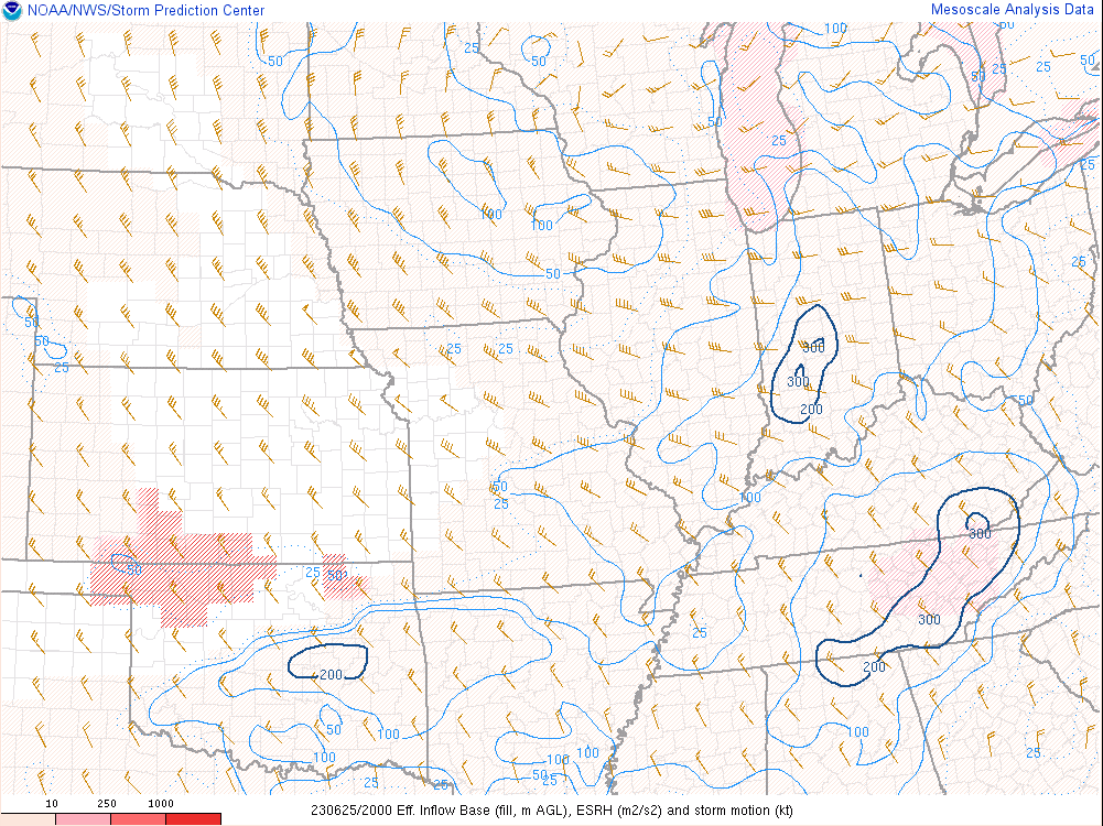 |
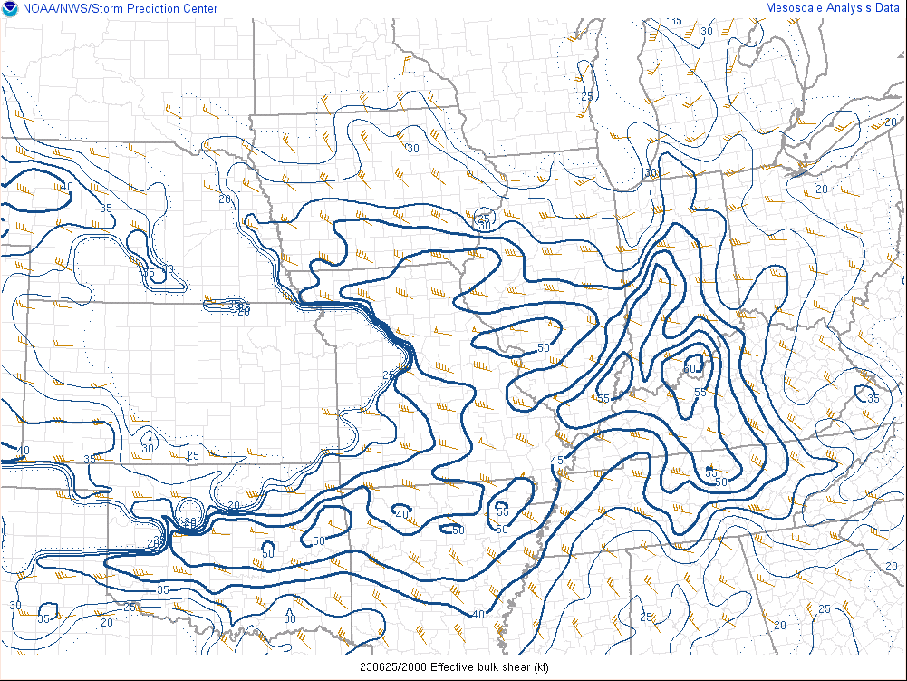
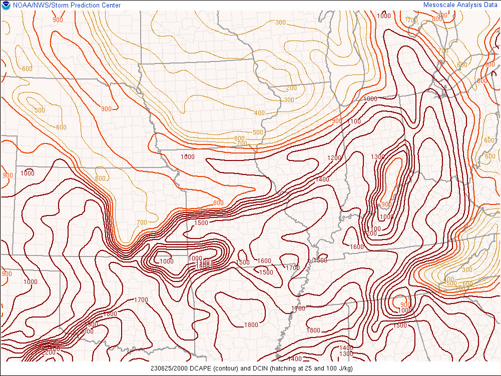
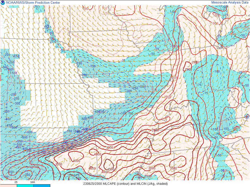
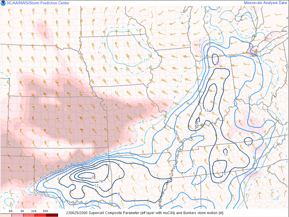
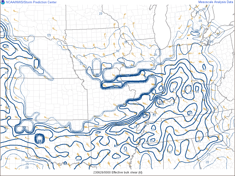
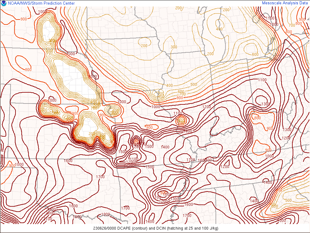
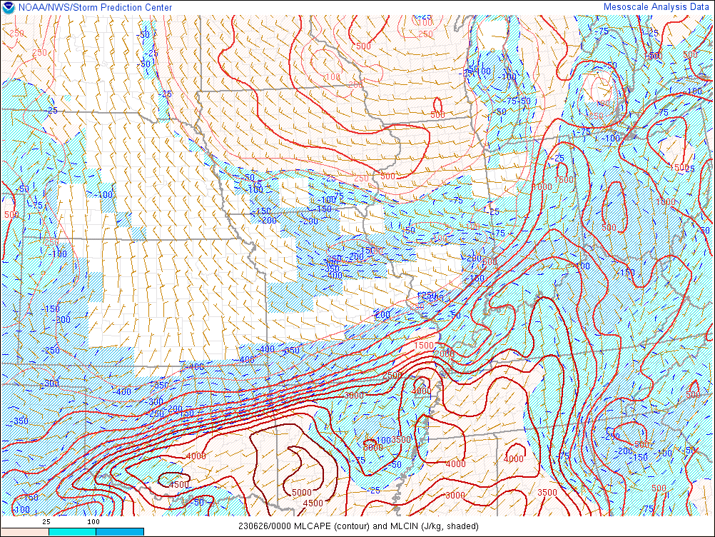
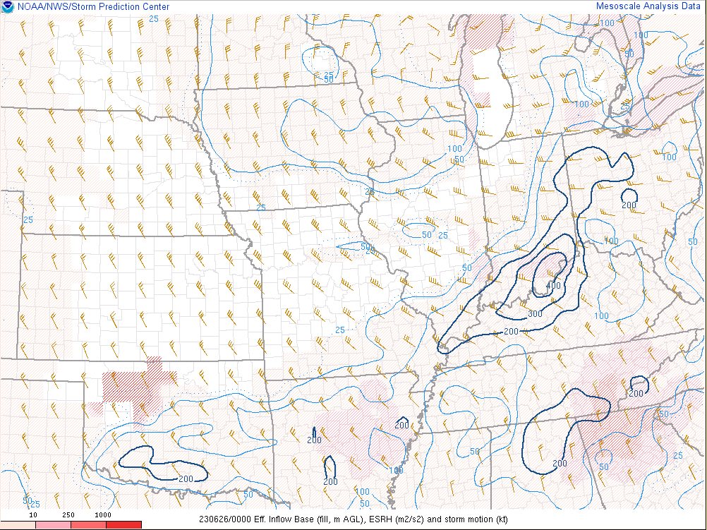
| Figure 1: Effective Bulk Shear | Figure 2: DCAPE | Figure 3: Mixed Layer CAPE | Figure 4: Effective SRH |
 |
 |
||
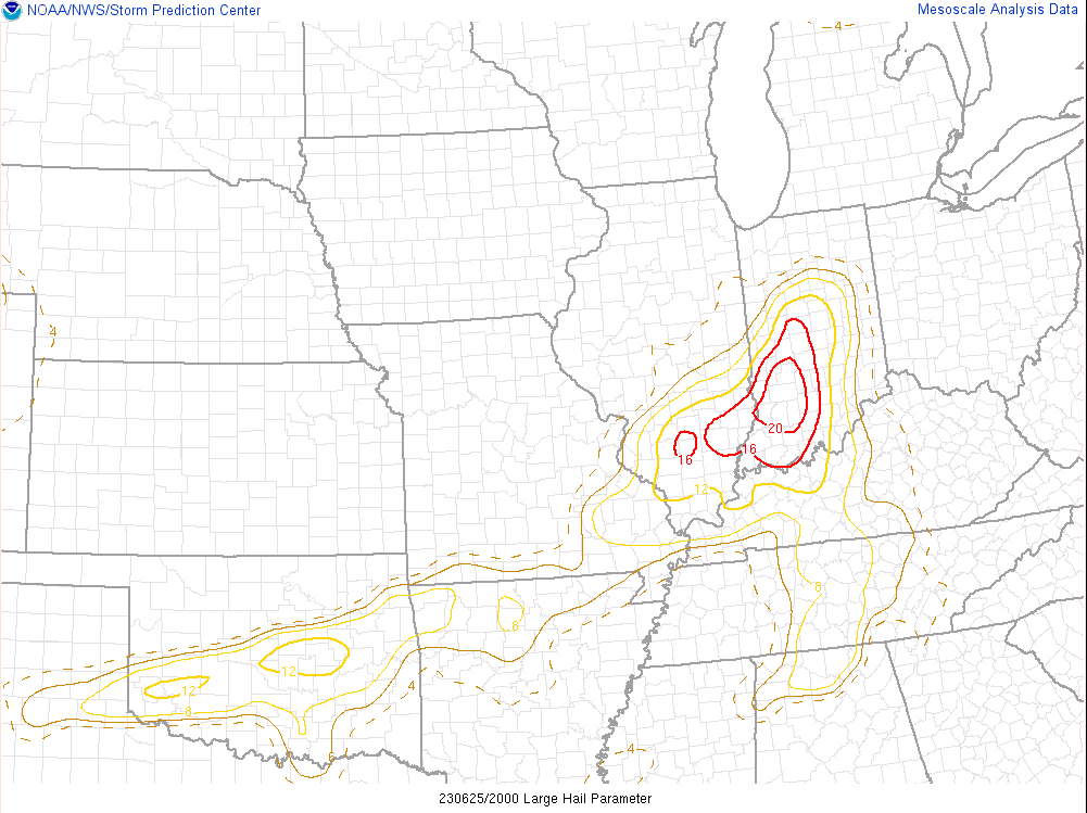
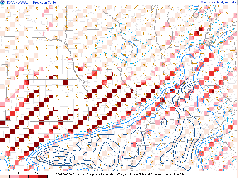
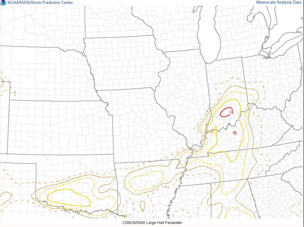
| Figure 5: Supercell Composite Parameter | Figure 6: Large Hail Parameter |
 |
 |
 |
 |
| Figure 7: Effective Bulk Shear | Figure 8: DCAPE | Figure 9: Mixed Layer CAPE | Figure 10: Effective SRH |
 |
 |
||
| Figure 11: Supercell Composite Parameter | Figure 12: Large Hail Parameter |
 |
Media use of NWS Web News Stories is encouraged! Please acknowledge the NWS as the source of any news information accessed from this site. |
|


.jpg)


 Weather Story
 Weather Map
 Local Radar