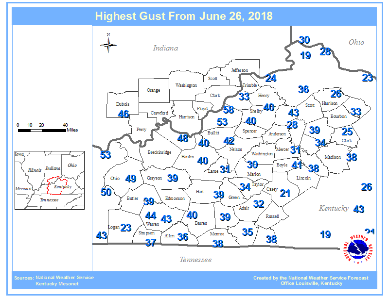
Overview
|
Multiple rounds of storms affected the region through the day. Training storms across southeast central KY in the morning resulted in significant flash flooding. Strong to severe thunderstorms then developed during the late morning across east central KY. As these storms moved off to the east another round of storms moved in from the west. These storms resulted in many reports of wind damage as well as some additional flooding and flash flooding.
|
Image credit: Tom Williams |
 |
 |
 |
|
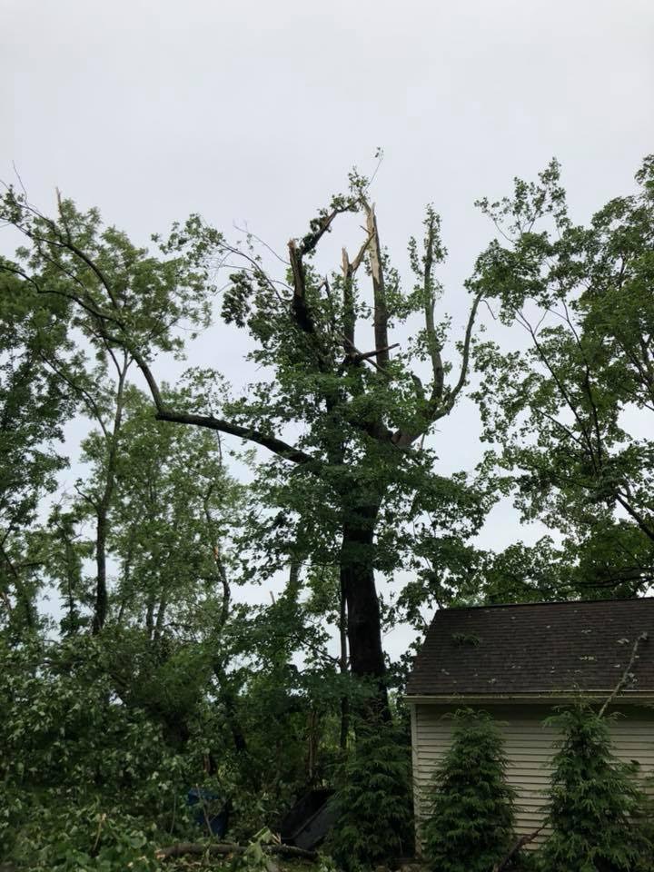
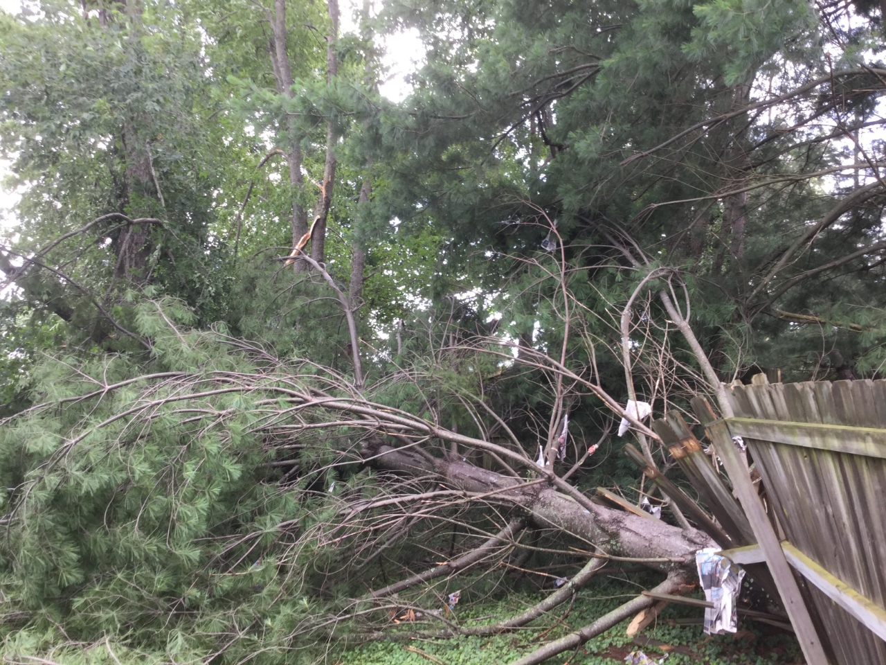
Tree damage in Crestwood, KY Image credit: Teresa Michels |
Tree damage in Brownsville, KY Image credit: Erin Gary |
Tree damage in Louisville, KY Image credit: Ron Steve |
Tornado:
|
Tornado - Louisville, KY
Track Map 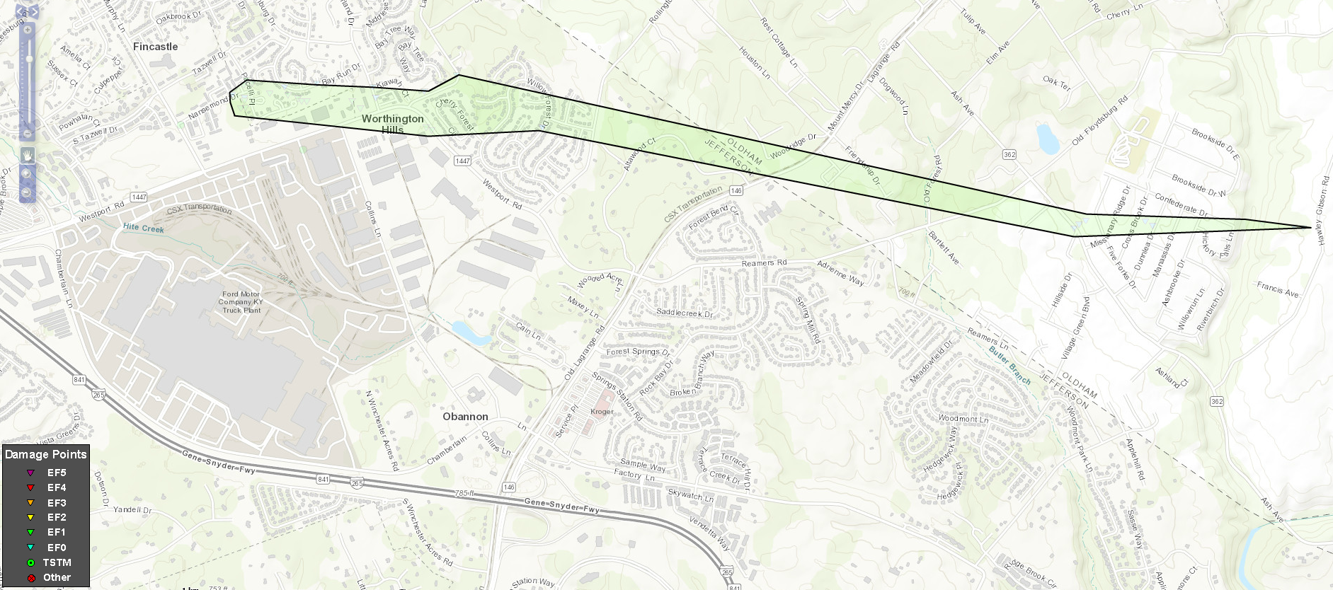 
Downloadable KMZ File |
||||||||||||||||||||||||
The Enhanced Fujita (EF) Scale classifies tornadoes into the following categories:
| EF0 Weak 65-85 mph |
EF1 Moderate 86-110 mph |
EF2 Significant 111-135 mph |
EF3 Severe 136-165 mph |
EF4 Extreme 166-200 mph |
EF5 Catastrophic 200+ mph |
 |
|||||
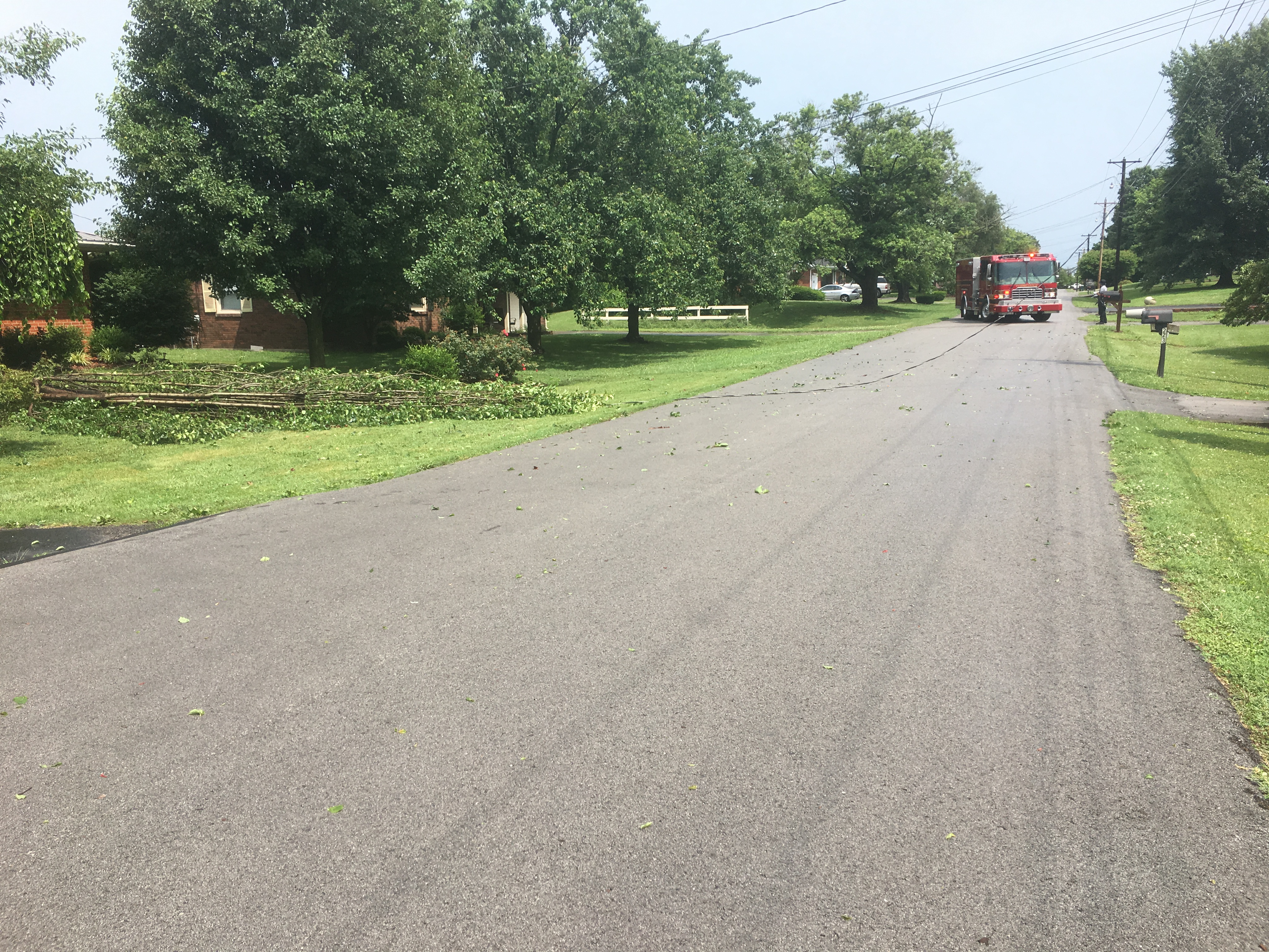
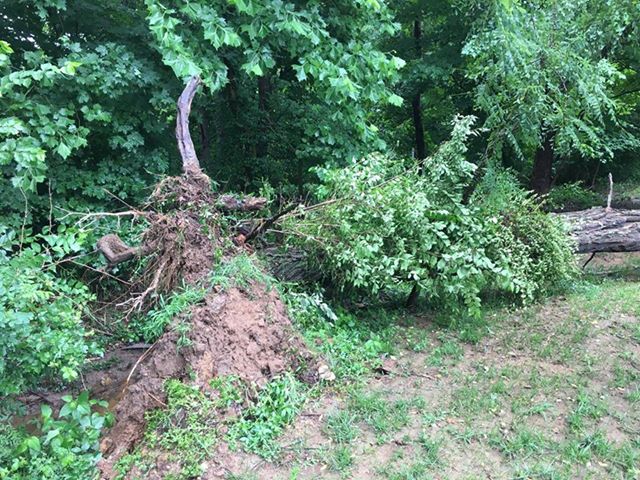
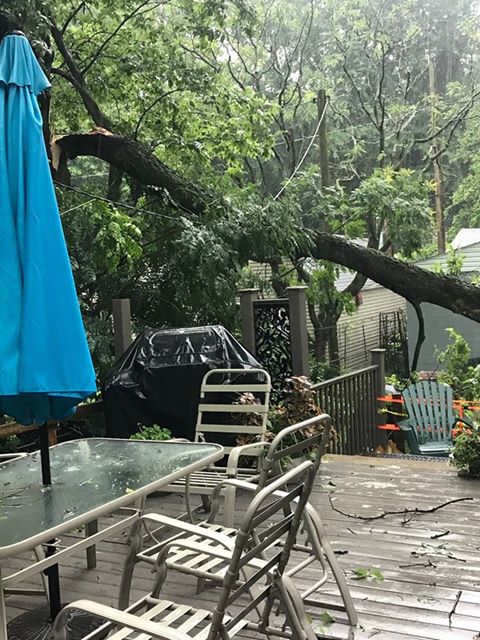
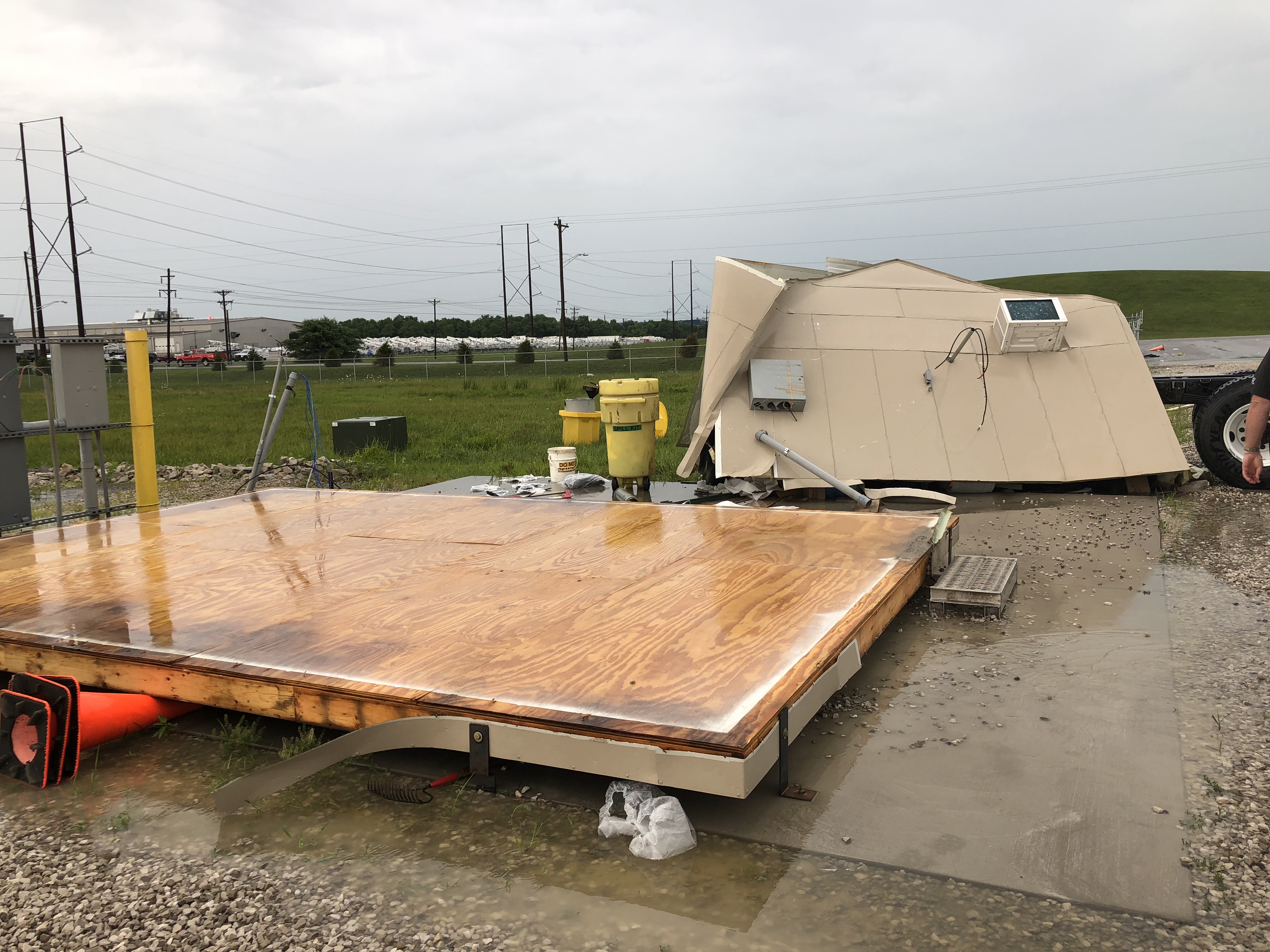
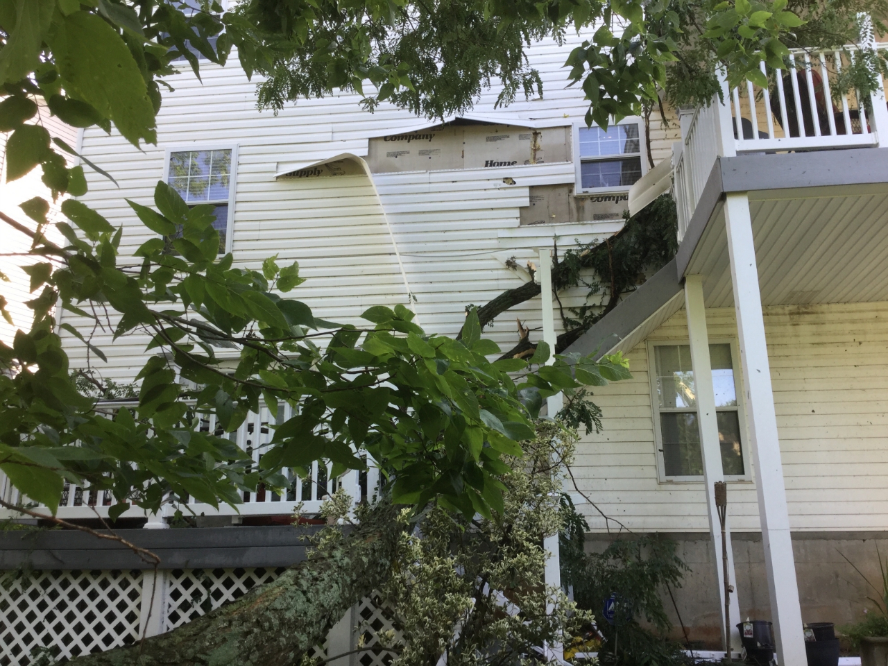
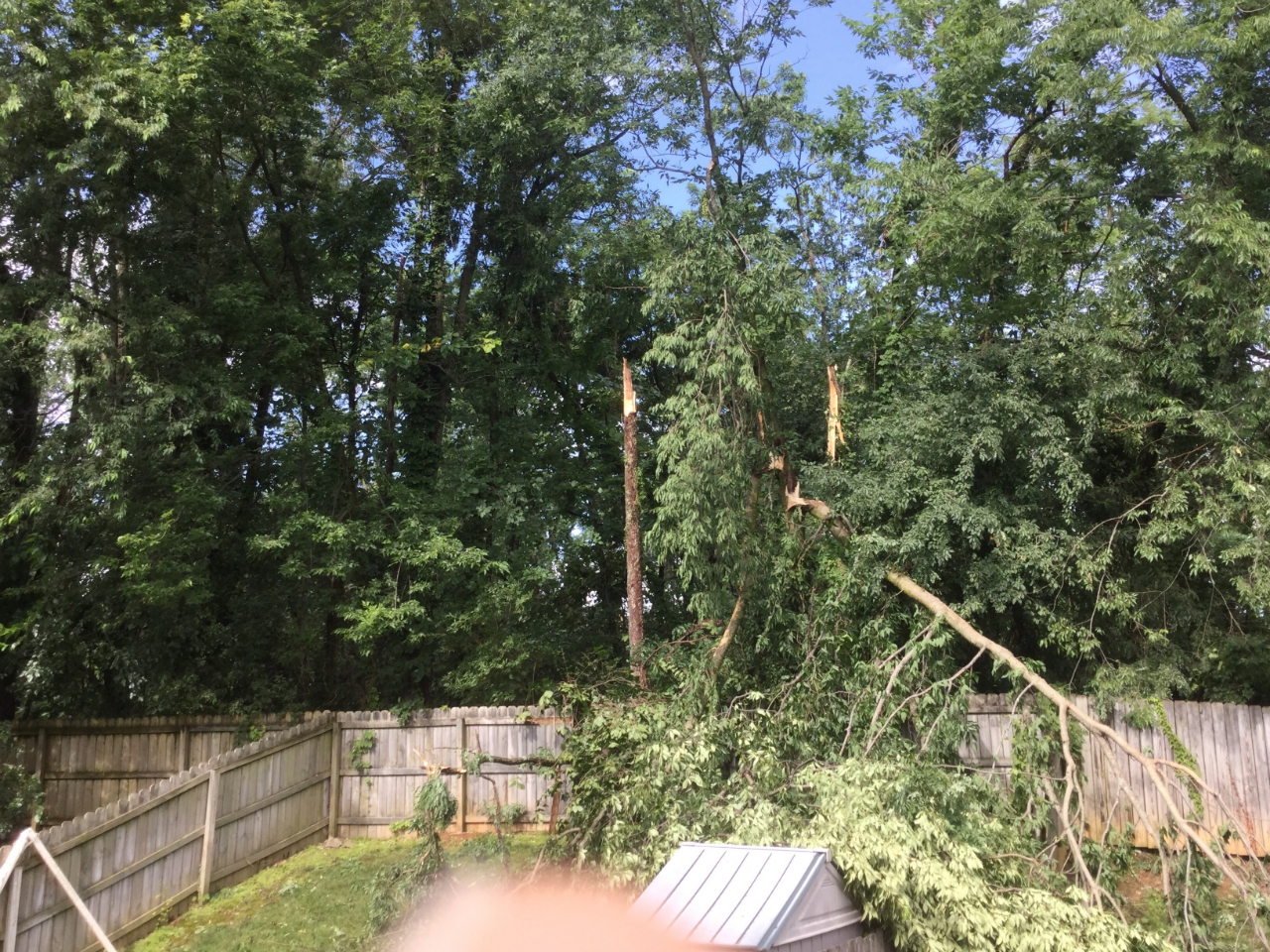
Wind:
Many reports of wind damage were received across the region from both from individual cells and from bowing lines crossing the area. Gusts as high as 58 mph were recorded across southern IN and central KY.
Wind
 |
 |
 |
 |
|
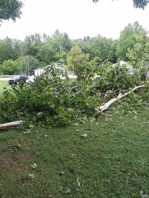
Tree and power line down in Campbellsville, KY Image credit: Ronnie Dooley |
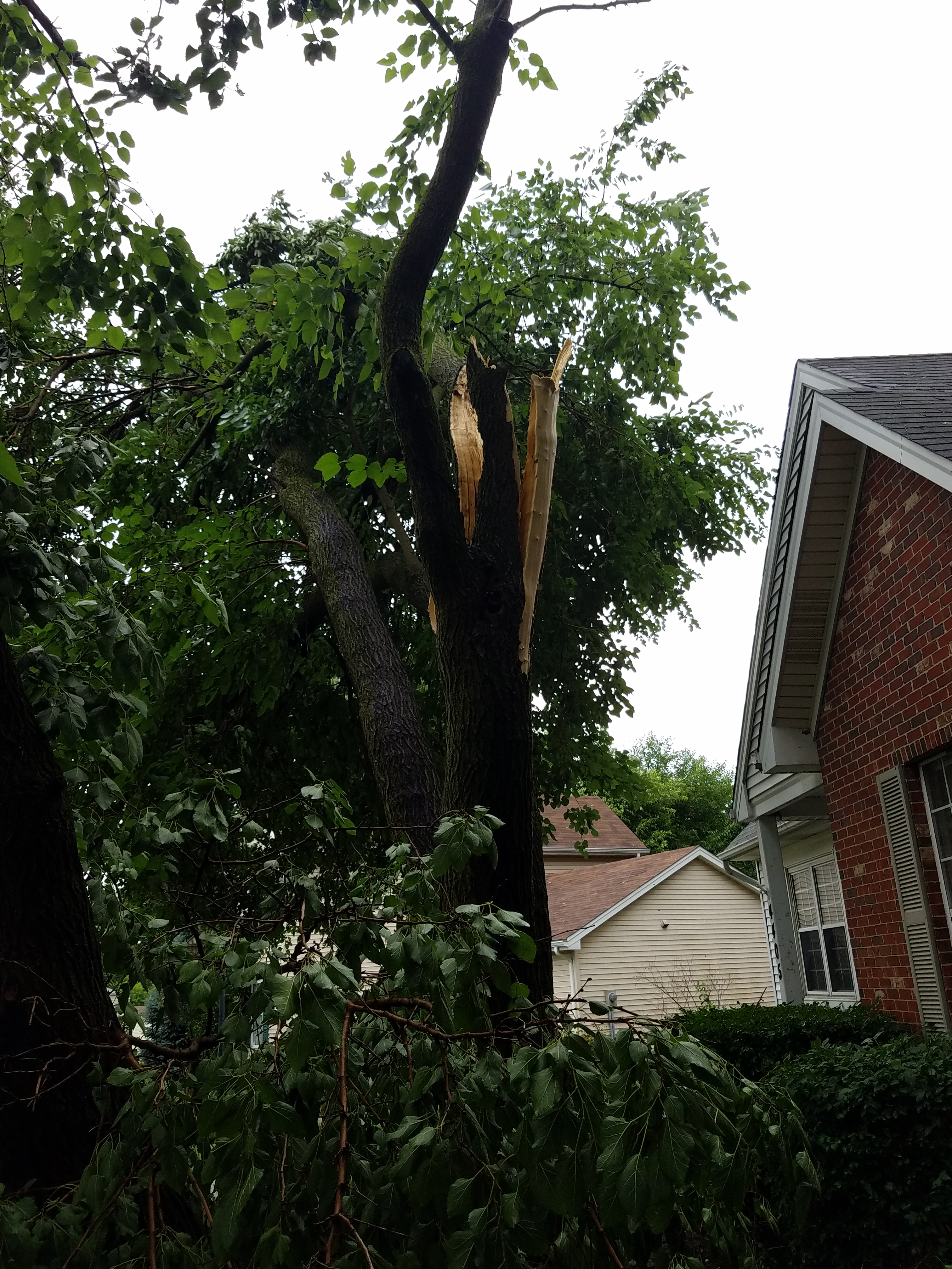
Large tree down in Crestwood, KY Image credit: Marc Bittner |
Tree down in Louisville, KY Image credit: Tyler Martin |
Debris scattered from a damaged outbuilding in Elizabethtown, KY Image credit: Tom Williams |
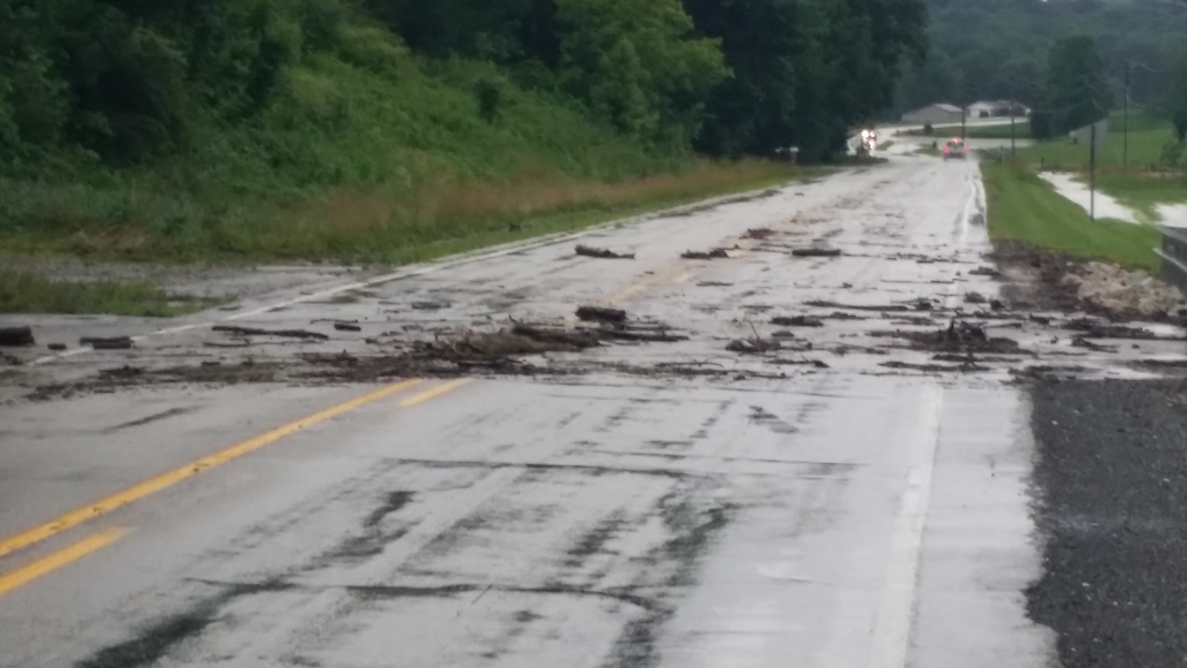
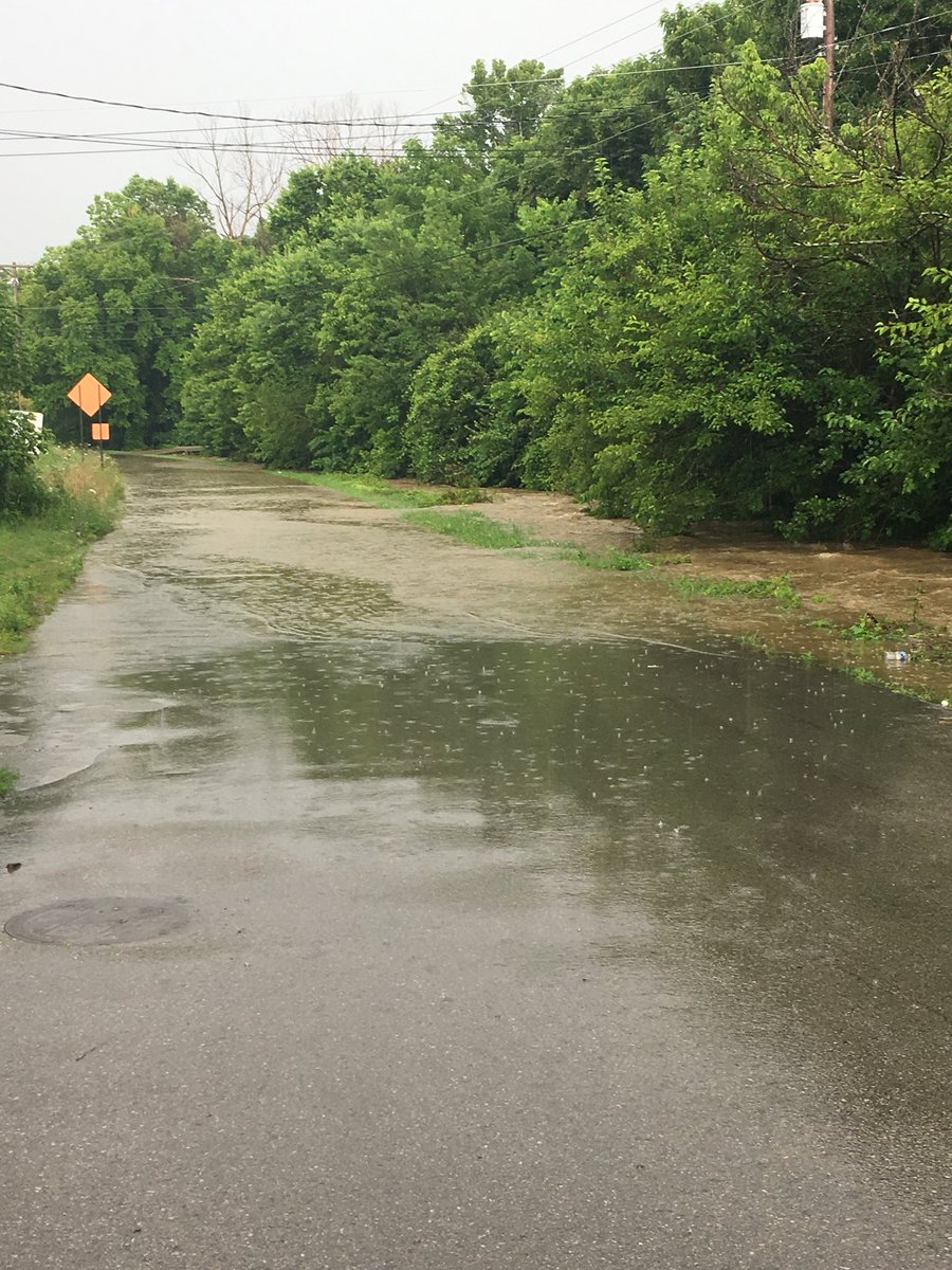
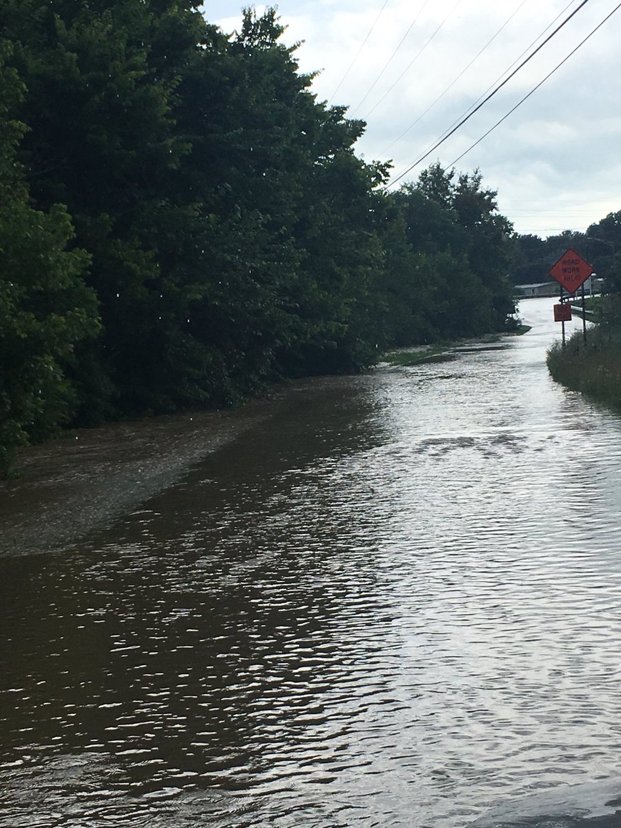
Flooding
Many areas had already received multiple round of rain over the preceding days. With the saturated grounds and intense rainfall rates, multiple instances of flooding were recorded across the region.
Photos
 |
 |
 |
|
Debris from flooding in Dubois County, IN Image credit:Gary Fritz |
Flooding in Richmond, KY Image credit: Jason |
Flooding in Richmond, KY Image credit: Jason |
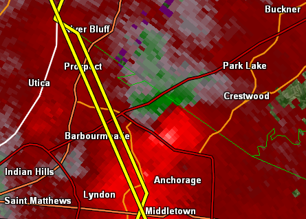
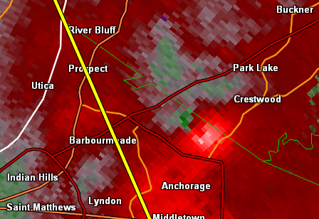
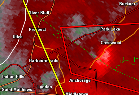
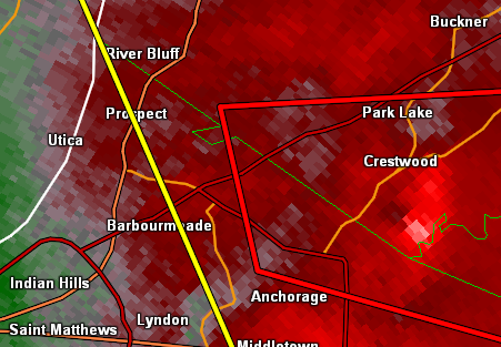
Radar:
Louisville Tornado
 |
 |
 |
 |
| 1:42pm EDT Storm Relative Velocity |
1:44pm EDT Storm Relative Velocity |
1:46pm EDT Storm Relative Velocity |
1:48pm EDT Storm Relative Velocity |
Storm Reports
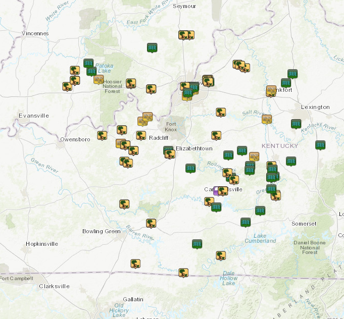
PRELIMINARY LOCAL STORM REPORT...SUMMARY
NATIONAL WEATHER SERVICE LOUISVILLE KY
937 AM EDT WED JUN 27 2018
..TIME... ...EVENT... ...CITY LOCATION... ...LAT.LON...
..DATE... ....MAG.... ..COUNTY LOCATION..ST.. ...SOURCE....
..REMARKS..
0435 PM FLOOD 2 NNW RUSSELL SPRINGS 37.08N 85.10W
06/26/2018 RUSSELL KY 911 CALL CENTER
WATER OVER OLD SANO ROAD IN RUSSELL COUNTY,
BUT ROADWAY IS STILL PASSABLE. TIME EARLIER
IN DAY.
0133 PM TSTM WND GST 2 SW SAINT MATTHEWS 38.22N 85.67W
06/26/2018 M58 MPH JEFFERSON KY ASOS
REPORTED AT BOWMAN FIELD LOUISVILLE KY.
0432 PM FLOOD 3 SSE PHIL 37.18N 84.94W
06/26/2018 CASEY KY 911 CALL CENTER
HIGH WATER ON HIGHWAY 910 IN CASEY COUNTY,
BUT STILL PASSABLE. TIME EARLIER IN DAY.
0428 PM FLOOD 5 SE GREENSBURG 37.21N 85.42W
06/26/2018 GREEN KY 911 CALL CENTER
WATER OVER ROADWAY REPORTED AT EBENEZER RD
GREEN COUNTY, KY. TIME EARLIER IN DAY.
0405 PM FLASH FLOOD 2 ENE STAMPING GROUND 38.28N 84.66W
06/26/2018 SCOTT KY EMERGENCY MNGR
A CAR WAS REPORTED TO BE TRAPPED IN HIGH
WATER ON SEBREE ROAD AT DUVALL STATION NEAR
STAMPING GROUND.
0400 PM FLOOD 2 WSW LANCASTER 37.61N 84.61W
06/26/2018 GARRARD KY 911 CALL CENTER
A LITTLE WATER OVER OLD DANVILLE ROAD.
0345 PM FLOOD 4 SW SADIEVILLE 38.36N 84.59W
06/26/2018 SCOTT KY 911 CALL CENTER
FLOODING REPORTED AT BURTON PIKE SCOTT
COUNTY, KY. TIME EARLIER IN DAY.
0342 PM FLOOD 2 N BUFFALO 37.55N 85.70W
06/26/2018 LARUE KY EMERGENCY MNGR
WATER FLOODING OVER LOW-WATER CROSSINGS
REPORTED AT LARUE COUNTY. TIME EARLIER IN
DAY.
0341 PM TSTM WND DMG 2 WSW PEWEE VALLEY 38.30N 85.52W
06/26/2018 JEFFERSON KY EMERGENCY MNGR
STRUCTURAL DAMAGE REPORTED AT WESTPORT ROAD
LOUISVILLE, KY. TIME EARLIER IN DAY.
0340 PM TSTM WND DMG LOUISVILLE 38.25N 85.76W
06/26/2018 JEFFERSON KY EMERGENCY MNGR
POWER DOWN FROM TREES IN MANY PARTS OF
LOUISVILLE. TIME EARLIER IN DAY.
0339 PM FLOOD 4 SSE LOUISVILLE 38.20N 85.73W
06/26/2018 JEFFERSON KY EMERGENCY MNGR
WATER FLOODING OVER ROAD REPORTED AT 3200
PRESTON HIGHWAY LOUISVILLE, KY. TIME EARLIER
IN DAY.
0338 PM FLOOD 2 W SAINT MATTHEWS 38.24N 85.67W
06/26/2018 JEFFERSON KY EMERGENCY MNGR
WATER FLOODING OVER ROADS REPORTED AT SENECA
PARK LOUISVILLE, KY. TIME EARLIER IN DAY.
0337 PM FLOOD 3 WSW SAINT MATTHEWS 38.24N 85.70W
06/26/2018 JEFFERSON KY EMERGENCY MNGR
WATER FLOODING OVER ROADS REPORTED AT
CHEROKEE PARK LOUISVILLE, KY. TIME EARLIER
IN DAY.
0332 PM FLOOD 1 W SAINT MATTHEWS 38.25N 85.66W
06/26/2018 JEFFERSON KY EMERGENCY MNGR
WATER FLOODING OVER ROAD REPORTED AT 3700
LEXINGTON RD LOUISVILLE, KY. TIME EARLIER IN
DAY.
0330 PM TSTM WND DMG 2 WSW PEWEE VALLEY 38.30N 85.52W
06/26/2018 JEFFERSON KY PUBLIC
MANY TREES (SEVERAL SNAPPED OFF 1/2 TO 3/4
OF THE WAY UP) AND LIMBS DOWN. SEVERAL TREES
HAVE FALLEN ON TOP OF POWER LINES.
0327 PM FLASH FLOOD 1 N MIDDLEBURG 37.37N 84.82W
06/26/2018 CASEY KY 911 CALL CENTER
STATE ROAD 198 HAS BEEN CLOSED DUE TO
FLOODING OVER THE ROADWAY.
0314 PM TSTM WND DMG 4 SE MIDDLEBURG 37.31N 84.77W
06/26/2018 CASEY KY 911 CALL CENTER
TREE REPORTED DOWN ON HURRICANE RIDGE ROAD.
0314 PM TSTM WND DMG 3 SE MIDDLEBURG 37.32N 84.78W
06/26/2018 CASEY KY 911 CALL CENTER
TREE REPORTED DOWN ON BASTIN CREEK ROAD.
0307 PM TSTM WND DMG 1 ENE CECILIA 37.67N 85.93W
06/26/2018 HARDIN KY PUBLIC
SMALL BUILDING BLOWN OFF FOUNDATION WITH
DEBRIS BLOWN APPROXIMATELY 800 FEET
DOWNWIND.
0300 PM TSTM WND GST 4 NNE NICHOLASVILLE 37.93N 84.55W
06/26/2018 E55 MPH JESSAMINE KY PUBLIC
IN SOUTHERN JESSAMINE COUNTY, A LOT OF
LIGHTNING AND STRONG WIND GUSTS UP TO 55MPH.
TIME ESTIMATED USING RADAR.
0300 PM FLOOD 4 NNE NICHOLASVILLE 37.93N 84.55W
06/26/2018 JESSAMINE KY PUBLIC
FLOODING ON US27 IN SOUTHERN JESSAMINE
COUNTY.
0252 PM TSTM WND DMG 1 E GAMALIEL 36.64N 85.78W
06/26/2018 MONROE KY 911 CALL CENTER
TREES DOWN.
0247 PM TSTM WND GST FORKS OF ELKHORN 38.22N 84.82W
06/26/2018 M53 MPH FRANKLIN KY MESONET
MESONET STATION D5536, FORKS OF ELKHORN.
0242 PM TSTM WND DMG BURKESVILLE 36.79N 85.37W
06/26/2018 CUMBERLAND KY EMERGENCY MNGR
TREES REPORTED DOWN.
0240 PM TSTM WND DMG HUSTONVILLE 37.47N 84.82W
06/26/2018 LINCOLN KY 911 CALL CENTER
SEVERAL TREES DOWN IN HUSTONVILLE.
0236 PM TSTM WND GST 4 N SALVISA 37.97N 84.87W
06/26/2018 M58 MPH ANDERSON KY TRAINED SPOTTER
58 MPH RECORDED ON BLUEGRASS PKWY WITH
CALIBRATED EQUIPMENT.
0230 PM TSTM WND GST 3 W PERRYVILLE 37.65N 85.01W
06/26/2018 E50 MPH BOYLE KY PUBLIC
EXTREMELY HEAVY RAIN, TREE BRANCHES DOWN,
ESTIMATED 50MPH.
0220 PM TSTM WND DMG 6 NNW MANNSVILLE 37.45N 85.23W
06/26/2018 MARION KY 911 CALL CENTER
TREE DOWN ON FISHER CREEK ROAD.
0216 PM TSTM WND DMG 2 NE NEW MARKET 37.51N 85.30W
06/26/2018 MARION KY 911 CALL CENTER
TREE DOWN ON EAST LOVERS LANE NEAR US 68.
0215 PM FLASH FLOOD 2 N BEAUMONT 36.89N 85.63W
06/26/2018 METCALFE KY TRAINED SPOTTER
WATER FLOWING ACROSS LONE STAR CHURCH RD.
0215 PM TSTM WND DMG 2 WNW BETHLEHEM 38.41N 85.11W
06/26/2018 HENRY KY LAW ENFORCEMENT
MULTIPLE TREES REPORTED DOWN AT POINT
PLEASANT RD NEW CASTLE, KY.
0210 PM TSTM WND DMG NEW CASTLE 38.43N 85.16W
06/26/2018 HENRY KY LAW ENFORCEMENT
MULTIPLE TREES REPORTED DOWN AT EAST CROSS
MAIN ST NEW CASTLE, KY.
0210 PM TSTM WND DMG 1 W NEW CASTLE 38.44N 85.19W
06/26/2018 HENRY KY LAW ENFORCEMENT
MULTIPLE TREES REPORTED DOWN AT LAGRANGE RD
NEW CASTLE, KY.
0203 PM TSTM WND DMG GREENSBURG 37.26N 85.50W
06/26/2018 GREEN KY EMERGENCY MNGR
MULTIPLE TREES DOWN COUNTYWIDE, SOME
BLOCKING ROADS. ALSO, SOME SIDE ROADS ARE
COVERED WITH WATER AS SOME SMALL
CREEKS/STREAMS HAVE OVERFLOWN.
0156 PM TSTM WND DMG 1 WSW TAYLORSVILLE 38.03N 85.37W
06/26/2018 SPENCER KY NWS EMPLOYEE
1 TREE HAD TO BE REMOVED FROM OAK TREE WAY,
AND 1 TREE HAD TO BE REMOVED FROM ELK CREEK
ROAD.
0150 PM TSTM WND DMG 5 ESE MT. ARIEAL 36.72N 86.30W
06/26/2018 ALLEN KY 911 CALL CENTER
TREES REPORTED DOWN AT FRANKLIN RD AND
CHAPEL HILL RD SCOTTSVILLE, KY.
0148 PM FLOOD 2 SSW PEWEE VALLEY 38.29N 85.50W
06/26/2018 JEFFERSON KY PUBLIC
BACKYARDS AND STREETS ARE FLOODED.
0148 PM TSTM WND DMG 2 SW PEWEE VALLEY 38.29N 85.51W
06/26/2018 JEFFERSON KY PUBLIC
TRESS DOWN ACROSS RAILROAD.
0145 PM FLOOD 2 SSW SALEM 38.58N 86.12W
06/26/2018 WASHINGTON IN NWS EMPLOYEE
CORRECTS PREVIOUS FLASH FLOOD REPORT FROM 2
SSW SALEM. BECKS MILL ROAD FLOODING.
0142 PM TSTM WND DMG 2 SW PEWEE VALLEY 38.29N 85.51W
06/26/2018 JEFFERSON KY PUBLIC
TREES DOWN OVER RAILROAD TRACKS.
0142 PM TSTM WND DMG 2 WSW PEWEE VALLEY 38.31N 85.52W
06/26/2018 JEFFERSON KY PUBLIC
TREE DOWN ON ROOF; MUCH SIDING REMOVED FROM
AT LEAST TWO HOMES.
0142 PM TSTM WND DMG 1 WSW PEWEE VALLEY 38.31N 85.51W
06/26/2018 JEFFERSON KY NWS EMPLOYEE
LARGE LIMBS DOWN ALONG ROLLINGTON RD IN
JEFFERSON COUNTY AND INTO OLDHAM COUNTY,
PICNIC TABLE IN MIDDLE OF MAIN ROAD.
0136 PM FLOOD 2 N CECILIA 37.70N 85.94W
06/26/2018 HARDIN KY PUBLIC
SOME FLOODING ON SAINT JOHNS ROAD IN
ELIZABETHTOWN ALONG WITH TREE BRANCHES
SCATTERED ACROSS THE ROAD.
0136 PM TSTM WND DMG 2 E CECILIA 37.67N 85.92W
06/26/2018 HARDIN KY PUBLIC
PRIVATE BUSINESS AGC AUTOMOTIVE AMERICAS HAD
MECHANICAL UNITS BLOWN OFF ROOF AND METAL
WALL PANELS BLOWN APPROXIMATELY 1000-1500 FT
DOWNWIND.
0135 PM TSTM WND GST 4 NW OKOLONA 38.17N 85.74W
06/26/2018 E53 MPH JEFFERSON KY ASOS
REPORTED AT STANDIFORD FIELD LOUISVILLE KY.
0130 PM TSTM WND DMG 3 W SAINT MATTHEWS 38.25N 85.69W
06/26/2018 JEFFERSON KY PUBLIC
LARGE TREE FELL ON POWER LINE NEAR
RESIDENCE.
0130 PM TSTM WND DMG 3 W SAINT MATTHEWS 38.25N 85.69W
06/26/2018 JEFFERSON KY BROADCAST MEDIA
TREE DOWN ON A CAR AT A RESIDENCE ON
GRINSTEAD IN LOUISVILLE.
0120 PM TSTM WND DMG 3 N HAYS 37.07N 86.13W
06/26/2018 EDMONSON KY 911 CALL CENTER
CORRECTS TIME FROM PREVIOUS TSTM WND DMG
REPORT FROM 3 N HAYS. SEVERAL TREES DOWN.
0110 PM FLASH FLOOD SCOTTSBURG 38.69N 85.78W
06/26/2018 SCOTT IN EMERGENCY MNGR
MAIN INTERSECTIONS FLOODED IN SCOTTSBURG.
0105 PM TSTM WND DMG 1 NNW CORYDON 38.23N 86.13W
06/26/2018 HARRISON IN NWS EMPLOYEE
BRADFORD PEAR TYPE TREE BROKE IN HALF WITH
UPPER HALF BLOCKING SOUTHBOUND EDSEL LANE AT
FEDERAL DRIVE.
0105 PM TSTM WND DMG 2 NNW CORYDON 38.23N 86.13W
06/26/2018 HARRISON IN NWS EMPLOYEE
LARGE BRADFORD PEAR TYPE TREE BROKE IN HALF
ON THE NORTHERN SIDE OF THE HOLIDAY INN
EXPRESS NEAR CONCORD AVENUE AND FEDERAL
DRIVE.
0105 PM TSTM WND DMG 1 NNW CORYDON 38.23N 86.13W
06/26/2018 HARRISON IN NWS EMPLOYEE
LARGE BRADFORD PEAR TYPE TREE HAD LARGE LIMB
BROKE OFF AND IN THE PARKING LOT AT CULVER`S
ON THE NORTH SIDE OF THE FEDERAL DRIVE AND
EDSEL LANE.
0103 PM TSTM WND DMG 4 NNW HUDSON 37.70N 86.32W
06/26/2018 BRECKINRIDGE KY 911 CALL CENTER
CORRECTS PREVIOUS TSTM WND DMG REPORT FROM 4
NNW HUDSON. TREE DOWN ON POWER LINES ON
STATE ROAD 1073.
0103 PM TSTM WND DMG 2 E ROUNDHILL 37.24N 86.42W
06/26/2018 EDMONSON KY 911 CALL CENTER
CORRECTS TIME FROM PREVIOUS TSTM WND DMG
REPORT FROM 2 E ROUNDHILL. SEVERAL TREES
DOWN.
0101 PM TSTM WND DMG 4 SSW GUSTON 37.83N 86.24W
06/26/2018 BRECKINRIDGE KY 911 CALL CENTER
TREE DOWN ON S STATE ROAD 333.
0100 PM TSTM WND DMG 3 S NEW FRANKFORT 38.69N 85.71W
06/26/2018 SCOTT IN BROADCAST MEDIA
TREES DOWN ALONG HIGHWAY 56.
0100 PM TSTM WND GST 2 WNW EKRON 37.95N 86.22W
06/26/2018 M48 MPH MEADE KY MESONET
MESONET STATION BRND, 2 WNW EKRON.
0100 PM TSTM WND DMG SCOTTSBURG 38.69N 85.78W
06/26/2018 SCOTT IN EMERGENCY MNGR
TWO TREES DOWN ON HOMES IN SCOTTSBURG, IN.
1259 PM TSTM WND DMG HARNED 37.75N 86.41W
06/26/2018 BRECKINRIDGE KY 911 CALL CENTER
A TREE FELL ON THE CORNER OF A HOUSE IN
HARNED.
1255 PM TSTM WND GST 1 SE BRANDENBURG 37.99N 86.17W
06/26/2018 M56 MPH MEADE KY TRAINED SPOTTER
REPORTED AT 355 MAPLE ROAD BRANDENBURG KY.
1254 PM TSTM WND DMG 1 E HARNED 37.75N 86.41W
06/26/2018 BRECKINRIDGE KY EMERGENCY MNGR
BUILDING UNDER CONSTRUCTION (JUST THE FRAME)
WAS FLATTENED. TREES WERE ALSO REPORTED DOWN
IN THE CENTRAL/NORTHERN PART OF THE COUNTY.
1253 PM TSTM WND DMG 3 SW MADRID 37.59N 86.38W
06/26/2018 BRECKINRIDGE KY 911 CALL CENTER
TREE FELL ON POWER LINES ON STATE ROAD 737.
1253 PM TSTM WND DMG 1 ENE MCDANIELS 37.61N 86.42W
06/26/2018 BRECKINRIDGE KY 911 CALL CENTER
TREE DOWN ON STATE ROAD 259.
1252 PM TSTM WND GST 1 SSW HARDINSBURG 37.76N 86.46W
06/26/2018 M52 MPH BRECKINRIDGE KY MESONET
CORRECTS PREVIOUS TSTM WND GST REPORT FOR
TIME...MESONET STATION HARD 1 SSW
HARDINSBURG.
1251 PM TSTM WND DMG PILOT KNOB 38.28N 86.35W
06/26/2018 CRAWFORD IN TRAINED SPOTTER
A ONE MILE WIDE SWATH OF TREE DAMAGE RUNNING
NORTH AND SOUTH JUST WEST OF STATE ROAD 66
NEAR HILLCREST DRIVE.
1250 PM FLOOD 1 WSW DUBOIS 38.45N 86.81W
06/26/2018 DUBOIS IN EMERGENCY MNGR
SR 545 UNDER WATER IN DUBOIS AREA. ROCKS
WASHED OUT ONTO ROADWAY.
1250 PM TSTM WND DMG 1 S PILOT KNOB 38.27N 86.35W
06/26/2018 CRAWFORD IN NWS EMPLOYEE
BRADFORD PEAR TYPE OF TREE BLOWN DOWN ALONG
DRIVEWAY BETWEEN MCINTOSH ROAD AND MAGNOLIA
ROAD ON THE WEST SIDE OF STATE ROAD 66.
1249 PM TSTM WND DMG 2 W CLOVERPORT 37.83N 86.66W
06/26/2018 BRECKINRIDGE KY 911 CALL CENTER
TREE DOWN ON STATE ROAD 3199.
1245 PM TSTM WND DMG 4 S UNION STAR 37.88N 86.45W
06/26/2018 BRECKINRIDGE KY 911 CALL CENTER
CORRECTS PREVIOUS TSTM WND DMG REPORT FROM 4
S UNION STAR. TREE DOWN 7 N OF HARDINSBURG
AREA OF KY 2279.
1230 PM TSTM WND GST BIRDSEYE 38.31N 86.70W
06/26/2018 E60 MPH DUBOIS IN TRAINED SPOTTER
1225 PM FLOOD CELESTINE 38.38N 86.78W
06/26/2018 DUBOIS IN EMERGENCY MNGR
SANTINE RD UNDER WATER.
1216 PM FLASH FLOOD 2 ENE HUSTONVILLE 37.48N 84.79W
06/26/2018 LINCOLN KY EMERGENCY MNGR
WATER IS DOWN 4-6 FT. OIL IS LEAKING INTO
GREEN RIVER. ROAD AND BUILDING DAMAGE AT KY
78 WEST OF STANFORD, KY 2141, KY 1194 WEST
OF STANFORD TO SOUTH OF JUNCTION CITY. AT MT
SALEM RD, TRAILER PARK FLOODED. AL SCHULER
RD, WATER WASHOUT OF ROAD. HUSTONVILLE
FLOODED. LIBERTY ST FLOODED.
1212 PM TSTM WND DMG 1 WSW JASPER 38.39N 86.96W
06/26/2018 DUBOIS IN EMERGENCY MNGR
LARGE TREE REPORTED DOWN AT LECHNER LN AND
2ND ST JASPER, IN.
1210 PM TSTM WND DMG HUNTINGBURG 38.30N 86.96W
06/26/2018 DUBOIS IN EMERGENCY MNGR
CORRECTS TIME FROM PREVIOUS TSTM WND DMG
REPORT FROM HUNTINGBURG. POWER OUTAGE IN
HUNTINGBURG, IN AREA.
1208 PM FLOOD 4 ESE NEW MARKET 37.47N 85.26W
06/26/2018 MARION KY 911 CALL CENTER
WATER OVER CALVARY ROAD.
1206 PM TSTM WND DMG HUNTINGBURG 38.30N 86.96W
06/26/2018 DUBOIS IN EMERGENCY MNGR
POWER LINES DOWN IN HUNTINGBURG AND DUFF
AREAS.
1200 PM FLOOD 1 S GRAVEL SWITCH 37.57N 85.05W
06/26/2018 MARION KY 911 CALL CENTER
WATER OVER INTERSECTION OF HIGHWAY 337 AND
HIGHWAY 243.
1200 PM TSTM WND DMG HOLLAND 38.25N 87.04W
06/26/2018 DUBOIS IN EMERGENCY MNGR
LARGE WALNUT TREE UPROOTED REPORTED AT 206 S
6TH ST HOLLAND, IN.
1154 AM FLOOD 3 SW SAINT CATHERINE 37.66N 85.29W
06/26/2018 WASHINGTON KY 911 CALL CENTER
WATER OVER ROADWAY...REPORTED AT SAINT ROSE
RD AND BOOKER WASHINGTON COUNTY KY.
1154 AM FLOOD 1 SSE FENWICK 37.70N 85.14W
06/26/2018 WASHINGTON KY 911 CALL CENTER
LIGHTNING HIT HOME. NO DAMAGE REPORTED.
REPORTED AT 569 RIVERVIEW DR SPRINGFIELD KY.
1139 AM FLOOD 4 S GRAVEL SWITCH 37.53N 85.06W
06/26/2018 MARION KY 911 CALL CENTER
FLOODING REPORTED AT BUFFALO RD MARION
COUNTY, KY.
1131 AM TSTM WND DMG 2 ENE FRANKFORT 38.20N 84.83W
06/26/2018 FRANKLIN KY EMERGENCY MNGR
TREE DOWN VERSAILLES RD.
1106 AM FLOOD RICHMOND 37.75N 84.29W
06/26/2018 MADISON KY TRAINED SPOTTER
STREETS STARTING TO FLOOD IN RICHMOND. VERY
HEAVY PRECIPITATION AND AROUND 40 MPH WINDS.
1042 AM TSTM WND GST CAMPBELLSVILLE 37.35N 85.35W
06/26/2018 E60 MPH TAYLOR KY EMERGENCY MNGR
1042 AM TSTM WND DMG CAMPBELLSVILLE 37.35N 85.35W
06/26/2018 TAYLOR KY EMERGENCY MNGR
TREES AND POWER LINES REPORTED DOWN.
1036 AM LIGHTNING 3 W CAMPBELLSVILLE 37.35N 85.40W
06/26/2018 TAYLOR KY EMERGENCY MNGR
LIGHTNING STRIKE TO RESIDENCE DURING SEVERE
THUNDERSTORM IN WESTERN TAYLOR COUNTY 3
MILES WEST OF CAMPBELLSVILLE.
1010 AM TSTM WND DMG 3 ENE BARDSTOWN 37.83N 85.42W
06/26/2018 NELSON KY 911 CALL CENTER
POWER LINE DOWN...REPORTED AT WOODLAWN RD
AND SPENCER MATTINGLY NELSON COUNTY KY.
1000 AM TSTM WND DMG 2 SW JUNCTION CITY 37.57N 84.82W
06/26/2018 BOYLE KY 911 CALL CENTER
POWER LINE DOWN ON WHITE OAK ROAD. EXTREMELY
HIGH WATER IN AREA AS WELL.
1000 AM FLASH FLOOD HUSTONVILLE 37.47N 84.82W
06/26/2018 LINCOLN KY EMERGENCY MNGR
MULTIPLE ROADS CLOSED IN HUSTONVILLE AND THE
WESTERN PORTION OF LINCOLN COUNTY DUE TO
FLOODING. FLOODING ALSO OCCURRING ON HWY 127
NORTH OF HUSTONVILLE.
1000 AM FLASH FLOOD 3 NNE MORELAND 37.54N 84.81W
06/26/2018 LINCOLN KY EMERGENCY MNGR
PEOPLE BEING EVACUATED FROM A COUPLE OF
HOMES NEAR THE 2141 SPUR DUE TO CREEK
OVERFLOWING ITS BANKS.
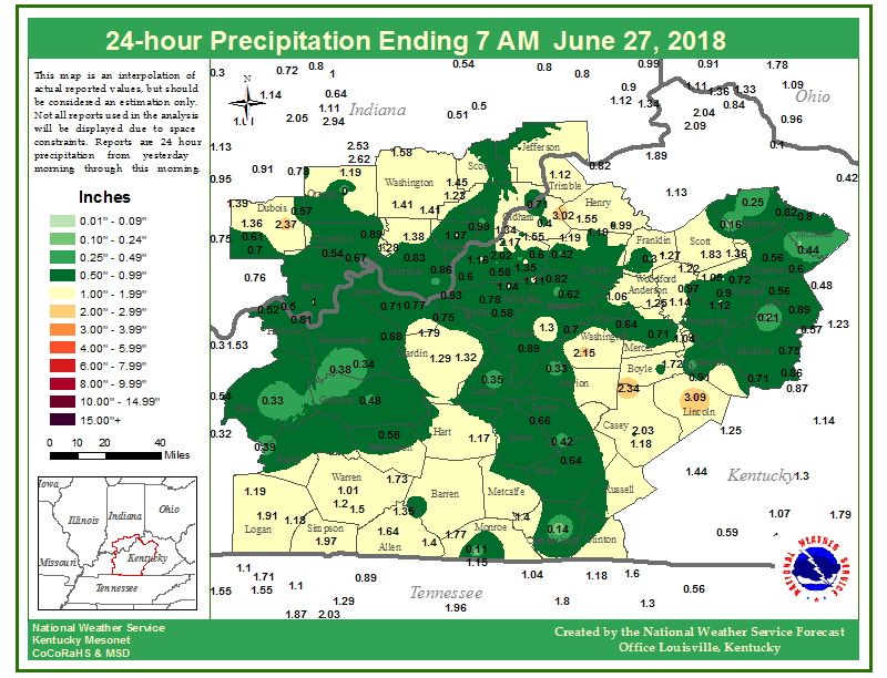
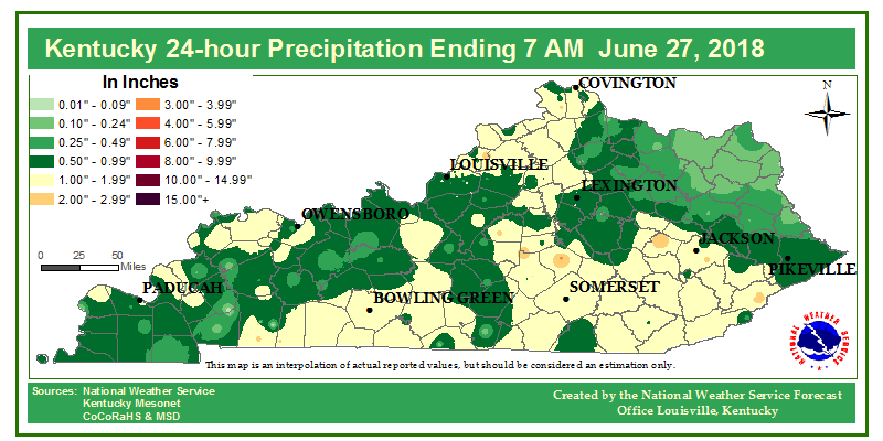
Rain Reports
 |
Media use of NWS Web News Stories is encouraged! Please acknowledge the NWS as the source of any news information accessed from this site. |
|


 Weather Story
 Weather Map
 Local Radar