Louisville, KY
Weather Forecast Office
|
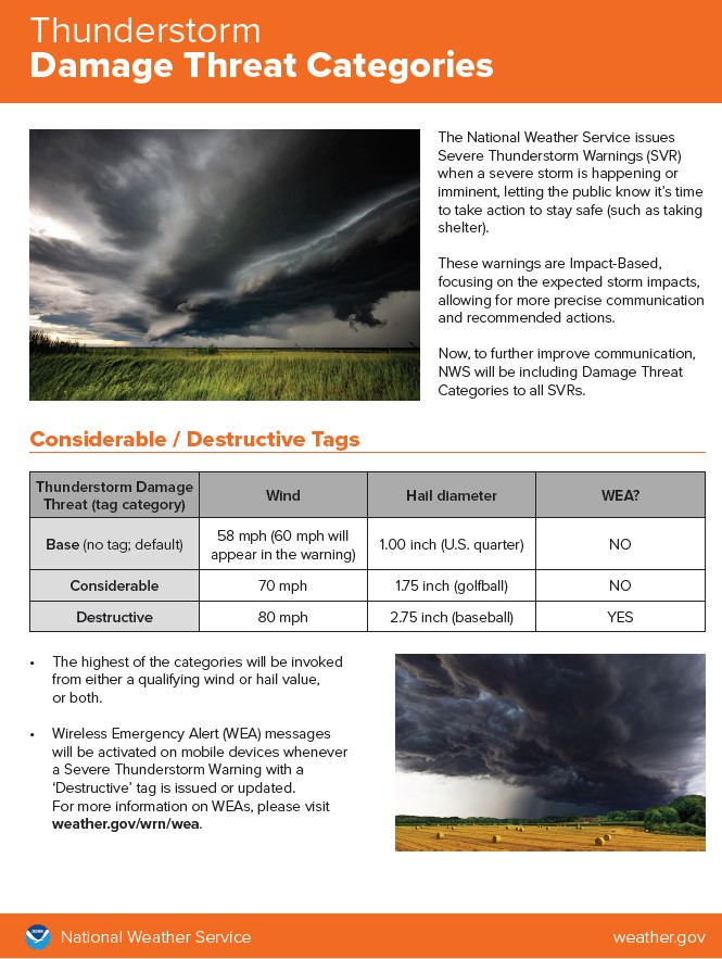
Severe Thunderstorm Warnings Severe Thunderstorm Warnings (SVR) will have new damage threat categories at the bottom of the product. If a storm is expected to produce golf ball sized hail and/or 70 mph winds, the additive data at the bottom of the warning will include a "CONSIDERABLE" tag. If the storm is expected to produce at least baseball sized hail and/or 80 mph winds then the SVR will carry a "DESTRUCTIVE" tag. SVRs and Severe Weather Statements (SVS) with the DESTRUCTIVE tag will be recommended to activate Wireless Emergency Alert on mobile devices. For more information see https://www.weather.gov/media/notification/pdf2/scn21-22svr_ibw_aab.pdf . Click on the image to the right for a larger version. |
 |
|
Special Weather Statements Special Weather Statements (SPS) will now be formatted in a similar way as Severe, Tornado, and Flash Flood Warnings. The SPS product will use a bullet format and include succinct "HAZARD", "SOURCE", and "IMPACT" sections, along with tags at the bottom of the product for expected hail size and wind gust speeds. SPSs are issued for storms that are not severe but may still cause negative societal impact. NWS offices that have issued Significant Weather Advisories as SPS products will no longer do so. (NWS Louisville has not issued Significant Weather Advisories.) What had formerly been Significant Weather Advisories will now use the same format as all other SPSs. |
|
Current Hazards
Hazardous Weather Outlook
Storm Prediction Center
Submit a Storm Report
Advisory/Warning Criteria
Radar
Fort Knox
Evansville
Fort Campbell
Nashville
Jackson
Wilmington
Latest Forecasts
El Nino and La Nina
Climate Prediction
Central U.S. Weather Stories
1-Stop Winter Forecast
Aviation
IDSS Forecast Points
Air Quality
Fire Weather
Recreation Forecasts
1-Stop Drought
Event Ready
1-Stop Severe Forecast
Past Weather
Climate Graphs
1-Stop Climate
CoCoRaHS
Local Climate Pages
Tornado History
Past Derby/Oaks/Thunder Weather
Football Weather
Local Information
About the NWS
Forecast Discussion
Items of Interest
Spotter Training
Regional Weather Map
Decision Support Page
Text Products
Science and Technology
Outreach
LMK Warning Area
About Our Office
Station History
Hazardous Weather Outlook
Local Climate Page
Tornado Machine Plans
Weather Enterprise Resources
US Dept of Commerce
National Oceanic and Atmospheric Administration
National Weather Service
Louisville, KY
6201 Theiler Lane
Louisville, KY 40229-1476
502-969-8842
Comments? Questions? Please Contact Us.


 Weather Story
 Weather Map
 Local Radar