January 17, 2012
County: Dubois
EF-Scale: EF0
Deaths: 0
Injuries: 0
Path width: 25 yards
Path length: 0.1 mile
Time: 9:44am EST
Notes: Touched down 2.7 miles southwest of Huntingburg. An outbuilding was destroyed and debris was scattered for a quarter mile.
January 17, 2012
County: Dubois
EF-Scale: EF1
Deaths: 0
Injuries: 0
Path width: 100 yards
Path length: 9 miles
Time: 9:54am EST
Notes: This tornado touched down three miles northeast of Huntingburg, destroying a barn and blowing several outbuildings off their foundation. The tornado skipped east-northeast for nearly 9 miles across primarily open fields. Structural damage occurred along IN-162 where over 50 feet of a 600 foot long commercial outbuilding was destroyed. One-half mile east of IN-162, numerous outbuildings were damaged and a small grain hopper was toppled. Continuing east-northeast, a roof was blown off of one barn and another barn had roof sections peeled off on St. Anthony Road West. Occasional uprooted and snapped trees occurred for an additional 5 miles before the tornado dissipated after destroying a 40 by 50 foot tool shed 1.6 miles south-southeast of Celestine.
January 17, 2012
County: Jefferson IN
EF-Scale: EF0
Deaths: 0
Injuries: 0
Path width: 60 yards
Path length: 0.3 mile
Time: 10:40am EST
Notes: An EF-0 tornado touched down at the Madison Municipal Airport. Damage was confined to IMS Lane. The tornado touched down briefly along this path and moved an at least 500 pound dumpster 35 feet southeast. It also moved a Beechcraft/King Air plane 10 degrees and the nose gear was broken. The airport operations building had a disabled awning and post. Part of a hangar`s siding came off with siding and insulation up in trees. Several trees were snapped along the narrow path. A witness saw the swirl as the tornado touched down.
January 17, 2012
County: Floyd
EF-Scale: EF1
Deaths: 0
Injuries: 0
Path width: 50 yards
Path length: 1.2 miles
Time: 11:00am EST
Notes: EF-1 tornado first touched down on East Riley Rd. in Floyds Knobs, where a garage was destroyed. The tornado continued east across the Knobs toward Binford Rd, where it took multiple trees down. The tornado crossed Paoli Pike just north of I-265 and caused roof damage at the Knob Point Apartments.
January 17, 2012
County: Clark IN
EF-Scale: EF0
Deaths: 0
Injuries: 0
Path width: 30 yards
Path length: 1.9 miles
Time: 11:06am EST
Notes: An EF-0 tornado first touched down at the Wal-Mart parking lot on the northwest corner of the Veteran`s Parkway near I-65. A vehicle was turned over on I-65, then the tornado skipped over an area before coming down again on a subdivision to the east, with damage occurring along Belmar Dr and Meadows Dr as well as at the intersection of Kingsfield St and Crown Ct. It took down several fences, with evidence of cyclonic circulation. It lifted again before coming down and taking the roof of a barn on Armstrong Rd.,where the tornado ended.
January 17, 2012
Counties: Jefferson KY, Oldham
EF-Scale: EF1
Deaths: 0
Injuries: 1
Path width: 250 yards
Path length: 8.2 miles
Time: 11:12am EST
Notes: The tornado touched down near the intersection of I-264 and Brownsboro Road. The tornado tracked northeast to near the intersection of Hurstbourne Lane and Brownsboro Road where it briefly lifted. The tornado then reformed and crossed I-265 and continued to the east-northeast through several subdivisions north and northeast of Fincastle. The tornado crossed into Oldham County, moving through Orchard Grass Hills and lifting at the northern tip of Clore Lane. Damage indicators along the path of this tornado included multiple softwood trees down, minor shingle damage to homes, a side wall downed in a large indoor tennis facility, and a barn roof collapse. An injury occurred as the tornado crossed I-265 when two semi trailers were blown over. The driver of one of the trucks was injured.
January 17, 2012
County: Jefferson KY
EF-Scale: EF-1
Deaths: 0
Injuries: 0
Path width: 90 yards
Path length: 0.2 mile
Time: 11:20am EST
Notes: An EF-1 tornado touched down just to the north of the intersection of Stony Brook Drive and Hurstbourne Parkway. The tornado traveled north-northeast along Stony Brook Drive and lifted near the intersection of Stony Brook and Laverne Drive. Numerous trees were snapped along the path. Siding and shingles were blown off of multiple houses. On Michael Edward Drive the garage door was blown in on a detached garage and the roof was lifted off and shifted a foot.
January 17, 2012
County: Scott KY
EF-Scale: EF-1
Deaths: 0
Injuries: 0
Path width: 75 yards
Path length: 0.5 mile
Time: 12:12pm EST
Notes: This tornado touched down at 338 Soards Road and moved northeast, lifting as it began to cross a small lake. A well-anchored 50x20 three bay barn was destroyed and scattered in three directions. A 20x30 barn was also destroyed, and a third small barn along the path was damaged. Numerous trees were blown down, snapped, or uprooted. Fences were torn down as well. This survey was conducted by personnel from both the NWS and emergency management from Franklin and Scott Counties.
January 17, 2012
Counties: Simpson, Allen
EF-Scale: EF-2
Deaths: 0
Injuries: 0
Path width: 150 yards
Path length: 9 miles
Time: 12:20pm CST
Notes: This tornado touched down near Hickory Flat Road just south of its intersection with Hickory Flat-Ridge Road in Simpson County where about a dozen trees were uprooted. The most significant damage occurred near the intersection of McKendree Church Road and Highway 100 where a well constructed brick house completely lost its roof. Multiple barns, garages, and outbuildings were destroyed here as well. Nearly a complete roof of one outbuilding was project 1/2 mile to the east. Another area of significant damage was at the intersection of Highway 100 and Reeder School Road (near the Simpson/Allen County line) where a house had significant roof damage and had an exterior wall blown out. A jeep in the driveway was blown into the house and a camper was blown from the driveway across the road with debris scattered through the field beyond. Damage continued east into Allen County with the last evidence of damage at Walker Chapel Road about a mile south of Highway 100.
February 29, 2012
County: Hardin
EF-Scale: EF-2
Deaths: 0
Injuries: 0
Path width: 250 yards
Path length: 5 miles
Time: 9:55am EST
Notes: The tornado began as a 125 yard tornado near 4510 Gather Station Road damaging a barn and traveled towards New Glendale Road and Overall Phillips Road damaging some homes and knocking down many trees and fences. The storm crossed I 65 and surprisingly did not strike any vehicles. The twister struck several homes lifting many roof structures off of Wildwood Drive and Sportmans Lake Road. It increased in width to 250 yards and struck the Harry Owen trucking company buckling roof trusses and spreading significant debris over the Lincoln Parkway into the mobile home park. Next it destroyed a working garage and did significant damage to 3 homes off of Hodgenville Road and uprooting and twisting many trees before lifting a couple of hundred yards downwind.
February 29, 2012
County: Grayson
EF-Scale: EF-2
Deaths: 0
Injuries: 0
Path width: 200 yards
Path length: 2 miles
Time: 9:42am CST
Notes: The tornado began as a narrow tornado east of Clarkson just south of Highway 224. The storm increased in width to 200 years and struck several single and double wide mobile homes south of Millerstown road. All 3 mobile home became airborne, with one traveling over 400 yards. One manufactured home was thrown 50 feet into a tree and fence with a man inside it. He was medically airlifted to Louisville. The tornado next struck a large area of soft and hardwood trees before striking a solid brick home just west of Horntown with the roof removed and exterior walls either damaged or destroyed. The tornado damaged struck the Horntown convenience store damaging the roof. During the end of the tornadoes life cycle it narrowed and bounced striking several trees and knocking over several cemetery headstones and uprooted 2 large trees at the Little Clifty United Methodist Church just west of Lacon. The tornado lifted in a grove of trees about 250 yards east of the church.
February 29, 2012
County: LaRue
EF-Scale: EF-2
Deaths: 0
Injuries: 0
Path width: 200 yards
Path length: 1.7 miles
Time: 11:05am EST
Notes: A National Weather Service Survey Team in conjunction with Larue County EMA determined a tornado began near Kyle Lane which is 2 miles west of Hodgenville. It began as a very narrow 80 yard tornado as a mainly elevated funnel cloud/tornado near tree top level. It did some minor roof and shingle damage...uprooted some cedar trees and damaged some fencing. The tornado crossed Tanner Road and lifted just west of downtown Hodgenville. The tornado was rated an EF1 at this location. The length of this touchdown was .90 miles. The same tornado once again touched down on the east side of main street at the State Farm Insurance agency and Citizens Union Bank. This tornado touchdown was much stronger. Two cars moved several feet and were turned 45 degrees with one on top of the other in the State Farm parking lot. The tornado increased in width to 200 yards on Wobegon Way significantly damaging several homes. This included large sections of roof structure being removed and exterior walls collapsing at 202 Woebegone Way. It went into a wooded area narrowing in Miami Court to about 75 yards and becoming more elevated. It damage many roofs with the heaviest damage at a day care center in a residential home off Miami Court. The twister knocked down many power lines down and twisted and snapped trees and did roof damage to several homes and then crossing highway 210. Next it snapped and uprooting some trees and doing some roof damage to a couple of homes before lifting 200 yards downwind. The length of this touchdown was .80 miles. A second tornado touched down just south of Woebegone Way in a wooded area. Another information statement will follow shortly.
February 29, 2012
County: LaRue
EF-Scale: EF-2
Deaths: 0
Injuries: 0
Path width: 100 yards
Path length: 0.9 mile
Time: 11:12am EST
Notes: A National Weather Service Survey Team in conjunction with Larue County EMA determined a second tornado just south of Miami Court and moved east through a wooded area. Several witnesses saw two different tornado near the Miami Court and Wobegone Way area. The second funnel cloud/tornado was near tree top level. It was only 50 yards wide twisting many trees and was rated a EF0. As it crossed Highway 210 the twister increased to 100 yards wide and became stronger. It damaged a large working garage and damaged two homes off of Highway 916 including a new well, almost finished new constructed home which experienced significant exterior wall damage. Workers working on the home heard a loud roar while seeking shelter and observed the twister striking and uprooting some trees. A dumpster full of old building material was thrown 75 yards and snapped one telephone pole. The twister lifted in a field a couple of hundred yards downwind. The twister was rated EF2 at this location.
February 29, 2012
County: Metcalfe
EF-Scale: EF-1
Deaths: 0
Injuries: 0
Path width: 150 yards
Path length: 1.1 miles
Time: 12:47pm CST
Notes: The EF-1 tornado touched down southeast of Center, Kentucky near Herbert Hodges Road. It damaged 3 to 4 barns and snapped numerous trees along its 1.1 mile path. The tornado lifted 1.5 miles east-southeast of Center, Kentucky.
February 29, 2012
County: Russell, Casey
EF-Scale: EF-2
Deaths: 0
Injuries: 0
Path width: 150 yards
Path length: 7.2 miles
Time: 1:22pm CST
Notes: The tornado first touched down north of Russell Springs in northern Russell County west of Highway 127 where it did minor damage to trees, barns, and outbuildings. The tornado then intensified as it moved east with the worst damage occurring along a 1.5 mile stretch from Highway 76 east over Oak Grove Road to Pattie Ridge Road. On Highway 76, two mobile homes were totally destroyed and a modular home was rotated 30-80 feet counterclockwise off its foundation (with a quarter of the home blown away). Two residents survived in an underground tornado shelter where they took refuge having heard of the warning via sirens and phone calls 3-5 minutes before the tornado destroyed their homes. Residents were not home at the time of the tornado at the other homes destroyed along its path. The tornado then weakened as it moved into southern Casey County where it damaged more trees, barns, and outbuildings. The tornado finally lifted west-southwest of Windsor leaving a 7.2 mile track.
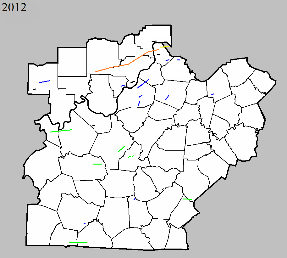
March 2, 2012
Counties: Washington IN, Clark IN, Scott IN, Jefferson IN, Trimble
EF-Scale: EF-4
Deaths: 11
Injuries:
Path width: 700 yards
Path length: 49 miles
Time: 2:50pm EST
Notes: Washington County: The National Weather Service in conjunction with Washington County Emergency Management conducted a detailed tornado damage survey on Saturday, March 3. Below are the results.
The tornado first touched down on the south side of Fredericksburg just south of U.S. 150 where several trees were snapped off. In this area, winds were estimated to be 90 mph (EF1) with a damage width of 30 yards along the south fork of the Blue Lick River.
Additional tree damage was observed as the tornado moved east- northeast across farmland. Near the intersection of Horners Chapel Road and Fredericksburg Road, a high tension metal power structure was toppled along with numerous trees uprooted and snapped. Here, damage was estimated as EF2 with 130 mph winds. Along Palmyra Road near Strickland Road, several trees were snapped with EF1 damage 50-100 yards wide and estimated winds of 100-110 mph. High tension wires were down and trees snapped along West End Road just north of Shanks Hill Road.
The tornado then traveled over a ridge and intensified as it hit State Route 135 at Dutch Creek Road. Here, large chunks of 5- or 6-inch thick asphalt from an approximately 4-by-4-yard section of roadway were blown 10 to 30 yards into the adjacent grass next to the road. Just east of Route 135, tremendous tree damage was observed. At this location, the tornado was estimated to be of EF3 strength with 150 mph winds. The width of the damage path also began to widen, increasing to 200 yards.
Tree and structural damage was widespread northeast of Route 135 as the tornado crossed Trainer Lane and then State Road 335 to Robbs Lane. The width of observable damage increased to one-quarter to one-third of a mile. Countless trees were snapped and uprooted. The degree of damage suggested a mix of EF2 and EF3 damage in this area, with estimated winds of 120-150 mph.
The tornado crossed U.S. 60 just south of New Pekin. Immediately east of the highway, tremendous structural damage was observed. A well-constructed and large factory building (Airgo Industries) was cleared to its foundation slab with numerous anchoring bolts bent in the direction of the storm. Debris from this building was observed one-half to three-quarters of a mile downwind. Large power poles were snapped. Another metal out building on the right periphery of the damage path had sheeting pulled off the back of the building apparently from the force of the inbound winds into the tornado. This was the area where 5 people were tragically killed in a mobile home. In this location just east of U.S. 60, damage suggested an EF4 tornado with 170 mph estimated winds, and a width of observed damage from 0.3-0.4 mile.
Damage continued to the east along and south of Hurst Road in extreme southeast Washington County. The tornado crossed into extreme northwest Clark County along and near Daisy Hill Road. In this area, a well-constructed one-story brick house at the top of a small ridge was completely destroyed with no walls standing. People onsite reported that cows were missing and could not be located. They also stated that the tornado looked like a black wall as it approached. A heavy trailer cab was blown from this house to another demolished brick home about one-quarter mile away. Damage here suggested EF4 damage with 170 mph winds.
As the tornado re-entered Washington County near the intersection of Daisy Hill Road and Williams Knob Road, widespread damage occurred. This included a home which was totally leveled as well as a couple of anchored down double wide trailers. A car was destroyed and tossed about 100 yards in the direction of storm motion from its origin at the home. At one of the destroyed trailers, a Dodge Ram pickup truck was tossed onto its side and destroyed in the opposite direction from the car (i.e., on the left side of the tornado track). Here, EF3-EF4 damage was estimated with winds of 150-170 mph. There were also snapped trees and structural damage along Whiskey Run Road. The width of the observed damage straddling the Washington-Clark County line was estimated to be one-third to one-half mile wide, although the width of the most concentrated damage was narrower. The last observed damage in Washington County was near S. Flatwood Road in a wooded area before the tornado entered Clark County.
Across Washington County, particularly east of IN 135, thousands of trees were uprooted and snapped.
Clark County and Scott County: The National Weather Service in conjunction with Clark County Emergency Management conducted an exhaustive tornado damage survey on Saturday and Sunday, March 3 and 4. Below are the results. The tornado continued east-northeast in far northwest Clark County on Dan Gray Road where the twister leveled many well-built homes and caused extensive tree damage. The tornado here was rated EF4 with estimated wind speeds of 170 mph and a damage width of one-third mile.
The tornado moved into far southeast Washington County before reappearing in Clark County. In Clark, the damage width narrowed to one-quarter mile as the tornado crossed Pixley Knob Road and decreased in intensity to EF2 with wind speeds of 115-120 mph.
Farther east, the tornado intensified again as it destroyed two double wide homes on Speith Road. One family residence on the west side of the road was severely damaged, reflecting EF3 damage with 150 mph winds.
The tornado crossed Interstate 65, damaging several vehicles and semis and closing the interstate for several hours. Several people were trapped in these vehicles, but were later rescued.
The tornado continued to strengthen just east of Exit 19 of Interstate 65 in a heavily industrialized area. Here, buildings containing several businesses were severely damaged. A home was destroyed on the east side of North Fraucke Road. The violent tornado also seriously damaged several homes on the north side of State Highway 160. Here, there was evidence of multi-vortex structure with EF4 damage and 175 mph estimated winds.
The tornado then struck the south buildings of the Henryville middle and high school complex, with severe damage and 170 mph winds (EF4). The middle school experienced the worst damage. The cafeteria was completely destroyed. Two school buses were ripped off their chassis.
There was also extensive structural damage on the east side of Henryville on North Front Street and Pennsylvania Street. A high tension tower and other homes were damaged on Pine Drive. Incredible tree damage also occurred just west of Pine Drive as the tornado traveled up a ridge. In this region, the tornado was an EF3 with 150 mph winds.
On Brownstown Road, many homes were severely damaged especially on the north side of the tornado track with estimated speeds of 150 mph (EF3). Farther east, there was massive deforestation on the east side of a ridge just west of and along Henryville Otisco Road. Several more homes were severely damaged along this road. One of these homes reflected EF4 damage and 170 mph winds.
The tornado rapidly narrowed to a rope-like structure and ended as an EF1 with 90-95 mph winds and an 80 yard wide path. This occurred near the intersection of Blackberry Trail and State Highway 3.
Simultaneously, a new cyclic tornado vortex rapidly formed from the same supercell near Mahan Road and Old State Road 3 immediately southwest of the first tornado. The second tornado began as an EF1 and damaged a church and a few trees. The vortex quickly intensified to EF3 strength as it crossed the south portion of the town of Marysville, severely damaging several homes.
East of Marysville, another cyclic vortex from the parent storm formed just southwest of the intersection of Nabb New Washington Road and Nabb Marysville Road. This vortex intensified and merged with the primary circulation. The tornado severely damaged or destroyed several houses and double wide mobile homes around the intersection of Nabb New Washington and Nabb Marysville. Debris from the double wides was tossed around a mile downwind. The tornado was rated EF3 here with 150 mph winds and a damage width of one-third mile.
A Civil Air Patrol flight on Sunday, March 4 revealed extensive ground scouring in farmers` fields east of Marysville all the way to the Jefferson-Scott County line. This scouring was evidence of a multi-vortex tornado, which was confirmed by multiple videos and photographs.
The tornado continued north of Barnes Road, damaging several clusters of trees in open country. The tornado intensified east of the intersection of Kettle Bottom and State Highway 362.
In Scott County, immediately north of Highway 362 and east of Concord Road, three homes were severely damaged while five double wide mobile homes were completely destroyed. Here, the tornado was an EF4 with 170 mph winds. Just south of 362 in Clark County, two additional homes and power poles were damaged greatly. From there, the tornado crossed into Jefferson County, Indiana.
Jefferson County: The National Weather Service in conjunction with Jefferson County, IN Emergency Management conducted the tornado damage survey in Jefferson County. The tornado traveled from Clark County, Indiana across extreme southeast Scott County and into far southern Jefferson County. Damage was observed along and just north of State Highway 362 near the 3-county line. This included several mobile homes totally destroyed, several framed houses heavily damaged, tremendous tree damage, and power poles snapped and shredded. The observed damage width was one-third of a mile with estimated winds of 170 mph (EF4).
The tornado traveled east-northeast snapping trees and power poles on County Road 850, and did its most significant damage at the intersection of Jackson Road, State Highway 62, and Swan Road about 2 miles south of the town of Chelsea.
In this area, several well-built brick homes were destroyed. The homes had anchor bolts attached to steel plates and a concrete foundation. One house was lifted and slid 65 yards off its foundation while mostly still intact. Another home was completely demolished and thrown downwind several hundred yards, within which there were 3 fatalities. The garage of this house was destroyed with one vehicle thrown 30 yards and another tossed 75 yards. A piece of farm equipment was thrown 200 yards as well. A third well-built brick home had its roof completely lifted and thrown over 300 yards downwind. Also, an above ground pool half filled with water was missing. Wind speeds in the area were estimated at 170-175 mph (EF4) with a damage width of one-quarter mile.
The tornado tracked to the north of Paynesville and south of Lee Bottom, extensively damaging forests in southern Jefferson County before crossing the Ohio River into Trimble County, Kentucky. The damage width narrowed in this area to only a couple hundred yards.
Trimble County: The National Weather Service in conjunction with Trimble County Emergency Management conducted an extensive tornado survey in Trimble County. The tornado crossed the Ohio River from Jefferson County, Indiana and narrowed to about 200 yards wide. The tornado damaged a home on Rodgers Road, overturned two barns, and uprooted and/or twisted several trees. This was consistent with EF1 damage and 105-110mph estimated winds.
At the same time a second vortex formed immediately adjacent to the first vortex and totally destroyed a barn on Rodgers Road and extensively damaged another. This tornado also damaged a lot of rugged forested area before intersecting with the path of the first vortex near the confluence of Highway 1838 (Corn Creek Road, Highway 625, and Joyce Mill Road. In this area the tornado was rated as an EF2 with 115 mph estimated winds.
Three single-wide mobile homes near the intersection of Joyce Mill Road and Highway 625 were destroyed along with tree damage and downed power lines and poles. This was consistent with EF1 damage, 105 mph estimated winds, and a damage width of 75 yards.
No evidence of further damage was observed until Rawlett Lane, where some trees were snapped and uprooted. There could have been damage in-between although the survey team was unable to access this area. The tornado then struck two homes and a single-wide mobile home on New Hope Ridge Road (Highway 2870) about 1.5 miles west of Highway 421. Here EF1 damage, 90 mph winds, and a path width of 50 yards were estimated. The tornado lifted near this location.
March 2, 2012
County: Clark IN
EF-Scale: EF1
Deaths: 0
Injuries: 0
Path width: 60 yards
Path length: 6.5 miles (skipping)
Time: 3:30pm EST
Notes: Photographs taken during a Civil Air Patrol flight corroborate interviews with residents along the damage path that there were intermittent touchdowns of a weaker tornado with the second supercell to pass over the area (see previous tornado). The second storm, which pummeled the recently devastated area with hail up to the size of softballs, followed nearly the same path as the first supercell. At least three locations along the path of this storm support the occurrence of a tornado of EF-1 intensity, with maximum winds approaching 110 mph, an intermittent path length of 6.5 miles, and a damage path width of 60 yards. The first observed damage was near Round Knob in the Clark State Forest. Damage was again observed along and west of Speith Road, 1/4 of a mile north of Henryville-Blue Lick Road just southwest of Henryville. Finally, the tornado lifted after doing damage from the south side of Henryville near Robyn Avenue to the east side of Henryville at the intersection of Highway 160 and Haddox Road.
March 2, 2012
Counties: Hancock, Breckinridge
EF-Scale: EF-2
Deaths: 0
Injuries: 0
Path width: 200 yards
Path length: 17.4 miles
Time: 2:38pm CST
Notes: Aerial photos were matched perfectly with radar signatures to determine that the initial start point of the tornado occurred 4.5 miles south southwest of Hawesville in Hancock County along route 2181. Vinyl siding was ripped off a home and small outbuildings were damaged. The tornado continued east across route 69 toward Cloverport, intermittently touching down and doing damage to small outbuildings. 4 miles west of Cloverport, additional minor damage was done to a group of homes along 2169. Minor damage to buildings occurred just on the western outskirts of Cloverport, then the tornado lifted over the town, touching down again less than a mile east of the community, where numerous hardwood trees were observed to be uprooted from aerial photos. All of the damage was consistent with EF-0 wind speeds between 70 and 80 mph.
The National Weather Service would like to thank volunteer general aviation pilots Mark Powers and Josh Kieffer for flying the damage path in N16NA and Austin Lassell for aerial photography. The pilots are associated with the Kentuckiana Volunteer Aviators.
The tornado track continued at a residence on New Bethel Cloverport Rd. where 2 structures were destroyed. This damage is consistent with an EF-2 tornado and 110 to 115 mph winds. The tornado continued east to near B Flood road with additional structural damage consistent with EF-1 damage and 90 mph winds.
Tree damage continued along the path with additional EF-2 damage occurring at two chicken farms where a 200 yd long chicken barn was destroyed and hundreds of chickens were killed and/or lost. This is consistent with EF-2 damage and 120 mph wind. An additional smaller chicken coop also sustained damage at the end of Silas Miller Road, consistent with EF-1 damage.
The end of the path was surveyed east at Hwy 259 where another metal structure was damaged and several trees where downed. This damage was consistent with EF-1 damage and 90 mph winds.
March 2, 2012
Counties: Trimble
EF-Scale: EF-3
Deaths: 0
Injuries: 0
Path width: 75 yards
Path length: 3.4 miles
Time: 3:41pm EST
Notes: The National Weather Service in conjunction with Trimble County Emergency Management and an aerial survey conducted by pilots from the Kentuckiana Volunteer Aviators confirmed that a tornado touched down about 5 miles SSE of Milton, just west of the Milton volunteer fire station number 2 on Highway 421. This is just NE of the intersection of Hwy 2870 and 421. The tornado touched down at approximately 3:38 PM EST, and the initial damage included snapped and twisted trees just west of Hwy 421.
The tornado rapidly increased in intensity as it moved to the east, directly striking the Milton volunteer fire station number 2. The fire station was heavily damaged, with the collapse of rigid frames. A 4000 pound trailer (concession trailer) was moved 30 yards, while a Ford pickup truck was moved 60 yards. The tornado was 60 yards wide with wind speeds of 140 mph, indicative of EF-3 strength. The tornado tracked to the east with extensive damage of trees along Hwy 1226. The tornado weakened to an EF-1 at 871 Palmyra Rd. and at 2130 Palmyra Rd. and narrowed to about 50 yards. Witnesses describe this as a very narrow, skipping tornado. Pictures confirm this.
Witnesses saw one vortex coming down from the apparent wall cloud and quickly lifting before a new vortex came down nearby. On Culls Ridge Road, the tornado strengthened to an EF-3 once again with 140 mph winds. It damaged two homes with many exterior walls partially collapsing. The most significant damage here was an electrical transmission line which collapsed a metal truss tower and snapped several power poles in a path width of 70 yards. The tornado weakened from there to an EF-1 tornado, damaging trees as it crossed into Carroll County with wind speeds in far eastern Trimble County of 85-90 mph.
March 2, 2012
Counties: Trimble
EF-Scale: EF-1
Deaths: 0
Injuries: 0
Path width: 100 yards
Path length: 2.7 miles
Time: 4:01pm EST
Notes: The National Weather Service in conjunction with Trimble County Emergency Management and an aerial survey conducted by pilots from the Kentuckiana Volunteer Aviators confirmed that an EF-1 tornado touched down on Willard Wilson Road in southern Trimble county at 401 PM EST. At this location, the tornado destroyed a 30 by 60 foot old barn and a single wide home. Along with the destroyed homes, one large Oak tree was downed along with several other smaller trees. Further down on Willard Wilson road, another 30 by 50 foot barn was collapsed and a 400 pound 4-wheeler was moved 30 feet. Shingle damage occurred to a home in this location. The tornado moved east-northeast to Hi-Grove Hill Road where the strongest (100 mph) winds occurred. There was a very concentrated area of trees snapped, along with a gutter ripped off a house and power line down. Finally, the tornado traveled to
Carmon Creek Road where several hardwoods were snapped along with power lines down. This area is just northwest of the US 421 and I-71 junction near the Trimble/Henry county line.
March 2, 2012
Counties: Meade
EF-Scale: EF-0
Deaths: 0
Injuries: 0
Path width: 30 yards
Path length: 0.75 mile
Time: 4:02pm EST
Notes: The National Weather Service in conjunction with Meade County Emergency Management has determined that an EF-0 tornado with maximum wind speeds of 75 mph briefly touched down just east of the Breckinridge/Meade county line in Meade county. The tornado was photographed from Ekron, looking southwestward. Aerial photos of damage were also taken by volunteer general aviation pilots Mark Powers and Josh Kieffer and aerial photographer Austin Lassell in aircraft N16NA. The pilots were associated with the Kentuckiana Volunteer Aviators. Both the aerial photos and picture of the tornado relayed by the emergency manager were matched up with a radar signature indicating rotation. The tornado touched down near the Hill Grove and Guston area on the south side of U.S. 60, blowing a porch off the side of a house. A sign was also blown down at a business along U.S. 60.
March 2, 2012
Counties: Henry
EF-Scale: EF-1
Deaths: 0
Injuries: 0
Path width: 40 yards
Path length: 0.25 mile
Time: 4:12pm EST
Notes: The National Weather Service in conjunction with an aerial damage survey performed by pilots David Katz and Gary Katz and photographer Tom Boucher from the Kentuckiana Volunteer Aviators determined that an EF-1 tornado touched down in northern Henry county on Friday, March 2nd. A thin path of downed trees coincident with a circulation observed on radar was surveyed by the pilots. Numerous trees were uprooted near a pasture east of Port Royal-English Road.
March 2, 2012
Counties: Warren
EF-Scale: EF-1
Deaths: 0
Injuries: 0
Path width: 60 yards
Path length: 0.5 mile
Time: 4:06pm CST
Notes: Straight line winds along and north of the supercell moving through Simpson County uprooted shallow-rooted hardwood and softwood trees and destroyed a tool shed on Evans Rd. As it moved into Warren County, it damaged barn roofs and produced golf ball size hail which penetrated siding on numerous vinyl sided houses. As it reached 961 east of Alvaton in Warren County, it spawned an EF1 tornado with winds estimated at 95 mph destroying a barn and tool shed.
March 23, 2012
County: Jefferson, KY
EF-Scale: EF-1
Deaths: 0
Injuries: 0
Path width: 70 yards
Path length: 2.5 miles
Time: 2:07pm EDT
Notes: This tornado touched down just north of the intersection of Cedar Creek Road and Mount Washington Road, and lifted just northeast of the intersection of Cedar Creek Road and Long Rifle Lane. The most significant damage was done on Brook Chase Court, about in the middle pf the path.
March 23, 2012
County: Shelby
EF-Scale: EF-1
Deaths: 0
Injuries: 0
Path width: 50 yards
Path length: 2.25 miles
Time: 2:28pm EDT
Notes: The tornado traveled mainly over plowed fields, but was witnessed by at least three people and did do some damage to farms. Two barns were destroyed, two barns suffered significant roof and structural damage, and about two dozen trees were snapped or uprooted.
May 1, 2012
County: Trimble
EF-Scale: EF0
Deaths: 0
Injuries: 0
Path width: 15 yards
Path length: 1.9 miles
Time: 4:45pm EDT
Notes: This weak tornado did tree damage as it briefly touched down along Mount Pleasant Road northwest of Bedford, snapping upper-level tree branches in a narrow path. Occupants of a mobile home witnessed the tornado as it approached from the west, and they took shelter in their bathroom. While a large tree next to their home crushed a pickup truck as it came down, their home sustained minimal damage.


 Weather Story
 Weather Map
 Local Radar