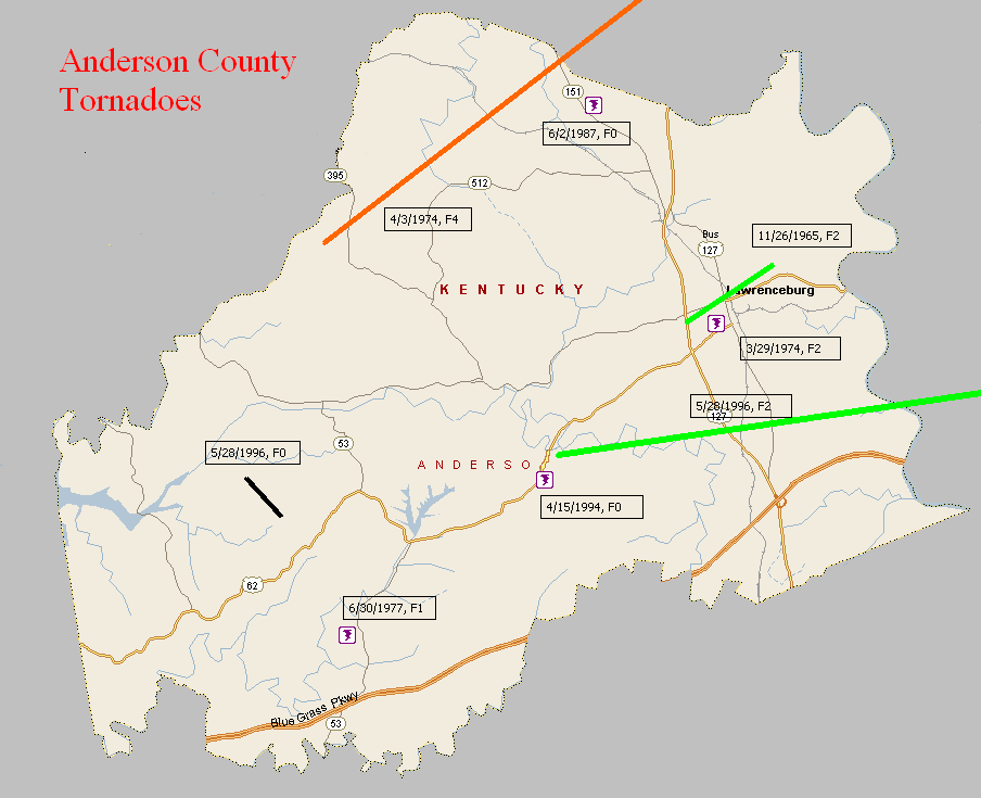
November 26, 1965
Counties: Anderson
F-scale: F2
Deaths: 0
Injuries: 8
Path width:
Path length: 3 miles
Time: 11:05pm
Grazulis narrative: Moved northeast from west of Lawrenceburg to the edge of town. A trailer was demolished, and the occupants were severely injured. A brick building was unroofed and had a wall blown down. Many buildings had roof or other damage.
Noted discrepancies: SPC, NCDC, and Storm Data give a path length of 3 miles, Grazulis gives 6 miles. SPC gives a path width of 10 yards, NCDC 30 yards, Storm Data 500 yards, Grazulis nothing. Grazulis times this tornado one hour later (12:05am November 27)...could be a time zone issue here (either with Grazulis or the NWS).
Notes: Storm Data says this tornado touched down initially west of Lawrenceburg and moved into the downtown section of that city. The storm then lifted but came back down at the eastern edge of town. According to news accounts, damage was heavy in Lawrenceburg, especially in a three-block wide swath through downtown. The Anderson County courthouse lost some of its roof.
March 29, 1974
Counties: Anderson
F-scale: F2
Deaths: 0
Injuries: 2
Path width: 100 yards
Path length: 2 miles
Time: 8:00pm
Grazulis narrative: A trailer and a barn were destroyed at Lawrenceburg. A home was unroofed, and other buildings were damaged.
Noted discrepancies: SPC and NCDC give a path length of 1 mile, Grazulis and Storm Data give 2 miles.
April 3, 1974
Counties: Anderson, Franklin, Scott KY
F-scale: F4
Deaths: 4
Injuries: 122
Path width: 800 yards
Path length:
Time: 4:50pm
Grazulis narrative: Moved northeast near Alton, passing along the south and southeast edge of Frankfort, where homes were leveled and four people were killed. About 120 homes were damaged or destroyed near Frankfort, as were businesses and factories. Twelve homes were destroyed near Alton. The funnel passed near Stamping Ground and lifted near Sadieville.
Noted discrepancies: NCDC does not give a liftoff lat/lon. SPC gives a path length of 79 miles...NCDC gives 81 miles (including 54 miles in Scott County, which is impossible), and Grazulis gives 36 miles. NCDC/SPC start this tornado on the western Anderson County line west of Gee...Grazulis starts it in Anderson County but farther east at Alton. SPC gives a path width of 10 yards, NCDC 30 yards, Grazulis 800 yards. Grazulis probably has the most correct path width. For this mapping project we used the official start/stop lat/lons, but further research is needed to verify. (The ending lat/lon given by NCDC for the Franklin County portion of the track is wrong.)
June 30, 1977
Counties: Anderson
F-scale: F1
Deaths: 0
Injuries: 0
Path width: 300 yards
Path length: 1 mile
Time: 8:00pm
Grazulis narrative: Moved east-southeast in the south part of the county. A trailer and two barns were destroyed. A house was damaged.
Noted discrepancies: SPC and NCDC list this as an F1, Grazulis ranks it as an F2. SPC and NCDC place it at 8:00pm, Grazulis and Storm Data at 10:00pm.
June 2, 1987
Counties: Anderson
F-scale: F0
Deaths:
Injuries:
Path width:
Path length:
Time: 3:55pm
Noted discrepancies: None
April 15, 1994
Counties: Anderson
F-scale: F0
Deaths:
Injuries:
Path width:
Path length:
TIme: 9:45am
Noted discrepancies: Not listed at NCDC.
May 28, 1996
Counties: Anderson
F-scale: F0
Deaths:
Injuries:
Path width:
Path length:
Time: 5:53pm
Notes: Storm Data mentions damage two miles southwest of Glensboro.
May 28, 1996
Counties: Anderson, Woodford
F-scale: F2
Deaths:
Injuries: 1
Path width:
Path length:
Time: 6:10pm
Noted discrepancies: SPC has no entry for fatalities...NCDC lists zero...Storm Data lists one.
Notes: Storm Data says this tornado formed near Fox Creek, moving south of Lawrenceburg...along KY 513 near the intersection of the Blue Grass Parkway and US 127...Gilbert's Creek Road...and Lillards Ferry Road in Woodford County.


 Weather Story
 Weather Map
 Local Radar