Louisville, KY
Weather Forecast Office
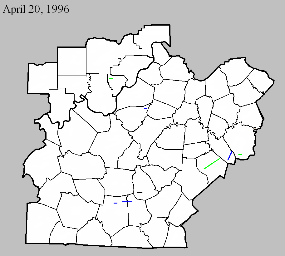
April 20, 1996
Counties: Floyd
F-scale: F2
Deaths:
Injuries:
Path width:
Path length:
Time: 12:08am
Notes: Storm Data mentions damage at the intersection of Georgetown and Greenville roads.
April 20, 1996
Counties: Bullitt
F-scale: F1
Deaths:
Injuries:
Path width:
Path length:
Time: 12:40am
Notes: Storm Data mentions damage in County Trace Estates and on Zoneton Road east of Mount Washington.
April 20, 1996
Counties: Barren
F-scale: F1
Deaths:
Injuries: 4
Path width:
Path length:
Time: 2:30am
Noted discrepancies: None
April 20, 1996
Counties: Barren, Metcalfe
F-scale: F1
Deaths:
Injuries:
Path width:
Path length:
Time: 2:34am
Notes: Storm Data mentions damage at Queens Chapel Church and on KY 314, Spillman Road, and Thurmon-Sexton Road.
April 20 1996
Counties: Green
F-scale: F0
Deaths:
Injuries:
Path width:
Path length:
Time: 2:45am
Notes: Storm Data mentions damage between US 68 and Russell Creek.
April 20, 1996
Counties: Lincoln
F-scale: F2
Deaths:
Injuries: 7
Path width:
Path length:
Time: 3:26am
Notes: Storm Data says this tornado went from near McKinney to Preachersville to near the Garrard County line, damaging the county fairgrounds and Maywood.
April 20, 1996
Counties: Garrard
F-scale: F1
Deaths: 0
Injuries: 0
Path width: 200 yards
Path length: 6 miles
Time: 4:30am to 4:40am EST
Notes: Trees were downed and a dozen barns were destroyed. One farmer lost 6 cows when a barn collapsed on them.
April 20, 1996
Counties: Madison
F-scale: F2
Deaths:
Injuries: 10
Path width:
Path length:
Time: 3:45am
Notes: Storm Data says this tornado touched down on the east side of I-75 at the KY 21 exit. Berea College was damaged.
Current Hazards
Hazardous Weather Outlook
Storm Prediction Center
Submit a Storm Report
Advisory/Warning Criteria
Radar
Fort Knox
Evansville
Fort Campbell
Nashville
Jackson
Wilmington
Latest Forecasts
El Nino and La Nina
Climate Prediction
Central U.S. Weather Stories
1-Stop Winter Forecast
Aviation
IDSS Forecast Points
Air Quality
Fire Weather
Recreation Forecasts
1-Stop Drought
Event Ready
1-Stop Severe Forecast
Past Weather
Climate Graphs
1-Stop Climate
CoCoRaHS
Local Climate Pages
Tornado History
Past Derby/Oaks/Thunder Weather
Football Weather
Local Information
About the NWS
Forecast Discussion
Items of Interest
Spotter Training
Regional Weather Map
Decision Support Page
Text Products
Science and Technology
Outreach
LMK Warning Area
About Our Office
Station History
Hazardous Weather Outlook
Local Climate Page
Tornado Machine Plans
Weather Enterprise Resources
US Dept of Commerce
National Oceanic and Atmospheric Administration
National Weather Service
Louisville, KY
6201 Theiler Lane
Louisville, KY 40229-1476
502-969-8842
Comments? Questions? Please Contact Us.


 Weather Story
 Weather Map
 Local Radar