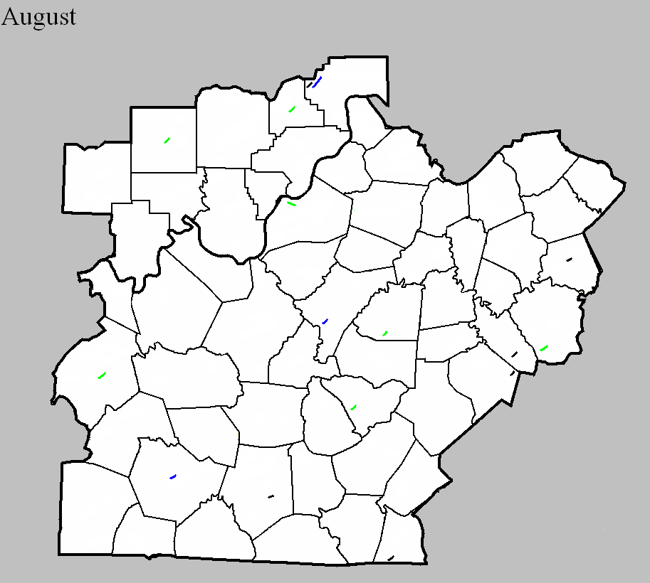
August 27, 1854
Counties: Jefferson KY
F-scale: F2
Deaths: 25
Injuries: 100
Path width: 800 yards
Path length: 2 miles
Time: 12:12pm
Notes: This deadly storm touched down near the intersection of Jefferson and Twentieth Streets, unroofing 21 buildings at the German Protestant Orphan Asylum. The Louisville Daily Courier described the storm as "a whirlwind revolving leftwise." The tornado appears to have travelled in an east-southeasterly direction. Seventeen houses were damaged along Walnut Street from Fifteenth to Seventeenth Streets, a home was severely damaged near the corner of Madison and Thirteenth Streets, and a factory was damaged at the corner of Chestnut and Twelfth Streets. However, the most catastrophic damage occurred when the tornado destroyed the Third Presbyterian Church at Walnut and Eleventh Streets. At a quarter past noon during Sunday services the twister struck the church, causing it to collapse. A door was opened by gusts of wind just moments prior to the tornado, and this may have been one factor in the destruction of the church as powerful tornado winds battered the outside of the building and also were allowed to sweep into the interior of the building. Many women and children were killed, the youngest victim being nine years old. A mother and her three children were discovered grouped in death, and in another spot a father lay dead with the mother mortally wounded, their young child placed beneath them unhurt, protected by the forms of its parents. The toll in the church was about 18 to 20 dead, out of the 55 who were in the church at the time. From the Daily Courier, describing the aftermath of the destroyed church, "Each piercing shriek reveals the fact that some new dead form has been brought to light. Here comes a father borne along by his friends, who take him from his bed of death; next the mother, then the daughter and two sons -- all crushed -- mutilated -- dead!" The church was scheduled to be dedicated the following Sunday. A Mr. Joseph Bradley, while assisting in removing victims from the rubble immediately after the storm, had his eye cut out by a hatchet wielded by a nearby person removing fallen rafters. Mr. Bradley made a full recovery. It was noted in subsequent days that the church was very poorly constructed. People would cross the street rather than walk by it. The Daily Courier noted, "There was scarcely any more cohesiveness in the mortar in the brickwork than if had been made of sand and water." Older, shabbier buildings in the storm were less damaged than the church full of parishioners. Moving on from the church, the tornado tore off rooftops along Tenth, Ninth, and Eighth Streets between Chestnut Street and Broadway. A new frame home was destroyed on Sixth Street just south of Broadway, and chimney and other miscellaneous damage occurred along Broadway between Fifth and Fourth Streets as the tornado began to dissipate. The final damage was that of an unroofed house at the corner of Breckenridge and Fifth Streets. It was the worst disaster seen in Louisville up to that time. At least a hundred buildings were affected. Mayor James Speed ordered all businesses in the city closed the next day.
Side note: Interestingly, in researching this event, we found two distinct paths of destruction across Louisville (see map). The path described above was more certainly a tornado. The other path was parallel to the tornado and about half a mile to the north, on the west edge of downtown. Significant destruction was done on Main Street between Ninth and Eighth Streets where two of the "best and most substantial business houses in the city were scattered as though they had been made of cards," with the walls collapsing inward. A factory was damaged on Main Street just west of Ninth Street, in the Tobacco District. Boats in the Ohio River were blown loose of their moorings and landed on the falls. Many boats were damaged and some were totally destroyed, including a steamboat. Four houses were even blown down across the river in Jeffersonville. Significant damage continued until the intersection of Main and Sixth Streets. Beyond that, slight damage was done to the Walnut Street Baptist Church (corner of Fourth Street and Muhammad Ali Boulevard), and worshippers participating in Mass at the cathedral on Fifth Street were blown off their feet. It has been decided, to the best of our ability, that these events were due to straight-line winds. Also, the storm brought extremely heavy rain that caused Beargrass Creek to flood, but the rains were generally welcome as the region had been suffering through a severe drought.
August 1, 1954
Counties: Orange
F-scale: F2
Deaths:
Injuries:
Path width:
Path length:
Time: Noon
Noted discrepancies: SPC and NCDC list this as an F2, Grazulis does not list it. SPC gives a path length of 1/10 of a mile, NCDC gives nothing. SPC gives a path width of 10 yards, NCDC gives nothing.
August 2, 1954
Counties: Washington KY
F-scale: F2
Deaths: 0
Injuries: 0
Path width:
Path length:
Time: 3:00pm
Grazulis Narrative: Three barns and a small school were destroyed two miles south of Springfield. One home was unroofed.
Noted discrepancies: SPC and Storm Data list both Taylor and Washington counties...NCDC lists only Taylor County...Grazulis lists only Washington County. SPC's and Storm Data's "Taylor and Washington" counties makes no sense since those two counties don't border each other. SPC/NCDC's lat/lon pairs start this tornado in Taylor County and end it in Washington County, crossing the entire width of Marion County in between. SPC and NCDC give a path length of 15 miles, Grazulis and Storm Data give 1 1/2 miles. SPC gives a path width of 10 yards...NCDC 30 yards...Grazulis and Storm Data 100 yards. Apparently the only tornado damage Grazulis could find with this event was two miles south of Springfield near the Washington/Marion County line (which is where SPC and NCDC have the tornado track's end point). Storm Data narrative says, "Tornado first appeared near Finley in Taylor County, completely missed Marion County, and came to earth again in Washington County a short distance south of Springfield." The distance across Marion County is about 14 miles. Thus, it seems this should be plotted as two separate tornadoes...with one in Taylor County near Finely and the other in Washington County near Springfield. However, before plotting the Taylor County tornado, an F-scale must be investigated.
August 13, 1966
Counties: Ohio
F-scale: F2
Deaths:
Injuries:
Path width:
Path length:
Time: 5:25pm
Noted discrepancies: SPC/NCDC call this an F2...Grazulis does not list it.
Notes: Storm Data says this tornado touched down one and a half miles northeast of Hartford and moved northeast for a mile and a half.
August 9, 1968
Counties: Scott IN
F-scale: F2
Deaths: 0
Injuries: 0
Path width:
Path length:
Time: 2:00pm
Grazulis narrative: A barn was destroyed near Scottsburg. Minimal F2.
Noted discrepancies: SPC gives a path length of 1/10 of a mile and a width of 10 yards...NCDC gives nothing for either.
August 19, 1972
Counties: Madison
F-scale: F2
Deaths:
Injuries: 1
Path width:
Path length:
Time: 2:00pm
Noted discrepancies: NWS lists this as an F2, Grazulis does not list it. SPC gives a path length of 1/10 of a mile and a path width of 10 yards...NCDC gives nothing for either.
August 25, 1972
Counties: Nelson
F-scale: F1
Deaths:
Injuries:
Path width:
Path length:
Time: 1:50pm
Noted discrepancies: SPC gives a path width of 10 yards, NCDC gives 30 yards. This tornado is not listed in Storm Data! More research would be helpful.
August 1, 1979
Counties: Jefferson IN
F-scale: F0
Deaths:
Injuries:
Path width:
Path length:
Time: 10:25am
Notes: Storm Data has this tornado touch down near Paris.
August 5, 1981
Counties: Taylor
F-scale: F2
Deaths:
Injuries: 1
Path width:
Path length:
Time: 9:00pm
Noted discrepancies: NWS ranks this as an F2, Grazulis does not list it.
August 11, 1983
Counties: Warren
F-scale: F1
Deaths:
Injuries: 6
Path width:
Path length:
Time: 2:00pm
Notes: Storm Data says this tornado struck the Greenwood Trailer Park on the north side of Bowling Green.
August 11, 1983
Counties: Clark KY
F-scale: F0
Deaths:
Injuries:
Path width:
Path length:
Time: 2:50pm
Noted discrepancies: Storm Data says this storm struck on Irvine Road. Mapped as best as possible, since lat/lon given was just off of Irvine Road. In appears to have struck in or very near Winchester, so additional research may help to pinpoint its exact location.
August 12, 1983
Counties: Garrard
F-scale: F0
Deaths:
Injuries:
Path width:
Path length:
Time: 8:00pm
Notes: Storm Data says this tornado struck on Gaffney Road. Plotted on Gaffney Road as close to the given lat/lon as possible.
August 9, 1987
Counties: Clinton
F-scale: F0
Deaths:
Injuries:
Path width:
Path length:
Time: 7:23pm
Notes: Storm Data says this tornado touched down just south of Shipley.
August 19, 1999
Counties: Lincoln
F-scale: F0
Deaths:
Injuries:
Path width:
Path length:
Time: 2:00pm
Notes: Storm Data puts this tornado two miles north of Crab Orchard.
August 14, 2002
Counties: Jefferson IN
F-scale: F1
Deaths:
Injuries:
Path width: 125 yards
Path length: 4 miles
Time: 12:52pm
Noted discrepancies: SPC lists a path width of 40 yards, NCDC lists 123 yards, Storm Data says 125 yards.
Notes: Storm Data takes this tornado from 1/10 of a mile southwest of Deputy to 3.9 miles northeast of Deputy.
August 20, 2016
County: Barren
EF-Scale: EF0
Deaths: 0
Injuries: 0
Path width: 30 yards
Path length: 1.5 miles
Time: 5:30pm - 5:33pm CDT
Notes: The tornado touched down in a corn field near Morrison Park Road, just east of Tompkinsville Road. The tornado moved east-northeast, roughly paralleling Morrison Park Road, flattening corn on several farms. Structural damage was observed on one farm, where the roof was torn off a large metal outbuilding and minor damage occurred to several other buildings as a result of this debris. Several trees were snapped or uprooted before the tornado lifted just east of Highway 90.


 Weather Story
 Weather Map
 Local Radar
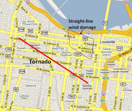