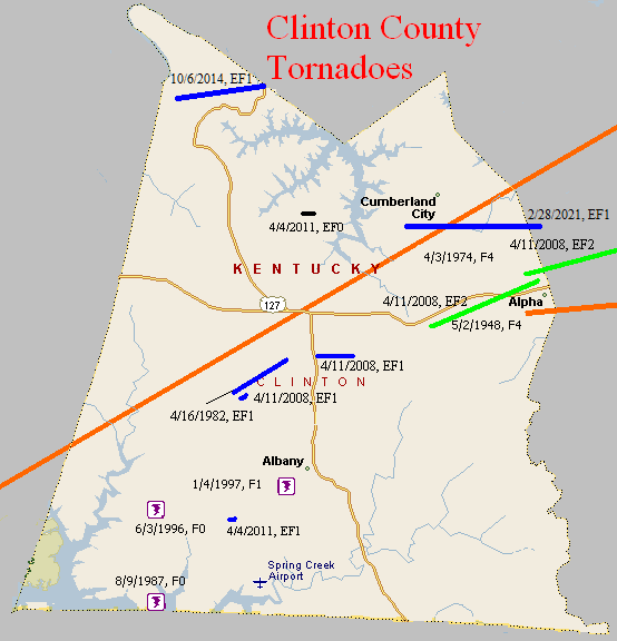
May 2, 1948
Counties: Clinton (to Wayne)
F-scale: F4
Deaths: 5
Injuries: 60
Path width: 300 yards
Path length: 10 miles
Time: 7:00pm
Grazulis narrative: Moved east-northeast, leveling homes near Alpha, Sumter, and Copper. Three people were killed in a home near Alpha and two in a home near Sumter. Most of the injuries were in a church that was torn apart and collapsed during evening services.
April 3, 1974
Counties: Cumberland, Clinton (to Wayne)
F-scale: F4
Deaths:
Injuries: 96
Path width: 800 yards
Path length:
Time: 5:40pm
Grazulis narrative: Moved northeast from two miles south of Kettle, to Ida, eight miles northwest of Albany, to 76-Falls, to Piney Woods, and finally to Mill Springs. Eight people were killed in five different small Clinton County communities as 50 homes were damaged or destroyed.
Noted discrepancies: Grazulis and Storm Data list this tornado at 6:40pm...SPC and NCDC say 5:40pm. This time disagreement may have something to do with the tornado being near a time zone boundary. SPC and NCDC list 8 fatalities, Grazulis and Storm Data list 10. Storm Data and NCDC list 113 injuries, Grazulis 96. SPC gives a path length of 38 miles...NCDC says 39 miles...Grazulis 30 miles...Storm Data 35 miles. SPC gives a path width of 10 yards, NCDC gives 30 yards, Storm Data 587 yards, Grazulis 800 yards. Grazulis probably has the more correct path width. There were two F4's in Wayne County on this day, so that may be adding to some of the confusion, especially with the injury numbers.
Notes: Storm Data lists this as "twin tornadoes" from two miles south of Kettle to Ida to 76-falls to Piney Woods to Mill Springs. Will go ahead and list 96 injuries for this tornado since that number is known for Cumberland and Clinton counties, and Wayne County is not in this project's area of concern.
Special note: Did Fujita's tornado #82 clip the southeast tip of Clinton County on April 3, 1974? So far, it doesn't look like it...
April 16, 1982
Counties: Clinton
F-scale: F1
Deaths:
Injuries:
Path width:
Path length:
Time: 7:00pm
Notes: Storm Data begins this tornado at Browns Crossroads and takes it northeast for two miles.
August 9, 1987
Counties: Clinton
F-scale: F0
Deaths:
Injuries:
Path width:
Path length:
Time: 7:23pm
Notes: Storm Data says this tornado touched down just south of Shipley.
June 3, 1996
Counties: Clinton
F-scale: F0
Deaths:
Injuries:
Path width:
Path length:
Time: 8:10pm
Notes: Storm Data puts this tornado at Shipley.
January 4, 1997
Counties: Clinton
F-scale: F1
Deaths: 1
Injuries: 2
Path width:
Path length:
Time: 10:55pm
Notes: Storm Data mentions damage on KY 1590 half a mile west of Albany.
April 20, 2000
Counties: Clinton
F-scale: F0
Deaths:
Injuries:
Path width:
Path length:
Time: 6:00pm
Noted discrepancies: SPC gives a path width of 20 yards, NCDC says 27 yards, Storm Data says 25 yards. The lat/lon for this tornado at SPC is in Tennessee. The NCDC begin location and end location (8 miles southwest of Albany) also places this tornado in Tennessee, or, depending on the degree of "southwest", in the middle of Dale Hollow Lake. Narrative at NCDC gives no additional location information. Storm Data also plots this tornado "8 miles southwest of Albany" and mere mentions that "a piece of scaffolding and a cement mixer pan were moved 50 yards at Ootens Store." Further research is necessary.
April 11, 2008
Counties: Clinton
EF-scale: EF1
Deaths: 0
Injuries: 0
Path width: 150 yards
Path length: 0.4 miles
Time: 11:39am CST to 11:40am CST
Notes: Touchdown was west of KY 639 south of Wago. The tornado destroyed a barn and brick silo along KY 639, and downed several trees. Trees were felled onto a farmhouse and a SUV just north of the silo, destroying the SUV and doing extensive damage to the home. Minor damage was sustained east of KY 639 to several outbuildings.
April 11, 2008
Counties: Clinton
EF-scale: EF1
Deaths: 0
Injuries: 0
Path width: 150 yards
Path length: 0.5 miles
Time: 11:41am CST to 11:42am CST
Notes: Four utility poles were snapped along US 127 near Snow, as were several large diameter trees in a narrow path on a wooded hill to the east of the highway.
April 11, 2008
Counties: Clinton
EF-scale: EF2
Deaths: 0
Injuries: 0
Path width: 300 yards
Path length: 3.1 miles
Time: 11:44am CST to 11:47am CST
Notes: Several homes and outbuildings were damaged between Cartwright and Narvel. Scores of trees were downed, along with power lines. A witness at the end of this tornado's path reported seeing two tornadoes on the ground simultaneously, as the fourth tornado produced by this supercell touched down about a quarter mile north of the ending point of this one.
April 11, 2008
Counties: Clinton
EF-scale: EF2
Deaths: 0
Injuries: 0
Path width: 300 yards
Path length: 1.4 miles
Time: 11:46am CST to 11:50am CST
Notes: This tornado hit several residences in a rural subdivision along Pleasure Ridge Road. After moving through uninhabited hillside for a mile, uprooting and snapping trees in a near quarter mile wide path, the tornado tore off the roof of a ranch-style brick home and destroyed its nearby outbuildings. Continuing along and parallel to Pleasure Ridge Road, the tornado destroyed a mobile home and barn in its path, and heavily damaged at least three other homes before exiting the county.
April 4, 2011
Counties: Clinton
F-scale: EF1
Deaths: 0
Injuries: 0
Path width: 100 yards
Path length: 0.20 mile
Time: 3:14pm CDT
Notes: A short-lived tornado with winds to 90 mph touched down 4.25 miles southwest of Albany. A large boat storage barn, 125 x 30 feet, had its roof lifted and thrown approximately 90 yards. A second storage shed was also destroyed. A house along the path had a window blown out and the metal roof peeled back. Multiple trees were uprooted as well. On either side of the tornado track straight-line wind damage extended out 100 yards with limbs and trees blown down. The straight-line winds were estimated at 70 mph.
April 4, 2011
Counties: Clinton
F-scale: EF0
Deaths: 0
Injuries: 0
Path width: 60 yards
Path length: 0.14 mile
Time: 3:16pm CDT
Notes: A tornado with winds to 85 mph struck about three-quarters of a mile north-northeast of Seventy-Six. Multiple pine, ash, and oak trees were snapped and uprooted.
October 6, 2014
County: Clinton
EF-Scale: EF1
Deaths: 0
Injuries: 0
Path width: 150 yards
Path length: 2.3 miles
Time: 6:13pm - 6:17pm CDT
Notes: This tornado struck about 11 miles NNW of Albany in the northwest tip of Clinton County. Numerous trees were snapped or uprooted. The only non-tree damage was to power poles along US 127. A couple in a vehicle on US 127 was trapped when trees fell across the highway both north and south of them.
February 28, 2021
County: Clinton (to Wayne)
EF-Scale: EF1
Deaths: 0
Injuries: 0
Path width: 75 yards
Path length: 3.6 miles
Time: 8:18-8:22pm CST
Notes: The initial touchdown was on the western edge of Cumberland City. There were several snapped trees along with roofing damage at several homes before more extensive structural damage occurred at 5250 KY 558. Several large barns were destroyed or had at least 70% of the walls blown out. A one month old 64'x56' barn with 6' footers in concrete was destroyed. The debris from the barn was thrown over a quarter mile to the northeast. A 60'x43' barn that had been recently remodeled and upgraded had three walls blown out. A Kubota UTV weighing 2500 pounds was moved 30 yards and rotated 180 degrees. There was also extensive snapping and uprooting of trees. Winds were estimated at 110 mph. Further east, a large 50'x60' barn was destroyed and debris went at least half a mile downwind. A mobile home on KY 829 was lifted off its foundation and there were several trees uprooted and snapped. The tornado crossed KY 829 and then crossed KY 1009 with extensive tree damage along both sides of the road. A large barn on KY 1009 had two walls blown out with debris thrown over half a mile downwind into Wayne County. The tornado dissipated about half a mile into Wayne County.


 Weather Story
 Weather Map
 Local Radar