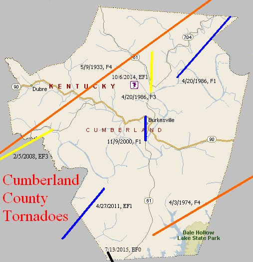
May 9, 1933
Counties: Monroe, Cumberland, Adair, Russell
F-scale: F4
Deaths: 36
Injuries: 87
Path width: 800 yards
Path length: 60 miles (probably a family of tornadoes)
Time: 8:30pm
Notes: This historic event began around 8pm when there was 30 minutes of rain and hail in Tompkinsville, followed by five minutes of absolute calm. The calm was shattered when a tornado touched down just southwest of town and moved northeast, directly into southern sections the city (the "Negro section," as newspapers called it at the time). The path of utter destruction, in which everything was flattened, was a quarter mile wide. The damaged residences of O. C. Landrum and Oscar Sims marked the edges of the devastation. Between them was a treeless and fenceless waste, with scattered remnants of homes and uprooted trees. A heavy rain, which fell continuously from 1 o'clock until 6 the following morning, made roads almost impassable and handicapped the work of rehabilitation. Only three homes that were affected by the funnel were able to be salvaged. World War I veterans described the devastation and suffering as worse than what they witnessed during the Great War. The twisting nature of the winds was clearly revealed when the bodies of the Tyree family were found 75 yards south of their home site, and the bodies of the Redeford family were discovered 100 yards north of the spot where their home had stood. The Tyrees lived on the southern edge of the storm area, while the Redefords lived near the northern edge. The body of the Rev. Redeford's wife was carried 150 yards to a pond on the land belonging to L. P. Hagan. The corpse of the husband was found entangled in a barbed wire fence, having been blown about one hundred yards. Sixteen people in Tompkinsville lost their lives that evening, with another 2 deaths just northeast of town in Sewell. Fifty citizens were injured in Monroe County. After Tompkinsville, the tornado continued to the northeast, crossing Cumberland County (2 people injured) and clipping the southeast corner of Adair County (2 people killed in the Cundiff area) with comparatively little damage, before intensifying again as it entered Russell County. The tornado grew into a mile-wide monster as it plowed down at least 100 homes. The edge of the tornado missed downtown Russell Springs by only half a mile. The tornado spent its last fury in the Happy Acre area, causing damage along Goose Creek, near Friendship Church, and on the southern end of Bethany Ridge where chickens were stripped of their feathers. The tornado lifted at the Casey County line. Fatality counts for Russell County vary from 14 to 20 depending on the source...this study will use Grazulis' number of 18. Of those 18, 14 were killed on the southeast edge of Russell Springs. Up to 100 people may have been injured in Russell County.
April 3, 1974
Counties: Cumberland, Clinton (to Wayne)
F-scale: F4
Deaths:
Injuries: 96
Path width: 800 yards
Path length:
Time: 5:40pm
Grazulis narrative: Moved northeast from two miles south of Kettle, to Ida, eight miles northwest of Albany, to 76-Falls, to Piney Woods, and finally to Mill Springs. Eight people were killed in five different small Clinton County communities as 50 homes were damaged or destroyed.
Noted discrepancies: Grazulis and Storm Data list this tornado at 6:40pm...SPC and NCDC say 5:40pm. This time disagreement may have something to do with the tornado being near a time zone boundary. SPC and NCDC list 8 fatalities, Grazulis and Storm Data list 10. Storm Data and NCDC list 113 injuries, Grazulis 96. SPC gives a path length of 38 miles...NCDC says 39 miles...Grazulis 30 miles...Storm Data 35 miles. SPC gives a path width of 10 yards, NCDC gives 30 yards, Storm Data 587 yards, Grazulis 800 yards. Grazulis probably has the more correct path width. There were two F4's in Wayne County on this day, so that may be adding to some of the confusion, especially with the injury numbers.
Notes: Storm Data lists this as "twin tornadoes" from two miles south of Kettle to Ida to 76-falls to Piney Woods to Mill Springs. Will go ahead and list 96 injuries for this tornado since that number is known for Cumberland and Clinton counties, and Wayne County is not in this project's area of concern.
April 20, 1986
Counties: Cumberland
F-scale: F3
Deaths: 0
Injuries: 2
Path width:
Path length: 3 miles
Time: 4:45pm
Grazulis narrative: Two farms were struck, and one was completely destroyed three miles north of Burkesville. A couple was hurt in their destroyed homes. The woman was badly cut by glass, and her husband was caught between fireplace bricks and a collapsed wall. The roof of the house was set down three miles away. A barn "exploded", killing thirty chickens. A satellite dish was blown about a mile. Large pieces of tin roofing were twisted around trees and wadded up into balls.
Noted discrepancies: SPC and NCDC list a path width of 400 yards, Grazulis says 100 yards. Grazulis lists this storm at 5:45pm.
April 20, 1986
Counties: Cumberland
F-scale: F1
Deaths:
Injuries:
Path width:
Path length:
Time: 5:10pm
Notes: Storm Data says this tornado struck Bakerton (touching down on the southwest side of town) and lifted at the Adair County line after following Little Renox Creek.
November 9, 2000
Counties: Cumberland
F-scale: F1
Deaths:
Injuries:
Path width:
Path length:
Time: 1:40pm
Noted discrepancies: SPC lists a path width of 70 yards, NCDC 73 yards, Storm Data 75 yards.
Notes: Storm Data takes this tornado from one mile southwest of Burkesville to one mile northwest of Burkesville.
February 5, 2008
Counties: Monroe, Cumberland (from Sumner, TN)
EF-scale: EF3
Deaths: 0
Injuries: 0
Path width: 440 yards
Path length: 21.2 miles
Time: 10:31pm CST to 10:50pm CST
Notes: About two miles west of Gamaliel the tornado destroyed two conventional homes and two mobile homes. Thirteen residents of the four homes took shelter in the basement of one of the homes. They escaped without injury, though they were trapped in rubble for 30 minutes. Several other homes were damaged in a subdivision one mile north of Gamaliel. The tornado ripped the roof off of a brick home there. It then tracked across rural Monroe County, uprooting and snapping large trees. On the north side of Tompkinsville it destroyed a large wood frame warehouse and twisted a large steel frame metal building off its foundation. A nearby well-built brick home had its roof and exterior walls swept away. It also destroyed a detached three car garage. The tornado then proceeded through a rural area of Cumberland County and lifted about three miles southwest of Marrowbone.
April 27, 2011
Counties: Monroe, Cumberland
EF-Scale: EF-1
Deaths: 0
Injuries: 0
Path width: 616 yards
Path length: 6 miles
Time: 7:02am CDT
Notes: Two large barns and several outbuildings were destroyed. Hundreds of hardwood trees were snapped and uprooted, with a few trees landing on houses causing roof damage. A few other houses in the vicinity had minor structural damage as well.
October 6, 2014
County: Cumberland
EF-Scale: EF1
Deaths: 0
Injuries: 0
Path width: 100 yards
Path length: 0.2 mile
Time: 6:02pm CDT
Notes: Two hundred trees were uprooted on a ridge top near the end of Dug Road north of Burkesville.
July 13, 2015
County: Cumberland
EF-Scale: EF0
Deaths: 0
Injuries: 0
Path width: 100 yards
Path length: 0.7 mile
Time: 6:13pm - 6:15pm CDT
Notes: This small tornado destoryed one outbuilding and tore roof panels off another before crossing the state line into the Pearidge area of Tennessee just west of Dale Hollow Lake.


 Weather Story
 Weather Map
 Local Radar