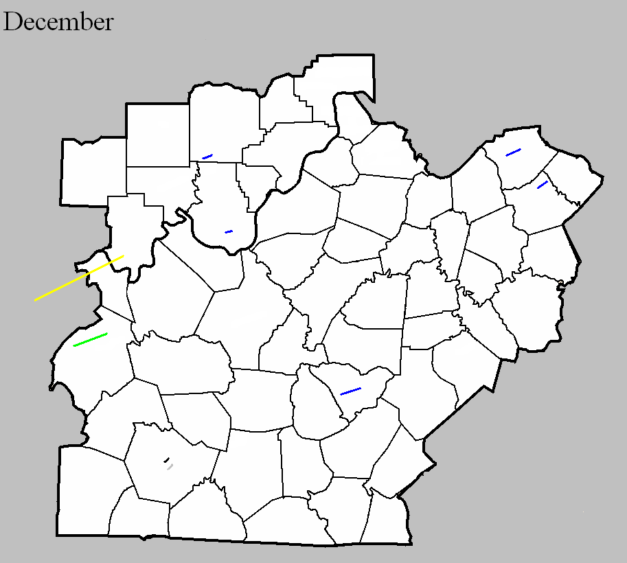
December 29, 1865
Counties: Warren
F-scale:
Deaths:
Injuries:
Path width:
Path length:
Time:
Narrative: A tornado unroofed and blew out the walls of a bank in Bowling Green.
December 4, 1916
Counties: Ohio
F-scale: F2
Deaths: 0
Injuries: 0
Path width: 100 yards
Path length: 10 miles
Time: 3:30pm
Narrative: Moved east-northeast seven miles north of Hartford. This tornado "bounced like a rubber ball" and destroyed several homes.
December 9, 1952
Counties: Hancock, Perry (from Daviess)
F-scale: F3
Deaths: 0
Injuries: 3
Path width: 880 yards
Path length: 32 miles
Time: 3:00pm
Grazulis Narrative: Moved northeast, striking the northern part of Tell City. There were three homes destroyed in Kentucky, and $200,000 damage. Many barns were destroyed in Indiana, where there was $300,000 damage. Most of the Indiana damage was from wind-driven hail.
Noted discrepancies: SPC and NCDC call this an F3, Grazulis an F2. SPC and NCDC give a time of 3:00pm, Grazulis 2:30pm. SPC gives a path length of 70 miles, NCDC gives 35 miles, Grazulis gives 32 miles. SPC gives a path width of 880 yards, NCDC gives 30 yards, Grazulis says 400 yards. Grazulis mentions this was probably a family of tornadoes. NCDC or Grazulis must have the better path length...SPC entry looks to be an entry error. Storm Data says the tornado crossed from Kentucky into Indiana at Tell City with a "total path length in both states" of 32 miles.
December 11, 1967
Counties: Washington IN
F-scale: F1
Deaths:
Injuries:
Path width:
Path length:
Time: 1:30pm
Noted discrepancies: SPC gives a path width of 10 yards...NCDC 30 yards.
December 15, 1971
Counties: Warren
F-scale: F0
Deaths:
Injuries:
Path width:
Path length:
Time: 8:30am
Noted discrepancies: Storm Data says this tornado touched down at Beech Bend Park four miles northwest of Bowling Green...should say northeast.
December 21, 2013
County: Taylor
EF-Scale: EF1
Deaths: 0
Injuries: 0
Path width: 300 yards
Path length: 6 miles
Time: 11:07pm - 11:13pm EST
Notes: This tornado touched down along Old Greensburg Road just west of the intersection of US 68 and KY 323, where it immediately destroyed small outbuildings. The tornado entered the city of Campbellsville when it crossed KY 210 and uprooted trees and damaged buildings near the intersection of Hodgenville Road and Vintage Lane. A more concentrated area of damage then occurred as the tornado crossed Saloma Road and moved roughly parallel to and just north of Upper Miller Park Road. Trees were torn down and rooftops damaged in this area. The tornado exited the city at the intersection of Eastern Drive and East Lake Drive. The final damage occurred at the intersection of US 68 and Palestine Road. At this location there was more tree and roof damage.
December 21, 2013
County: Harrison KY
EF-Scale: EF1
Deaths: 0
Injuries: 0
Path width:110 yards
Path length: 3.8 miles
Time: 11:29pm - 11:34pm EST
Notes: The NWS storm survey team found many areas of intermittent straight line wind damage around northern Harrison County, with one specific tornado path. There were many barns damaged or destroyed, power lines and power poles down or snapped, some trees snapped and uprooted, and several homes and outbuildings had roof damage. The most concentrated damage was along Dutch Chapel Road where about half a dozen large barns, garages, and outbuildings were either destroyed or sustained significant damage. In addition, two homes on Dutch Chapel Road had significant roof damage and other structural damage, with debris thrown to the north, northeast, and east southeast. Several residents on Dutch Chapel Road heard a distinct "freight train roar" and their ears popped, along with zero visibility during torrential rain when the storm struck.
December 21, 2013
County: Bourbon
EF-Scale: EF1
Deaths: 0
Injuries: 0
Path width: 125 yards
Path length: 4.8 miles
Time: 11:41pm - 11:45pm EST
Notes: The NWS storm survey team found many areas of straight line wind damage across northern Bourbon County, and one specific tornado path within the straight line wind damage. There were many barns damaged or destroyed, power lines and poles down or snapped, and many softwood and hardwood trees snapped, twisted, and uprooted. Several homes and outbuildings had roof damage. The most concentrated damage was along Colville Road, down Endicott Lane, and over to the Steele Ford Road area. In this area, several large barns, garages, and outbuildings were either destroyed or sustained significant damage, with debris thrown to the north, northeast, and east. In addition, some well anchored solid footers from a garage and barn at 201 Endicott Lane were lifted up and thrown 75 yards. Several residents reported a loud roar, their ears popped, and there was zero visibility in torrential rain when the storm struck.
December 31, 2018
County: Harrison IN
EF-Scale: EF1
Deaths: 0
Injuries: 0
Path width: 140 yards
Path length: 2.2 miles
Time: 3:38pm - 3:41pm EST
Notes: This was an intermittent skipping tornado. A maximum wind speed of 100 mph wind was found. The tornado initially touched down at 7231 IN 337. At this location a heavy metal chain fence weighing several hundred pounds was picked up and thrown 30 yards into the back of the house causing significant damage. A chicken house weighing hundreds of pounds was rolled over and moved several feet. A purple martin house was bent over 60 degrees facing east. Shingles and yard decorations were thrown in various directions east of the house along with driveway gravel thrown in every direction. A swing set was thrown from the back of the house to the front. Throughout the property there were twisted and uprooted trees. Just before crossing the highway, the tornado increased from 75 yards to 140 yards and picked up hundreds of cornstalks tossing them in various directions across the road up to 300 yards away. Across the street at 7768 IN 337 there was significant cedar tree damage along with a 30 by 40 foot barn that was destroyed. The tornado twisted and snapped several cedar trees before going across the farmers field. The tornado narrowed and went to about 50 yards in width. At 4368 Rogers Campground Road there were several trees twisted and snapped. One single wide mobile home had siding panels blown out in several spots. An older, well built barn with sturdy cedar poles sustained significant side panel damage. The metal sheeting was thrown in a northwesterly to northeasterly direction. One 2x4 wood pole was embedded in the ground. The tornado was very narrow along Rogers Campground Road, likely no more than 50 yards wide.


 Weather Story
 Weather Map
 Local Radar