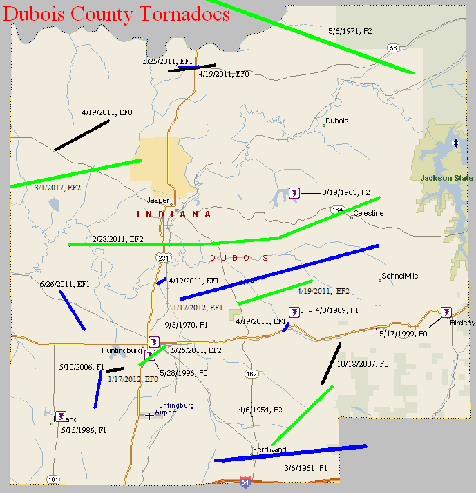
April 6, 1954
Counties: Dubois
F-scale: F2
Deaths:
Injuries:
Path width: 30 yards
Path length:
Time: 7:00am
Noted discrepancies: SPC and NCDC list this as an F2, Grazulis does not list it. SPC gives a path width of 10 yards, NCDC gives 30 yards.
March 6, 1961
Counties: Dubois
F-scale: F1
Deaths:
Injuries:
Path width:
Path length:
Time: 8:00am
Noted discrepancies: SPC gives a path width of 10 yards, NCDC 30 yards. Storm Data says this tornado moved from southwest of Ferdinand to Siberia (Siberia proper is actually in Perry County, just over the county line). The ending lat/lon given is just inside Perry County as well. Will map as such, but further research would be helpful.
March 19, 1963
Counties: Dubois
F-scale: F2
Deaths:
Injuries:
Path width:
Path length:
Time: 2:00pm
Noted discrepancies: SPC and NCDC rank this as an F2, but Grazulis does not list it. SPC gives a path length of 1/10 of a mile and a path width of 10 yards...NCDC gives nothing for either.
October 24, 1967
Counties: Dubois
F-scale: F3
Deaths:
Injuries:
Path width:
Path length:
Time: 3:45pm
Noted discrepancies: SPC and NCDC list this as an F3, Grazulis does not list it. SPC gives a path length of 1/10 of a mile and a width of 10 yards...NCDC gives nothing for either.
Notes: Hard to believe and F3 tornado with a path length and width as small as what SPC gives. Also hard to believe the NWS would give it an F3 rating and Grazulis would only give it an F1 or less. Something odd here. The only damage described in Storm Data done directly by the tornado is the destruction of a concrete poultry house south of Dubois on IN 162 (which also sounds weird since IN 162 is not in close proximity to Dubois and is nowhere near the lat/lon given by SPC/NCDC). Additional research necessary!
September 3, 1970
Counties: Dubois
F-scale: F1
Deaths:
Injuries:
Path width:
Path length:
Time: 2:09pm
Noted discrepancies: None
May 6, 1971
Counties: Dubois (from Knox, Daviess, and Martin)
F-scale: F2
Deaths: 0
Injuries:
Path width: 50 yards
Path length: 25 miles (skipping)
Time: 9:20am
Grazulis narrative: Skipped east-southeast from east of Vincennes, passing near Hudsonville, Cumback, and Glendale. A rural school was destroyed, as was a large church and several barns. The injuries were in trailers.
Noted discrepancies: NCDC and Grazulis only list Knox and Daviess counties. The end lat/lon listed at NCDC under the Daviess County entry is actually the end lat/lon given by SPC, in Dubois County. SPC and NCDC give a time of 9:20am, Grazulis has 10:30am, and Storm Data says 10:07am. SPC and NCDC list one injury, Grazulis lists four. According to Storm Data the tornado touched down six miles south of Lawrenceville, Illinois, and then moved on to the northern and eastern edges of Vincennes, then to eleven miles southeast of Vincennes, Glendale, Monroe City, Cumback, Hudsonville, Hayesville (Dubois County), and the tornado lifted at the Purdue Research Farm near Cuzco (Dubois County).
May 15, 1986
Counties: Dubois
F-scale: F1
Deaths:
Injuries:
Path width:
Path length:
Time: 5:30pm
Notes: Storm Data puts this tornado at Holland.
May 28, 1996
Counties: Dubois
F-scale: F0
Deaths:
Injuries:
Path width:
Path length:
Time: 4:40pm
Notes: Storm Data says this tornado struck the south side of Huntingburg.
May 17, 1999
Counties: Dubois
F-scale: F0
Deaths:
Injuries:
Path width:
Path length:
Time: 5:20pm
Notes: Storm Data puts this tornado in Birdseye.
May 10, 2006
Counties: Dubois
F-scale: F1
Deaths: 0
Injuries: 0
Path width: 100 yards
Path length: 1.4 miles
Time: 5:49pm Central
Notes: One home received major roof damage. A workshop containing tools and heavy equipment was destroyed. Other homes received minor damage, and some outbuildings and carports were damaged. Several trees were uprooted.
October 18, 2007
Counties: Dubois
EF-scale: EF0
Deaths: 0
Injuries: 0
Path width: 125 yards
Path length: 2 miles
Time: 9:27pm EDT to 9:30pm EDT
Notes: The door of a house was blown out about four miles northeast of Ferdinand, near the start of the tornado path. A barn was damaged about a half mile
south of Kyana, near the end of the damage path. Over 100 large oak trees were snapped off or uprooted in the Ferdinand Forest.
February 28, 2011
Counties: Dubois
F-scale: EF2
Deaths: 0
Injuries: 1
Path width: 225 yards
Path length: 15.7 miles (skipping)
Time: 3:19am EST
Notes: The tornado first touched down just north of Duff east of County Road 650W. Damage to several large metal buildings, a large barn, and a radio tower were observed south of Jasper. After a brief break in the path, the tornado touched down again four miles southwest of Celestine and took a slight turn to the northeast. The most significant damage along this segment was in Celestine near Ellsworth Road. Damage included roofs blown off two brick homes with the walls collapsed in one home. In addition a double-wide trailer was blown off its foundation and an RV was tossed across the road.
April 19, 2011
Counties: Dubois
EF-scale: EF1
Deaths: 0
Injuries: 0
Path width: 200 yards
Path length: 3.1 miles
Time: 11:22pm EDT
Notes: A well constructed 75-foot tall grain silo had the top 40 foot portion sheared off north of Ireland. A 40 ft by 50 ft outbuilding was destroyed in the vicinity of the grain silo, with siding thrown up to 500 yards downwind.
April 19, 2011
Counties: Dubois
EF-Scale: EF0
Deaths: 0
Injuries: 0
Path width: 200 yards
Path length: 0.3 mile
Time: 11:22pm EDT
Notes: A large swath of hardwood trees were snapped or uprooted three miles north of Huntingburg.
April 19, 2011
Counties: Dubois
EF-Scale: EF-0
Deaths: 0
Injuries: 0
Path width: 200 yards
Path length: 2 miles
Time: 11:25pm EDT
Notes: At the beginning point of this tornado a few small trees, some dead, were blown over and branches were blown off of some of the trees. Several trees were blown over in Haysville. The most intense damage occurred as the tornado lifted east of Haysville in the woods along IN 56. At that point several trees up to two feet in diameter were blown down.
April 19, 2011
Counties: Dubois
EF-Scale: EF-2
Deaths: 0
Injuries: 0
Path width: 300 yards
Path length: 3.3 miles
Time: 11:26pm EDT
Notes: A large number of trees were snapped and uprooted north of Bretzville and Saint Anthony. Several barns and outbuildings were destroyed.
April 19, 2011
Counties: Dubois
EF-Scale: EF-1
Deaths: 0
Injuries: 0
Path width: 100 yards
Path length: 0.4 mile
Time: 11:26pm EDT
Notes: Hardwood trees were snapped and uprooted southwest of Saint Anthony. A residence north of Indiana 64 was damaged.
May 25, 2011
Counties: Dubois
EF-Scale: EF-2
Deaths: 0
Injuries: 0
Path width: 100 yards
Path length: 2 miles
Time: 9:50pm EDT
Notes: This tornado struck the southeast side of Huntingburg.
May 25, 2011
Counties: Dubois
EF-Scale: EF-1
Deaths: 0
Injuries: 0
Path width: 60 yards
Path length: 1.9 miles
Time: 9:54pm EDT
Notes: The tornado destroyed a shed when it touched down along North CR 200W west of Haysville. It snapped trees as it moved east into Haysville. One home was unroofed, at the corner of North Church Street and West Haysville Road.
June 26, 2011
Counties: Dubois
EF-Scale: EF-1
Deaths: 0
Injuries: 0
Path width: 130 yards
Path length: 2.2 mile
Time: 2:54am EDT
Notes: In the Duff area several homes suffered minor damage and numerous trees, both softwood and hardwood, were snapped or uprooted.
January 17, 2012
County: Dubois
EF-Scale: EF0
Deaths: 0
Injuries: 0
Path width: 25 yards
Path length: 0.1 mile
Time: 9:44am EST
Notes: Touched down 2.7 miles southwest of Huntingburg. An outbuilding was destroyed and debris was scattered for a quarter mile.
January 17, 2012
County: Dubois
EF-Scale: EF1
Deaths: 0
Injuries: 0
Path width: 100 yards
Path length: 9 miles
Time: 9:54am EST
Notes: This tornado touched down three miles northeast of Huntingburg, destroying a barn and blowing several outbuildings off their foundation. The tornado skipped east-northeast for nearly 9 miles across primarily open fields. Structural damage occurred along IN-162 where over 50 feet of a 600 foot long commercial outbuilding was destroyed. One-half mile east of IN-162, numerous outbuildings were damaged and a small grain hopper was toppled. Continuing east-northeast, a roof was blown off of one barn and another barn had roof sections peeled off on St. Anthony Road West. Occasional uprooted and snapped trees occurred for an additional 5 miles before the tornado dissipated after destroying a 40 by 50 foot tool shed 1.6 miles south-southeast of Celestine.
March 1, 2017
County: Dubois
EF-Scale: EF2
Deaths: 0
Injuries: 0
Path width: 150 yards
Path length: 5.8 miles
Time: 12:03am - 12:09am EST
Notes: Wind speeds reached 130mph. It first destroyed a barn southwest of Ireland and then moved on to damage several homes near the intersection of CR 200N and CR 875W. After damaging several outbuildings it traveled a mile northeast where it heavily damaged two brick ranch homes on CR 200N and CR 750W, removing their roofs and collapsing an outer wall on one of them. An elderly woman escaped injury because she was sitting in the only part of her home where the ceiling remained intact after her roof blew away and a wall collapsed 15 feet from her. The tornado skipped to the east-northeast over open farmland and gave a glancing blow to the north edge of Ireland, doing roof damage and destroying a block garage. After skipping over an additional mile of farmland, it destroyed a silo and damaged an outbuilding on CR 300N. It snapped several pine trees before dissipating.


 Weather Story
 Weather Map
 Local Radar