November 28, 1879
Counties: Jefferson KY
F-scale: F1
Deaths:
Injuries: several
Path width:
Path length:
Time: 6:04pm
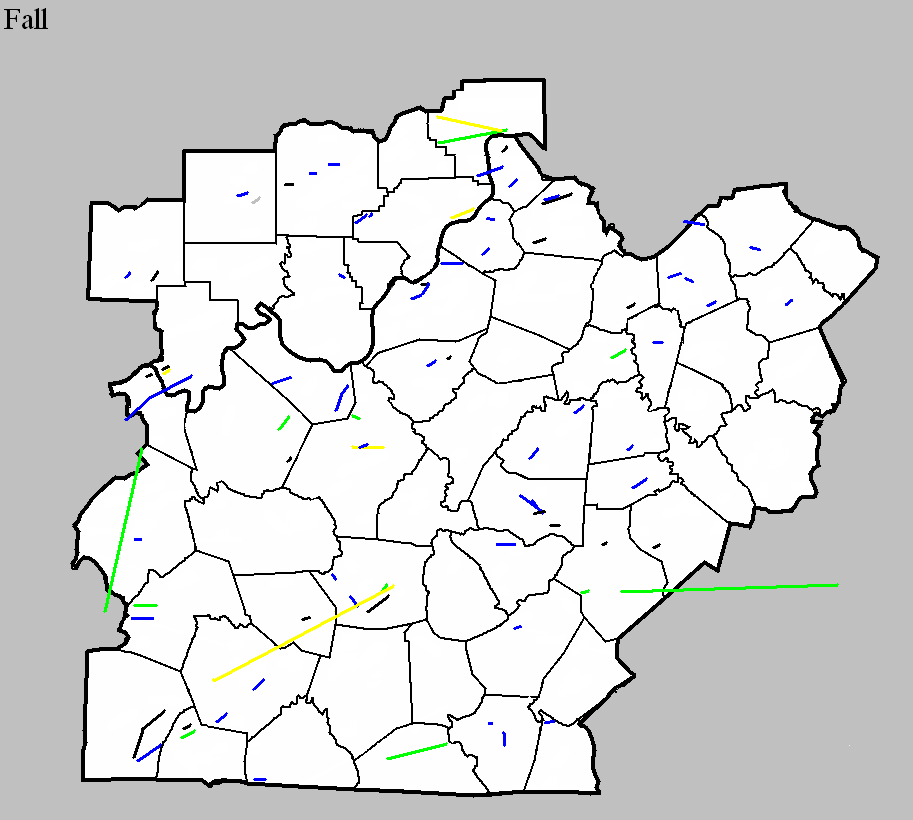
Narrative: A tornado, which possessed a "wrenching, spiral motion" according to witnesses and was described in the newspaper as "whirling and tossing about like a monster in pain" moved northeast through the southeast part of Louisville, damaging over a hundred buildings. A warehouse containing five hundred barrels of whiskey was destroyed. The tornado touched down near the intersection of Saint James Court and Magnolia Avenue, where it tore down several fences in Central Park. The first home damaged was on Fourth Street opposite the park. Eagle Park (primarily used for baseball) was damaged between Third and Fourth streets and Ormsby and Park avenues, and a home was damaged on Third Street opposite the park. Considerable damage was done in what was then known as Brownstown, and today is Old Louisville. Many roofs were removed there, and damage was reported at the corner of First and Ormsby. The tornado then intensified and produced some of its worst damage at Preston Street and Mechanic Street (Mechanic Street was today's Saint Catherine and Mary streets). Houses were unroofed at the intersection of Preston and Mechanic, a small brick slaughterhouse on Mechanic was demolished, and a two and a half story brick house on Mechanic was badly damaged. Continuing to the northeast, a home was damaged at the corner of Kentucky and Shelby streets and brick cottages on Kentucky near Shelby were wrecked. A roof was removed on Mary Street near Swan Street, and some light damage was done along Fischer Avenue, though those damages were probably from straight-line winds. The tornado advanced to the northeast. Significant damage occurred on Broadway near Cave Hill Cemetery. The twister then moved into the cemetery and inflicted terrible damage to trees and monuments. The arch over the northern gateway was blown over. The tornado lifted in the Irish Hill neighborhood. Click here for a detailed map of the approximate path of the center of the tornado.
October 29, 1883
Counties: Bourbon
F-scale: F1
Deaths: 2
Injuries: 1
Path width:
Path length: 6 miles
Time: 2:00am
Grazulis Narrative: Tornado moved from "Husto" to "Kinney Station". Two people were killed in one rural building. Most of the path was through dense forest.
NWS Notes: While Lexington newspapers listed the many farms that were struck by the tornado (or its attendant straight-line winds), no road names and few references to nearby towns were given. However, Grazulis's "Kinney Station" was likely Kenney Station, which today is Monterey, located 4 miles southwest of Paris. "Husto" was possibly Huston, named for a local landowner with that name, though it is unclear exactly where Huston was located, though it may have been where Paris sits today. Lexington newspapers stated that the "cyclone did great damage," including unroofing J. L. Taylor's clothing store across the street from the courthouse in Paris. Warehouses were unroofed along Stoner's Creek. G. W. Bedford's barn was blown down, and an old stone house on the Clay Farm was destroyed, killing two people inside the house (Maria Johnson and a young boy). The Morris Gass Farm also received damage. The cyclone moved from south to north "over the lower edge" of Paris. Several buildings were unroofed. The warehouse of Mr. Tarr was completely destroyed. "Several church spires were bent, while the dome on the courthouse rocked to and fro at an alarming rate. The track of the cyclone was very narrow." It appears that tornadoes may have also struck Franklin, Anderson, and Fayette Counties on this day.
October 16, 1925
Counties: Warren, Edmonson, Hart
F-scale: F3
Deaths: 1
Injuries: 44
Path width: 300 yards
Path length: 45 miles (probably a family of tornadoes)
Time: 4:00pm
Notes: A family of tornadoes and downbursts moved from six miles west of Bowling Green to beyond Munfordville. Homes were wrecked near Kuykendall's Store west of Bowling Green and in Davenport on Barren River Pike. Three houses and four barns were blown into the Barren River at Thomas Landing, injuring ten people. A car was blown off the road, over a fence, and into a field. The vehicle landed on its tires and the driver survived, despite the top half of the car getting sheared off. Additional damage occurred in the Richardsville area. In Edmonson County, barns and a hotel were torn apart near Mammoth Cave National Park, along with the home of a cave tour guide. In Hart County the tornado and its attendant straight-line winds mowed down a path five miles wide. Three people were injured as houses were unroofed and barns destroyed. Canmer and Woodsonville were the hardest struck districts. Seven barns were blown down near Munfordville.
October 31, 1934
Counties: Casey, Lincoln, Pulaski (and on into Rockcastle and Laurel)
F-scale: F2
Deaths: 6
Injuries: 32
Path width: 300 yards
Path length: 45 miles (probably a family of skipping tornadoes)
Time: 5:30pm
Narrative: A complex series of tornadoes and downbursts produced over $350,000 damage in a nine-county area of central Kentucky. The destruction of forty barns in Hart County and damage to 57 homes in Taylor County was likely from straight-line downburst winds. The likelihood of tornado involvement seemed to begin near Gilpin, continued east, passing south of Eubank, and ending in northern Laurel County. One person died in a home near Gilpin. A mother and four children died in one home on the Laurel County side of the Rockcastle River, fifteen miles northwest of London. Their home, which was destroyed, caught fire and only one child could be rescued. Most of the injuries were in the Gilpin-Mount Olive area.
November 5, 1948
Counties: Butler
F-scale: F2
Deaths: 0
Injuries: 0
Path width:
Path length: 3 miles
Time: 4:30am
Narrative: Moved east from near Rochester, unroofing a school and destroying a gym. Farm buildings were destroyed.
November 5, 1948
Counties: Hardin
F-scale: F3
Deaths: 1
Injuries: 2
Path width: 50 yards
Path length: 6 miles
Time: 5:45am
Notes: Wind damage occurred in a five mile wide swath from Howe Valley to three miles east of Elizabethtown. Within this area of high winds, an F3 tornado swept from about two miles northwest of Cecelia to three miles east of Elizabethtown. The worst of the tornado took place at its inception on Bethlehem Academy Road, where a barn was destroyed killing a woman inside. A nearby house was lifted bodily from its foundation, power lines were torn down, and a white leghorn rooster was stripped of its feathers. Trees were blown down in Saint John. Proceeding further to the east, power lines were downed on Old Cecilia Road and a barn was destroyed on Saint John Road three miles west of Elizabethtown. The tornado then weakened considerably, and the only significant damage done in Elizabethtown was power lines getting ripped down on North Dixie Highway. Leaving town, the tornado restrengthened and demolished a barn and a nearby house, and unroofed several homes three miles from Elizabethtown on US 62, where the twister grew to a quarter mile wide. However it dissipated soon thereafter. Straight-line winds tore down trees and power poles and damaged barns at Howe Valley, Franklin Cross Roads, Cecilia, Patterson, Tabb (four miles west of Elizabethtown on US 62), Glendale, Sonora, and on Springfield Road three miles east of Elizabethtown.
November 20, 1950
Counties: Scott, KY
F-scale: F1
Deaths: 0
Injuries: 0
Path width: 100 yards
Path length: 5 miles
Time: 4:00am
Notes: A strong thunderstorm passed through Georgetown in the pre-dawn hours. Wind damage was spread across about a six mile wide swath south through east of town, with a small tornado embedded within. The actual tornado probably touched down just west of Lexington Road about 3/4 of a mile northwest of the Fayette County line. It traveled to the northeast across Lemons Mill Road and then to the north-northeast along Crumbaugh Road, across Paris Pike, and up Old Oxford Road, dissipating before reaching Cynthiana Road. The first places hit were the Anderson Farm about three miles south of Georgetown, where a cabin lost its roof, the Showalters Farm just south of there, and Julia Marcum's place next door to the Showalters. Julia's barn's roof was blown into Georgetown Cemetery. Then the barn of T. P. Pickett was unroofed on Lemons Mill Road. On Lemons Mill Pike the John Drake Farm and the home of Dr. S. S. Amerson were hit. Turning more towards the north, the roof of a barn on Crumbaugh Road owned by C. A. Thornton was blown off. The Earl Watson farm was damaged as the tornado crossed Paris Pike. The worst damage of the event occurred just before the tornado dissipated, when it removed the roof and broke the windows of a home owned by Lewis Oliver on Old Oxford Road. The house was built in 1777 (this project wonders if it was the Charles Whitaker House). After then damaging the Hixson Farm, the twister dissipated. One resident on Oxford Pike said, "The noise of the twister was worse than the noise of a train passing near you." Trees were uprooted all along the tornado's path. Nearby straight-line wind damage in Georgetown was comparatively light. A barn was slightly damaged in the South Hudson neighborhood, a barn was damaged on Fountain Avenue, and the home of Sheriff Deputy Murphy on Clayton Avenue lost its two chimneys and suffered other roof damage as well.
Noted discrepancies: SPC and NCDC call this an F1, Grazulis calls it an F2. SPC gives a path length of 1/10 of a mile, NCDC provides no length, and Grazulis gives a length of 5 miles. SPC gives a width of 10 yards, NCDC provides no width, and Grazulis gives 100 yards. Grazulis' path length and width are probably more correct.
November 18, 1957
Counties: Boyle
F-scale: F1
Deaths: 0
Injuries: 0
Path width: 10 yards
Path length: 3 and a half miles
Time: 4:25pm to 4:30pm
Notes: Tornado touched down on the Charles Caldwell Farm 3.5 miles southwest of Danville on Lebanon Road. The tornado moved northeast into Danville, lifting shortly after causing damage at 435 Frye's Lane south of downtown. A dozen homes lost their roofs, and about a million dollars (1957) in damage was done. A tobacco warehouse was demolished on the southwest side of town. Along the tornado's path, plate-glass windows, signs, trees, and smaller buildings were smashed.
Noted discrepancies: NCDC and SPC storm databases place a tornado in Metcalfe County at this time, and nothing in Boyle County. Storm Data shows the tornado in Boyle County, and nothing in Metcalfe County. Further research suggests that the Boyle County tornado did indeed happen as described above. In Metcalfe County, damage reported at Center and Sulphur Well appears to be from straight-line winds. The Metcalfe County damage consisted of house and barn damage, but was spread across an area three miles wide. Lexington Weather Bureau meteorologist Dix Newtown felt it was straight-line wind damage at the time. Some witnesses thought there might have been a small tornado, but no credible eye-witness accounts of a visible funnel were received. On this date a large tornado outbreak struck from Kentucky south to the Gulf States, so it's certainly within the realm of possibility that a small tornado, perhaps embedded in straight-line winds, struck somewhere in Metcalfe County. However, going on the research done by this project up to this point, it has been determined that there was a small tornado in Boyle County, but no tornado in Metcalfe County. If you have information you'd like to share about either storm, please let us know.
October 10, 1959
Counties: Orange
F-scale:
Deaths:
Injuries:
Path width:
Path length:
Time: 11:15pm
Noted discrepancies: SPC gives a path length of 1/10 of a mile...NCDC gives nothing. SPC gives a path width of 10 yards, NCDC gives nothing. The lack of an F-scale is frustrating. Storm Data mentions that the tornado was small and the worst damage seems to have been the destruction of a barn. It also apparently hit a cemetery and "toppled 50 tombstones". It struck on IN 56 midway between Paoli and Millersburg. Would guess it was an F1, but more research is needed to get a better idea of this tornado's f-scale.
October 7, 1965
Counties: Jefferson IN
F-scale: F2
Deaths:
Injuries:
Path width:
Path length:
Time: 6:00pm
Noted discrepancies: SPC and NCDC list this as an F2...Grazulis does not list it.
Notes: Storm Data says this tornado touched down one mile west of Kent and moved east for two miles.
November 26, 1965
Counties: Metcalfe
F-scale: F2
Deaths: 1
Injuries: 1
Path width: 30 yards
Path length: 6 miles
Time: 11:00pm
Notes: Moved east from east of Hiseville to Savoyard and Sulphur Well. A trailer was demolished east of Savoyard, in which a woman named Glinda Jeffries was killed. Her body was carried about 100 yards. Her husband was injured. Their 2-year-old son remained unhurt.
Personal account from Brent Jeffries, cousin of Ronnie Jeffries, who was Glinda's husband: Tee Jeffries, Ronnie's father, went to the trailer to tell them that a bad storm was coming up and asked if they wanted to go to his house. Tee's house was right beside Ronnie's trailer. Ronnie said, "No we are just going to go to bed." So Tee started walking back to his house. Just as soon as Tee got on his car porch the tornado hit and sucked him up against the wall of his house. It threw Ronnie and Timmy, Ronnie's only son, into a mud puddle with just a few scratches. They found Glinda up in trees about 100 yards in front of her trailer. Tee climbed the tree and got her out. He said it felt like every bone in her body was broken but, she was still alive. They rushed her to T J Samson Community Hospital in Glasgow but, she died in Tee's arms about half a mile from the hospital. I was just 4 years old at the time but, I remember the wind blowing hard all that day. After the tornado hit my parents woke me up and we drove up there just about a mile away.
Noted discrepancies: SPC and NCDC give a path length of 5 miles, Grazulis and Storm Data give 6 miles (which appears more accurate). SPC gives a path width of 10 yards, NCDC 30 yards, Grazulis gives nothing. SPC/NCDC start this tornado at Savoyard in Metcalfe County...Grazulis and Storm Data start it "east of Hiseville" with Grazulis starting it in Barren County but Storm Data only mentioning Metcalfe County (Hiseville is three miles inside Barren County) on KY 314. In subsequent research, no evidence has been found of damage in Barren County, so will only include Metcalfe County at this time.
November 26, 1965
Counties: Anderson
F-scale: F2
Deaths: 0
Injuries: 8
Path width:
Path length: 3 miles
Time: 11:05pm
Grazulis narrative: Moved northeast from west of Lawrenceburg to the edge of town. A trailer was demolished, and the occupants were severely injured. A brick building was unroofed and had a wall blown down. Many buildings had roof or other damage.
Noted discrepancies: SPC, NCDC, and Storm Data give a path length of 3 miles, Grazulis gives 6 miles. SPC gives a path width of 10 yards, NCDC 30 yards, Storm Data 500 yards, Grazulis nothing. Grazulis times this tornado one hour later (12:05am November 27)...could be a time zone issue here (either with Grazulis or the NWS).
Notes: Storm Data says this tornado touched down initially west of Lawrenceburg and moved into the downtown section of that city. The storm then lifted but came back down at the eastern edge of town. According to news accounts, damage was heavy in Lawrenceburg, especially in a three-block wide swath through downtown. The Anderson County courthouse lost some of its roof.
October 24, 1967
Counties: Dubois
F-scale: F3
Deaths:
Injuries:
Path width:
Path length:
Time: 3:45pm
Noted discrepancies: SPC and NCDC list this as an F3, Grazulis does not list it. SPC gives a path length of 1/10 of a mile and a width of 10 yards...NCDC gives nothing for either.
Notes: Hard to believe and F3 tornado with a path length and width as small as what SPC gives. Also hard to believe the NWS would give it an F3 rating and Grazulis would only give it an F1 or less. Something odd here. The only damage described in Storm Data done directly by the tornado is the destruction of a concrete poultry house south of Dubois on IN 162 (which also sounds weird since IN 162 is not in close proximity to Dubois and is nowhere near the lat/lon given by SPC/NCDC). Additional research necessary!
September 3, 1970
Counties: Dubois
F-scale: F1
Deaths:
Injuries:
Path width:
Path length:
Time: 2:09pm
Noted discrepancies: None
September 3, 1970
Counties: Clark IN
F-scale: F1
Deaths:
Injuries:
Path width:
Path length:
Time: 3:30pm
Noted discrepancies: According to Storm Data this tornado touched down between Borden and Pekin just southwest of IN 60...would that be modern-day IN 160?
November 19, 1970
Counties: Ohio
F-scale: F2
Deaths: 0
Injuries: 18
Path width: 600 yards
Path length: 37 miles (skipping)
Time: 10:25pm
Notes: This tornado likely touched down in eastern Muhlenberg County and traveled roughly northward through western Ohio County, including the Echols, Rockport, and Hartford areas, and into far eastern Daviess County around Whitesburg. In the Rockport and Echols area the tornado was up to a quarter mile wide. It destroyed a dozen houses and half a dozen mobile homes, damaged 40 other houses and several barns to some degree, and injured eleven people. In Hartford two children were hospitalized when their trailer was overturned. The tornado did its worst in Whitesville in Daviess County, damaging much of the town.
Noted discrepancies: SPC lists Ohio and Daviess counties...NCDC lists only Ohio County...Grazulis lists Muhlenberg and Ohio counties. SPC/NCDC lat/lon list this tornado as touching down in Daviess County, and provide no liftoff lat/lon. Grazulis has the tornado starting in Muhlenberg County east of Greenville and he lifts it at Hartford in Ohio County (nowhere near the SPC/NCDC lat/lon). SPC and NCDC list no injuries, Grazulis and Storm Data list 18. SPC gives a path length of 1/10 of a mile (obviously wrong), NCDC gives nothing, and Grazulis gives 20 miles. SPC gives a path width of 10 yards, NCDC and Grazulis give nothing. Storm Data mentions tornado-like damage at Whitesville in Daviess County.
November 19, 1970
Counties: Perry IN
F-scale: F3
Deaths:
Injuries:
Path width:
Path length:
Time: 10:47pm
Noted discrepancies: SPC and NCDC rank this as an F3...Grazulis does not list it. The worst damage mentioned in Storm Data is the destruction of a barn and three farm buildings, along with scattered roof damage and a "wrecked" trailer.
Notes: According to Storm Data the tornado touched down on the southwest side of IN 66 at the west edge of Tell City. The storm crossed IN 66 into a cemetery and trailer court.
November 25, 1973
Counties: Trimble
F-scale: F1
Deaths:
Injuries:
Path width:
Path length:
Time: 4:00am
Noted discrepancies: SPC gives a path width of 10 yards, NCDC gives 30 yards.
September 26, 1976
Counties: Jefferson IN
F-scale: F3
Deaths: 1
Injuries: 1
Path width:
Path length:
Time: 4:55pm
Grazulis narrative: Moved east-southeast from west of Deputy to two miles northeast of Madison. Two houses, a trailer, and a barn were destroyed. One of the houses, a prefabricated home set on a concrete slab, "could not be found". Fortunately it was unoccupied. A man residing in the trailer was fatally injured, dying a week later from his injuries. A farm home was also destroyed.
Noted discrepancies: SPC and NCDC give a path length of 15 miles...Grazulis and Storm Data give 13 miles. Storm Data ends this tornado two miles northeast of Madison near IN 7. However IN 7 doesn't go northeast of Madison.
October 1, 1977
Counties: Harrison IN
F-scale: F1
Deaths: 1
Injuries: 1
Path width: 40 yards
Path length: 1/2 mile
Time: 7:00am
Grazulis narrative: Moved southeast, hitting a rural mobile home eight miles northeast of Corydon, blowing it apart, killing a man, and scattering debris for almost a mile. The side of a two-story home was torn off.
Noted discrepancies: SPC and NCDC list this as an F1, Grazulis says F2.
October 1, 1977
Counties: Marion
F-scale: F1
Deaths:
Injuries:
Path width:
Path length:
Time: 8:00am
Noted discrepancies: None
October 1, 1977
Counties: Fayette
F-scale: F1
Deaths:
Injuries:
Path width:
Path length:
Time: 8:00am
Noted discrepancies: SPC's beginning lat/lon is in Scott County KY. Cannot plot this tornado without further research.
October 1, 1977
Counties: Hardin
F-scale: F2
Deaths: 0
Injuries: 0
Path width: 30 yards
Path length: 2 miles
Time: 4:00pm
Grazulis narrative: A new brick home was destroyed and the neighboring home was unroofed in a brief touchdown in Radcliff.
Noted discrepancies: SPC and NCDC list this as an F2, Grazulis calls it an F3. SPC and NCDC time it at 4:00pm, Grazulis and Storm Data 6:00pm. SPC, Grazulis, and NCDC list the path width at 30 yards, Storm Data says 1 yard.
September 22, 1980
Counties: Oldham
F-scale: F1
Deaths:
Injuries:
Path width:
Path length:
Time: 3:05pm
Notes: Storm Data mentions Demplytown and Buckner.
September 14, 1984
Counties: Franklin
F-scale: F0
Deaths:
Injuries:
Path width:
Path length:
Time: 2:30pm
Noted discrepancies: None
September 18, 1992
Counties: Jefferson IN, Trimble
F-scale: F1
Deaths:
Injuries:
Path width:
Path length:
Time: 4:02pm
Noted discrepancies: This tornado appears to be in the SPC database twice. SPC's endpoint lat/lon is in Trimble County. SPC path length is only one mile, however. Trimble County is included at NCDC, with begin and end lat/lons identical to each other and to the end lat/lon given at NCDC for Jefferson County. Storm Data says this tornado touched down a half mile south of Paynesville, and does mention that the tornado continued into Trimble County to near Mount Pleasant. Will plot in both Jefferson and Trimble counties, as specified by given lat/lons.
September 18, 1992
Counties: Henry
F-scale: F1
Deaths:
Injuries:
Path width:
Path length:
Time: 4:25pm
Noted discrepancies: SPC gives a time of 4:25pm, NCDC gives 3:25pm.
November 22, 1992
Counties: Henry
F-scale: F0
Deaths:
Injuries:
Path width:
Path length:
Time: 3:20pm
Noted discrepancies: SPC gives a time of 3:20pm, NCDC 2:20pm, Storm Data 4:20pm.
Notes: Storm Data says this tornado struck the north edge of Smithfield.
November 22, 1992
Counties: Henry
F-scale: F0
Deaths:
Injuries:
Path width:
Path length:
Time: 3:40pm
Noted discrepancies: SPC gives a time of 3:40pm, NCDC says 2:40pm, Storm Data says 4:40pm.
Notes: Storm Data says this tornado touched down just north of Campbellsburg, then northeast of Tucker Station, then near Port Royal near the Carroll County line.
November 14, 1993
Counties: Mercer
F-scale: F1
Deaths:
Injuries:
Path width:
Path length:
Time: 8:31am
Notes: Storm Data says this tornado touched down three miles south of Harrodsburg.
November 7, 1996
Counties: Logan
F-scale: F0
Deaths: 0
Injuries: 0
Path width: 30 yards
Path length: 10 miles (skipping)
Time: 12:35pm
Notes: This small tornado did $500,000 damage to planes at Logan County Airport. Five planes were destroyed.
November 7, 1996
Counties: Simpson
F-scale: F0
Deaths:
Injuries:
Path width:
Path length:
Time: 12:55pm
Noted discrepancies: Storm Data puts this tornado near Stowers...but can't find a Stowers on any map.
November 7, 1996
Counties: Hart
F-scale: F0
Deaths:
Injuries: 5
Path width:
Path length:
Time: 1:45pm
Notes: Storm Data mentions damage at Horse Cave and Hardyville.
November 9, 2000
Counties: Hart
F-scale: F1
Deaths:
Injuries:
Path width:
Path length:
Time: 1:06pm
Notes: Storm Data takes this tornado from one mile southwest of Blowing Springs to one mile northwest of Blowing Springs.
November 9, 2000
Counties: Hart
F-scale: F1
Deaths:
Injuries:
Path width:
Path length:
Time: 1:15pm
Noted discrepancies: SPC lists a path width of 70 yards, NCDC 73 yards, Storm Data 75 yards. The lat/lon for this tornado shows it moving northwest, though no mention of that is made in the NCDC narrative. Storm Data moved this tornado from three miles northwest of Horse Cave to five miles northwest of Horse Cave.
November 9, 2000
Counties: Cumberland
F-scale: F1
Deaths:
Injuries:
Path width:
Path length:
Time: 1:40pm
Noted discrepancies: SPC lists a path width of 70 yards, NCDC 73 yards, Storm Data 75 yards.
Notes: Storm Data takes this tornado from one mile southwest of Burkesville to one mile northwest of Burkesville.
November 9, 2000
Counties: Marion
F-scale: F1
Deaths:
Injuries:
Path width:
Path length:
Time: 1:53pm
Notes: Storm Data places this tornado two miles southeast of Lebanon.
November 9, 2000
Counties: Washington, KY
F-scale: F1
Deaths:
Injuries:
Path width:
Path length:
Time: 1:55pm
Noted discrepancies: SPC lists a path width of 70 yards, NCDC 73 yards, Storm Data 75 yards.
Notes: Storm Data takes this tornado from half a mile south of Saint Catherine to one and a half miles northeast of Saint Catherine.
November 9, 2000
Counties: Washington KY
F-scale: F1
Deaths:
Injuries: 1
Path width:
Path length:
Time: 2:10pm
Noted discrepancies: SPC lists a path width of 70 yards, NCDC 73 yards, Storm Data 75 yards.
Notes: Storm Data takes this tornado from half a mile northeast of Sharpsville to two miles northeast of Sharpsville.
November 9, 2000
Counties: Woodford
F-scale: F1
Deaths:
Injuries:
Path width:
Path length:
Time: 2:34pm
Noted discrepancies: SPC lists a path width of 70 yards, NCDC 73 yards, Storm Data 75 yards.
Notes: Storm Data takes this tornado from one mile northwest of Versailles to one mile north of Versailles.
October 4, 2002
Counties: Jefferson KY
F-scale: F1
Deaths:
Injuries:
Path width: 50 yards
Path length:
Time: 5:47pm
Noted discrepancies: SPC lists a path width of 17 yards, NCDC and Storm Data say 50 yards.
Notes: Storm Data says this tornado touched down on the Ohio River 8.4 miles northeast of Louisville, moved through the Springhurst area of Louisville, struck the Indian Springs Country Club, and lifted 12.6 miles northeast of Louisville. Wonder if this formed in the remnants of Hurricane Lili?
November 10, 2002
Counties: Allen
F-scale: F1
Deaths:
Injuries:
Path width: 25 yards
Path length:
Time: 2:00am
Noted discrepancies: SPC lists a path width of 7 yards, NCDC 27 yards, Storm Data 25 yards.
Notes: Storm Data says this occurred near New Roe. Lat/lon given place it in Sumner County, Tennessee. Will plot it between New Roe and the Tennessee border.
November 10, 2002
Counties: Casey
F-scale: F0
Deaths:
Injuries:
Path width: 25 yards
Path length:
Time: 7:30pm
Noted discrepancies: SPC lists a path width of 7 yards, NCDC 27 yards, Storm Data 25 yards.
Notes: Storm Data says this struck Peyton Ridge.
November 10, 2002
Counties: Lincoln
F-scale: F0
Deaths:
Injuries:
Path width:
Path length:
Time: 7:45pm
Noted discrepancies: SPC lists a path width of 7 yards, NCDC 27 yards, Storm Data 25 yards.
Notes: Storm Data says this tornado struck Angel Ridge.
November 6, 2005
Counties: Hart
F-scale: F2
Deaths: 0
Injuries: 0
Path width: 200 yards
Path length: 1 mile
Time: 4:41am
Notes: This tornado struck downtown Munfordville. The tornado caused major damage to 44 homes and two businesses. Twenty-five homes were declared uninhabitable. Six businesses and 34 homes had minor damage. Munfordville Elementary School had part of its roof removed. About 50 vehicles in a car dealership lot were totaled.
November 15, 2005
Counties: Logan
F-scale: F1
Deaths: 0
Injuries: 0
Path width: 150 yards
Path length: 8 miles
Time: 5:36pm
Notes: This tornado touched down just north of Adairville. Many homes, trailers, outbuildings, and barns were damaged along the tornado's intermittent path. The tornado lifted near the Simpson County line near KY 100.
November 15, 2005
Counties: Simpson
F-scale: F2
Deaths: 0
Injuries: 0
Path width: 150 yards
Path length: 1 mile
Time: 5:52pm
Notes: This tornado touched down near Pilot Knob. It damaged trailers and downed many trees. Minimal F2.
November 15, 2005
Counties: Warren
F-scale: F1
Deaths: 0
Injuries: 0
Path width: 150 yards
Path length: 1 mile
Time: 6:07pm
Notes: This tornado touched down in the Woodburn area. It did F1 damage to at least three businesses, six homes, and numerous barns and outbuildings.
October 18, 2007
Counties: Jefferson, KY
EF-scale: EF0
Deaths: 0
Injuries: 0
Path width: 75 yards
Path length: Less than 440 yards
Time: 7:10pm EDT to 7:11pm EDT
Notes: Touched down at the Kroger's store at 2200 Brownsboro Road. Windows were blown out, a cart corral was blown into a vehicle, and a power pole was blown down.
October 18, 2007
Counties: Hancock, Perry
EF-scale: EF1
Deaths: 0
Injuries: 0
Path width: 220 yards
Path length: 14 miles (skipping)
Time: 6:18pm CDT to 6:45pm CDT
Notes: This tornado touched down along the Daviess County line near Gatewood and did primarily tree and power line damage as it headed northeast. The tornado lifted slightly and passed over Hawesville as a funnel cloud (though 75 mph winds still did damage in town). The tornado came back to earth just on the other side of Cannelton and proceeded northeast into the Hoosier National Forest, damaging the Girl Scout Camp on Cann Heights Road and lifting at Plock Knob.
October 18, 2007
Counties: Clark, IN
EF-scale: EF3
Deaths: 0
Injuries: 0
Path width: 440 yards
Path length: 5 miles (skipping)
Time: 10:03pm EDT to 10:09pm EDT
Notes: Began on Bull Creek Road west of Vesta where it scoured the ground. Moving northeast, it devastated a home near Hibernia when the two-story house was blown completely off of its basement foundation and destroyed. Two large barns, a silo, and a stable were also destroyed on the same property. The tornado lifted just shy of the Ohio River near the end of Fulton Road.
October 18, 2007
Counties: Breckinridge
EF-scale: EF2
Deaths: 0
Injuries: 0
Path width: 300 yards
Path length: 3 miles
Time: 9:26pm CDT to 9:33pm CDT
Notes: Touchdown was a mile east-northeast of Stinnettsville. The tornado moved northeast and produced major damage in Rosetta where it destroyed the Fountain of Faith Church. A 4500 pound tractor was moved seven feet and a 16-foot trailer was wrapped around a tree. The tornado lifted near the intersection of KY 333 and M. H. Dowell Road.
October 18, 2007
Counties: Dubois
EF-scale: EF0
Deaths: 0
Injuries: 0
Path width: 125 yards
Path length: 2 miles
Time: 9:27pm EDT to 9:30pm EDT
Notes: The door of a house was blown out about four miles northeast of Ferdinand, near the start of the tornado path. A barn was damaged about a half mile
south of Kyana, near the end of the damage path. Over 100 large oak trees were snapped off or uprooted in the Ferdinand Forest.
October 18, 2007
Counties: Meade
EF-scale: EF1
Deaths: 0
Injuries: 0
Path width: 300 yards
Path length: 2.5 miles
Time: 10:50pm EDT to 10:55pm EDT
Notes: This tornado began one mile northeast of Flaherty, damaged buildings at the intersection of US 60 and KY 1882, and lifted in western Fort Knox near Camp Carlson.
October 18, 2007
Counties: Bullitt
EF-scale: EF1
Deaths: 0
Injuries: 0
Path width: 200 yards
Path length: 2.5 miles (skipping)
Time: 11:20pm EDT to 11:26pm EDT
Notes: Damage was done to homes in the south end of Brooks along Meadowbrook Drive, Clearbrook Drive, Hillbrook Drive, Bells Mill Road, and Hill Creek Road.
October 19, 2007
Counties: Marion
EF-scale: EF0
Deaths: 0
Injuries: 0
Path width: 50 yards
Path length: 0.5 mile
Time: 1:36am EDT to 1:38am EDT
Notes: Touched down just northwest of Bradfordsville and moved east across the north side of town. A mobile home was rolled over and trees and power lines were blown down.
September 20, 2009
County: Clark IN
EF-scale: EF1
Deaths: 0
Injuries: 0
Path width: 35 yards
Path length: 0.75 mile
Time: 5:58pm - 5:59pm EDT
Notes: The tornado uprooted and snapped several large trees and destroyed a small shed on Daisy Hill Road north of Borden. One snapped tree came down onto the roof of a home and did considerable damage.
October 9, 2009
County: Breckinridge
EF-scale: EF0
Deaths: 0
Injuries: 0
Path width: 100 yards
Path length: 0.5 mile
Time: 2:20am - 2:21am CDT
Notes: Several mobile homes were damaged and trees were snapped on Lyons-Daughtery Road. Two barns were destroyed.
October 9, 2009
County: Monroe
EF-scale: EF2
Deaths: 0
Injuries: 0
Path width: 880 yards
Path length: 15.6 miles
Time: 1:20pm - 1:36pm CDT
Notes: This tornado touched down near Flippin and inflicted EF-1 damage on trees between Flippin and Mud Lick. After Mud Lick the tornado strengthened and damaged homes, barns, and trees on its way to Rockbridge.
October 9, 2009
County: Casey
EF-scale: EF2
Deaths: 0
Injuries: 0
Path width: 95 yards
Path length: 1.5 miles
Time: 2:36pm - 2:38pm EDT
Notes: Several structures were badly damaged as the tornado moved along KY 70 from Elm Drive to KY 206.
October 26, 2010
County: Trimble
F-scale: EF0
Deaths: 0
Injuries: 0
Path width: 20 yards
Path length: 1.2 miles
Time: 11:35am to 11:37 am EDT
Notes: This small tornado struck just southwest of Milton. The twister damaged the roofs of several outbuildings when it touched down. It struck a home on Liberty Road where it ripped the front porch off the home and flipped the detached metal garage. Neighboring homes on either side were undamaged.
October 26, 2010
Counties: Bullitt
F-scale: EF0
Deaths: 0
Injuries: 0
Path width: 75 yards
Path length: 0.1 mile
Time: 11:51am EDT
Notes: An EF-0 tornado struck Bogard Lane about four miles southwest of Mount Washington at 11:51am. The path was 150 yards long and 75 yards wide. A well-constructed concrete workshop was heavily damaged with a 3500 pound roof blown 45 yards away. A 125 pound chimney was blown 60 yards away. Insulation was found in nearby trees.
October 26, 2010
Counties: Warren
F-scale: EF1
Deaths: 0
Injuries: 0
Path width: 60 yards
Path length: 2.2 miles
Time: 11:08am CDT
Notes: A tree was uprooted at the beginning of the track. As the tornado crossed Cemetery Road it damaged a home. A barn was unroofed near the end of the track. Damage was intermittent along the 2.2 mile long, 60 yard wide path.
November 14, 2011
County: Orange
EF-Scale: EF1
Deaths: 0
Injuries: 0
Path width: 50 yards
Path length: 2 miles
Time: 7:32pm EST
Notes: The tornado spun up west of Star Field on the north side of the Paoli School Complex, destroying a 100 year old barn and heavily damaging the roofs of two other outbuildings. It then took a large section of roofing off the Paoli Police Department building on West Main Street before snapping several trees along Lick Creek as it moved east-northeast toward the city square. On the square, the tornado ripped the metal roofs off of Reflections Flower Shop and Liberty Furniture. Three chimneys of the Orange County Courthouse collapsed, most likely when hit by roof debris. After crossing the square, the tornado continued moving east-northeast for another one and a quarter miles, snapping and uprooting trees and causing minor roof damage to several homes. Near the end of its path, the tornado spread debris from a metal outbuilding one tenth of a mile onto North Marshall Road.
November 17, 2013
County: Butler
EF-Scale: EF1
Deaths: 0
Injury: 1
Path width: 200 yards
Path length: 5.3 miles
Time: 4:10-4:16pm CST
Notes: The tornado, with 105 mph winds, touched down approximately one mile west of Huntsville on Blaine Road where some trees were uprooted. The tornado then moved eastward into Huntsville where a few homes were damaged and trees were snapped along Huntsville-Quality Road. The tornado then continued east damaging trees, homes and small outbuildings just north of Silver City-Huntsville Road. One minor injury occurred in a double-wide that lost all of its roof and a couple of walls just west of the intersection of Silver City-Huntsville Road and Panther Creek Road. Intermittent minor damage then occurred east of this intersection. Finally, the tornado did a more concentrated area of damage along Muddy Creek Road where a few more homes and trees were damaged. The tornado quickly lifted 4 miles east of Huntsville.
October 6, 2014
County: Cumberland
EF-Scale: EF1
Deaths: 0
Injuries: 0
Path width: 100 yards
Path length: 0.2 mile
Time: 6:02pm CDT
Notes: Two hundred trees were uprooted on a ridge top near the end of Dug Road north of Burkesville.
October 6, 2014
County: Clinton
EF-Scale: EF1
Deaths: 0
Injuries: 0
Path width: 150 yards
Path length: 2.3 miles
Time: 6:13pm - 6:17pm CDT
Notes: This tornado struck about 11 miles NNW of Albany in the northwest tip of Clinton County. Numerous trees were snapped or uprooted. The only non-tree damage was to power poles along US 127. A couple in a vehicle on US 127 was trapped when trees fell across the highway both north and south of them.
October 7, 2014
County: Oldham
EF-Scale: EF1
Deaths: 0
Injuries: 0
Path width: 50 yards
Path length: 0.1 mile
Time: 2:50pm - 2:51pm EDT
Notes: A barn, several outbuildings, and two trees were damaged.
October 7, 2014
County: Scott, KY (from Owen)
EF-Scale: EF1
Deaths: 0
Injuries: 0
Path width: 150 yards
Path length: 4.1 miles
Time: 3:45pm - 3:50pm EDT
Notes: Most of the damage was to trees. The only structural damage was to a small home on the top of a hill near South Rays Fork Road. The porch roof was ripped from the home and thrown over the building, there was significant roof damage, and an above-ground pool was destroyed.
October 7, 2014
County: Scott, KY
EF-Scale: EF1
Deaths: 0
Injuries: 0
Path width: 150 yards
Path length: 2 miles
Time: 3:48pm - 3:49pm EDT
Notes: This tornado caused minor damage to the roofs of two houses and significant damage to the roof of another house. A small outbuilding was also destroyed.
October 7, 2014
County: Scott, KY
EF-Scale: EF1
Deaths: 0
Injuries: 0
Path width: 150 yards
Path length: 3.6 miles
Time: 3:50pm - 3:52pm EDT
Notes: Mostly tree damage occurred with this tornado. Near the end of its path two small barns were destroyed and two homes sustained roof damage.
October 7, 2014
County: Harrison, KY
EF-Scale: EF1
Deaths: 0
Injuries: 0
Path width: 275 yards
Path length: 3.9 miles
Time: 4:05pm - 4:10pm EDT
Notes: This tornado exhibited multiple vortices as it damaged or destroyed several outbuildings and barns. Significant numbers of large trees were snapped and/or uprooted as the tornado crossed US 27.
October 7, 2014
County: Bourbon
EF-Scale: EF1
Deaths: 0
Injuries: 1
Path width: 60 yards
Path length: 1.7 miles
Time: 4:12pm - 4:13pm EDT
Notes: Touchdown occurred near the Vine Street loop where damage was done to homes' roofs and siding. One woman was pulled out of her house and landed on her porch. Power lines and many trees were downed, some of which fell on homes. Tree and house damage also occurred at the end of Windamere Lane, and warehouses were damaged just before the tornado lifted at US 460.
November 5, 2017
County: Washington, IN
EF-Scale: EF0
Deaths: 0
Injuries: 0
Path width: 350 yards
Path length: 0.6 miles
Time: 11:04pm EST
Notes: This touchdown occurred approximately 5 miles west of Salem on SW Washington School Rd. The touchdown occurred along a forested area which threw branches and large portions of maple and cedar trees over the road approximately 300 yards. The most concentrated damage was at 1630 SW Washington School Rd. There was an uprooted tree, along with shingle, gutter, roof, and barn damage. Several toys and pumpkins were turned and thrown cyclonically towards the west. A trampoline was thrown approximately a mile from the house along with lots of playground toys being thrown several hundred yards. There were some trees down further along the farmer`s field, but the tornado lifted after traveling approximately 0.6 miles where a few trees were topped where it lifted. The peak wind speed was 80 mph and most of the damage was at the tree top level.
November 5, 2017
County: Washington, IN
EF-Scale: EF1
Deaths: 0
Injuries: 0
Path width: 40 yards
Path length: 0.3 miles
Time: 11:16pm EST
Notes: The tornado touched down in downtown Salem at the Salem Feed Mill on South Water Street. There was significant damage on the upper portion of the feed mill approximately 70 feet off the ground along with some power poles being severely bent. A multi-business building was hit by the tornado with a large portion of its roof lifted and dropped on the Dinner Bell restaurant. There was extensive damage from falling brick. The tornado then hit a house on the corner of Cherry and South High Street resulting in roof and siding damage along with several sections of Cleveland Pear trees snapped. The tornado lifted quickly at the intersection.
November 5, 2017
County: Washington, IN
EF-Scale: EF1
Deaths: 0
Injuries: 0
Path width: 70 yards
Path length: 0.5 miles
Time: 11:20pm EST
Notes: The tornado touched down near the intersection of Canton Road and Howell Road. Severe damage was sustained to several barns, street signs, bird houses, and metal poles that were bent or snapped. A 500 gallon propane tank moved to the south 3 feet and became lodged against a grain storage building. There was an excellent signature of mud and dirt spattering cyclonically on a grain silo. The tornado was extremely narrow and mostly at tree top level with several power poles snapped near the top.
November 18, 2017
County: Ohio
EF-Scale: EF1
Deaths: 0
Injuries: 1
Path width: 60 yards
Path length: 2 miles
Time: 3:20pm CST
Notes: This small tornado was embedded in a fast moving squall line that raced east at 55 mph. The twister first touched down at a home on U.S. Highway 62 just west of Goshen Church Road, tearing off shingles and uprooting a tree. It moved east-southeast, uprooting and snapping trees near the intersection of Hwy 62 and Goshen Church Rd, along with damaging some small outbuildings. It next downed a tree on Mine Fork Road that fell between a home and outbuilding, damaging both structures and causing a minor head injury to the occupant of the shed. Continuing over open fields, it next hit several residences along Hill, Mulberry, and South Mulberry streets before crossing U.S. Highway 231 and causing minor roof damage to the Post Office. The greatest damage occurred in this two block area, where up to a dozen outbuildings were destroyed or heavily damaged, and sections of roofing were lifted off homes and garages. Fences in the neighborhood were blown in a cyclonic pattern, providing evidence of the tight rotation pattern of the storm. After crossing Hwy 231, the tornado damaged several large warehouses, scattering wood and sheet metal debris. Along Bruce School Road, a chain link fence was flattened, and insulation was sucked out of the damaged roof of a two story home, then spattered along the east side of the home and adjacent vehicles. Another large tree was uprooted in this yard before the tornado lifted. Sheet metal and shingles were lifted into trees along the route of the storm.
November 18, 2017
County: Meade
EF-Scale: EF1
Deaths: 0
Injuries: 1
Path width: 50 yards
Path length: 1.8 miles
Time: 4:32pm EST
Notes: The tornado touched down just inside the Breckinridge-Meade County line north of Irvington. It pushed a large tobacco barn 15 feet eastward, tore off its roof, and collapsed several walls. Debris from the barn was scattered over a half mile downwind. The tornado moved east-northeast, skipping along a wooded area where several trees were snapped or uprooted, then hit a mobile home on Fackler Road, rolling the anchored unit several times, destroying the home. The owner sustained only minor injuries as he rolled over with his house, crawling out of a hole after it settled. A garage on the property was also destroyed. The tornado continued skipping along the northwest side of Sandy Hill Rd, damaging outbuildings on another farm, before crossing KY highway 261 at Guston Rd. A split level home on Guston Rd had part of its roof removed, with insulation spattered on the lee side of the home. An occupant of the home reported he was descending the
stairs as the roof was torn off, and was briefly drawn up the stairs as it occurred. Debris from the split level home was dropped across the road, where a few more trees were snapped and uprooted. The tornado then flattened a fence and peeled a section of sheet metal on an outbuilding before lifting.
November 18, 2017
County: Taylor
EF-Scale: EF1
Deaths: 0
Injuries: 0
Path width: 50 yards
Path length: 1.4 miles
Time: 6:00pm EST
Notes: This small, narrow squall-line spin-up tornado moved over rural countryside, damaging or destroying a half dozen outbuildings and doing minor tree damage as it traveled east-southeast over three farmsteads. Only minor roof damage occurred to one home in its path.
September 8, 2018
County: Perry
EF-Scale: EF0
Deaths: 0
Injuries: 0
Path width: 80 yards
Path length: 1.8 miles
Time: 2:38pm - 2:44pm EDT
Notes: The tornado touched down on Main Street in Tell City, midway between Steuben and Winkelreid Streets, doing minor damage to one roof and bending an amateur radio antenna tower. Moving east-northeast, the tornado damaged roofs and snapped several large tree limbs, as well as toppling a large but rotting tree that crushed the roof of a garage. A small shed was lofted out of its yard and became entangled in utility lines 30 yards to the northeast. As it crossed Winkelreid Street between 10th and 11th Streets, it buckled in a large overhead door and caused minor damage to the roof of the Indiana Southern Power building. Continuing to the northeast, a large metal carport was lifted and blown 50 feet north into neighboring trees, and more tree limbs were snapped, while a vinyl fence was blown northwest, as was a large trampoline and a patio umbrella, which was entangled in utility lines northwest of its origin. The tornado continued to cause tree damage as it moved east of 14th Street into a more rural area. On Brushy Fork Rd, the tornado snapped the trunks of three large trees, then continued northeast into a wooded area. The last evidence of the tornado was at the north end of Quaker Rd, where small branches were broken.
September 8, 2018
County: Hancock
EF-Scale: EF0
Deaths: 0
Injuries: 0
Path width: 50 yards
Path length: 5 miles
Time: 4:42pm - 4:54pm CDT
Notes: This tree-top level tornado did all of its damage 20 to 30 feet above ground. Never more than 50 yards wide, the first evidence of the tornado touching down was one mile south of the water tower on Thomas Lane, where it downed several large branches that blocked the road. Moving northeast over forested land, the next evidence was more tree trunks and branches snapped on Poplar Grove Rd just north of the intersection with Hilldale Rd. The tornado then continued to skip northeast, snapping branches and trunks to the west of Frank Luttrell Rd, before crossing the road and causing minor roof damage to the metal roof of a barn and snapping more tree limbs a third of a mile southeast of North Hancock Elementary School. The tornado dropped small branches and leaves along its path as it continued northeast. The last major tree damage was observed around a home on Adair Rd, where trees were uprooted and trunks snapped in a cyclonic pattern around the home. The only damage to the home, however, was minor roof damage from a branch falling on it. The storm then crossed Adair Rd, lifting somewhere in a wooded area west of a large pond near Beauchamp Lane, where residents witnessed its dissipation.
October 31, 2018
County: Hardin
EF-Scale: EF1
Deaths: 0
Injuries: 0
Path width: 80 yards
Path length: 2.5 miles
Time: 5:39pm - 5:43pm EDT
Notes: This brief, skipping tornado touched down initially as an EF0 near the east end of Labrador Way in a subdivision 1.5 miles south of Rineyville Elementary School. It did minor roof damage to two homes, tossed a trampoline into a neighboring home, causing siding damage, and pushed a large travel trailer onto a minivan, heavily damaging both. Mud was spattered onto the north-facing front of the home, where a porch column support was also moved slightly. From here it travelled east-northeast, snapping tree limbs as it skipped over mainly open pastureland until it reached Thomas Road. On the west side of Thomas Road, the tornado reached its greatest intensity and size, with winds of 100 mph. Here it damaged four outbuildings, completely destroying two - the largest being a 30 x 50 structure. The debris pattern from the four outbuildings and nearby trees with snapped trunks and limbs showed clear cyclonic rotation. Metal roofing and siding material were scattered nearly a quarter of a mile to the east-northeast, with some of it lofted into the trees of a heavily wooded area. Other building debris from the largest structure was blown to the northwest, and the south and east-facing walls of a number of structures were spattered with leaves and other ground-based vegetation. Three east-facing garage doors of one of the outbuildings were blown in, and damage was sustained to the vehicles in the driveway from downed tree limbs. Three homes in the area sustained roof and siding damage, including a 2x4 from one of the outbuildings blown through an exterior wall. The tornado became elevated as it continued east-northeast from Thomas Road, snapping a few tree limbs in a wooded area before briefly touching down one last time on Rineyville Road, where it littered the highway with tree limbs and tore the front porch off a home, vaulting the roof over the house into the back yard. Security cameras from a business next door captured the damage occurring as a wall of wind and water that occurred in less than half a minute. No further damage occurred to the east of this location as the tornado dissipated.
November 5, 2018
County: Edmonson
EF-Scale: EF0
Deaths: 0
Injuries: 0
Path width: 65 yards
Path length: 0.3 mile
Time: 9:53pm CST
Notes: A brief tornado touchdown was embedded at the end of a longer axis of straight line winds about 6.2 miles SE of Brownsville. Evidence of cyclonic rotation was noted in this concentrated area of damage where several 1 to 2 foot diameter trees were either uprooted or snapped. On the south side of the path, trees were laying in an ENE direction, with the trees on the left/north side of the path laying NNW. The tornado touchdown was very brief and lifted at the intersection of Cedar Sink Road and Brownsville Road just inside the southwestern border of Mammoth Cave National Park. Peak winds were estimated at 80 mph with a maximum path width of 65 yards. The path length was about a third of a mile and the tornado was on the ground for less than 1 minute.
November 5, 2018
County: Marion
EF-Scale: EF0
Deaths: 0
Injuries: 0
Path width: 60 yards
Path length: 2 miles
Time: 11:40pm - 11:42pm EST
Notes: This very small tornado touched down on top of an older wooden barn on KY 289 just south of the intersection with US 68. It flattened the structure, collapsing it to the southeast, while the metal roofing was distributed in a circulating pattern around it - from southeast to northeast to northwest, with the bulk being to the
northeast. A 3-legged TV tower next to the adjacent home was crumpled to the north-northeast. Other than mud spattering from the south-southwest on the back corner of the brick one-story home, no other evidence of wind was observed, as no shingles were damaged. The tornado immediately lifted over the home and nearby trees, then set back down in a subdivision on the west side of New Calvary Road, about a mile east where several small tree trunks were snapped, but no apparent structural damage occurred. The tiny twister then continued to the northeast, causing other minor tree damage to the south of Probus Lane.
November 5, 2018
County: Adair
EF-Scale: EF1
Deaths: 0
Injuries: 0
Path width: 150 yards
Path length: 3.8 miles
Time: 10:52pm - 10:56pm CST
Notes: This skipping tornado first touched down along Campbellsville Rd near the community of Cane Valley where it downed power lines as it snapped tree limbs and uprooted several large trees. Moving eastward over open fields, it tore most of the roof off a barn at the end of Doug White Road, plastering insulation from the barn onto the northeast side of the adjacent home. To the north of the barn and home, it tossed a 1500 lb. hay roll southeast over a fence. From here, the tornado raced east-northeast over more fields, where it snapped the tops off a few trees before it hit the next farm, at Milky Way Lane on Mt. Carmel Road. Here it destroyed one large outbuilding and tore much of the roof off another in addition to destroying two small grain hoppers. Flying debris damaged at least two other buildings and vehicles, with roofing debris scattered a quarter of a mile to the northeast. Across the road from these buildings, the tornado tore the roof off and partially collapsed the wall of another large outbuilding. Flying debris from this building damaged another outbuilding, while columns on the southwest-facing front porch of the farm home were blown out as the porch roof was briefly elevated. The tornado continued eastward, snapping the trunks of several large trees along Butler Creek and damaging carports and a metal outbuilding along Holmes Bend Rd and Turkey Trace. Again moving over open land, the final two buildings damaged were metal outbuildings on Willis Rd and near the intersection of West Egypt Rd and Knifley Rd. It also toppled the sign of the Green River Bait and Grocery before lifting as it crossed Knifley Rd.


 Weather Story
 Weather Map
 Local Radar
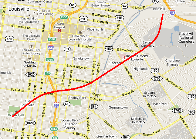