
Scattered severe thunderstorms capable of large to very large hail, damaging winds with potentially significant gusts, and perhaps a couple of tornadoes are expected Friday afternoon into night across portions of the central Plains into upper Great Lakes. Thunderstorms with heavy to excessive rainfall may produce flooding over a part of the Midwest Friday. Read More >
Louisville, KY
Weather Forecast Office
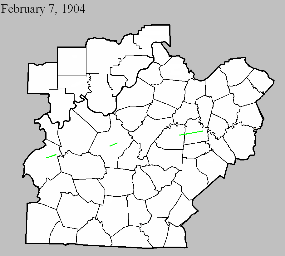
February 7, 1904
Counties: Washington, Mercer
F-scale: F2
Deaths: 0
Injuries: 11
Path width:
Path length: 15 miles
Time: 3:00am
Narrative: Moved east from ten miles west of Harrodsburg. The worst damage was at Cornishville, where seven homes, a church, and a bridge were destroyed. Other barns and homes were unroofed.
February 7, 1904
Counties: Ohio
F-scale: F2
Deaths:
Injuries:
Path width:
Path length: 5 miles
Time: 3:45am
Narrative: Moved east-northeast from Dundee to Narrows. Thirty homes and six businesses were destroyed at Narrows (virtually the entire village). Twelve more homes were destroyed at Dundee.
February 7, 1904
Counties: Hardin
F-scale: F2
Deaths: 0
Injuries:
Path width: 250 yards
Path length: 3 miles
Time: 4:25am
Narrative: Moved northeast along the southeast edge of Cecilia. A "substantial" brick church was leveled, as were many barns. Homes were unroofed. Trees pointed in towards the center on both sides of the track.
Current Hazards
Hazardous Weather Outlook
Storm Prediction Center
Submit a Storm Report
Advisory/Warning Criteria
Radar
Fort Knox
Evansville
Fort Campbell
Nashville
Jackson
Wilmington
Latest Forecasts
El Nino and La Nina
Climate Prediction
Central U.S. Weather Stories
1-Stop Winter Forecast
Aviation
IDSS Forecast Points
Air Quality
Fire Weather
Recreation Forecasts
1-Stop Drought
Event Ready
1-Stop Severe Forecast
Past Weather
Climate Graphs
1-Stop Climate
CoCoRaHS
Local Climate Pages
Tornado History
Past Derby/Oaks/Thunder Weather
Football Weather
Local Information
About the NWS
Forecast Discussion
Items of Interest
Spotter Training
Regional Weather Map
Decision Support Page
Text Products
Science and Technology
Outreach
LMK Warning Area
About Our Office
Station History
Hazardous Weather Outlook
Local Climate Page
Tornado Machine Plans
Weather Enterprise Resources
US Dept of Commerce
National Oceanic and Atmospheric Administration
National Weather Service
Louisville, KY
6201 Theiler Lane
Louisville, KY 40229-1476
502-969-8842
Comments? Questions? Please Contact Us.


 Weather Story
 Weather Map
 Local Radar