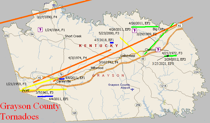
March 27, 1890
Counties: Ohio, Grayson, Breckinridge, Hardin
F-scale: F4
Deaths: 7
Injuries: 40
Path width: 1200 yards
Path length: 60 miles (probably a family of tornadoes)
Time: 8:00pm
Narrative: Moved east-northeast from seven miles northwest of Hartford. Many miles of forest were leveled, and small farm communities were wiped out. Homes were said to have "vanished" near Sulphur Springs (where two people were killed) and near Falls of Rough (where three people were killed). The last damage was near Rineyville, where two people were killed in one home.
March 16, 1942
Counties: Grayson, Hardin
F-scale: F4
Deaths: 9
Injuries: 40
Path width: 200 yards
Path length: 30 miles
Time: 6:15pm
Narrative: Moved east-northeast from north of Caneyville to near Summit. People died in seven different homes north of Caneyville, Millwood, Leitchfield, Clarkson, and Summit. About twenty homes were destroyed, and some were swept completely away. Two of the deaths were in Hardin County.
January 21, 1959
Counties: Grayson
F-scale: F3
Deaths: 3
Injuries: 5
Path width: 100 yards
Path length: 7 miles
Time: 12:30pm
Grazulis Narrative: Moved northeast in and near Neafus, Steff, Spring Lick, Goffs, Short Creek, Staff, and Caneyville. Four homes were destroyed in Neafus, and two each in Steff and Spring Lick. Ten buildings were destroyed on a farm.
Noted discrepancies: SPC, Storm Data, and NCDC list no injuries, but Grazulis lists 5. SPC gives a path width of 10 yards, NCDC 30 yards, Grazulis 100 yards.
May 7, 1961
Counties: Ohio, Grayson (from Hopkins and Muhlenberg)
F-scale: F3
Deaths:
Injuries:
Path width:
Path length:
Time: 9:25am
Grazulis narrative: Skipped east-northeast from Madisonville to Bremen, Moorman, and on to Beaver Dam. The Moorman High School gym was unroofed and a small home fell over.
Noted discrepancies: SPC and NCDC rank this as an F3, Grazulis gives it an F2. Grazulis does not include Grayson County. SPC, Storm Data, and NCDC give a time of 9:25am, Grazulis give 8:15am. SPC and NCDC give a path length of 58 miles, Grazulis give 35 miles (skipping), Storm Data gives 60 miles. SPC and NCDC give a path width of 880 yards, Storm Data says 1320 yards, Grazulis says 200 yards. This tornado is very oddly listed at the NCDC website. NCDC lists Hopkins County at 9:25am, then two entries for Muhlenberg County (one at 9:36am and the other at 9:41am), then two entries for Ohio County (one at 9:48am and the other at 9:56am), then one entry for Grayson County (at 10:17am). All entries have identical f-scale and path widths values. Storm Data begins the tornado in McLean County, and thereafter agrees with SPC. The NCDC end lat/lon of the first Muhlenberg tornado is the same as the NCDC begin lat/lon of the second. Similarly, the NCDC end lat/lon of the first Ohio tornado is the same as the NCDC begin lat/lon of the second. All lat/lons are roughly in alignment with each other and with the Grayson County lat/lons. Will plot a single tornado as close to the given lat/lons as possible. In the LMK CWFA, only Centertown and Beaver Dam (both Ohio County) are mentioned in the Storm Data narrative. More research would be nice, especially to determine if this tornado did continue into Grayson County or not.
January 24, 1964
Counties: Grayson
F-scale: F1
Deaths:
Injuries:
Path width:
Path length:
Time: 8:16pmNotes: Narrow swath through thick timber, evidence of rotary motion.
Noted discrepancies: SPC gives a path width of 10 yards and a path length of 1/10 of a mile...NCDC gives nothing for either. The only Kentucky event on this day in Storm Data is in Fulton County because the report for this tornado came in too late for inclusion in the publication.
April 21, 1972
Counties: Grayson
F-scale: F3
Deaths: 0
Injuries: 4
Path width:
Path length: 1 mile
Time: 9:00pm
Grazulis narrative: Hit two miles east of Clarkson. Two trailers were destroyed, and pieces were carried for a mile. Six frame homes were damaged.
Noted discrepancies: SPC and NCDC rank this as an F3, Grazulis gives it an F2. SPC gives a path width of 10 yards, NCDC 30 yards, Grazulis nothing.
Notes: According to Storm Data, the tornado touched down 2 miles east of Clarkson, and moved northeast for about a mile.
April 3, 1974
Counties: Grayson
F-scale: F4
Deaths: 0
Injuries: 2
Path width: 150 yards
Path length:
Time: 3:00pm
Grazulis narrative: Moved east-northeast from Tanyard to south of Caneyville, passing north of Leitchfield and ending near Big Clifty. The F4 rating is based on a single leveled home south of Caneyville
Noted discrepancies: Grazulis takes this tornado into Hardin County, though he says the damage ended at Big Clifty, which is in Grayson County about two miles from the Hardin County line. SPC/NCDC end it on the northwest side of Leitchfield. SPC and NCDC give a time of 3:00pm, Grazulis and Storm Data give 4:00pm. SPC and NCDC give a path length of 14 miles, Grazulis give 28 miles. Storm Data begins this tornado in Grayson County east of Tan Yard, takes it through Caneyville, north of Leitchfield, to Big Clifty. Storm Data seems to then continue the tornado into Hardin County to Colesburg (or could that be part of the tornado listed at 3:45pm from Hardin to Spencer counties?). For now will map using SPC coordinates, ending the tornado just northwest of Leitchfield. Further research necessary.
March 29, 1989
Counties: Grayson
F-scale: F2
Deaths: 0
Injuries: 0
Path width: 50 yards
Path length: 7 miles
Time: 4:25pm
Grazulis narrative: Moved northeast from the south side of Clarkson, just north of Big Clifty, to near the Hardin County line. This skipping, hopping tornado destroyed four homes, six mobile homes, a church, five barns, and 12 other buildings.
Noted discrepancies: None
May 23, 2000
Counties: Grayson
F-scale: F3
Deaths:
Injuries: 16
Path width:
Path length:
Time: 1:00pm
Notes: Storm Data takes this from four miles north of Leitchfield, across northeastern Leitchfield, to four miles east of Leitchfield.
April 4, 2011
Counties: Grayson
F-scale: EF1
Deaths: 0
Injuries: 0
Path width: 125 yards
Path length: 3 miles
Time: 12:38pm CDT to 12:42pm CDT
Notes: The tornado began at the Butler/Grayson County line just north of Dog Creek Road and ended near the intersection of J. D. Hudson Road and Coats Road. Winds reached 100 mph along its path. The storm cut a very narrow swath through trees immediately west of KY 79 near Gracie Lane, with a number of trees snapped and uprooted. One of the trees along Gracie Lane fell on power lines, tearing them down. Metal roofing on a barn was blown off and pushed a few hundred yards downwind into the woods. A small well-constructed shed was pushed over onto its side, and another small shed was destroyed. In addition a nearby house had its metal roof blown off. The tornado may have begun to skip intermittently through some woods east of KY 79 as only a few trees lost some limbs near the intersection of Delmar Lindsey Lane and Lawrence Hayes Road. However, just to the east of this location, along Coats Road, a metal outbuilding was destroyed consistent with EF-1 damage.
April 4, 2011
Counties: Grayson
F-scale: EF1
Deaths: 0
Injuries: 0
Path width: 200 yards
Path length: 1 mile
Time: 12:41pm CDT to 12:43pm CDT
Notes: The tornado touched down in Caneyville and lifted a mile east of Caneyville, with wind speeds to 100 mph. The funnel reached the ground near the intersection of North Main Street and River Park Drive where a tree was blown down onto a restaurant. Next to that location a baseball field had the metal roofs blown off the cinder block dugout with a number of cinder blocks blown several feet east of the dugout. A few trees were snapped as well. About half a mile to the east along US 62 at the Caneyville Milling Company three large empty metal grain bins were moved off their foundations causing damage to nearby objects. A mobile home had its metal roof blown off into a nearby pond and insulation was blown along the ground and into a couple of trees. A tractor trailer was blown over and several trees were uprooted or snapped.
April 26, 2011
Counties: Grayson
EF-Scale: EF-2
Deaths: 0
Injuries: 0
Path width: 440 yards
Path length: 2.9 miles
Time: 7:18pm CDT
Notes: The tornado touched down along Danny Sadler Road and crossed KY 920 and KY 720, lifting near Burkhead Lane. On Danny Sadler Road a single wide trailer was destroyed and farm equipment was thrown 50 yards. Elsewhere along the path numerous large hardwood trees were snapped and uprooted. Numerous barns and outbuildings were destroyed with their siding thrown 500 yards. A new 24 foot travel trailer was destroyed. Fifteen homes had major roof damage.
April 26, 2011
Counties: Grayson
EF-Scale: EF-0
Deaths: 0
Injuries: 0
Path width: 60 yards
Path length: 0.3 mile
Time: 7:19pm CDT
Notes: This small tornado touched down just south of Danny Sadler Road west of KY 920. Trees were snapped and uprooted, and power lines were blown down.
February 29, 2012
County: Grayson
EF-Scale: EF2
Deaths: 0
Injuries: 0
Path width: 200 yards
Path length: 2 miles
Time: 9:42am CST
Notes: The tornado began as a narrow tornado east of Clarkson just south of Highway 224. The storm increased in width to 200 years and struck several single and double wide mobile homes south of Millerstown road. All 3 mobile home became airborne, with one traveling over 400 yards. One manufactured home was thrown 50 feet into a tree and fence with a man inside it. He was medically airlifted to Louisville. The tornado next struck a large area of soft and hardwood trees before striking a solid brick home just west of Horntown with the roof removed and exterior walls either damaged or destroyed. The tornado damaged struck the Horntown convenience store damaging the roof. During the end of the tornadoes life cycle it narrowed and bounced striking several trees and knocking over several cemetery headstones and uprooted 2 large trees at the Little Clifty United Methodist Church just west of Lacon. The tornado lifted in a grove of trees about 250 yards east of the church.
April 3, 2018
County: Grayson
EF-Scale: EF1
Deaths: 0
Injuries: 0
Path width: 100 yards
Path length: 0.5 mile
Time: 6:52pm - 6:53pm CDT
Notes: This tornado touched down near several large metal outbuildings destroying two and heavily damaging two others. Insulation from the largest building was spattered onto the south and east facing walls and vehicles on the east side of the complex. Metal roofing material was lofted into nearby trees and spread up to a quarter mile to the east. Beyond the initial touchdown area, only minor roof damage and tree damage in the form of uprooted trees and snapped trunks, occurred before the funnel lifted at Childress Road.
March 25, 2021
County: Grayson
EF-Scale: EF0
Deaths: 0
Injuries: 0
Path width: 40 yards
Path length: 1 mi
Time: 9:16pm CDT
Notes: A bow echo passed through Grayson County and quickly spun up a small tornado just south of Clarkson at 3900 Millertown Road. A 30'x40' garage was significantly damaged and a large beam from the garage was thrown into the side of the home adjacent to the garage. The house also sustained some minor roof, siding, and gutter damage. Across the street, a one-story residence sustained roof and shingle damage with one of the front windows blown out. Debris was thrown up to a quarter mile eastward into the woods. Just beyond the patch of trees a 40-yard-wide ground swirl could be seen across a farmer's field.


 Weather Story
 Weather Map
 Local Radar