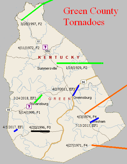
January 18, 1929
Counties: Green, Taylor
F-scale: F2
Deaths: 2
Injuries: 5
Path width: 100 yards
Path length: 12 miles
Time: 4:00pm
Narrative: Moved east from near Summersville to near Campbellsville. The deaths were in a home near the county line.
April 27, 1971
Counties: Green, Adair
F-scale: F4
Deaths: 6
Injuries: 58
Path width: 100 yards
Path length: 15 miles
Time: 9:30pm CDT
Notes: Moved east-southeast from Bramlett, passing three miles northeast of Columbia, to Vester and Christine. Six people were killed when the tornado demolished a number of homes in the Mount Pleasant Church area on KY 551. The church itself was leveled. A total of 51 homes, 33 barns, three churches, four trailers, and 100 other buildings were destroyed, and fifty more homes had major damage.
Noted discrepancies: SPC and NCDC give a path length of 14 miles, Grazulis and Storm Data give 15.
April 11, 1972
Counties: Green
F-scale: F2
Deaths: 0
Injuries: 0
Path width:
Path length:
Time: 11:45pm
Grazulis narrative: Near Allendale three trailers and three barns were destroyed in a brief touchdown. A frame home was damaged.
Noted discrepancies: SPC gives a path length of 1/10 of a mile and a path width of 10 yards...NCDC and Grazulis give nothing for either.
April 3, 1974
Counties: Green, Taylor
F-scale: F4
Deaths: 0
Injuries: 56
Path width: 800 yards
Path length:
Time: 4:40pm
Grazulis narrative: Moved northeast from south of Greensburg to Mannsville, destroying a large part of that town. About 50 homes and 60 barns were destroyed, and 40 of those were at Mannsville, with seven of them leveled to the ground.
Noted discrepancies: SPC and NCDC give a time of 4:40pm, Grazulis and Storm Data give 5:40pm. SPC gives a path length of 20 miles...NCDC gives 21 miles...Grazulis give 29 miles. SPC gives a path width of 10 yards...NCDC 30 yards...Grazulis 800 yards. Grazulis' width is probably most correct.
Notes: Storm Data says this tornado hit Mannsville, Burdick, Meadow Creek, and White Ridge.
May 14, 1995
Counties: Green
F-scale: F1
Deaths:
Injuries:
Path width:
Path length:
Time: 10:15pm
Notes: Storm Data puts this tornado at Donansburg.
April 20 1996
Counties: Green
F-scale: F0
Deaths:
Injuries:
Path width:
Path length:
Time: 2:45am
Notes: Storm Data mentions damage between US 68 and Russell Creek.
March 28, 1997
Counties: Green, LaRue, Marion
F-scale: F2
Deaths:
Injuries:
Path width:
Path length:
Time: 6:25pm
Notes: Storm Data says this tornado touched down in Creal, crossed KY 61, KY 2762, KY 210, entered LaRue County, hit Pleasant Ridge, entered Marion County, dissipating three miles west of Saint Joseph. Cannot find Creal on any map.
April 27, 2011
Counties: Green
EF-Scale: EF-1
Deaths: 0
Injuries: 0
Path width: 150 yards
Path length: 2.8 miles
Time: 6:32am CDT
Notes: Numerous windows and chimneys were damaged in downtown Greensburg. Trees were snapped and uprooted along US 68 throughout the path. Greensburg's industrial park suffered the worst damage when a brick building suffered exterior and interior damage. North of Bluff Boom Road the tornado significantly damaged a mobile home and destroyed two barns.
July 13, 2015
County: Green
EF-Scale: EF1
Deaths: 0
Injuries: 0
Path width: 50 yards
Path length: 1.1 miles
Time: 5:20pm - 5:22pm CDT
Notes: The highest winds with this tornado were estimated to have been 95 to 105 mph. The tornado destroyed two barns and one mobile home in addition to doing considerable roof damage to six outbuildings along Ebenezer Road and KY 61 southeast of Greensburg.
April 5, 2017
County: Green
EF-Scale: EF1
Deaths: 0
Injuries: 0
Path width: 250 yards
Path length: 0.8 mile
Time: 5:16pm - 5:17pm CDT
Notes: This tornado touched down in an open field and headed northeast toward Mahogany Lane. Two small vortices, one 50 yards wide and the other 100 yards wide, reached speeds of 105 mph as they destroyed a large, well-built barn and two smaller outbuildings in addition to a fifth-wheel trailer. The debris was blown up to 0.25 mile to the northeast and exhibited both convergence and rotation.
February 24, 2018
County: Green
EF-Scale: EF2
Deaths: 0
Injuries: 0
Path width: 100 yards
Path length: 1.3 miles
Time: 10:33pm - 10:35pm CST
Notes: This tornado began by causing roof damage to two barns and destroying two other barns. One, on the left side of the path, was shifted south, and the other, to the right of the path, was shifted north. Tall grass along a fence line within the tornado's path showed evidence of convergence. Also, a large tree on the north side of the path was snapped southward and drug 10 feet to the south. Heading east, the tornado felled several trees. A detached garage had its door bow out. Next, a 2-story house had some roof damage and a porch on the lee side of the house had a column fly out and land in a field 50 yards away. Lastly, the tornado struck a barn and several trees. A carport was thrown over a house and landed 100 yards to the east.


 Weather Story
 Weather Map
 Local Radar