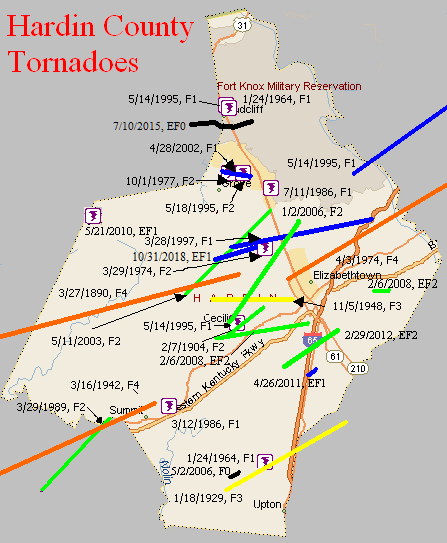
March 27, 1890
Counties: Ohio, Grayson, Breckinridge, Hardin
F-scale: F4
Deaths: 7
Injuries: 40
Path width: 1200 yards
Path length: 60 miles (probably a family of tornadoes)
Time: 8:00pm
Narrative: Moved east-northeast from seven miles northwest of Hartford. Many miles of forest were leveled, and small farm communities were wiped out. Homes were said to have "vanished" near Sulphur Springs (where two people were killed) and near Falls of Rough (where three people were killed). The last damage was near Rineyville, where two people were killed in one home.
February 7, 1904
Counties: Hardin
F-scale: F2
Deaths: 0
Injuries:
Path width: 250 yards
Path length: 3 miles
Time: 4:25am
Narrative: Moved northeast along the southeast edge of Cecilia. A "substantial" brick church was leveled, as were many barns. Homes were unroofed. Trees pointed in towards the center on both sides of the track.
January 18, 1929
Counties: Hardin, LaRue
F-scale: F3
Deaths: 1
Injuries: 5
Path width: 800 yards
Path length: 10 miles
Time: 4:00pm
Narrative: One "substantial" home and four barns were destroyed as a tornado moved northeast at Sonora. Many other buildings were damaged. This day's wind damage throughout the state of Kentucky totalled $1,000,000.
March 16, 1942
Counties: Grayson, Hardin
F-scale: F4
Deaths: 9
Injuries: 40
Path width: 200 yards
Path length: 30 miles
Time: 6:15pm
Narrative: Moved east-northeast from north of Caneyville to near Summit. People died in seven different homes north of Caneyville, Millwood, Leitchfield, Clarkson, and Summit. About twenty homes were destroyed, and some were swept completely away. Two of the deaths were in Hardin County.
November 5, 1948
Counties: Hardin
F-scale: F3
Deaths: 1
Injuries: 2
Path width: 50 yards
Path length: 6 miles
Time: 5:45am
Notes: Wind damage occurred in a five mile wide swath from Howe Valley to three miles east of Elizabethtown. Within this area of high winds, an F3 tornado swept from about two miles northwest of Cecelia to three miles east of Elizabethtown. The worst of the tornado took place at its inception on Bethlehem Academy Road, where a barn was destroyed killing a woman inside. A nearby house was lifted bodily from its foundation, power lines were torn down, and a white leghorn rooster was stripped of its feathers. Trees were blown down in Saint John. Proceeding further to the east, power lines were downed on Old Cecilia Road and a barn was destroyed on Saint John Road three miles west of Elizabethtown. The tornado then weakened considerably, and the only significant damage done in Elizabethtown was power lines getting ripped down on North Dixie Highway. Leaving town, the tornado restrengthened and demolished a barn and a nearby house, and unroofed several homes three miles from Elizabethtown on US 62, where the twister grew to a quarter mile wide. However it dissipated soon thereafter. Straight-line winds tore down trees and power poles and damaged barns at Howe Valley, Franklin Cross Roads, Cecilia, Patterson, Tabb (four miles west of Elizabethtown on US 62), Glendale, Sonora, and on Springfield Road three miles east of Elizabethtown.
January 24, 1964
Counties: Hardin
F-scale: F1
Deaths:
Injuries:
Path width:
Path length:
Time: 9:00pm
Notes: One to two miles west of Sonora a large barn with corrugated iron siding was completely torn from its foundation, with corrugated iron sheets extending about 0.25 mile across two fields. A 12" diameter oak tree was twisted off in the center of the damage path. Definite indication of rotary motion in the damage path according to the Louisville Weather Bureau surveyor. Two other barns were damaged though not destroyed.
Noted discrepancies: SPC gives a path width of 10 yards and a path length of 1/10 of a mile...NCDC gives nothing for either. The only Kentucky event on this day in Storm Data is in Fulton County because the report for this tornado came in too late for inclusion in the publication.
January 24, 1964
Counties: Hardin
F-scale: F1
Deaths:
Injuries:
Path width:
Path length:
Time: 9:45pmNotes: Manager of radio station WIEL relayed a report of considerable damage, with indications of a circular patter in the debris, at the rear of an athletic field at a dependent school.
Noted discrepancies: SPC gives a path width of 10 yards and a path length of 1/10 of a mile...NCDC gives nothing for either. The only Kentucky event on this day in Storm Data is in Fulton County because the report for this tornado came in too late for inclusion in the publication. The SPC/NCDC lat/lon pairs actually put this tornado in Meade County. There was minor tree damage in Meade County, but so far this project has been unable to find any documentation of a tornado there.
March 29, 1974
Counties: Hardin
F-scale: F2
Deaths:
Injuries: 8
Path width:
Path length:
Time: 6:45pm
Noted discrepancies: SPC/NCDC list this as an F2, Grazulis does not list it.
April 3, 1974
Counties: Hardin, Nelson, Spencer
F-scale: F4
Deaths: 3
Injuries: 81
Path width: 400 yards
Path length: 40 miles
Time: 3:45pm
Eyewitness narrative: I was 15 years old at the time and I lived on KY 44 just east of Elk Creek in Spencer County. The storm came up from near Cox's Creek where the Whitney Horse Farm was damaged, crossing Lilly Pike where several homes, barns, and trailers were demolished, across Murray Road, and then across KY 44 and on to the Elk Creek community. On Murray Road a father and son were in their milking barn when they saw the storm approach. They got under some heavy equipment for shelter and the barn came down around them. They were rescued several hours later as workers and neighbors cleared Murray Road of trees and debris. The father was taken to the hospital in critical condition but the son was OK. As the twister crossed Murray Road and Elk Creek it was about 300 yards wide. The tornado broke into vortices at my home on KY 44 and circled around the house. Our neighbors between us and the creek lost their roof, which landed 300 yards to the east of their home mostly intact. Witnesses said that the main tornado broke into two vortices, the larger one of which hit the house to our west while the other went to the east and damaged a farm on Carl Monroe Road just south of KY 44. My home was in between the two vortices and was spared. The two vortices came together on the north side of KY 44 across from my house and destroyed a large tobacco barn. Debris from the barn could be seen circling the tornado and was thrown to the southeast. I saw the tornado start to rope out at this point. It touched down again in Elk Creek but didn't do much more damage.
Grazulis narrative: Moved northeast from northwest of Elizabethtown, destroying businesses as it passed two miles north of that town along the miracle mile strip on US 31W. Two people were killed in this area. One person was killed as 15 homes were destroyed near Cox's Creek, Nelson County. The funnel lifted two miles north of Fairfield. Nelson County lost 52 homes and about 100 barns.
Noted discrepancies: Grazulis takes this tornado into Bullitt County as well. The path Grazulis describes seems to keep the tornado just barely inside Nelson County, though it does indeed come very close to the Bullitt County line. Grazulis lifts the tornado two miles north of Fairfield, but SPC/NCDC take it to north of Wakefield. Storm Data may begin this tornado at Colesburg in Hardin County...then it reports continuous damage from 3 miles north of Boston to Samuels to 2 miles north of Fairfield. Storm Data lists Hardin, Nelson, and Spencer counties. SPC/NCDC give a path length of 38 miles, Grazulis gives 42 miles. SPC gives a path width of 10 yards, NCDC 30 yards, Grazulis 400 yards. Grazulis' path width is probably the most correct.
October 1, 1977
Counties: Hardin
F-scale: F2
Deaths: 0
Injuries: 0
Path width: 30 yards
Path length: 2 miles
Time: 4:00pm
Grazulis narrative: A new brick home was destroyed and the neighboring home was unroofed in a brief touchdown in Radcliff.
Noted discrepancies: SPC and NCDC list this as an F2, Grazulis calls it an F3. SPC and NCDC time it at 4:00pm, Grazulis and Storm Data 6:00pm. SPC, Grazulis, and NCDC list the path width at 30 yards, Storm Data says 1 yard.
March 12, 1986
Counties: Hardin
F-scale: F1
Deaths:
Injuries:
Path width:
Path length:
Time: 4:40am
Notes: Storm Data touches this tornado down at Eastview and hits KY 84.
July 11, 1986
Counties: Hardin
F-scale: F1
Deaths:
Injuries: 1
Path width:
Path length:
Time: 9:00pm
Noted discrepancies: Storm Data mentions damage on Black Jack Road in southeast Radcliff.
May 14, 1995
Counties: Hardin, Bullitt
F-scale: F1
Deaths: 0
Injuries: 0
Path width: 200 yards
Path length: 15 miles
Time: 12:35am
Grazulis narrative: An intermittent tornado downed and snapped trees in varying direction with "twisting" evident. One roof was damaged near Lebanon Junction.
Noted discrepancies: SPC lists this as an F2, NCDC and Grazulis list it as an F1. Storm Data says "F1 or F2". Will plot it as an F1.
May 14, 1995
Counties: Hardin
F-scale: F1
Deaths:
Injuries:
Path width:
Path length:
Time: 12:48am
Noted discrepancies: NCDC and Storm Data give no F-scale rating for this tornado.
Notes: Storm Data puts this tornado at Fort Knox.
May 14, 1995
Counties: Hardin
F-scale: F1
Deaths:
Injuries:
Path width:
Path length:
Time: 1:25pm
Notes: Storm Data puts this tornado at Cecilia.
May 18, 1995
Counties: Hardin
F-scale: F2
Deaths: 0
Injuries: 0
Path width: 200 yards
Path length: 1/2 mile
Time: 5:15pm
Grazulis narrative: A tornado was sighted at Fort Knox, northeast of Radcliff. Several buildings were damaged.
Noted discrepancies: NWS ranks this as an F2, Grazulis says F1. Grazulis lists this tornado at 6:15pm.
March 28, 1997
Counties: Hardin
F-scale: F1
Deaths:
Injuries:
Path width:
Path length:
Time: 5:45pm
Noted discrepancies: Storm Data takes this tornado from Rineyville to Colesburg.
April 28, 2002
Counties: Hardin
F-scale: F1
Deaths:
Injuries:
Path width:
Path length:
Time: 2:55am
Noted discrepancies: SPC lists a path width of 20 yards, NCDC and Storm Data says 50 yards.
Notes: Storm Data takes this tornado from two miles west of Radcliff to Radcliff.
May 11, 2003
Counties: Hardin
F-scale: F2
Deaths:
Injuries: 5
Path width:
Path length:
Time: 3:10am
Notes: Storm Data says this tornado formed three and a half miles southwest of Rineyville on KY 1375, went through Rineyville, and lifted three miles northeast of Rineyville.
January 2, 2006
Counties: Hardin
F-scale: F2
Deaths: 0
Injuries: 0
Path width: 150 yards
Path length: 8 miles
Time: 2:43pm
Notes: This tornado touched down near Cecilia, blowing the roof off a barn, but only producing shingle damage on nearby residences. It did more damage when it reached Saint John Road, where it destroyed a home and some farm buildings. As the tornado continued to the northeast, it produced major roof damage to homes along Rineyville Road. Next, an office building that was under construction was lifted off of its foundation. A convenience store was destroyed along US 31W. A few more homes received minor damage before the tornado lifted near Longview.
May 2, 2006
Counties: Hardin
F-scale: F0
Deaths: 0
Injuries: 0
Path width: 50 yards
Path length: 0.7 miles
Time: 4:35am
Notes: Tree damage.
February 6, 2008
Counties: Hardin
EF-scale: EF2
Deaths: 0
Injuries: 0
Path width: 400 yards
Path length: 7.1 miles
Time: 12:21am EST to 12:25am EST
Notes: The tornado destroyed a trailer and an outbuilding along Hansborough Road. It caused major roof damage along Bethlehem Academy Road, with one home losing the roof completely. Several boats were flipped over, and a large bus was pushed two feet. The tornado pushed in garage doors at an industrial building along Ring Road. This building also suffered significant roof damage. At Central Hardin High School the tornado snapped concrete pillar stadium lights at the football stadium. The press box was thrown onto the playing field and destroyed. The basketball gym and a wing of the school experienced roof damage. Along Black Branch Road just east of the school complex the tornado caused some structural damage to homes.
February 6, 2008
Counties: Hardin
EF-scale: EF2
Deaths: 0
Injuries: 0
Path width: 300 yards
Path length: 1.2 miles
Time: 12:27am EST to 12:29am EST
Notes: This tornado knocked a trailer off its foundation at the intersection of Miller Road and Porter Lane. Another trailer near this location was completely destroyed. Another trailer along Miller Road was turned on to its roof.
May 21, 2010
Counties: Breckinridge, Hardin
F-scale: EF1
Deaths: 0
Injuries: 0
Path width: 75 yards
Path length: 1.75 mile
Time: 7:28pm CDT/8:28pm EDT
Narrative: A barn was significantly damaged west of Big Spring, and a mobile home was partially unroofed southeast of Big Spring. There was also some tree damage.
April 26, 2011
Counties: Hardin
EF-Scale: EF-1
Deaths: 0
Injuries: 0
Path width: 125 yards
Path length: 0.7 mile
Time: 8:53pm EDT
Notes: The tornado formed just west of Interstate 65 and crossed the highway, the Hardin County Fairgrounds, and lifted just east of the intersection of First Union Church Road and Sportsman Lake Road. On the fairgrounds the tornado struck a large livestock barn as well as the fairgrounds' restaurant. The roof of the restaurant was thrown westward on top of a livestock barn. Metal siding was thrown 250 yards and several trees were snapped and uprooted. Near the end of the path there was roof damage to a one story house as well as downed power lines.
February 29, 2012
County: Hardin
EF-Scale: EF-2
Deaths: 0
Injuries: 0
Path width: 250 yards
Path length: 5 miles
Time: 9:55am EST
Notes: The tornado began as a 125 yard tornado near 4510 Gather Station Road damaging a barn and traveled towards New Glendale Road and Overall Phillips Road damaging some homes and knocking down many trees and fences. The storm crossed I 65 and surprisingly did not strike any vehicles. The twister struck several homes lifting many roof structures off of Wildwood Drive and Sportmans Lake Road. It increased in width to 250 yards and struck the Harry Owen trucking company buckling roof trusses and spreading significant debris over the Lincoln Parkway into the mobile home park. Next it destroyed a working garage and did significant damage to 3 homes off of Hodgenville Road and uprooting and twisting many trees before lifting a couple of hundred yards downwind.
July 10, 2015
County: Meade, Hardin
EF-Scale: EF0
Deaths: 0
Injuries: 0
Path width: 100 yards
Path length: 3.2 miles
Time: 10:35am - 10:41am EDT
Notes: A weak, skipping tornado occurred on Fort Knox. The tornado first touched down near the intersection of Lee Road and Fort Avenue just west of the military base's boundary. It traveled east over forested land, doing occasional damage to trees before it passed into Hardin County, 0.7 miles WSW of the U.S. Bullion Depository. It continued east for approximately 0.5 miles, then turned northeast over the PX and commissary complex before lifting 0.6 miles ENE of the base high school near Wilson Road. Several large hackberry and oak trees were uprooted and snapped between the PX and Scott Middle School. There was also some shingle damage to some of the buildings near the high school track. The tornado also caused significant tree damage from the middle school north/northeast across a remote area of the northeast part of the post.
October 31, 2018
County: Hardin
EF-Scale: EF1
Deaths: 0
Injuries: 0
Path width: 80 yards
Path length: 2.5 miles
Time: 5:39pm - 5:43pm EDT
Notes: This brief, skipping tornado touched down initially as an EF0 near the east end of Labrador Way in a subdivision 1.5 miles south of Rineyville Elementary School. It did minor roof damage to two homes, tossed a trampoline into a neighboring home, causing siding damage, and pushed a large travel trailer onto a minivan, heavily damaging both. Mud was spattered onto the north-facing front of the home, where a porch column support was also moved slightly. From here it travelled east-northeast, snapping tree limbs as it skipped over mainly open pastureland until it reached Thomas Road. On the west side of Thomas Road, the tornado reached its greatest intensity and size, with winds of 100 mph. Here it damaged four outbuildings, completely destroying two - the largest being a 30 x 50 structure. The debris pattern from the four outbuildings and nearby trees with snapped trunks and limbs showed clear cyclonic rotation. Metal roofing and siding material were scattered nearly a quarter of a mile to the east-northeast, with some of it lofted into the trees of a heavily wooded area. Other building debris from the largest structure was blown to the northwest, and the south and east-facing walls of a number of structures were spattered with leaves and other ground-based vegetation. Three east-facing garage doors of one of the outbuildings were blown in, and damage was sustained to the vehicles in the driveway from downed tree limbs. Three homes in the area sustained roof and siding damage, including a 2x4 from one of the outbuildings blown through an exterior wall. The tornado became elevated as it continued east-northeast from Thomas Road, snapping a few tree limbs in a wooded area before briefly touching down one last time on Rineyville Road, where it littered the highway with tree limbs and tore the front porch off a home, vaulting the roof over the house into the back yard. Security cameras from a business next door captured the damage occurring as a wall of wind and water that occurred in less than half a minute. No further damage occurred to the east of this location as the tornado dissipated.


 Weather Story
 Weather Map
 Local Radar