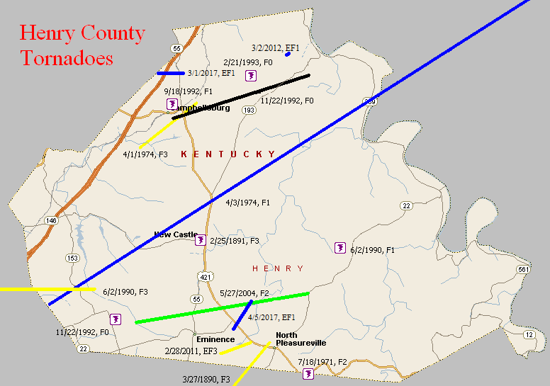
March 27, 1890
Counties: Shelby, Henry
F-scale: F3
Deaths: 3
Injuries: 10
Path width: 150 yards
Path length: 5 miles
Time: 8:15pm
Narrative: Moved northeast from four miles south of Eminence, passing one mile north of Pleasureville. Four farm houses were destroyed, and three members of a family were killed in one of them.
February 25, 1891
Counties: Henry
F-scale: F3
Deaths: 2
Injuries: 15
Path width:
Path length:
Time: 1:00am
Narrative: Homes of all sizes were destroyed near New Castle. Barn timbers were carried a mile. Cattle and horses were killed.
March 25, 1964
Counties: Jefferson KY, Shelby, Oldham, Henry
F-scale: F2
Deaths: 0
Injuries: 1
Path width: 30 yards
Path length:
Time: 7:00pm
Grazulis narrative: Skipped east-northeast from just east of Standiford Field to Smithfield and New Castle. The "bounding" tornado, and accompanying high winds, unroofed or damaged four homes, 31 barns, and fifty other buildings.
Jefferson County: The Jefferson County portion of the track was well-covered in the local newspapers. The tornado touched down on the east side of Louisville International Airport at the intersection of Standiford Lane and Preston Highway, where it lifted and blew a car 40 feet, depositing it on its roof. The tornado grew to about two blocks wide and tore the roof off of a home at 4503 Zeta Court, dropping it in the back yard. Also on Zeta Court a car was flipped over. At about the same time a truck was flipped over at 2420 Cavelle Avenue. The tornado may have weakened or lifted slightly as the storm moved through Watterson Park and West Buechel. Damage then occurred again when a frame home's garage was torn from its foundation at 2835 Klondike Lane and was thrown 100 feet into the side of Saint Martha Catholic Church. On Dale Ann Drive a playhouse weighing 1500 pounds was blown 200 feet. After causing comparatively little damage in Houston Acres, the tornado strengthened again and grew to a width of about three blocks. On Cardwell Way a carport collapsed, three homes were damaged, and a car was demolished. Meanwhile, siding was removed from a home at 58 Hallsdale Drive and a garage was destroyed next door at 60 Hallsdale Drive. The tornado may have again weakened or lifted as the storm crossed Blue Ridge Manor and Anchorage. The last damage report in Jefferson County was on Collins Lane where homes and commercial buildings were damaged, and roofs were removed from barns. The head of the weather service office in Louisville, O. K. Anderson, surveyed the damage and said there was no doubt in his mind that it was a small, bounding tornado. Click here for a map of the Jefferson County portion of this tornado track. Louisville newspapers did not mention any damage in Oldham or Shelby Counties. There was mention of tornado damage in Smithfield and just outside New Castle in Henry County.
Noted discrepancies: Grazulis does not include Shelby County. NCDC does not list Oldham County or Henry County, and lists Jefferson County twice. Storm Data lists only Jefferson and Henry counties. SPC, Storm Data, and NCDC give a time of 7:00pm, Grazulis give 7:25pm. SPC gives and endpoint lat/lon of 28.50/-85.12...NCDC give 38.22/-85.45. SPC, Storm Data, and NCDC list one injury...Grazulis lists none. SPC gives a path length of 38 miles, NCDC gives 33 miles, Storm Data says 40 miles, Grazulis lists a skipping path of 23 miles. SPC gives a path width of 10 yards, NCDC 30 yards, Grazulis 40 yards. The second of the two Jefferson County entries at NCDC lists the touchdown point with the exact same lat/lon as the liftoff point in the first Jefferson County entry. Grazulis does mention that the tornado skipped. The NCDC touchdown lat/lon in Shelby County is not the same as the liftoff lat/lon in Jefferson County, though it ought to be if the tornado went directly from Jefferson County into Shelby County as one coherent tornado, so perhaps at the NCDC website the Shelby County event is a separate tornado, and is also a separate tornado according to Grazulis who perhaps felt it was not F2 and thus omitted it...? Grazulis takes the twister from Jefferson County into Oldham County (instead of Shelby County) and on into Henry County (agreeing with SPC's database). The touchdown and liftoff lat/lon given by SPC/NCDC agree perfectly with Grazulis. Using the touchdown and liftoff lat/lons at SPC, this tornado would have missed Shelby County. The end lat/lon given by NCDC for Shelby County is actually located in Henry County. Storm Data narrative says, "A small tornado of the bounding type moved in a straight line west-southwest to east-northeast from about half a mile east of Standiford Field...to approximately ten miles northeast. Apparently the same tornado continued northeastward into Henry County. It touched down several times in Jefferson County, and in Henry County...in the vicinities of Smithfield and New Castle." More research is necessary.
July 18, 1971
Counties: Henry, Shelby
F-scale: F2
Deaths:
Injuries:
Path width:
Path length:
Time: 2:15pm
Grazulis narrative: In the Pleasureville-Defoe area a tornado destroyed three barns and a silo.
Noted discrepancies: NCDC and Grazulis only list Henry County. The single lat/lon SPC gives is indeed in Shelby County, but very close to the county line. SPC gives a path length of 1/10 of a mile and a path width of 10 yards...NCDC and Grazulis give nothing for either. Both places of damage listed by Grazulis are on the Henry/Shelby county line. Using damage locations listed by Grazulis the path length might have been longer than the 1/10 mile given by SPC. Storm Data says the tornado touched down between Pleasureville and Defoe and almost immediately lifted back into the clouds. Storm Data lists both Shelby and Henry counties.
April 1, 1974
Counties: Henry
F-scale: F3
Deaths: 1
Injuries: 20
Path width: 300 yards
Path length: 3 miles
Time: 6:20pm
Grazulis narrative: About 100 of the 500 residents of Campbellsburg were left homeless. Nineteen homes and 23 businesses were destroyed or damaged.
Noted discrepancies: SPC and NCDC list this as an F3, Grazulis calls it an F2.
April 3, 1974
Counties: Henry (to Owen)
F-scale: F1
Deaths: 0
Injuries: 18
Path width: 30 yards
Path length: 32 miles
Time: 4:15pm
Noted discrepancies: SPC gives a path length of 32 miles, NCDC 31 miles. SPC gives a path width of 10 yards, NCDC 30 yards.
June 2, 1990
Counties: Oldham, Henry
F-scale: F3
Deaths: 0
Injuries: 5
Path width: 75 yards
Path length: 10 miles
Time: 10:30pm
Grazulis narrative: Moved east from just east of Goshen, passing one mile north of Lagrange, and through Jericho. At the edge of Lagrange three frame homes and three mobile homes were destroyed. A dozen other homes were damaged.
Noted discrepancies: SPC and NCDC give a path length of 10 miles, Grazulis give 9 miles. A straight line between SPC's touchdown and liftoff points doesn't quite fit with the description given by Grazulis (which agrees with Storm Data). Adjusted track here to agree with Storm Data/Grazulis. Grazulis times this tornado at 11:30pm.
June 2, 1990
Counties: Henry
F-scale: F1
Deaths:
Injuries:
Path width:
Path length:
Time: 10:55pm
Notes: Storm Data says this tornado struck just south of Franklinton.
September 18, 1992
Counties: Henry
F-scale: F1
Deaths:
Injuries:
Path width:
Path length:
Time: 4:25pm
Noted discrepancies: SPC gives a time of 4:25pm, NCDC gives 3:25pm.
November 22, 1992
Counties: Henry
F-scale: F0
Deaths:
Injuries:
Path width:
Path length:
Time: 3:20pm
Noted discrepancies: SPC gives a time of 3:20pm, NCDC 2:20pm, Storm Data 4:20pm.
Notes: Storm Data says this tornado struck the north edge of Smithfield.
November 22, 1992
Counties: Henry
F-scale: F0
Deaths:
Injuries:
Path width:
Path length:
Time: 3:40pm
Noted discrepancies: SPC gives a time of 3:40pm, NCDC says 2:40pm, Storm Data says 4:40pm.
Notes: Storm Data says this tornado touched down just north of Campbellsburg, then northeast of Tucker Station, then near Port Royal near the Carroll County line.
February 21, 1993
Counties: Henry
F-scale: F0
Deaths:
Injuries:
Path width:
Path length:
Time: 3:50pm
Noted discrepancies: Storm Data says this tornado touched down near Port Royal.
May 27, 2004
Counties: Henry
F-scale: F2
Deaths:
Injuries: 2
Path width:
Path length:
Time: 6:50pm
Notes: Storm Data takes this tornado from one mile east of Smithfield to five miles east-northeast of Eminence. It crossed KY 55 north of Eminence. It moved between US 421 and Eminence-Point Pleasant Road. It then crossed Sweeney Lane.
February 28, 2011
Counties: Henry
F-scale: EF3
Deaths: 0
Injuries: 1
Path width: 150 yards
Path length: 2.3 miles
Time: 4:59am
Notes: The tornado touched down just to the southwest of KY 1899 (Mulberry Pike), crossing into Springhill Estates subdivision. Two homes were destroyed here along with three outbuildings. Trees were uprooted and snapped. The tornado then weakened as it traveled across KY 1359. Fifteen power poles were blown down along the highway. One barn was destroyed and another had the roof blown off. The tornado continued across KY 22 where trees were blown down and one outbuilding was damaged. The tornado lifted near Drennon Creek.
March 2, 2012
Counties: Henry
EF-Scale: EF-1
Deaths: 0
Injuries: 0
Path width: 40 yards
Path length: 0.25 mile
Time: 4:12pm EST
Notes: The National Weather Service in conjunction with an aerial damage survey performed by pilots David Katz and Gary Katz and photographer Tom Boucher from the Kentuckiana Volunteer Aviators determined that an EF-1 tornado touched down in northern Henry county on Friday, March 2nd. A thin path of downed trees coincident with a circulation observed on radar was surveyed by the pilots. Numerous trees were uprooted near a pasture east of Port Royal-English Road.
March 1, 2017
County: Henry
EF-Scale: EF1
Deaths: 0
Injuries: 0
Path width: 200 yards
Path length: 1.1 miles
Time: 6:36am - 6:38am EST
Notes: Touchdown was two miles north of Campbellsburg. It crossed Interstate 71 where it overturned a truck, and lifted 2.2 miles northeast of Campbellsburg. The most significant damage occurred on Jones Lane where 100 mph winds destroyed two large barns along with small outbuildings. A large grain bin was demolished and an anchored mobile home was pushed off of its foundation. A large debris field was scattered 200-300 yards downwind. East of I-71 the tornado damaged outbuildings and snapped trees. After destroying an older barn, the tornado ended just east of KY 55 where numerous softwood trees were snapped and uprooted. Very strong convergence was noted in the damage.
April 5, 2017
County: Henry
EF-Scale: EF1
Deaths: 0
Injuries: 0
Path width: 100 yards
Path length: 1.7 mile
Time: 5:54pm - 5:56pm EDT
Notes:The first evidence of tornado damage was just south of US 421 where the tornado passed between two farms. Barns on either side of the path were damaged with the debris thrown clockwise, showing an anticyclonic rotation. The tornado crossed US 421 and continued northeast. The last evidence of a tornado was at a house on Point Pleasant Road where the tornado blew in a garage door.


 Weather Story
 Weather Map
 Local Radar
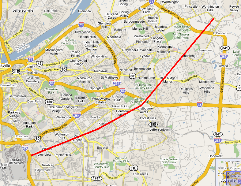