
Severe thunderstorms will continue to be possible over parts of the northern Plains and upper Midwest through Saturday which could bring large hail, damaging winds, and possible tornadoes. Heavy to excessive rainfall may produce flooding over a part of the Midwest today. Elevated to critical fire weather are expected today into this weekend over parts of the central Rockies and Great Basin. Read More >
Louisville, KY
Weather Forecast Office
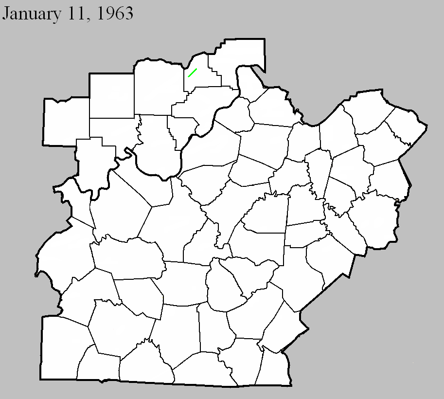
January 11, 1963
Counties: Scott IN
F-scale: F2
Deaths: 0
Injuries: 0
Path width: 150 yards
Path length:
Time: 11:35pm
Grazulis narrative: Moved northeast from three miles north of Scottsburg. Several homes and barns were damaged or destroyed.
Noted discrepancies: SPC and NCDC rank this as an F2, Grazulis calls it an F3. SPC/NCDC begin the tornado west of Scottsburg...Grazulis starts it north of Scottsburg. SPC/NCDC stop the tornado where Grazulis starts it (Grazulis then moves it northeast for 5 miles). Storm Data says the tornado moved northeast and crossed I-65 three miles north of Scottsburg.
Current Hazards
Hazardous Weather Outlook
Storm Prediction Center
Submit a Storm Report
Advisory/Warning Criteria
Radar
Fort Knox
Evansville
Fort Campbell
Nashville
Jackson
Wilmington
Latest Forecasts
El Nino and La Nina
Climate Prediction
Central U.S. Weather Stories
1-Stop Winter Forecast
Aviation
IDSS Forecast Points
Air Quality
Fire Weather
Recreation Forecasts
1-Stop Drought
Event Ready
1-Stop Severe Forecast
Past Weather
Climate Graphs
1-Stop Climate
CoCoRaHS
Local Climate Pages
Tornado History
Past Derby/Oaks/Thunder Weather
Football Weather
Local Information
About the NWS
Forecast Discussion
Items of Interest
Spotter Training
Regional Weather Map
Decision Support Page
Text Products
Science and Technology
Outreach
LMK Warning Area
About Our Office
Station History
Hazardous Weather Outlook
Local Climate Page
Tornado Machine Plans
Weather Enterprise Resources
US Dept of Commerce
National Oceanic and Atmospheric Administration
National Weather Service
Louisville, KY
6201 Theiler Lane
Louisville, KY 40229-1476
502-969-8842
Comments? Questions? Please Contact Us.


 Weather Story
 Weather Map
 Local Radar