
A storm system will bring a number impacts to the central and eastern US. Heavy rain and thunderstorms are expected in the Gulf Coast and Deep South. Further north, a wintry mix may produce a glaze of ice from the Ozarks/Mid-South east through the Ohio Valley. Accumulating snow is expected from the central Plains east into the Upper Ohio Valley/Lower Great Lakes. Read More >
Louisville, KY
Weather Forecast Office
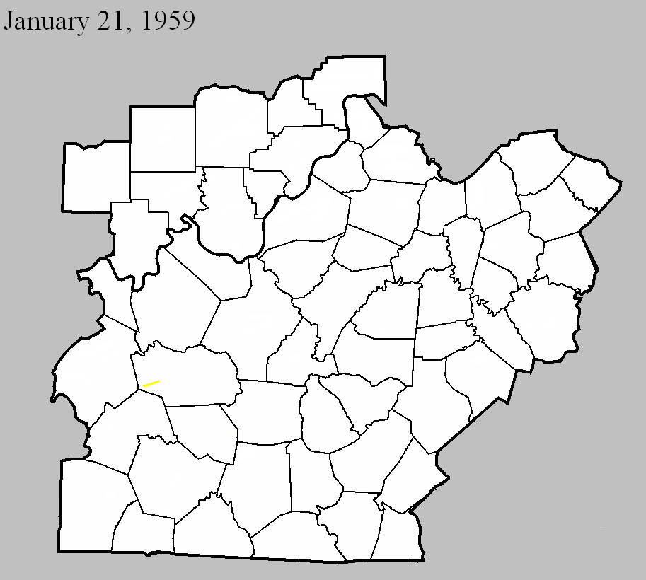
January 21, 1959
Counties: Grayson
F-scale: F3
Deaths: 3
Injuries: 5
Path width: 100 yards
Path length: 7 miles
Time: 12:30pm
Grazulis Narrative: Moved northeast in and near Neafus, Steff, Spring Lick, Goffs, Short Creek, Staff, and Caneyville. Four homes were destroyed in Neafus, and two each in Steff and Spring Lick. Ten buildings were destroyed on a farm.
Noted discrepancies: SPC, Storm Data, and NCDC list no injuries, but Grazulis lists 5. SPC gives a path width of 10 yards, NCDC 30 yards, Grazulis 100 yards.
Current Hazards
Hazardous Weather Outlook
Storm Prediction Center
Submit a Storm Report
Advisory/Warning Criteria
Radar
Fort Knox
Evansville
Fort Campbell
Nashville
Jackson
Wilmington
Latest Forecasts
El Nino and La Nina
Climate Prediction
Central U.S. Weather Stories
1-Stop Winter Forecast
Aviation
Spot Request
Air Quality
Fire Weather
Recreation Forecasts
1-Stop Drought
Event Ready
1-Stop Severe Forecast
Past Weather
Climate Graphs
1-Stop Climate
CoCoRaHS
Local Climate Pages
Tornado History
Past Derby/Oaks/Thunder Weather
Football Weather
Local Information
About the NWS
Forecast Discussion
Items of Interest
Spotter Training
Regional Weather Map
Decision Support Page
Text Products
Science and Technology
Outreach
LMK Warning Area
About Our Office
Station History
Hazardous Weather Outlook
Local Climate Page
Tornado Machine Plans
Weather Enterprise Resources
US Dept of Commerce
National Oceanic and Atmospheric Administration
National Weather Service
Louisville, KY
6201 Theiler Lane
Louisville, KY 40229-1476
502-969-8842
Comments? Questions? Please Contact Us.


 Weather Story
 Weather Map
 Local Radar