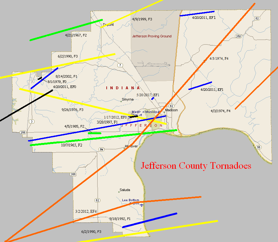
October 7, 1965
Counties: Jefferson IN
F-scale: F2
Deaths:
Injuries:
Path width:
Path length:
Time: 6:00pm
Noted discrepancies: SPC and NCDC list this as an F2...Grazulis does not list it.
Notes: Storm Data says this tornado touched down one mile west of Kent and moved east for two miles.
April 21, 1967
Counties: Jefferson IN (from Jennings)
F-scale: F2
Deaths: 0
Injuries: 2
Path width:
Path length: 6 miles
Time: 5:10pm
Grazulis narrative: Moved east from Commiskey to Dupont. Two homes were unroofed and torn apart, injuring two people inside one of them. A trailer was demolished, and farm buildings were destroyed.
Noted discrepancies: SPC and NCDC give a path length of 6 miles, Grazulis gives 7. SPC gives a path width of 10 yards, NCDC 30 yards, Grazulis nothing.
April 3, 1974
Counties: Clark IN, Scott IN, Jefferson IN (to Ripley)
F-scale: F4
Deaths: 11
Injuries: 190
Path width: 1200 yards
Path length:
Time: 2:19pm
Grazulis narrative: Moved northeast from just northeast of Henryville, passing near Nabb, hitting Hanover and North Madison and the northwest edge of China, passing northwest of Canaan and ending three miles west of Cross Plains. One person was killed in Scott County. The tornado then moved into Jefferson County, heading towards Hanover. Hanover College was torn apart, sustaining ten million dollars in damage, with a few students injured. No homes were leveled there, but the tornado intensified as it passed north of Madison, and killed seven people in that area. About 300 homes were destroyed along the northern edge of Madison. Many of the homes that were leveled were the most expensive in the county. Continuing to the northeast and north-northeast the tornado killed people as it passed along the edge of China.
Noted discrepancies: NCDC doesn't list Ripley County. SPC gives a path length of 36 miles, NCDC gives 35 miles, Grazulis 38 miles. SPC and NCDC give a path width of 1200 yards, Grazulis give 800 yards.
April 3, 1974
Counties: Jefferson IN (to Switzerland, Ohio IN, Dearborn)
F-scale: F4
Deaths: 0
Injuries: 104
Path width:
Path length: 28 miles
Time: 2:40pm
Grazulis narrative: While the Madison tornado veered to its left, this tornado touched down just south of Manville. It moved northeast, leveling homes and forests west of Fairview, leveling a church north of Bear Branch, passing south of Milton, and lifting near Wilmington.
Noted discrepancies: SPC gives a path length of 27 miles, NCDC and Grazulis 28 miles. SPC and NCDC give a path width of 1133 yards, Grazulis give 800 yards.
September 26, 1976
Counties: Jefferson IN
F-scale: F3
Deaths: 1
Injuries: 1
Path width:
Path length:
Time: 4:55pm
Grazulis narrative: Moved east-southeast from west of Deputy to two miles northeast of Madison. Two houses, a trailer, and a barn were destroyed. One of the houses, a prefabricated home set on a concrete slab, "could not be found". Fortunately it was unoccupied. A man residing in the trailer was fatally injured, dying a week later from his injuries. A farm home was also destroyed.
Noted discrepancies: SPC and NCDC give a path length of 15 miles...Grazulis and Storm Data give 13 miles. Storm Data ends this tornado two miles northeast of Madison near IN 7. However IN 7 doesn't go northeast of Madison.
August 1, 1979
Counties: Jefferson IN
F-scale: F0
Deaths:
Injuries:
Path width:
Path length:
Time: 10:25am
Notes: Storm Data has this tornado touch down near Paris.
April 5, 1985
Counties: Jefferson IN
F-scale: F2
Deaths:
Injuries:
Path width:
Path length:
Time: 3:25pm
Noted discrepancies: NWS ranks this as an F2, Grazulis does not list it.
Notes: Storm Data puts this tornado at Kent.
June 2, 1990
Counties: Washington IN, (Jackson), Scott IN, Jefferson IN
F-scale: F3
Deaths: 0
Injuries: 0
Path width: 150 yards
Path length:
Time: 8:25pm
Grazulis narrative: Moved east-northeast through rural areas from one mile south of Milport passing two miles east of Crothersville and two miles southeast of Paris Crossing, ending one mile northeast of Lancaster. One home was destroyed and 15 were damaged.
Noted discrepancies: SPC has a path length of 41 miles, NCDC has 31 miles, Grazulis says 29 miles. Using NCDC's lat/lons this comes out rather strange. May need to re-visit this with SPC's lat/lons.
June 2, 1990
Counties: Clark IN, Jefferson IN, Trimble
F-scale: F3
Deaths: 0
Injuries: 5
Path width:
Path length: 17 miles
Time: 9:40pm
Grazulis narrative: Moved east from near Marysville, with the funnel up to a half mile wide, just north and northeast of New Washington. The most intense damage was 200 yards wide. Many buildings, homes, and trailers were severely damaged. In Kentucky 15 homes and 25 barns were damaged in and around Mount Pleasant, with one injury. The funnel lifted northeast of Bedford.
Noted discrepancies: SPC and NCDC list a path width of 440 yards, Grazulis lists 400 yards. Ending lat/lon at SPC is over the Ohio River. NCDC does not include Trimble County. Grazulis takes it to just northeast of Bedford, which generally agree with a track map of the outbreak drawn up by NSSFC. Storm Data mentions that the tornado entered Jefferson County three miles east-northeast of New Washington and then crossed into Trimble County ending northeast of Bedford and mentions damage at Mount Pleasant as well. Will use the end point given by Storm Data and Grazulis. Grazulis times this tornado at 10:40pm.
September 18, 1992
Counties: Jefferson IN, Trimble
F-scale: F1
Deaths:
Injuries:
Path width:
Path length:
Time: 4:02pm
Noted discrepancies: This tornado appears to be in the SPC database twice. SPC's endpoint lat/lon is in Trimble County. SPC path length is only one mile, however. Trimble County is included at NCDC, with begin and end lat/lons identical to each other and to the end lat/lon given at NCDC for Jefferson County. Storm Data says this tornado touched down a half mile south of Paynesville, and does mention that the tornado continued into Trimble County to near Mount Pleasant. Will plot in both Jefferson and Trimble counties, as specified by given lat/lons.
March 28, 1997
Counties: Scott IN, Jefferson IN
F-scale: F1
Deaths:
Injuries:
Path width:
Path length:
Time: 7:45pm
Noted discrepancies: A straight line between the touchdown lat/lon and liftoff lat/lon would have the tornado scrape the northernmost tip of Trimble County...able to work around it though for plotting.
Notes: Storm Data says this tornado touched down just east of Blocher and traveled to the north side of Madison from Shun Pike to Audubon Pike.
April 9, 1999
Counties: Jefferson IN (to Jennings and Ripley)
F-scale: F3
Deaths: 0
Injuries: 2
Path width:
Path length: 18 miles
Time: 1:56am EDT
Notes: Touched down at DuPont where it removed the roof from a home and threw a woman 2,000 feet resulting in serious injuries. Several homes and barns in far northern Jefferson County were damaged. The tornado intensified as it moved into Jennings and Ripley Counties.
Noted discrepancies: SPC lists a path width of 250 yards...NCDC says 400 yards...Storm Data has up to 450 yards.
August 14, 2002
Counties: Jefferson IN
F-scale: F1
Deaths:
Injuries:
Path width: 125 yards
Path length: 4 miles
Time: 12:52pm
Noted discrepancies: SPC lists a path width of 40 yards, NCDC lists 123 yards, Storm Data says 125 yards.
Notes: Storm Data takes this tornado from 1/10 of a mile southwest of Deputy to 3.9 miles northeast of Deputy.
April 20, 2011
Counties: Scott IN, Jefferson IN
EF-Scale: EF-0
Deaths: 0
Injuries: 0
Path width: 100 yards
Path length: 12 miles
Time: 12:19am EDT
Notes: This tornado began at the Holiday Inn Express in Scottsburg, damaging the east side of the second floor. Also in Scottsburg trees were felled and roofs were damaged. Near IN 203 and North Bethlehem Road several trees were down and agricultural buildings and residential roofs were damaged. This tornado caused primarily tree damage, and also tore the roof off of a large barn. The twister lifted 2.4 miles east of Deputy.
April 20, 2011
Counties: Jefferson IN
EF-Scale: EF-1
Deaths: 0
Injuries: 0
Path width: 125 yards
Path length: 2.4 miles (skipping)
Time: 12:40am EDT
Notes: The tornado touched down near the intersection of IN 62 and E400N, severely damaging several outbuildings. A 2x4 from one of the outbuildings was driven through the exterior wall and into the kitchen of a home 1/10 mile away. The skipping storm then raced northeast across hilly rural terrain. Numerous large hardwood trees were snapped or uprooted at a Girl Scout campground on Geyman Hill Road. After exiting the campground, the tornado then destroyed a large barn and damaged the roofs of nearby homes and other outbuildings, as well as uprooting more trees. It lifted shortly after crossing China-Manville Road.
April 20, 2011
Counties: Jefferson IN
EF-Scale: EF-1
Deaths: 0
Injuries: 0
Path width: 100 yards
Path length: 3.3 miles
Time: 12:41am EDT
Notes: This fast-moving tornado began along US 421 one half mile south of the Jefferson-Ripley County line, then raced eastward, doing minor damage to a home, sucking the door out of a large garage, and taking off much of the roof off of a large tobacco barn. The most extensive damage was done near the end of the tornado's path, where it destroyed a mobile home, took the roof off a cinder block outbuilding, and did extensive damage to the roofs of several large barns.
January 17, 2012
County: Jefferson IN
EF-Scale: EF0
Deaths: 0
Injuries: 0
Path width: 60 yards
Path length: 0.3 mile
Time: 10:40am EST
Notes: An EF-0 tornado touched down at the Madison Municipal Airport. Damage was confined to IMS Lane. The tornado touched down briefly along this path and moved an at least 500 pound dumpster 35 feet southeast. It also moved a Beechcraft/King Air plane 10 degrees and the nose gear was broken. The airport operations building had a disabled awning and post. Part of a hangar`s siding came off with siding and insulation up in trees. Several trees were snapped along the narrow path. A witness saw the swirl as the tornado touched down.
March 2, 2012
Counties: Washington IN, Clark IN, Scott IN, Jefferson IN, Trimble
EF-Scale: EF-4
Deaths: 11
Injuries:
Path width: 700 yards
Path length: 49 miles
Time: 2:50pm EST
Notes: Washington County: The National Weather Service in conjunction with Washington County Emergency Management conducted a detailed tornado damage survey on Saturday, March 3. Below are the results.
The tornado first touched down on the south side of Fredericksburg just south of U.S. 150 where several trees were snapped off. In this area, winds were estimated to be 90 mph (EF1) with a damage width of 30 yards along the south fork of the Blue Lick River.
Additional tree damage was observed as the tornado moved east- northeast across farmland. Near the intersection of Horners Chapel Road and Fredericksburg Road, a high tension metal power structure was toppled along with numerous trees uprooted and snapped. Here, damage was estimated as EF2 with 130 mph winds. Along Palmyra Road near Strickland Road, several trees were snapped with EF1 damage 50-100 yards wide and estimated winds of 100-110 mph. High tension wires were down and trees snapped along West End Road just north of Shanks Hill Road.
The tornado then traveled over a ridge and intensified as it hit State Route 135 at Dutch Creek Road. Here, large chunks of 5- or 6-inch thick asphalt from an approximately 4-by-4-yard section of roadway were blown 10 to 30 yards into the adjacent grass next to the road. Just east of Route 135, tremendous tree damage was observed. At this location, the tornado was estimated to be of EF3 strength with 150 mph winds. The width of the damage path also began to widen, increasing to 200 yards.
Tree and structural damage was widespread northeast of Route 135 as the tornado crossed Trainer Lane and then State Road 335 to Robbs Lane. The width of observable damage increased to one-quarter to one-third of a mile. Countless trees were snapped and uprooted. The degree of damage suggested a mix of EF2 and EF3 damage in this area, with estimated winds of 120-150 mph.
The tornado crossed U.S. 60 just south of New Pekin. Immediately east of the highway, tremendous structural damage was observed. A well-constructed and large factory building (Airgo Industries) was cleared to its foundation slab with numerous anchoring bolts bent in the direction of the storm. Debris from this building was observed one-half to three-quarters of a mile downwind. Large power poles were snapped. Another metal out building on the right periphery of the damage path had sheeting pulled off the back of the building apparently from the force of the inbound winds into the tornado. This was the area where 5 people were tragically killed in a mobile home. In this location just east of U.S. 60, damage suggested an EF4 tornado with 170 mph estimated winds, and a width of observed damage from 0.3-0.4 mile.
Damage continued to the east along and south of Hurst Road in extreme southeast Washington County. The tornado crossed into extreme northwest Clark County along and near Daisy Hill Road. In this area, a well-constructed one-story brick house at the top of a small ridge was completely destroyed with no walls standing. People onsite reported that cows were missing and could not be located. They also stated that the tornado looked like a black wall as it approached. A heavy trailer cab was blown from this house to another demolished brick home about one-quarter mile away. Damage here suggested EF4 damage with 170 mph winds.
As the tornado re-entered Washington County near the intersection of Daisy Hill Road and Williams Knob Road, widespread damage occurred. This included a home which was totally leveled as well as a couple of anchored down double wide trailers. A car was destroyed and tossed about 100 yards in the direction of storm motion from its origin at the home. At one of the destroyed trailers, a Dodge Ram pickup truck was tossed onto its side and destroyed in the opposite direction from the car (i.e., on the left side of the tornado track). Here, EF3-EF4 damage was estimated with winds of 150-170 mph. There were also snapped trees and structural damage along Whiskey Run Road. The width of the observed damage straddling the Washington-Clark County line was estimated to be one-third to one-half mile wide, although the width of the most concentrated damage was narrower. The last observed damage in Washington County was near S. Flatwood Road in a wooded area before the tornado entered Clark County.
Across Washington County, particularly east of IN 135, thousands of trees were uprooted and snapped.
Clark County and Scott County: The National Weather Service in conjunction with Clark County Emergency Management conducted an exhaustive tornado damage survey on Saturday and Sunday, March 3 and 4. Below are the results. The tornado continued east-northeast in far northwest Clark County on Dan Gray Road where the twister leveled many well-built homes and caused extensive tree damage. The tornado here was rated EF4 with estimated wind speeds of 170 mph and a damage width of one-third mile.
The tornado moved into far southeast Washington County before reappearing in Clark County. In Clark, the damage width narrowed to one-quarter mile as the tornado crossed Pixley Knob Road and decreased in intensity to EF2 with wind speeds of 115-120 mph.
Farther east, the tornado intensified again as it destroyed two double wide homes on Speith Road. One family residence on the west side of the road was severely damaged, reflecting EF3 damage with 150 mph winds.
The tornado crossed Interstate 65, damaging several vehicles and semis and closing the interstate for several hours. Several people were trapped in these vehicles, but were later rescued.
The tornado continued to strengthen just east of Exit 19 of Interstate 65 in a heavily industrialized area. Here, buildings containing several businesses were severely damaged. A home was destroyed on the east side of North Fraucke Road. The violent tornado also seriously damaged several homes on the north side of State Highway 160. Here, there was evidence of multi-vortex structure with EF4 damage and 175 mph estimated winds.
The tornado then struck the south buildings of the Henryville middle and high school complex, with severe damage and 170 mph winds (EF4). The middle school experienced the worst damage. The cafeteria was completely destroyed. Two school buses were ripped off their chassis.
There was also extensive structural damage on the east side of Henryville on North Front Street and Pennsylvania Street. A high tension tower and other homes were damaged on Pine Drive. Incredible tree damage also occurred just west of Pine Drive as the tornado traveled up a ridge. In this region, the tornado was an EF3 with 150 mph winds.
On Brownstown Road, many homes were severely damaged especially on the north side of the tornado track with estimated speeds of 150 mph (EF3). Farther east, there was massive deforestation on the east side of a ridge just west of and along Henryville Otisco Road. Several more homes were severely damaged along this road. One of these homes reflected EF4 damage and 170 mph winds.
The tornado rapidly narrowed to a rope-like structure and ended as an EF1 with 90-95 mph winds and an 80 yard wide path. This occurred near the intersection of Blackberry Trail and State Highway 3.
Simultaneously, a new cyclic tornado vortex rapidly formed from the same supercell near Mahan Road and Old State Road 3 immediately southwest of the first tornado. The second tornado began as an EF1 and damaged a church and a few trees. The vortex quickly intensified to EF3 strength as it crossed the south portion of the town of Marysville, severely damaging several homes.
East of Marysville, another cyclic vortex from the parent storm formed just southwest of the intersection of Nabb New Washington Road and Nabb Marysville Road. This vortex intensified and merged with the primary circulation. The tornado severely damaged or destroyed several houses and double wide mobile homes around the intersection of Nabb New Washington and Nabb Marysville. Debris from the double wides was tossed around a mile downwind. The tornado was rated EF3 here with 150 mph winds and a damage width of one-third mile.
A Civil Air Patrol flight on Sunday, March 4 revealed extensive ground scouring in farmers` fields east of Marysville all the way to the Jefferson-Scott County line. This scouring was evidence of a multi-vortex tornado, which was confirmed by multiple videos and photographs.
The tornado continued north of Barnes Road, damaging several clusters of trees in open country. The tornado intensified east of the intersection of Kettle Bottom and State Highway 362.
In Scott County, immediately north of Highway 362 and east of Concord Road, three homes were severely damaged while five double wide mobile homes were completely destroyed. Here, the tornado was an EF4 with 170 mph winds. Just south of 362 in Clark County, two additional homes and power poles were damaged greatly. From there, the tornado crossed into Jefferson County, Indiana.
Jefferson County: The National Weather Service in conjunction with Jefferson County, IN Emergency Management conducted the tornado damage survey in Jefferson County. The tornado traveled from Clark County, Indiana across extreme southeast Scott County and into far southern Jefferson County. Damage was observed along and just north of State Highway 362 near the 3-county line. This included several mobile homes totally destroyed, several framed houses heavily damaged, tremendous tree damage, and power poles snapped and shredded. The observed damage width was one-third of a mile with estimated winds of 170 mph (EF4).
The tornado traveled east-northeast snapping trees and power poles on County Road 850, and did its most significant damage at the intersection of Jackson Road, State Highway 62, and Swan Road about 2 miles south of the town of Chelsea.
In this area, several well-built brick homes were destroyed. The homes had anchor bolts attached to steel plates and a concrete foundation. One house was lifted and slid 65 yards off its foundation while mostly still intact. Another home was completely demolished and thrown downwind several hundred yards, within which there were 3 fatalities. The garage of this house was destroyed with one vehicle thrown 30 yards and another tossed 75 yards. A piece of farm equipment was thrown 200 yards as well. A third well-built brick home had its roof completely lifted and thrown over 300 yards downwind. Also, an above ground pool half filled with water was missing. Wind speeds in the area were estimated at 170-175 mph (EF4) with a damage width of one-quarter mile.
The tornado tracked to the north of Paynesville and south of Lee Bottom, extensively damaging forests in southern Jefferson County before crossing the Ohio River into Trimble County, Kentucky. The damage width narrowed in this area to only a couple hundred yards.
Trimble County: The National Weather Service in conjunction with Trimble County Emergency Management conducted an extensive tornado survey in Trimble County. The tornado crossed the Ohio River from Jefferson County, Indiana and narrowed to about 200 yards wide. The tornado damaged a home on Rodgers Road, overturned two barns, and uprooted and/or twisted several trees. This was consistent with EF1 damage and 105-110mph estimated winds.
At the same time a second vortex formed immediately adjacent to the first vortex and totally destroyed a barn on Rodgers Road and extensively damaged another. This tornado also damaged a lot of rugged forested area before intersecting with the path of the first vortex near the confluence of Highway 1838 (Corn Creek Road, Highway 625, and Joyce Mill Road. In this area the tornado was rated as an EF2 with 115 mph estimated winds.
Three single-wide mobile homes near the intersection of Joyce Mill Road and Highway 625 were destroyed along with tree damage and downed power lines and poles. This was consistent with EF1 damage, 105 mph estimated winds, and a damage width of 75 yards.
No evidence of further damage was observed until Rawlett Lane, where some trees were snapped and uprooted. There could have been damage in-between although the survey team was unable to access this area. The tornado then struck two homes and a single-wide mobile home on New Hope Ridge Road (Highway 2870) about 1.5 miles west of Highway 421. Here EF1 damage, 90 mph winds, and a path width of 50 yards were estimated. The tornado lifted near this location.
May 20, 2017
County: Jefferson, IN
EF-Scale: EF1
Deaths: 0
Injuries: 0
Path width: 30 yards
Path length: 0.2 mile
Time: 7:10pm - 7:11pm EDT
Notes: Touchdown was just north of West Galway Trail North in a tree line behind some houses. The tornado uprooted and snapped trees as it moved east. An eyewitness reported seeing a black mass with debris moving horizontally. The tornado covered the witness's house in fallen trees. As it crossed Paper Mill Road the inflow winds into the tornado pulled off siding from nearby houses and moved light objects several hundred feet. A camper parked on the southern edge of the path rolled three times toward the center of the circulation and was destroyed. After crossing the road the tornado struck an abandoned farm house and did more tree damage.


 Weather Story
 Weather Map
 Local Radar